
Cyclone Ingrid
Encyclopedia
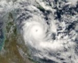
Cyclone Ingrid was a tropical cyclone
which struck northern Australia
during the 2004-05 Australian region cyclone season
. Its minimum pressure was 924 mbar
(hPa
).
on 3 March 2005. Although its sustained winds were high enough to be classified as a Category 4 storm, it diminished to Category 3 strength on 9 March as it moved west towards the Australian coast. The eye, with very destructive wind gusts up to 220 km/h within a 20 km radius, reached the far northern coast of the Australia
n state of Queensland
between 6 am and 9 am on 10 March 2005 AEST, and hit the Cape York Peninsula
as a Category 2 storm. However, it was downgraded to a Category 1 storm as it crossed the peninsula north of the towns of Coen
and Lockhart River
.
After passing the town of Weipa
, Ingrid gained strength once again as it moved out across the Gulf of Carpentaria
towards the Northern Territory
. It struck the town of Nhulunbuy as a Category 4 storm. It crossed the Cobourg Peninsula
in the early hours of 13 March, heading west. Ingrid crossed the Tiwi Islands
as a Category 3 storm, and moved west into the Timor Sea
. Winds were in excess of 200 km/h.
On 15 March Ingrid approached the north coast of the Kimberley region
of Western Australia
as a Category 4 storm, and made landfall near Kalumburu shortly afterwards. It quickly weakened as it moved inland, and soon completely dissipated.
(Note: The storm categories above are as defined by the Australian Bureau of Meteorology, and differ from those used in the United States.)
, several hundred residents, including some aborigines, evacuated from areas deemed vulnerable to shelters by 9 March. Tourists in resorts on Lizard Island
and Cape Tribulation
were evacuated the same day. Local communities throughout the coastline were supplied with sandbags and relief materials. To reduce damage from trees, workers cut numerous trees down ahead of the storm. Three aborigine communities, with a total population of 1,500, and nearby Cooktown
, home to 2,000 people, were placed on standby for evacuation. In Cairns
, emergency officials stockpiled sandbags and concerns were raised about 20% of the 130,000 people that live in the city never experiencing a cyclone within the past five years. In Lockhart River
, an estimated 700 people evacuated to shelters prior to the storm. On the western coast of Queensland, residents took precautions prior to a weakened Ingrid as a "code blue alert" was declared.
to evacuate to higher ground. On Melville Island, 1,500 aborigines evacuated to shelter throughout the island. One of the most important local events, the Australian rules football final, was canceled due to Ingrid. On Croker Island
, 300 residents evacuated to cyclone shelters prior to the storm.
, residents in the most vulnerable areas were evacuated to shelters.
suffered considerable damage, and there was localised flooding in the coastal areas due to high tides.
On Croker Island
, 30 homes sustained damage, some of which lost their roofs, numerous trees were downed, power was cut to most residences, cars were completely destroyed and numerous roads were damaged. Nearly all trees on the island were leveled by 290 km/h (180.2 mph) wind gusts. Schools were reportedly destroyed in addition to several homes. Much of the infrastructure of the Tiwi Islands
was affected, some suffering consequential damage due to trees falling on buildings and vehicles. Damages on the islands amounted to A$5 million ($3.9 million USD). Throughout the Northern Territory, an additional $A10 million ($6.4 million USD) in damages resulted from Ingrid.
Darwin
experienced high winds and heavy rain, but was only affected by the southern edge of the cyclone.
was closed between Kununurra
and Halls Creek
for a period of 36 hours due to flooding.
A resort area, known as "Faraway Bay", northeast of Kalumburu was completely destroyed by the storm. Numerous boats were found 100 m (328.1 ft) inland after being washed away by the storm surge. Numerous homes lost power and water supply, some sustained major roof damage and severe flooding isolated a few communities. Large areas of forested area were completely destroyed by Ingrid.
Tropical cyclone
A tropical cyclone is a storm system characterized by a large low-pressure center and numerous thunderstorms that produce strong winds and heavy rain. Tropical cyclones strengthen when water evaporated from the ocean is released as the saturated air rises, resulting in condensation of water vapor...
which struck northern Australia
Australia
Australia , officially the Commonwealth of Australia, is a country in the Southern Hemisphere comprising the mainland of the Australian continent, the island of Tasmania, and numerous smaller islands in the Indian and Pacific Oceans. It is the world's sixth-largest country by total area...
during the 2004-05 Australian region cyclone season
2004-05 Australian region cyclone season
The 2004–05 Australian region cyclone season was an event in the ongoing cycle of tropical cyclone formation. It began on 1 November 2004 and ended on 30 April 2005...
. Its minimum pressure was 924 mbar
Bar (unit)
The bar is a unit of pressure equal to 100 kilopascals, and roughly equal to the atmospheric pressure on Earth at sea level. Other units derived from the bar are the megabar , kilobar , decibar , centibar , and millibar...
(hPa
Pascal (unit)
The pascal is the SI derived unit of pressure, internal pressure, stress, Young's modulus and tensile strength, named after the French mathematician, physicist, inventor, writer, and philosopher Blaise Pascal. It is a measure of force per unit area, defined as one newton per square metre...
).
Meteorological history
Ingrid developed in the Coral SeaCoral Sea
The Coral Sea is a marginal sea off the northeast coast of Australia. It is bounded in the west by the east coast of Queensland, thereby including the Great Barrier Reef, in the east by Vanuatu and by New Caledonia, and in the north approximately by the southern extremity of the Solomon Islands...
on 3 March 2005. Although its sustained winds were high enough to be classified as a Category 4 storm, it diminished to Category 3 strength on 9 March as it moved west towards the Australian coast. The eye, with very destructive wind gusts up to 220 km/h within a 20 km radius, reached the far northern coast of the Australia
Australia
Australia , officially the Commonwealth of Australia, is a country in the Southern Hemisphere comprising the mainland of the Australian continent, the island of Tasmania, and numerous smaller islands in the Indian and Pacific Oceans. It is the world's sixth-largest country by total area...
n state of Queensland
Queensland
Queensland is a state of Australia, occupying the north-eastern section of the mainland continent. It is bordered by the Northern Territory, South Australia and New South Wales to the west, south-west and south respectively. To the east, Queensland is bordered by the Coral Sea and Pacific Ocean...
between 6 am and 9 am on 10 March 2005 AEST, and hit the Cape York Peninsula
Cape York Peninsula
Cape York Peninsula is a large remote peninsula located in Far North Queensland at the tip of the state of Queensland, Australia, the largest unspoilt wilderness in northern Australia and one of the last remaining wilderness areas on Earth...
as a Category 2 storm. However, it was downgraded to a Category 1 storm as it crossed the peninsula north of the towns of Coen
Coen, Queensland
Coen is a small inland town on the main road heading up the Cape York Peninsula in far northern Queensland, Australia. It is in the Cook Shire Local Government Area. At the 2006 census, Coen had a population of 253....
and Lockhart River
Lockhart River, Queensland
Lockhart River is a coastal Aboriginal community situated on the eastern coast of Cape York Peninsula in Queensland, Australia. The population consists mostly of Aboriginal and Torres Strait Islanders, whose ancestors were forcibly moved to the area beginning in 1924...
.
After passing the town of Weipa
Weipa, Queensland
Weipa is the largest town on the Gulf of Carpentaria coast of the Cape York Peninsula in Queensland, Australia. At the 2006 census, Weipa had a population of 2,830; the largest community on Cape York Peninsula. It exists because of the enormous bauxite deposits along the coast...
, Ingrid gained strength once again as it moved out across the Gulf of Carpentaria
Gulf of Carpentaria
The Gulf of Carpentaria is a large, shallow sea enclosed on three sides by northern Australia and bounded on the north by the Arafura Sea...
towards the Northern Territory
Northern Territory
The Northern Territory is a federal territory of Australia, occupying much of the centre of the mainland continent, as well as the central northern regions...
. It struck the town of Nhulunbuy as a Category 4 storm. It crossed the Cobourg Peninsula
Cobourg Peninsula
The Cobourg Peninsula is located 350 kilometres east of Darwin in the Northern Territory, Australia. It is deeply indented with coves and bays, covers a land area of about 2,100 km², and is virtually uninhabited with a population ranging from about 20 to 30 in five family outstations, but...
in the early hours of 13 March, heading west. Ingrid crossed the Tiwi Islands
Melville Island, Northern Territory
Melville Island or Yermalner Island lies in the eastern Timor Sea, off the coast of the Northern Territory of Australia. It is west of the Cobourg Peninsula in Arnhem Land and north of Darwin....
as a Category 3 storm, and moved west into the Timor Sea
Timor Sea
The Timor Sea is a relatively shallow sea bounded to the north by the island of Timor, to the east by the Arafura Sea, to the south by Australia and to the west by the Indian Ocean....
. Winds were in excess of 200 km/h.
On 15 March Ingrid approached the north coast of the Kimberley region
Kimberley region of Western Australia
The Kimberley is one of the nine regions of Western Australia. It is located in the northern part of Western Australia, bordered on the west by the Indian Ocean, on the north by the Timor Sea, on the south by the Great Sandy and Tanami Deserts, and on the east by the Northern Territory.The region...
of Western Australia
Western Australia
Western Australia is a state of Australia, occupying the entire western third of the Australian continent. It is bounded by the Indian Ocean to the north and west, the Great Australian Bight and Indian Ocean to the south, the Northern Territory to the north-east and South Australia to the south-east...
as a Category 4 storm, and made landfall near Kalumburu shortly afterwards. It quickly weakened as it moved inland, and soon completely dissipated.
(Note: The storm categories above are as defined by the Australian Bureau of Meteorology, and differ from those used in the United States.)
Queensland
In Far North QueenslandFar North Queensland
Far North Queensland, or FNQ, is the northernmost part of the Australian state of Queensland. The region, which contains a large section of the Tropical North Queensland area, stretches from the city of Cairns north to the Torres Strait...
, several hundred residents, including some aborigines, evacuated from areas deemed vulnerable to shelters by 9 March. Tourists in resorts on Lizard Island
Lizard Island National Park
Lizard Island is a national park on the Great Barrier Reef in Queensland , 1624 km northwest of Brisbane and part of the Lizard Island Group that also includes Palfrey Island.-Geology:...
and Cape Tribulation
Cape Tribulation
Cape Tribulation is a headland and locality in northern Queensland, Australia north of Cairns. It is located within the Daintree National Park and the Wet Tropics World Heritage area. At the 2006 census, Cape Tribulation had a population of 101....
were evacuated the same day. Local communities throughout the coastline were supplied with sandbags and relief materials. To reduce damage from trees, workers cut numerous trees down ahead of the storm. Three aborigine communities, with a total population of 1,500, and nearby Cooktown
Cooktown, Queensland
Cooktown is a small town located at the mouth of the Endeavour River, on Cape York Peninsula in Far North Queensland where James Cook beached his ship, the Endeavour, for repairs in 1770. At the 2006 census, Cooktown had a population of 1,336...
, home to 2,000 people, were placed on standby for evacuation. In Cairns
Cairns, Queensland
Cairns is a regional city in Far North Queensland, Australia, founded 1876. The city was named after William Wellington Cairns, then-current Governor of Queensland. It was formed to serve miners heading for the Hodgkinson River goldfield, but experienced a decline when an easier route was...
, emergency officials stockpiled sandbags and concerns were raised about 20% of the 130,000 people that live in the city never experiencing a cyclone within the past five years. In Lockhart River
Lockhart River, Queensland
Lockhart River is a coastal Aboriginal community situated on the eastern coast of Cape York Peninsula in Queensland, Australia. The population consists mostly of Aboriginal and Torres Strait Islanders, whose ancestors were forcibly moved to the area beginning in 1924...
, an estimated 700 people evacuated to shelters prior to the storm. On the western coast of Queensland, residents took precautions prior to a weakened Ingrid as a "code blue alert" was declared.
Northern Territory
On 11 March, officials in the Northern Territory advised the 4,000 residents of NhulunbuyNhulunbuy, Northern Territory
Nhulunbuy is the name of the township created on the Gove Peninsula in the Northern Territory of Australia when a bauxite mine and deep water port were established nearby in the late 1960s...
to evacuate to higher ground. On Melville Island, 1,500 aborigines evacuated to shelter throughout the island. One of the most important local events, the Australian rules football final, was canceled due to Ingrid. On Croker Island
Croker Island
Croker Island is an island in the Arafura Sea off the coast of the Northern Territory, Australia, 200 km northeast of Darwin. It is separated from Cobourg Peninsula in the west by Bowen Strait, which is 2.5 km wide in the south and up to 7 km in the north, and 8.5 km long. In...
, 300 residents evacuated to cyclone shelters prior to the storm.
Western Australia
In KalumburuKalumburu, Western Australia
Kalumburu and Kalumburu Community are both bounded localities within the Shire of Wyndham-East Kimberley Western Australia. Kalumburu Community is the northernmost settlement in Western Australia...
, residents in the most vulnerable areas were evacuated to shelters.
Papua New Guinea
Rough seas produced by Cyclone Ingrid capsized a boat off the coast of Papua New Guinea, killing five of the 13 occupants.Queensland
Damages from the storm in Queensland amounted to A$5.3 million ($4.1 million USD).Northern Territory
The isolated communities along the coast of Northern TerritoryNorthern Territory
The Northern Territory is a federal territory of Australia, occupying much of the centre of the mainland continent, as well as the central northern regions...
suffered considerable damage, and there was localised flooding in the coastal areas due to high tides.
On Croker Island
Croker Island
Croker Island is an island in the Arafura Sea off the coast of the Northern Territory, Australia, 200 km northeast of Darwin. It is separated from Cobourg Peninsula in the west by Bowen Strait, which is 2.5 km wide in the south and up to 7 km in the north, and 8.5 km long. In...
, 30 homes sustained damage, some of which lost their roofs, numerous trees were downed, power was cut to most residences, cars were completely destroyed and numerous roads were damaged. Nearly all trees on the island were leveled by 290 km/h (180.2 mph) wind gusts. Schools were reportedly destroyed in addition to several homes. Much of the infrastructure of the Tiwi Islands
Tiwi Islands
The Tiwi Islands are part of Australia's Northern Territory, north of Darwin where the Arafura Sea joins the Timor Sea. They comprise Melville Island and Bathurst Island, with a combined area of ....
was affected, some suffering consequential damage due to trees falling on buildings and vehicles. Damages on the islands amounted to A$5 million ($3.9 million USD). Throughout the Northern Territory, an additional $A10 million ($6.4 million USD) in damages resulted from Ingrid.
Darwin
Darwin, Northern Territory
Darwin is the capital city of the Northern Territory, Australia. Situated on the Timor Sea, Darwin has a population of 127,500, making it by far the largest and most populated city in the sparsely populated Northern Territory, but the least populous of all Australia's capital cities...
experienced high winds and heavy rain, but was only affected by the southern edge of the cyclone.
Western Australia
The Great Northern HighwayGreat Northern Highway
The Great Northern Highway is a generally north-south Western Australian highway which links the state's capital Perth with its most northern port, Wyndham. It is in length, with being National Highway...
was closed between Kununurra
Kununurra, Western Australia
Kununurra is a town in far northern Western Australia located at the eastern extremity of the Kimberley Region approximately from the border with the Northern Territory. Kununurra was initiated to service the Ord River Irrigation scheme....
and Halls Creek
Halls Creek, Western Australia
Halls Creek is a small town situated in the East Kimberley region of Western Australia. It is located between the towns of Fitzroy Crossing and Turkey Creek on the Great Northern Highway...
for a period of 36 hours due to flooding.
A resort area, known as "Faraway Bay", northeast of Kalumburu was completely destroyed by the storm. Numerous boats were found 100 m (328.1 ft) inland after being washed away by the storm surge. Numerous homes lost power and water supply, some sustained major roof damage and severe flooding isolated a few communities. Large areas of forested area were completely destroyed by Ingrid.
External links
- Australian Bureau of Meteorology: Tropical Cyclone Ingrid
- Darwin spared Ingrid's fury (Aust BC News, 14 March 2005. 10:58pm, AEDT)
- Ingrid batters top end (from ABC News Online - Saturday, 12 March 2005. 8:36pm AEDT)
- Cyclone Ingrid maintains intensity (from ABC News Online - Wednesday, 9 March 2005. 1:03am AEDT)
- Emergency services prepare for Cyclone Ingrid (from ABC News Online - Tuesday, 8 March 2005. 10:09pm AEDT)
- The wind velocities were subsequently reassessed based on meteorological and observed damage on the ground and findings delivered at a seminar in Darwin on 7 September 2005.