
Typhoon Tip
Encyclopedia
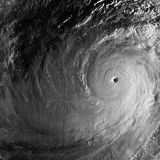
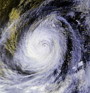
Typhoon Tip was the largest and most intense tropical cyclone
on record. The nineteenth tropical storm and twelfth typhoon of the 1979 Pacific typhoon season
, Tip developed out of a disturbance in the monsoon
trough
on October 4 near Pohnpei
. Initially, a tropical storm to its northwest hindered the development and motion of Tip, though after it tracked further north Tip was able to intensify. After passing Guam
, it rapidly intensified
and reached peak winds of 305 km/h (190 mph)All wind speeds in the article are maximum sustained wind
s sustained for one minute, unless otherwise noted. and a worldwide record low sea-level pressure of 870 mbar (hPa, 25.69 inHg) on October 12. At its peak strength, it was also the largest tropical cyclone on record with a diameter of 2,220 km (1,380 mi
). It slowly weakened as it continued west-northwestward, and later turned to the northeast under the influence of an approaching trough
. Tip made landfall
on southern Japan on October 19, and became an extratropical cyclone
shortly thereafter.
U.S. Air Force Reconnaissance
flew into the typhoon for 60 missions, making Tip one of the most closely observed tropical cyclones. Rainfall from the typhoon breached a flood-retaining wall at a United States Marine Corps
training camp in the Kanagawa Prefecture
of Japan, leading to a fire which killed 13 Marines and injured 68. Elsewhere in the country, the typhoon led to widespread flooding and 42 deaths, and offshore shipwrecks left 44 killed or missing.
that extended from the Philippines
to the Marshall Islands
. A disturbance to the southwest of Guam
developed into Tropical Storm Roger on October 3, and later on the same day the tropical disturbance which would later become Typhoon Tip developed to the south of Pohnpei
. Strong flow from across the equator was drawn into the circulation
of Roger, initially preventing significant development
of the disturbance that would become Tip. Despite the unfavorable air pattern, the tropical disturbance near Pohnpei gradually organized as it moved westward. Due to the large-scale circulation pattern into Tropical Storm Roger, the tropical disturbance moved erratically and slowly executed a cyclonic loop to the southeast of Chuuk
. A Reconnaissance Aircraft
flight into the system late on October 4 confirmed the existence of a closed low-level circulation, and early on October 5 the Joint Typhoon Warning Center
(JTWC) issued its first warning on Tropical Depression Twenty-Three.
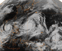
While executing a loop near Chuuk, the tropical depression intensified into Tropical Storm Tip, though the storm failed to organize significantly due to the influence of Tropical Storm Roger. Reconnaissance aircraft provided the track of the surface circulation, since satellite imagery estimated the center was located about 60 km (38 mi) from its true position. After drifting erratically for several days, Tip began a steady northwest motion on October 8. By that time, Tropical Storm Roger had become an extratropical cyclone
, resulting in the southerly flow to be entrained into Tip. Additionally, an area of the tropical upper tropospheric trough
moved to the north of Guam
, providing an excellent outflow channel
north of Tip. Initially, the storm was predicted to continue northwestward and make landfall on Guam, though early on October 9 it turned to the west, passing about 45 km (28 mi) south of the island. Later that day, Tip intensified to attain typhoon status.
 As a result of very favorable conditions for development, Typhoon Tip rapidly intensified
in the open waters of the western Pacific Ocean
. Late on October 10, the typhoon attained the equivalence of a Category 4 on the Saffir-Simpson Hurricane Scale
, and the next day it became a super typhoon
. The central pressure
dropped 92 mbar (hPa, 2.71 inHg) from October 9 to 11, during which the circulation pattern of Typhoon Tip increased to a record diameter of 2,220 km (1,380 mi). The typhoon continued to intensify further, and early on October 12 Reconnaissance Aircraft recorded a worldwide record-low pressure
of 870 mbar (hPa, 25.69 inHg) with winds of 305 km/h (190 mph), located about 840 km (520 mi) west-northwest of Guam
. In its best track, the Japan Meteorological Agency
listed Tip as peaking with 10-minute sustained winds of 160 mph (260 km/h). At the time of its peak strength, its eye
was 15 km (9.3 mi) wide. On the afternoon of October 13, Tip crossed 135°E
prompting the Philippine Weather Bureau
to issue warnings on Typhoon Tip assigning the local name Warling.
After peaking in intensity, Tip weakened to a 230 km/h (145 mph) typhoon and remained at that intensity for several days as it continued west-northwestward. For five days after reaching its peak strength, the average radius of winds stronger than 55 km/h (35 mph) extended over 1,100 km (685 mi). On October 17, Tip began to steadily weaken as its size reduced, and the next day it began recurving northeastward under the influence of a mid-level trough
. After passing about 65 km (45 mi) east of Okinawa, it accelerated its forward motion to 75 km/h (46 mph). On October 19 Tip made landfall
on the Japanese island of Honshū
with winds of about 130 km/h (80 mph). The typhoon continued rapidly northeastward through the country and became an extratropical cyclone
over northern Honshū a few hours after moving ashore. The extratropical remnant of Tip continued northeastward and gradually weakened, crossing the International Date Line
on October 22. It was last observed near the Aleutian Islands near Alaska
.
 The typhoon produced heavy rainfall early in its lifetime while passing near Guam
, including a total of 23.1 cm (9.09 in) at Andersen Air Force Base
. The outer rainband
s of the large circulation of Tip produced moderate rainfall in the mountainous regions of the Philippine
island of Luzon
.
Heavy rainfall from the typhoon breached a flood-retaining wall at Camp Fuji, a training facility for the United States Marine Corps
near Yokosuka
. Marines inside the camp weathered the storm inside huts situated at the base of a hill which housed a fuel farm. The breach led to hoses being dislodged from two rubber storage bladders, releasing large quantities of fuel. The fuel flowed down the hill and was ignited by a heater used to warm one of the huts. The resultant fire killed thirteen Marines, injuring 68, and causing moderate damage to the facility. The facility's barracks were destroyed, along with fifteen huts and several other structures. Fire departments from nearby locations arrived within two hours. The barracks were rebuilt, and a memorial was established for those who lost their lives in the fire.
During recurvature, Typhoon Tip passed about 65 km (40 mi) east of Okinawa. Sustained winds reached 72 km/h (44 mph), with gusts to 112 km/h (69 mph). Sustained wind velocities in Japan are not known, though they were estimated at minimal typhoon strength. The passage of the typhoon through the region resulted in millions of dollars in damage to the agricultural and fishing industries of the country. Eight ships were grounded or sunk by Tip, leaving 44 fishermen dead or unaccounted for. A Chinese freighter broke in half as a result of the typhoon, though its crew of 46 were rescued. The rainfall led to over 600 mudslides throughout the mountainous regions of Japan and flooded more than 22,000 homes; 42 people died throughout the country, with another 71 missing and 283 injured. River embankments broke in 70 places, destroying 27 bridges, while about 105 dikes were destroyed. Following the storm, at least 11,000 people were left homeless. Transportation in the country was disrupted; 200 trains and 160 domestic airline flights were canceled. Tip was described as the most severe storm to strike Japan in 13 years.
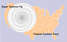
 Typhoon Tip was the largest tropical cyclone on record, with a diameter of 1,380 mi (2,220 km)—almost double the previous record of 700 miles (1,130 km) set by Typhoon Marge in August 1951. At its largest, Tip was nearly half as large as the continental United States
. At its peak intensity, the temperature inside the eye
of Typhoon Tip was 30 °C
(86 °F
) and described as exceptionally high. With 10-minute sustained winds of 160 mph (260 km/h), Typhoon Tip is the strongest cyclone in the complete tropical cyclone listing by the Japan Meteorological Agency
.
The typhoon was also the most intense tropical cyclone on record with a pressure of 870 mbar (hPa, 25.69 inHg), 6 mbar (hPa, 0.17 inHg) lower than previous record set by Super Typhoon June in 1975
. The records set by Tip still stand. However, due to the end of routine Reconnaissance Aircraft
in the western Pacific Ocean
in August 1987, modern researchers questioned if Tip is the strongest on record. After a detailed study, three researchers determined three typhoons, Angela
in 1995, Megi
in 2010 and Gay in 1992, maintained higher Dvorak numbers
than Tip, and believed that one or both of the two may have been more intense than Tip. Also, Cyclone Monica
of 2006
was rated at 869 mb by Dvorak classifications, although this was dismissed as the source was unofficial. So far, due to lack of direct observations
, it is unknown if Tip maintains the world record. Despite the intensity and damage, the name was not retired. As such, the name was reused in 1983, 1986, and 1989.
Tropical cyclone
A tropical cyclone is a storm system characterized by a large low-pressure center and numerous thunderstorms that produce strong winds and heavy rain. Tropical cyclones strengthen when water evaporated from the ocean is released as the saturated air rises, resulting in condensation of water vapor...
on record. The nineteenth tropical storm and twelfth typhoon of the 1979 Pacific typhoon season
1979 Pacific typhoon season
The 1979 Pacific typhoon season has no official bounds; it ran year-round in 1979, but most tropical cyclones tend to form in the northwestern Pacific Ocean between June and December...
, Tip developed out of a disturbance in the monsoon
Monsoon
Monsoon is traditionally defined as a seasonal reversing wind accompanied by corresponding changes in precipitation, but is now used to describe seasonal changes in atmospheric circulation and precipitation associated with the asymmetric heating of land and sea...
trough
Trough (meteorology)
A trough is an elongated region of relatively low atmospheric pressure, often associated with fronts.Unlike fronts, there is not a universal symbol for a trough on a weather chart. The weather charts in some countries or regions mark troughs by a line. In the United States, a trough may be marked...
on October 4 near Pohnpei
Pohnpei
Not to be confused with Pompeii, the ancient city destroyed by Vesuvius in AD 79.Pohnpei "upon a stone altar " is the name of one of the four states in the Federated States of Micronesia , situated among the Senyavin Islands which are part of the larger Caroline Islands group...
. Initially, a tropical storm to its northwest hindered the development and motion of Tip, though after it tracked further north Tip was able to intensify. After passing Guam
Guam
Guam is an organized, unincorporated territory of the United States located in the western Pacific Ocean. It is one of five U.S. territories with an established civilian government. Guam is listed as one of 16 Non-Self-Governing Territories by the Special Committee on Decolonization of the United...
, it rapidly intensified
Rapid deepening
Rapid deepening, also known as rapid intensification, is a meteorological condition that occurs when the minimum sea-level atmospheric pressure of a tropical cyclone decreases drastically in a short period of time. The National Weather Service describes rapid deepening as a decrease of...
and reached peak winds of 305 km/h (190 mph)All wind speeds in the article are maximum sustained wind
Maximum sustained wind
The maximum sustained winds associated with a tropical cyclone are a common indicator of the intensity of the storm. Within a mature tropical cyclone, they are found within the eyewall at a distance defined as the radius of maximum wind, or RMW. Unlike gusts, the value of these winds are...
s sustained for one minute, unless otherwise noted. and a worldwide record low sea-level pressure of 870 mbar (hPa, 25.69 inHg) on October 12. At its peak strength, it was also the largest tropical cyclone on record with a diameter of 2,220 km (1,380 mi
Mile
A mile is a unit of length, most commonly 5,280 feet . The mile of 5,280 feet is sometimes called the statute mile or land mile to distinguish it from the nautical mile...
). It slowly weakened as it continued west-northwestward, and later turned to the northeast under the influence of an approaching trough
Trough (meteorology)
A trough is an elongated region of relatively low atmospheric pressure, often associated with fronts.Unlike fronts, there is not a universal symbol for a trough on a weather chart. The weather charts in some countries or regions mark troughs by a line. In the United States, a trough may be marked...
. Tip made landfall
Landfall (meteorology)
Landfall is the event of a tropical cyclone or a waterspout coming onto land after being over water. When a waterspout makes landfall it is reclassified as a tornado, which can then cause damage inland...
on southern Japan on October 19, and became an extratropical cyclone
Extratropical cyclone
Extratropical cyclones, sometimes called mid-latitude cyclones or wave cyclones, are a group of cyclones defined as synoptic scale low pressure weather systems that occur in the middle latitudes of the Earth having neither tropical nor polar characteristics, and are connected with fronts and...
shortly thereafter.
U.S. Air Force Reconnaissance
Hurricane Hunters
The Hurricane Hunters are aircraft that fly into tropical cyclones in the North Atlantic Ocean and Northeastern Pacific Ocean for the specific purpose of directly measuring weather data in and around those storms. In the United States, the Air Force, Navy, and NOAA units have all participated in...
flew into the typhoon for 60 missions, making Tip one of the most closely observed tropical cyclones. Rainfall from the typhoon breached a flood-retaining wall at a United States Marine Corps
United States Marine Corps
The United States Marine Corps is a branch of the United States Armed Forces responsible for providing power projection from the sea, using the mobility of the United States Navy to deliver combined-arms task forces rapidly. It is one of seven uniformed services of the United States...
training camp in the Kanagawa Prefecture
Kanagawa Prefecture
is a prefecture located in the southern Kantō region of Japan. The capital is Yokohama. Kanagawa is part of the Greater Tokyo Area.-History:The prefecture has some archaeological sites going back to the Jōmon period...
of Japan, leading to a fire which killed 13 Marines and injured 68. Elsewhere in the country, the typhoon led to widespread flooding and 42 deaths, and offshore shipwrecks left 44 killed or missing.
Meteorological history
Three circulations developed within the monsoon troughMonsoon trough
The monsoon trough is that portion of the Intertropical Convergence Zone which extends into or through a monsoon circulation, as depicted by a line on a weather map showing the locations of minimum sea level pressure, and as such, is a convergence zone between the wind patterns of the southern and...
that extended from the Philippines
Philippines
The Philippines , officially known as the Republic of the Philippines , is a country in Southeast Asia in the western Pacific Ocean. To its north across the Luzon Strait lies Taiwan. West across the South China Sea sits Vietnam...
to the Marshall Islands
Marshall Islands
The Republic of the Marshall Islands , , is a Micronesian nation of atolls and islands in the middle of the Pacific Ocean, just west of the International Date Line and just north of the Equator. As of July 2011 the population was 67,182...
. A disturbance to the southwest of Guam
Guam
Guam is an organized, unincorporated territory of the United States located in the western Pacific Ocean. It is one of five U.S. territories with an established civilian government. Guam is listed as one of 16 Non-Self-Governing Territories by the Special Committee on Decolonization of the United...
developed into Tropical Storm Roger on October 3, and later on the same day the tropical disturbance which would later become Typhoon Tip developed to the south of Pohnpei
Pohnpei
Not to be confused with Pompeii, the ancient city destroyed by Vesuvius in AD 79.Pohnpei "upon a stone altar " is the name of one of the four states in the Federated States of Micronesia , situated among the Senyavin Islands which are part of the larger Caroline Islands group...
. Strong flow from across the equator was drawn into the circulation
Atmospheric circulation
Atmospheric circulation is the large-scale movement of air, and the means by which thermal energy is distributed on the surface of the Earth....
of Roger, initially preventing significant development
Tropical cyclogenesis
Tropical cyclogenesis is the term that describes the development and strengthening of a tropical cyclone in the atmosphere. The mechanisms through which tropical cyclogenesis occurs are distinctly different from those through which mid-latitude cyclogenesis occurs...
of the disturbance that would become Tip. Despite the unfavorable air pattern, the tropical disturbance near Pohnpei gradually organized as it moved westward. Due to the large-scale circulation pattern into Tropical Storm Roger, the tropical disturbance moved erratically and slowly executed a cyclonic loop to the southeast of Chuuk
Chuuk
Chuuk — formerly Truk, Ruk, Hogoleu, Torres, Ugulat, and Lugulus — is an island group in the south western part of the Pacific Ocean. It comprises one of the four states of the Federated States of Micronesia , along with Kosrae, Pohnpei, and Yap. Chuuk is the most populous of the FSM's...
. A Reconnaissance Aircraft
Hurricane Hunters
The Hurricane Hunters are aircraft that fly into tropical cyclones in the North Atlantic Ocean and Northeastern Pacific Ocean for the specific purpose of directly measuring weather data in and around those storms. In the United States, the Air Force, Navy, and NOAA units have all participated in...
flight into the system late on October 4 confirmed the existence of a closed low-level circulation, and early on October 5 the Joint Typhoon Warning Center
Joint Typhoon Warning Center
The Joint Typhoon Warning Center is a joint United States Navy – United States Air Force task force located at the Naval Maritime Forecast Center in Pearl Harbor, Hawaii...
(JTWC) issued its first warning on Tropical Depression Twenty-Three.
While executing a loop near Chuuk, the tropical depression intensified into Tropical Storm Tip, though the storm failed to organize significantly due to the influence of Tropical Storm Roger. Reconnaissance aircraft provided the track of the surface circulation, since satellite imagery estimated the center was located about 60 km (38 mi) from its true position. After drifting erratically for several days, Tip began a steady northwest motion on October 8. By that time, Tropical Storm Roger had become an extratropical cyclone
Extratropical cyclone
Extratropical cyclones, sometimes called mid-latitude cyclones or wave cyclones, are a group of cyclones defined as synoptic scale low pressure weather systems that occur in the middle latitudes of the Earth having neither tropical nor polar characteristics, and are connected with fronts and...
, resulting in the southerly flow to be entrained into Tip. Additionally, an area of the tropical upper tropospheric trough
Tropical Upper Tropospheric Trough
A tropical upper tropospheric trough , also known as the mid-oceanic trough, is a trough situated in upper-level tropics. Its formation is usually caused by the intrusion of energy and wind from the mid-latitudes into the tropics. It can also develop from the inverted trough adjacent to an upper...
moved to the north of Guam
Guam
Guam is an organized, unincorporated territory of the United States located in the western Pacific Ocean. It is one of five U.S. territories with an established civilian government. Guam is listed as one of 16 Non-Self-Governing Territories by the Special Committee on Decolonization of the United...
, providing an excellent outflow channel
Outflow (meteorology)
Outflow, in meteorology, is air that flows outwards from a storm system. It is associated with ridging, or anticyclonic flow. In the low levels of the troposphere, outflow radiates from thunderstorms in the form of a wedge of rain-cooled air, which is visible as a thin rope-like cloud on weather...
north of Tip. Initially, the storm was predicted to continue northwestward and make landfall on Guam, though early on October 9 it turned to the west, passing about 45 km (28 mi) south of the island. Later that day, Tip intensified to attain typhoon status.
Rapid deepening
Rapid deepening, also known as rapid intensification, is a meteorological condition that occurs when the minimum sea-level atmospheric pressure of a tropical cyclone decreases drastically in a short period of time. The National Weather Service describes rapid deepening as a decrease of...
in the open waters of the western Pacific Ocean
Pacific Ocean
The Pacific Ocean is the largest of the Earth's oceanic divisions. It extends from the Arctic in the north to the Southern Ocean in the south, bounded by Asia and Australia in the west, and the Americas in the east.At 165.2 million square kilometres in area, this largest division of the World...
. Late on October 10, the typhoon attained the equivalence of a Category 4 on the Saffir-Simpson Hurricane Scale
Saffir-Simpson Hurricane Scale
The Saffir–Simpson Hurricane Scale , or the Saffir–Simpson Hurricane Wind Scale , classifies hurricanes — Western Hemisphere tropical cyclones that exceed the intensities of tropical depressions and tropical storms — into five categories distinguished by the intensities of their sustained winds...
, and the next day it became a super typhoon
Tropical cyclone scales
Tropical systems are officially ranked on one of several tropical cyclone scales according to their maximum sustained winds and in what oceanic basin they are located...
. The central pressure
Pressure
Pressure is the force per unit area applied in a direction perpendicular to the surface of an object. Gauge pressure is the pressure relative to the local atmospheric or ambient pressure.- Definition :...
dropped 92 mbar (hPa, 2.71 inHg) from October 9 to 11, during which the circulation pattern of Typhoon Tip increased to a record diameter of 2,220 km (1,380 mi). The typhoon continued to intensify further, and early on October 12 Reconnaissance Aircraft recorded a worldwide record-low pressure
Atmospheric pressure
Atmospheric pressure is the force per unit area exerted into a surface by the weight of air above that surface in the atmosphere of Earth . In most circumstances atmospheric pressure is closely approximated by the hydrostatic pressure caused by the weight of air above the measurement point...
of 870 mbar (hPa, 25.69 inHg) with winds of 305 km/h (190 mph), located about 840 km (520 mi) west-northwest of Guam
Guam
Guam is an organized, unincorporated territory of the United States located in the western Pacific Ocean. It is one of five U.S. territories with an established civilian government. Guam is listed as one of 16 Non-Self-Governing Territories by the Special Committee on Decolonization of the United...
. In its best track, the Japan Meteorological Agency
Japan Meteorological Agency
The or JMA, is the Japanese government's weather service. Charged with gathering and reporting weather data and forecasts in Japan, it is a semi-autonomous part of the Ministry of Land, Infrastructure and Transport...
listed Tip as peaking with 10-minute sustained winds of 160 mph (260 km/h). At the time of its peak strength, its eye
Eye (cyclone)
The eye is a region of mostly calm weather found at the center of strong tropical cyclones. The eye of a storm is a roughly circular area and typically 30–65 km in diameter. It is surrounded by the eyewall, a ring of towering thunderstorms where the second most severe weather of a cyclone...
was 15 km (9.3 mi) wide. On the afternoon of October 13, Tip crossed 135°E
135th meridian east
The meridian 135° east of Greenwich is a line of longitude that extends from the North Pole across the Arctic Ocean, Asia, the Pacific Ocean, Australasia, the Indian Ocean, the Southern Ocean, and Antarctica to the South Pole....
prompting the Philippine Weather Bureau
Philippine Atmospheric, Geophysical and Astronomical Services Administration
The Philippine Atmospheric, Geophysical and Astronomical Services Administration is a Philippine national institution dedicated to provide flood and typhoon warnings, public weather forecasts and advisories, meteorological, astronomical, climatological, and other specialized information and...
to issue warnings on Typhoon Tip assigning the local name Warling.
After peaking in intensity, Tip weakened to a 230 km/h (145 mph) typhoon and remained at that intensity for several days as it continued west-northwestward. For five days after reaching its peak strength, the average radius of winds stronger than 55 km/h (35 mph) extended over 1,100 km (685 mi). On October 17, Tip began to steadily weaken as its size reduced, and the next day it began recurving northeastward under the influence of a mid-level trough
Trough (meteorology)
A trough is an elongated region of relatively low atmospheric pressure, often associated with fronts.Unlike fronts, there is not a universal symbol for a trough on a weather chart. The weather charts in some countries or regions mark troughs by a line. In the United States, a trough may be marked...
. After passing about 65 km (45 mi) east of Okinawa, it accelerated its forward motion to 75 km/h (46 mph). On October 19 Tip made landfall
Landfall (meteorology)
Landfall is the event of a tropical cyclone or a waterspout coming onto land after being over water. When a waterspout makes landfall it is reclassified as a tornado, which can then cause damage inland...
on the Japanese island of Honshū
Honshu
is the largest island of Japan. The nation's main island, it is south of Hokkaido across the Tsugaru Strait, north of Shikoku across the Inland Sea, and northeast of Kyushu across the Kanmon Strait...
with winds of about 130 km/h (80 mph). The typhoon continued rapidly northeastward through the country and became an extratropical cyclone
Extratropical cyclone
Extratropical cyclones, sometimes called mid-latitude cyclones or wave cyclones, are a group of cyclones defined as synoptic scale low pressure weather systems that occur in the middle latitudes of the Earth having neither tropical nor polar characteristics, and are connected with fronts and...
over northern Honshū a few hours after moving ashore. The extratropical remnant of Tip continued northeastward and gradually weakened, crossing the International Date Line
International Date Line
The International Date Line is a generally north-south imaginary line on the surface of the Earth, passing through the middle of the Pacific Ocean, that designates the place where each calendar day begins...
on October 22. It was last observed near the Aleutian Islands near Alaska
Alaska
Alaska is the largest state in the United States by area. It is situated in the northwest extremity of the North American continent, with Canada to the east, the Arctic Ocean to the north, and the Pacific Ocean to the west and south, with Russia further west across the Bering Strait...
.
Impact
Guam
Guam is an organized, unincorporated territory of the United States located in the western Pacific Ocean. It is one of five U.S. territories with an established civilian government. Guam is listed as one of 16 Non-Self-Governing Territories by the Special Committee on Decolonization of the United...
, including a total of 23.1 cm (9.09 in) at Andersen Air Force Base
Andersen Air Force Base
Andersen Air Force Base is a United States Air Force base located approximately northeast of Yigo in the United States territory of Guam....
. The outer rainband
Rainband
A rainband is a cloud and precipitation structure associated with an area of rainfall which is significantly elongated. Rainbands can be stratiform or convective, and are generated by differences in temperature. When noted on weather radar imagery, this precipitation elongation is referred to as...
s of the large circulation of Tip produced moderate rainfall in the mountainous regions of the Philippine
Philippines
The Philippines , officially known as the Republic of the Philippines , is a country in Southeast Asia in the western Pacific Ocean. To its north across the Luzon Strait lies Taiwan. West across the South China Sea sits Vietnam...
island of Luzon
Luzon
Luzon is the largest island in the Philippines. It is located in the northernmost region of the archipelago, and is also the name for one of the three primary island groups in the country centered on the Island of Luzon...
.
Heavy rainfall from the typhoon breached a flood-retaining wall at Camp Fuji, a training facility for the United States Marine Corps
United States Marine Corps
The United States Marine Corps is a branch of the United States Armed Forces responsible for providing power projection from the sea, using the mobility of the United States Navy to deliver combined-arms task forces rapidly. It is one of seven uniformed services of the United States...
near Yokosuka
Yokosuka, Kanagawa
is a city located in Kanagawa, Japan. As of 2010, the city had an estimated population of 419,067 and a population density of 4,160 people per km². It covered an area of 100.62 km²...
. Marines inside the camp weathered the storm inside huts situated at the base of a hill which housed a fuel farm. The breach led to hoses being dislodged from two rubber storage bladders, releasing large quantities of fuel. The fuel flowed down the hill and was ignited by a heater used to warm one of the huts. The resultant fire killed thirteen Marines, injuring 68, and causing moderate damage to the facility. The facility's barracks were destroyed, along with fifteen huts and several other structures. Fire departments from nearby locations arrived within two hours. The barracks were rebuilt, and a memorial was established for those who lost their lives in the fire.
During recurvature, Typhoon Tip passed about 65 km (40 mi) east of Okinawa. Sustained winds reached 72 km/h (44 mph), with gusts to 112 km/h (69 mph). Sustained wind velocities in Japan are not known, though they were estimated at minimal typhoon strength. The passage of the typhoon through the region resulted in millions of dollars in damage to the agricultural and fishing industries of the country. Eight ships were grounded or sunk by Tip, leaving 44 fishermen dead or unaccounted for. A Chinese freighter broke in half as a result of the typhoon, though its crew of 46 were rescued. The rainfall led to over 600 mudslides throughout the mountainous regions of Japan and flooded more than 22,000 homes; 42 people died throughout the country, with another 71 missing and 283 injured. River embankments broke in 70 places, destroying 27 bridges, while about 105 dikes were destroyed. Following the storm, at least 11,000 people were left homeless. Transportation in the country was disrupted; 200 trains and 160 domestic airline flights were canceled. Tip was described as the most severe storm to strike Japan in 13 years.
Records and meteorological statistics
United States
The United States of America is a federal constitutional republic comprising fifty states and a federal district...
. At its peak intensity, the temperature inside the eye
Eye (cyclone)
The eye is a region of mostly calm weather found at the center of strong tropical cyclones. The eye of a storm is a roughly circular area and typically 30–65 km in diameter. It is surrounded by the eyewall, a ring of towering thunderstorms where the second most severe weather of a cyclone...
of Typhoon Tip was 30 °C
Celsius
Celsius is a scale and unit of measurement for temperature. It is named after the Swedish astronomer Anders Celsius , who developed a similar temperature scale two years before his death...
(86 °F
Fahrenheit
Fahrenheit is the temperature scale proposed in 1724 by, and named after, the German physicist Daniel Gabriel Fahrenheit . Within this scale, the freezing of water into ice is defined at 32 degrees, while the boiling point of water is defined to be 212 degrees...
) and described as exceptionally high. With 10-minute sustained winds of 160 mph (260 km/h), Typhoon Tip is the strongest cyclone in the complete tropical cyclone listing by the Japan Meteorological Agency
Japan Meteorological Agency
The or JMA, is the Japanese government's weather service. Charged with gathering and reporting weather data and forecasts in Japan, it is a semi-autonomous part of the Ministry of Land, Infrastructure and Transport...
.
The typhoon was also the most intense tropical cyclone on record with a pressure of 870 mbar (hPa, 25.69 inHg), 6 mbar (hPa, 0.17 inHg) lower than previous record set by Super Typhoon June in 1975
1975 Pacific typhoon season
The 1975 Pacific typhoon season has no official bounds; it ran year-round in 1975, but most tropical cyclones tend to form in the northwestern Pacific Ocean between June and December...
. The records set by Tip still stand. However, due to the end of routine Reconnaissance Aircraft
Reconnaissance aircraft
A reconnaissance aircraft is a manned military aircraft designed, or adapted, to carry out aerial reconnaissance.-History:The majority of World War I aircraft were reconnaissance designs...
in the western Pacific Ocean
Pacific Ocean
The Pacific Ocean is the largest of the Earth's oceanic divisions. It extends from the Arctic in the north to the Southern Ocean in the south, bounded by Asia and Australia in the west, and the Americas in the east.At 165.2 million square kilometres in area, this largest division of the World...
in August 1987, modern researchers questioned if Tip is the strongest on record. After a detailed study, three researchers determined three typhoons, Angela
Typhoon Angela (1995)
Super Typhoon Angela was a very powerful Category 5 typhoon with sustained winds.Angela caused 9.33 billion Philippine pesos in damage across the Philippines, resulting in 882 fatalities...
in 1995, Megi
Typhoon Megi (2010)
Typhoon Megi was one of the most intense tropical cyclones on record, attaining the lowest atmospheric pressure since Vanessa in 1984 and the highest 10-minute sustained winds since Bess in 1982 in the northwestern Pacific Ocean...
in 2010 and Gay in 1992, maintained higher Dvorak numbers
Dvorak technique
The Dvorak technique is a widely used system to subjectively estimate tropical cyclone intensity based solely on visible and infrared satellite images. Several agencies issue Dvorak intensity numbers for cyclones of sufficient intensity...
than Tip, and believed that one or both of the two may have been more intense than Tip. Also, Cyclone Monica
Cyclone Monica
Severe Tropical Cyclone Monica was the most intense tropical cyclone, in terms of maximum sustained winds, on record to impact Australia. The 17th storm of the 2005–06 Australian region cyclone season, Monica originated from an area of low pressure off the coast of Papua New Guinea on 16 April...
of 2006
2005-06 Australian region cyclone season
The 2005–06 Australian region cyclone season was an event in the ongoing cycle of tropical cyclone formation. It began on 1 November 2005 and ended on 30 April 2006...
was rated at 869 mb by Dvorak classifications, although this was dismissed as the source was unofficial. So far, due to lack of direct observations
Tropical cyclone observation
Tropical cyclone observation has been carried out over the past couple of centuries in various ways. The passage of typhoons, hurricanes, as well as other tropical cyclones have been detected by word of mouth from sailors recently coming to port or by radio transmissions from ships at sea, from...
, it is unknown if Tip maintains the world record. Despite the intensity and damage, the name was not retired. As such, the name was reused in 1983, 1986, and 1989.
See also
- List of tropical cyclone records
- Other tropical cyclones named TipTyphoon Tip (disambiguation)The name Tip has been used for four tropical cyclones in the northwest Pacific Ocean.*1979's Super Typhoon Tip - The largest and most intense tropical cyclone ever recorded in the world. Peaked as a Category 5 with winds of 190 mph and a pressure of 870 mb...
- Pacific typhoonPacific typhoonA typhoon is a mature tropical cyclone that develops in the northwestern part of the Pacific Ocean between 180° and 100°E. This region is referred to as the northwest Pacific basin. For organizational purposes, the northern Pacific Ocean is divided into three regions: the eastern , central , and...
- Great Hurricane of 1780Great Hurricane of 1780The Great Hurricane of 1780, also known as Hurricane San Calixto, the Great Hurricane of the Antilles, and the 1780 Disaster, is the deadliest Atlantic hurricane on record. Over 20,000 people died when the storm passed through the Lesser Antilles in the Caribbean between October 10 and October...
- Typhoon Nancy