
Teesta River
Encyclopedia
Sikkim
Sikkim is a landlocked Indian state nestled in the Himalayan mountains...
, flowing for almost the entire length of the state and carving out verdant Himalayan temperate and tropical river valleys. The emerald-coloured river then forms the border between Sikkim and West Bengal
West Bengal
West Bengal is a state in the eastern region of India and is the nation's fourth-most populous. It is also the seventh-most populous sub-national entity in the world, with over 91 million inhabitants. A major agricultural producer, West Bengal is the sixth-largest contributor to India's GDP...
before joining the Brahmaputra as a tributary in Bangladesh
Bangladesh
Bangladesh , officially the People's Republic of Bangladesh is a sovereign state located in South Asia. It is bordered by India on all sides except for a small border with Burma to the far southeast and by the Bay of Bengal to the south...
. The total length of the river is 315 kilometres (195.7 mi).
Course
The river originates from Khangchung Tso Lake in North Sikkim at an elevation of 5330 m (17,487 ft) above sea level in the Himalaya. This lake lies to the east of the Donkia pass next to the Western base of PauhunriPauhunri
Pauhunri is a mountain in the Eastern Himalayas. It is located on the border of Sikkim, India and Tibet, China, and is situated about 75 km northeast of Kangchenjunga....
and is formed by the melting of the Tista Khantse glacier.
The Teesta river is then fed by rivulets which arise in the Thangu, Yumthang and Donkia-La ranges. The river then flows past the town of Rangpo
Rangpo
Rangpo is a town in East Sikkim in the Indian state of Sikkim. The town borders West Bengal and is situated along the river Teesta. It is the first Sikkimese town on NH-31A which links Siliguri to Gangtok. It is about 200 m above sea level giving it a sub-tropical climate...
where it forms the border between Sikkim and West Bengal up to Teesta Bazaar
Teesta Bazaar
Teesta Bazaar is a junction on National Highway 31A on the Siliguri-Gangtok highway in Darjeeling district of the state of West Bengal, India. Teesta Bazaar is on the right bank of Teesta River. Continuing upriver on the right bank from Siliguri, the road leads to Darjeeling. The river is crossed...
. Just before the Teesta Bridge, which joins Kalimpong with Darjeeling, the river is met by its main tributary
Tributary
A tributary or affluent is a stream or river that flows into a main stem river or a lake. A tributary does not flow directly into a sea or ocean...
, the Rangeet River
Rangeet River
Rangeet or Rangit is a tributary of the Teesta river, the largest river in the Indian state of Sikkim. The Rangeet river originates in the Himalayan mountains in West Sikkim district. A perennial river, it is fed by the melting snow of the Himalayas in early summer and the monsoon rains in...
. At this point, it changes course southwards flowing into West Bengal. The river hits the plains at Sevoke
Sevoke
Sevoke is a town near Siliguri in the Darjeeling District of West Bengal, India. It is a part of Dooars. Many army and BSF camps are located in the area. The Mahananda Wildlife Sanctuary is situated in this area. National Highway 31 passes through the town...
, at a distance of 22 Km from Siliguri
Siliguri
Siliguri is a city in the Indian state of West Bengal. It is located in the Siliguri Corridor or Chicken's Neck - a very narrow strip of land linking mainland India to its north-eastern states. It is also the transit point for air, road and rail traffic to the neighbouring countries of Nepal,...
, where it is spanned by the Coronation Bridge
Coronation Bridge
The Coronation Bridge, also known as the Sevoke Bridge, in Darjeeling district of West Bengal, India, spans across the Teesta River, connecting the districts of Darjeeling and Jalpaiguri. National Highway 31 runs across it....
which links the north-east states to the rest of India
India
India , officially the Republic of India , is a country in South Asia. It is the seventh-largest country by geographical area, the second-most populous country with over 1.2 billion people, and the most populous democracy in the world...
. The river then courses its way to Jalpaiguri
Jalpaiguri
Jalpaiguri is a city in the state of West Bengal, India. It is the headquarters of Jalpaiguri district, and the divisional headquarters of the North Bengal region.-History:...
and then to Rangpur District
Rangpur District
The district of Rangpur have 4924 mosques, 480 temples, 43 churches and six tombs.In an anthropologic view most people of Rangpur are having Rajbagshi blood in their veins...
of Bangladesh, before finally merging with the mighty Brahmaputra at Fulchori.
Geography
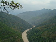
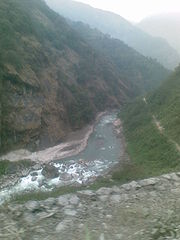
Ravine
A ravine is a landform narrower than a canyon and is often the product of streamcutting erosion. Ravines are typically classified as larger in scale than gullies, although smaller than valleys. A ravine is generally a fluvial slope landform of relatively steep sides, on the order of twenty to...
s and gorges
Gorges
Gorges, the plural of the French word for "throat", usually refers to a canyon.Gorges is the name or part of the name of several communes in France:* Gorges, in the Loire-Atlantique département* Gorges, in the Manche département...
in Sikkim meandering through the hills with the hill station
Hill station
A hill station is a town located at a higher elevation than the nearby plain or valley. The term was used mostly in colonial Asia , but also in Africa , for towns founded by European colonial rulers as refuges from the summer heat, up where temperatures are cooler...
of Kalimpong lying just off the river. Variegated vegetation can be seen along this route. At lower elevations, tropical deciduous
Deciduous
Deciduous means "falling off at maturity" or "tending to fall off", and is typically used in reference to trees or shrubs that lose their leaves seasonally, and to the shedding of other plant structures such as petals after flowering or fruit when ripe...
trees and shrubs cover the surrounding hills; alpine vegetation
Alpine climate
Alpine climate is the average weather for a region above the tree line. This climate is also referred to as mountain climate or highland climate....
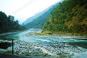
is seen at the upper altitudes. The river is flanked by white sand which is used by the construction industry in the region. Large boulders in and around the waters make it ideal for rafting
Rafting
Rafting or white water rafting is a challenging recreational outdoor activity using an inflatable raft to navigate a river or other bodies of water. This is usually done on white water or different degrees of rough water, in order to thrill and excite the raft passengers. The development of this...
enthusiasts.
Between the towns of Rangpo and Lohapul, the Teesta flows with a very strong current, ideal for white river rafting. Towns like Teesta Bazaar and Melli
Melli
Melli is a town on the West Bengal-Sikkim border near the River Teesta.The appellation Melli in Nepali means "the place where the dead are cremated". Melli is one of the few towns in India that lie in two different states. A bridge named Jawaharlal Nehru Bridge connects the two parts of the town....
have facilities for group rafting. Though an innocuous-looking river, the underlying current is very strong. In 1915, G.P. Robertson, the then Municipal Engineer of Darjeeling, drowned after losing control of the boat in the turbulence while surveying the river. The boat struck a partially hidden boulder and was sucked in by a whirlpool, leaving no trace of the occupants.
During the monsoon
Monsoon
Monsoon is traditionally defined as a seasonal reversing wind accompanied by corresponding changes in precipitation, but is now used to describe seasonal changes in atmospheric circulation and precipitation associated with the asymmetric heating of land and sea...
s, this humble river distends its banks; both in size and turbulence. Landslide
Landslide
A landslide or landslip is a geological phenomenon which includes a wide range of ground movement, such as rockfalls, deep failure of slopes and shallow debris flows, which can occur in offshore, coastal and onshore environments...
s in this region often dam up parts of the river in this season.
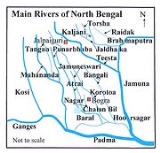
Changes in course of rivers
Great changes have taken place in the course of some of the rivers in BengalBengal
Bengal is a historical and geographical region in the northeast region of the Indian Subcontinent at the apex of the Bay of Bengal. Today, it is mainly divided between the sovereign land of People's Republic of Bangladesh and the Indian state of West Bengal, although some regions of the previous...
and the adjoining areas, during the period since 1500 AD. Although positive evidence is lacking, similar changes can be assumed in the remoter past. The Teesta river is one of the rivers that has changed over the years.
The Teesta earlier ran due south from Jalpaiguri
Jalpaiguri
Jalpaiguri is a city in the state of West Bengal, India. It is the headquarters of Jalpaiguri district, and the divisional headquarters of the North Bengal region.-History:...
in three channels, namely, the Karatoya
Karatoya River
Karatoya River , a small stream in Rajshahi Division of Bangladesh, was once a large and sacred river. A channel of it presently flows by the ancient ruins of Mahasthangarh in Bogra District. The Karatoya mahatmya bears testimony to its past greatness...
to the east, the Punarbhaba
Punarbhaba River
The Punarbhaba is a river of Bangladesh and West Bengal in India, of total length about 160 km and a width of 3–8 km and it's mean depth is It originates from the lowlands of Thakurgaon District of Bangladesh. The river's upper part is a few kilometres west of Atrai. Dinajpur district...
in the west and the Atrai
Atrai River
Atrai River flows in West Bengal and northern parts of Bangladesh.In ancient times the river was called Atrei and finds a mention in the Mahabharata. It is linked with Karatoya River. It originates in West Bengal and then after flowing through Dinajpur District of Bangladesh, it enters India again...
in the centre. The three channels possibly gave the name to the river as Trisrota (possessed of three streams) which has been shortened and corrupted to Teesta. Of these three, the Punarbhaba joined the Mahananda
Mahananda River
The Mahananda River is a trans-boundary river that flows through the Indian states of West Bengal and Bihar, and Bangladesh. Right bank tributary Mechi forms part of Nepal's eastern boundary with West Bengal and the Kankai crosses out of Nepal.-Course:...
. The Atrai passing through a vast marshy area known as Chalan Beel
Chalan Beel
Chalan Beel is a wetland in Bangladesh. It is a large inland depression, marshy in character, with rich flora and fauna. Forty-seven rivers and other waterways flow into the Chalan Beel...
joined the Karatoya and the united stream joined the Padma
Padma River
The Padma is a major trans-boundary river in Bangladesh. It is the main distributary of the Ganges , which originates in the Himalayas. The Padma enters Bangladesh from India near Chapai Nababganj...
near Jafarganj. In the destructive floods of 1787, the Teesta river forsook its old channel and rushing south-east it joined the Brahmaputra
Brahmaputra River
The Brahmaputra , also called Tsangpo-Brahmaputra, is a trans-boundary river and one of the major rivers of Asia. It is the only Indian river that is attributed the masculine gender and thus referred to as a in Indo-Aryan languages and languages with Indo-Aryan influence...
.
Rennel made a survey between 1764 and 1777 and his maps are one of the earliest authentic maps of Bengal in existence. In these maps Teesta is shown as flowing through North Bengal in several branches — Punarbhaba, Atrai, Karatoya, etc. All these streams combined lower down with the Mahananda, now the westernmost river in North Bengal, and taking the name of Hoorsagar finally discharged into the Ganges at Jafarganj, near modern Goalundo. The Hoorsagar river is still in existence, being the combined outfall of the Baral
Baral River
Baral river is one of the offshoots of the Ganges, starts its journey at Charghat Upazila of Rajshahi District of Bangladesh. The Baral flows through Natore and Pabna meets with the Gumani at the east of Bhangura and finally meets with the Hurasagar river after joining with the Karatoya south of...
, a spill channel of the Ganges, the Atrai, the Jamuna or Jamuneswari (not the main Jamuna through which the Brahmaputra now flows), and the Karatoya, but instead of falling into the Ganges, it falls into the main Jamuna, a few miles above its confluence with the Padma at Goalundo.
Proposed dams
India has proposed a series of dams within the Teesta river that should produce some 50,000 MW of electricity within the next 10 years. With some of the largest sediment loads, the creation of a reservoir will lead to an increased pressure on an active fault area. There are concerns that the building of these dams may lead to river-induced seismicityInduced seismicity
Induced seismicity refers to typically minor earthquakes and tremors that are caused by human activity that alters the stresses and strains on the Earth's crust. Most induced seismicity is of an extremely low magnitude...
. Despite such worries the construction of the dams had started.
Climate and tectonics of Teesta River
The Teesta river has preserved good imprints of climatic and tectonics along its valleys and catchments. The significant fluvial landscape of the Teesta river has been described by few workers, e.g. Archarya, Mukhopadhyay, Malay Mukul, Ingocha Meetei Lukram, etc. International papers published about the Teesta river can be counted on the fingers. The recent paper of Ingocha Meetei Lukram suggested that climate change, particularly on a millennial to multi-millennial scale, during late QuaternaryQuaternary
The Quaternary Period is the most recent of the three periods of the Cenozoic Era in the geologic time scale of the ICS. It follows the Neogene Period, spanning 2.588 ± 0.005 million years ago to the present...
had a strong system-wide influence on sediment production, transport and deposition in the Teesta river system (Meetei et al., 2007)
The interrelationship between climate, erosion, deposition and tectonic activities is not properly understood to date. However, it appears that major alluviation and incision events could be ascribed to the factors associated with climatic processes such as strengthening or weakening of monsoonal precipitation and related fluvial discharge. Tectonic activity affects sediment fluxes and is responsible for the insetting of younger terraces/fanlobes into the older terraces/fanlobes. During seismic events, landslide activity along the slopes of river valleys influences sediment delivery into the valleys, causing the effects of tectonics to be intricately coupled with that of climate (Meetei et al. 2007).
The terraces and floodplains, valley-side slopes and landslide slopes, alluvial cones of different generations, kettle-shaped depressions, sickle-shaped ranges, leveled plains, undulating plains and deeply dissected valleys, and glacial and periglacial deposits are some of the geomorphological features observed in the Teesta river basin in Sikkim (Mukhopadhayay, 1982). Three prominent knick points have been observed along the Teesta river profiles which correspond to the zones of tectonic discontinuities, the important ones being the MCT and MBT (e.g. Seeber and Gornitz, 1983). From the recent studies of Mukul (2000) and Mukul et al. (2007), it is proved that the southern part of the frontal wedge near the foothill zone is tectonically active along with the formation of NKT, SKT and MFT structures within the sub-Himalaya in the Teesta basin.