

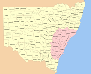
Cadastral divisions of New South Wales
Encyclopedia
Australia
Australia , officially the Commonwealth of Australia, is a country in the Southern Hemisphere comprising the mainland of the Australian continent, the island of Tasmania, and numerous smaller islands in the Indian and Pacific Oceans. It is the world's sixth-largest country by total area...
n state of New South Wales
New South Wales
New South Wales is a state of :Australia, located in the east of the country. It is bordered by Queensland, Victoria and South Australia to the north, south and west respectively. To the east, the state is bordered by the Tasman Sea, which forms part of the Pacific Ocean. New South Wales...
, which are further subdivided into 7,459 parish
Parish
A parish is a territorial unit historically under the pastoral care and clerical jurisdiction of one parish priest, who might be assisted in his pastoral duties by a curate or curates - also priests but not the parish priest - from a more or less central parish church with its associated organization...
es. There are also three Land Divisions, around 100 Land Districts, and several other types of districts as well as land boards used at various periods. There were also thirteen hundreds proclaimed in Cumberland County, which were later abolished. These divisions are part of the Lands administrative divisions of Australia. Unlike the Local Government Areas of New South Wales
Local Government Areas of New South Wales
The local government areas of New South Wales, Australia have been subject to periodic bouts of restructuring and rationalisation by the State Government, involving voluntary and involuntary amalgamation of areas...
, which have gone through restructuring periods by the government, the counties have been the same since the nineteenth century.
Creation of county areas
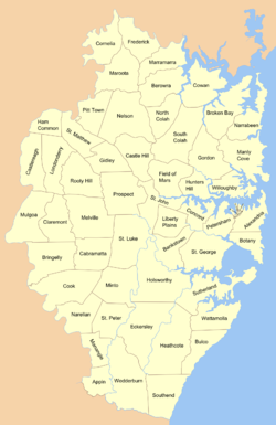
Cumberland County, New South Wales
Cumberland County is a county in the State of New South Wales, Australia. Most of the Sydney metropolitan area is located within the County of Cumberland....
on 6 June 1788. Northumberland
Northumberland County, New South Wales
Northumberland County was one of the original Nineteen Counties in New South Wales and is now one of the 141 Cadastral divisions of New South Wales. It included the area to the north of Broken Bay, including Lake Macquarie and Newcastle...
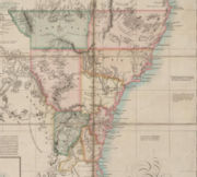
was named in 1804. Several other counties were established around Sydney; by the 1820s there were nine counties (see 1828 and 1832 maps). They were: Roxburgh, Northumberland, Durham, Westmoreland, Cumberland, Argyle, Camden, Ayr and Cambridge. They were in the approximate area of the present day cadastral units except that some of them were larger and took up land which was in 1834 assigned to other counties. Ayr and Cambridge were not used in the 1834 counties, taking up area which is approximately in what became Macquarie County and Brisbane County.
Instructions were given to Governor Brisbane
Thomas Brisbane
Major-General Sir Thomas Makdougall Brisbane, 1st Baronet GCH, GCB, FRS, FRSE was a British soldier, colonial Governor and astronomer.-Early life:...
in 1825 to survey New South Wales and divide it into counties of various sizes, hundreds, and parishes between 15 and 25 square miles (40 and 65 km²). The Nineteen Counties
Nineteen Counties
The Nineteen Counties were the limits of location in the colony of New South Wales defined by the Governor of New South Wales Sir Ralph Darling in 1826 in accordance with a government order from Lord Bathurst, the secretary of State. Counties had been used since the first year of settlement, with...
were surveyed by Thomas Mitchell in 1834. Thirteen hundreds were proclaimed in Cumberland county, but not in anywhere else in New South Wales, and these were repealed in 1888.
As the counties are based on area, rather than population, there are huge differences in the populations of the coastal counties with those for the remote west. The whole of Sydney with several million people is located within Cumberland County, while there are many counties for areas in the Far West
Far West (New South Wales)
The Far West region of New South Wales, Australia refers generally to a fairly flat and low lying area in the western part of the state, which is too dry to support wheat or other crops or intensive pastoral. It is west of the North West Slopes, Central West and the Riverina...
which have a very low population.
Use
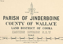
The counties have little official function and are only now used for land titles and geographic surveying, and as an area of coverage within some industrial awards. Yancowinna CountyYancowinna County, New South Wales
Yancowinna County is one of the 141 Cadastral divisions of New South Wales. It contains the city of Broken Hill and village of Silverton.Some New South Wales industrial relations laws have excluded the county of Yancowinna...
is also legally the only part of the state in the South Australian timezone.
Genealogy records from the nineteenth and early twentieth centuries for New South Wales commonly use the town name followed by the county. The 1911 Britannica
Encyclopædia Britannica Eleventh Edition
The Encyclopædia Britannica Eleventh Edition is a 29-volume reference work, an edition of the Encyclopædia Britannica. It was developed during the encyclopaedia's transition from a British to an American publication. Some of its articles were written by the best-known scholars of the time...
lists all towns in New South Wales the same way, such as Albury, Goulburn county, Broken Hill, Yancowinna county and Wagga Wagga, Wynyard county.
Early land districts
Parts of the land in which were outside the Nineteen Counties were divided into squatting districts in the early nineteenth century http://www.nla.gov.au/apps/cdview?pi=nla.map-nk5928-sd. In 1846 New South Wales was divided into settled districts, intermediate districts and unsettled districts. . In 1861 the system of settled and unsettled districts were abolished with the Crown Lands ActsRobertson Land Acts
The Crown Lands Acts 1861 were introduced by the New South Wales Premier, John Robertson, in 1861 to reform land holdings and in particular to break the squatters' domination of land tenure...
, while new types of districts called first and second class settled districts, as well as town land and suburban land came into being. The various districts used:
- Albert District (west of the Darling RiverDarling RiverThe Darling River is the third longest river in Australia, measuring from its source in northern New South Wales to its confluence with the Murray River at Wentworth, New South Wales. Including its longest contiguous tributaries it is long, making it the longest river system in Australia.The...
) - Bligh District, east of the Macquarie RiverMacquarie RiverThe Macquarie River is one of the main inland rivers in New South Wales. Its headwaters rise in the central highlands of New South Wales near the town of Oberon. The river travels generally northwest past the towns of Bathurst, Wellington, Dubbo, Narromine, and Warren to the Macquarie Marshes...
. (1841 population of 402, with 118,341 sheep and 24,064 cattle) In 1852, it was described as being 5 million acres (20,000 km²), with 140,000 sheep, 40,000 cattle and 2,000 horses. - Clarence River District. In 1852, it was described as being 5 million acres (20,000 km²), with 200,000 sheep, 40,000 cattle and 2,000 horses.
- Gwydir District (MoreeMoree, New South WalesMoree is a large town in Moree Plains Shire in northern New South Wales, Australia. It is located on the banks of the Mehi River in the centre of the rich black-soil plains....
area) - Lachlan District - between the Lachlan RiverLachlan River- Course :The river rises in the central highland of New South Wales, part of the Great Dividing Range, 13 km east of Gunning. Its major headwaters, the Carcoar River, the Belubula River and the Abercrombie River converge near the town of Cowra. Minor tributaries include the Morongla Creek...
and Murrumbidgee RiverMurrumbidgee RiverThe Murrumbidgee River is a major river in the state of New South Wales, Australia, and the Australian Capital Territory . A major tributary of the Murray River, the Murrumbidgee flows in a west-northwesterly direction from the foot of Peppercorn Hill in the Fiery Range of the Snowy Mountains,...
. (1841 population of 792, with 111,154 sheep and 57,920 cattle) - Liverpool Plains District (1841 population of 1012, with 230,102 sheep, 102,738 cattle and 1045 horses) In 1852, it was described as being larger than 10 million acres (40,000 km²), with 400,000 sheep, 220,000 cattle and 4,000 horses. There was an Electoral district of Liverpool PlainsElectoral district of Liverpool PlainsLiverpool Plains was an electoral district of the Legislative Assembly in the Australian state of New South Wales, created in 1859 and including the Liverpool Plains and the extensive pastoral district around the Gwydir River in the northwest of the state. It was created when the seat of...
in the same area in the nineteenth century, and the Liverpool Plains Shire is the modern shire. - Lower Darling District (east of the Darling River)
- Maneroo District (south coast, now called MonaroMonaro, New South WalesMonaro is the name of a region in the south of New South Wales, Australia. A small area of Victoria near Snowy River National Park is geographically part of the Monaro, whilst the Australian Capital Territory is frequently considered part of the region: most towns have very close links with...
) - south of the Moruya RiverMoruya RiverThe Moruya River is in southern New South Wales, Australia. Its freshwater reaches are known as the Deua River.The headwaters of the Moruya River rise as the Deua River south of Braidwood...
and Queanbeyan RiverQueanbeyan RiverThe Queanbeyan River is a tributary of the Molonglo River and part of Murray-Darling Basin. The river is 70 kilometres in length and the river catchment is 96,000 hectares in size...
, and east of the Murrumbidgee River (1841 population of 1554, with 230,130 sheep, 78,473 cattle and 2133 horses) In 1852, it was described as having 400,000 sheep, 115,000 cattle and 5,000 horses. - McLeay River District
- Murrumbidgee DistrictMurrumbidgee DistrictThe Murrumbidgee District was a district used in New South Wales in the nineteenth century to refer to the land between the Murrumbidgee River and Murray River, that is now mostly known as the Riverina region...
(between the Murrumbidgee and Murray rivers) (1841 population of 1139, with 180,654 sheep and 62,848 cattle) In 1852, it was described as being 12 million acres (49,000 km²), with 400,000 sheep, 100,000 cattle and 3,000 horses. - New England District (New EnglandNew England (Australia)New England or New England North West is the name given to a generally undefined region about 60 kilometres inland, that includes the Northern Tablelands and the North West Slopes regions in the north of the state of New South Wales, Australia.-History:The region has been occupied by Indigenous...
region (1841 population of 702 with 201,926 sheep and 13,830 cattle) - Port Macquarie District. (1841 population of 287, with 11,642 sheep and 5,885 cattle)
- Warrego District (between Darling River and Queensland border in the north)
- Wellington District, between the Lachlan River and Macquarie River. (1841 population of 656, with 119,441 sheep and 26,370 cattle)
Land divisions, boards and districts
Central Division (New South Wales)
The Central Division of New South Wales is one of the three divisions of New South Wales along with the Eastern and Western divisions, established under the Crown Lands Act of 1884 for the purposes of land management. In 1907, it included the Hay, Forbes, Dubbo and Moree land boards, as well as the...
and Eastern
Eastern Division (New South Wales)
The Eastern Division of New South Wales is one of the three divisions of New South Wales along with the Central and Western divisions, established under the Crown Lands Act of 1884 for the purposes of land management. It is the most populated of the divisions, including Sydney and large coastal...
; as well as Land Boards and Land Districts. This 1890 map shows 14 land boards and 95 land districts; while a 1907 map shows 13 land boards and 103 land districts. The new land districts were different to the previous land districts which had mostly been used in the western areas of the state before counties were proclaimed there. The land boards were named after the location of the head office. The table below shows the land districts used in 1890 and 1907 (some of the locations of the land boards changed and there were new land districts), with the land boards and land divisions:
| Land District | Land Board (1890) | Land Board (1907) | Land Division |
|---|---|---|---|
| Albury | Wagga Wagga | Wagga Wagga | Eastern Eastern Division (New South Wales) The Eastern Division of New South Wales is one of the three divisions of New South Wales along with the Central and Western divisions, established under the Crown Lands Act of 1884 for the purposes of land management. It is the most populated of the divisions, including Sydney and large coastal... |
| Armidale | Armidale | Armidale | Eastern Eastern Division (New South Wales) The Eastern Division of New South Wales is one of the three divisions of New South Wales along with the Central and Western divisions, established under the Crown Lands Act of 1884 for the purposes of land management. It is the most populated of the divisions, including Sydney and large coastal... |
| Balranald South | Hay | Hay | Central Central Division (New South Wales) The Central Division of New South Wales is one of the three divisions of New South Wales along with the Eastern and Western divisions, established under the Crown Lands Act of 1884 for the purposes of land management. In 1907, it included the Hay, Forbes, Dubbo and Moree land boards, as well as the... |
| Balranald | Hay | Western | Western |
| Barmedman East | Forbes | Central Central Division (New South Wales) The Central Division of New South Wales is one of the three divisions of New South Wales along with the Eastern and Western divisions, established under the Crown Lands Act of 1884 for the purposes of land management. In 1907, it included the Hay, Forbes, Dubbo and Moree land boards, as well as the... |
|
| Barmedman | Forbes | Central Central Division (New South Wales) The Central Division of New South Wales is one of the three divisions of New South Wales along with the Eastern and Western divisions, established under the Crown Lands Act of 1884 for the purposes of land management. In 1907, it included the Hay, Forbes, Dubbo and Moree land boards, as well as the... |
|
| Bathurst | Orange | Orange | Eastern Eastern Division (New South Wales) The Eastern Division of New South Wales is one of the three divisions of New South Wales along with the Central and Western divisions, established under the Crown Lands Act of 1884 for the purposes of land management. It is the most populated of the divisions, including Sydney and large coastal... |
| Bega | Cooma | Goulburn | Eastern Eastern Division (New South Wales) The Eastern Division of New South Wales is one of the three divisions of New South Wales along with the Central and Western divisions, established under the Crown Lands Act of 1884 for the purposes of land management. It is the most populated of the divisions, including Sydney and large coastal... |
| Bellingen | Grafton | Eastern Eastern Division (New South Wales) The Eastern Division of New South Wales is one of the three divisions of New South Wales along with the Central and Western divisions, established under the Crown Lands Act of 1884 for the purposes of land management. It is the most populated of the divisions, including Sydney and large coastal... |
|
| Berrima | Sydney | Eastern | Eastern Eastern Division (New South Wales) The Eastern Division of New South Wales is one of the three divisions of New South Wales along with the Central and Western divisions, established under the Crown Lands Act of 1884 for the purposes of land management. It is the most populated of the divisions, including Sydney and large coastal... |
| Bingara | Moree | Moree | Central Central Division (New South Wales) The Central Division of New South Wales is one of the three divisions of New South Wales along with the Eastern and Western divisions, established under the Crown Lands Act of 1884 for the purposes of land management. In 1907, it included the Hay, Forbes, Dubbo and Moree land boards, as well as the... |
| Bombala | Cooma | Goulburn | Eastern Eastern Division (New South Wales) The Eastern Division of New South Wales is one of the three divisions of New South Wales along with the Central and Western divisions, established under the Crown Lands Act of 1884 for the purposes of land management. It is the most populated of the divisions, including Sydney and large coastal... |
| Boorowa | Goulburn | Goulburn | Eastern Eastern Division (New South Wales) The Eastern Division of New South Wales is one of the three divisions of New South Wales along with the Central and Western divisions, established under the Crown Lands Act of 1884 for the purposes of land management. It is the most populated of the divisions, including Sydney and large coastal... |
| Bourke | Bourke | Western | Western |
| Braidwood | Goulburn | Goulburn | Eastern Eastern Division (New South Wales) The Eastern Division of New South Wales is one of the three divisions of New South Wales along with the Central and Western divisions, established under the Crown Lands Act of 1884 for the purposes of land management. It is the most populated of the divisions, including Sydney and large coastal... |
| Breewarrina | Bourke | Western | Western |
| Breewarrina East | Bourke | Central Central Division (New South Wales) The Central Division of New South Wales is one of the three divisions of New South Wales along with the Eastern and Western divisions, established under the Crown Lands Act of 1884 for the purposes of land management. In 1907, it included the Hay, Forbes, Dubbo and Moree land boards, as well as the... |
|
| Campbelltown | Sydney | Eastern Eastern Division (New South Wales) The Eastern Division of New South Wales is one of the three divisions of New South Wales along with the Central and Western divisions, established under the Crown Lands Act of 1884 for the purposes of land management. It is the most populated of the divisions, including Sydney and large coastal... |
|
| Carcoar | Orange | Orange | Eastern Eastern Division (New South Wales) The Eastern Division of New South Wales is one of the three divisions of New South Wales along with the Central and Western divisions, established under the Crown Lands Act of 1884 for the purposes of land management. It is the most populated of the divisions, including Sydney and large coastal... |
| Casino | Grafton | Grafton | Eastern Eastern Division (New South Wales) The Eastern Division of New South Wales is one of the three divisions of New South Wales along with the Central and Western divisions, established under the Crown Lands Act of 1884 for the purposes of land management. It is the most populated of the divisions, including Sydney and large coastal... |
| Cassillis | Maitland | Eastern Eastern Division (New South Wales) The Eastern Division of New South Wales is one of the three divisions of New South Wales along with the Central and Western divisions, established under the Crown Lands Act of 1884 for the purposes of land management. It is the most populated of the divisions, including Sydney and large coastal... |
|
| Cobar | Bourke | Western | Western |
| Cobar East | Bourke | Central Central Division (New South Wales) The Central Division of New South Wales is one of the three divisions of New South Wales along with the Eastern and Western divisions, established under the Crown Lands Act of 1884 for the purposes of land management. In 1907, it included the Hay, Forbes, Dubbo and Moree land boards, as well as the... |
|
| Condobolin | Forbes | Forbes | Central Central Division (New South Wales) The Central Division of New South Wales is one of the three divisions of New South Wales along with the Eastern and Western divisions, established under the Crown Lands Act of 1884 for the purposes of land management. In 1907, it included the Hay, Forbes, Dubbo and Moree land boards, as well as the... |
| Cooma | Cooma | Goulburn | Eastern Eastern Division (New South Wales) The Eastern Division of New South Wales is one of the three divisions of New South Wales along with the Central and Western divisions, established under the Crown Lands Act of 1884 for the purposes of land management. It is the most populated of the divisions, including Sydney and large coastal... |
| Coonabarrabran | Tamworth | Tamworth | Central Central Division (New South Wales) The Central Division of New South Wales is one of the three divisions of New South Wales along with the Eastern and Western divisions, established under the Crown Lands Act of 1884 for the purposes of land management. In 1907, it included the Hay, Forbes, Dubbo and Moree land boards, as well as the... |
| Coonamble | Dubbo | Dubbo | Eastern Eastern Division (New South Wales) The Eastern Division of New South Wales is one of the three divisions of New South Wales along with the Central and Western divisions, established under the Crown Lands Act of 1884 for the purposes of land management. It is the most populated of the divisions, including Sydney and large coastal... |
| Cootamundry | Wagga Wagga | Wagga Wagga | Eastern Eastern Division (New South Wales) The Eastern Division of New South Wales is one of the three divisions of New South Wales along with the Central and Western divisions, established under the Crown Lands Act of 1884 for the purposes of land management. It is the most populated of the divisions, including Sydney and large coastal... |
| Cootamundry Central | Wagga Wagga | Eastern Eastern Division (New South Wales) The Eastern Division of New South Wales is one of the three divisions of New South Wales along with the Central and Western divisions, established under the Crown Lands Act of 1884 for the purposes of land management. It is the most populated of the divisions, including Sydney and large coastal... |
|
| Corowa | Wagga Wagga | Wagga Wagga | Central Central Division (New South Wales) The Central Division of New South Wales is one of the three divisions of New South Wales along with the Eastern and Western divisions, established under the Crown Lands Act of 1884 for the purposes of land management. In 1907, it included the Hay, Forbes, Dubbo and Moree land boards, as well as the... |
| Cowra | Orange | Orange | Eastern Eastern Division (New South Wales) The Eastern Division of New South Wales is one of the three divisions of New South Wales along with the Central and Western divisions, established under the Crown Lands Act of 1884 for the purposes of land management. It is the most populated of the divisions, including Sydney and large coastal... |
| Deniliquin | Hay | Hay | Central Central Division (New South Wales) The Central Division of New South Wales is one of the three divisions of New South Wales along with the Eastern and Western divisions, established under the Crown Lands Act of 1884 for the purposes of land management. In 1907, it included the Hay, Forbes, Dubbo and Moree land boards, as well as the... |
| Dubbo | Dubbo | Dubbo | Eastern Eastern Division (New South Wales) The Eastern Division of New South Wales is one of the three divisions of New South Wales along with the Central and Western divisions, established under the Crown Lands Act of 1884 for the purposes of land management. It is the most populated of the divisions, including Sydney and large coastal... |
| Dungog | Maitland | Maitland | Eastern Eastern Division (New South Wales) The Eastern Division of New South Wales is one of the three divisions of New South Wales along with the Central and Western divisions, established under the Crown Lands Act of 1884 for the purposes of land management. It is the most populated of the divisions, including Sydney and large coastal... |
| Eden | Cooma | Goulburn | Eastern Eastern Division (New South Wales) The Eastern Division of New South Wales is one of the three divisions of New South Wales along with the Central and Western divisions, established under the Crown Lands Act of 1884 for the purposes of land management. It is the most populated of the divisions, including Sydney and large coastal... |
| Forbes | Forbes | Forbes | Central Central Division (New South Wales) The Central Division of New South Wales is one of the three divisions of New South Wales along with the Eastern and Western divisions, established under the Crown Lands Act of 1884 for the purposes of land management. In 1907, it included the Hay, Forbes, Dubbo and Moree land boards, as well as the... |
| Glen Innes | Armidale | Armidale | Eastern Eastern Division (New South Wales) The Eastern Division of New South Wales is one of the three divisions of New South Wales along with the Central and Western divisions, established under the Crown Lands Act of 1884 for the purposes of land management. It is the most populated of the divisions, including Sydney and large coastal... |
| Gosford | Sydney | Maitland | Eastern Eastern Division (New South Wales) The Eastern Division of New South Wales is one of the three divisions of New South Wales along with the Central and Western divisions, established under the Crown Lands Act of 1884 for the purposes of land management. It is the most populated of the divisions, including Sydney and large coastal... |
| Goulburn | Goulburn | Goulburn | Eastern Eastern Division (New South Wales) The Eastern Division of New South Wales is one of the three divisions of New South Wales along with the Central and Western divisions, established under the Crown Lands Act of 1884 for the purposes of land management. It is the most populated of the divisions, including Sydney and large coastal... |
| Grafton | Grafton | Grafton | Eastern Eastern Division (New South Wales) The Eastern Division of New South Wales is one of the three divisions of New South Wales along with the Central and Western divisions, established under the Crown Lands Act of 1884 for the purposes of land management. It is the most populated of the divisions, including Sydney and large coastal... |
| Grenfell | Forbes | Forbes | Central Central Division (New South Wales) The Central Division of New South Wales is one of the three divisions of New South Wales along with the Eastern and Western divisions, established under the Crown Lands Act of 1884 for the purposes of land management. In 1907, it included the Hay, Forbes, Dubbo and Moree land boards, as well as the... |
| Gundagai | Wagga Wagga | Wagga Wagga | Eastern Eastern Division (New South Wales) The Eastern Division of New South Wales is one of the three divisions of New South Wales along with the Central and Western divisions, established under the Crown Lands Act of 1884 for the purposes of land management. It is the most populated of the divisions, including Sydney and large coastal... |
| Gunnedah | Tamworth | Tamworth | Central Central Division (New South Wales) The Central Division of New South Wales is one of the three divisions of New South Wales along with the Eastern and Western divisions, established under the Crown Lands Act of 1884 for the purposes of land management. In 1907, it included the Hay, Forbes, Dubbo and Moree land boards, as well as the... |
| Gunning | Goulburn | Goulburn | Eastern Eastern Division (New South Wales) The Eastern Division of New South Wales is one of the three divisions of New South Wales along with the Central and Western divisions, established under the Crown Lands Act of 1884 for the purposes of land management. It is the most populated of the divisions, including Sydney and large coastal... |
| Hay North | Hay | Western | Western |
| Hay | Hay | Hay | Central Central Division (New South Wales) The Central Division of New South Wales is one of the three divisions of New South Wales along with the Eastern and Western divisions, established under the Crown Lands Act of 1884 for the purposes of land management. In 1907, it included the Hay, Forbes, Dubbo and Moree land boards, as well as the... |
| Hillston North | Hay | Western | Western |
| Hillston | Hay | Hay | Central Central Division (New South Wales) The Central Division of New South Wales is one of the three divisions of New South Wales along with the Eastern and Western divisions, established under the Crown Lands Act of 1884 for the purposes of land management. In 1907, it included the Hay, Forbes, Dubbo and Moree land boards, as well as the... |
| Inverell | Armidale | Armidale | Eastern Eastern Division (New South Wales) The Eastern Division of New South Wales is one of the three divisions of New South Wales along with the Central and Western divisions, established under the Crown Lands Act of 1884 for the purposes of land management. It is the most populated of the divisions, including Sydney and large coastal... |
| Kempsey | Grafton | Grafton | Eastern Eastern Division (New South Wales) The Eastern Division of New South Wales is one of the three divisions of New South Wales along with the Central and Western divisions, established under the Crown Lands Act of 1884 for the purposes of land management. It is the most populated of the divisions, including Sydney and large coastal... |
| Kiama | Sydney | Sydney | Eastern Eastern Division (New South Wales) The Eastern Division of New South Wales is one of the three divisions of New South Wales along with the Central and Western divisions, established under the Crown Lands Act of 1884 for the purposes of land management. It is the most populated of the divisions, including Sydney and large coastal... |
| Lismore | Grafton | Grafton | Eastern Eastern Division (New South Wales) The Eastern Division of New South Wales is one of the three divisions of New South Wales along with the Central and Western divisions, established under the Crown Lands Act of 1884 for the purposes of land management. It is the most populated of the divisions, including Sydney and large coastal... |
| Lithgow | Sydney | Orange | Eastern Eastern Division (New South Wales) The Eastern Division of New South Wales is one of the three divisions of New South Wales along with the Central and Western divisions, established under the Crown Lands Act of 1884 for the purposes of land management. It is the most populated of the divisions, including Sydney and large coastal... |
| Liverpool | Sydney | Eastern Eastern Division (New South Wales) The Eastern Division of New South Wales is one of the three divisions of New South Wales along with the Central and Western divisions, established under the Crown Lands Act of 1884 for the purposes of land management. It is the most populated of the divisions, including Sydney and large coastal... |
|
| Maitland | Maitland | Maitland | Eastern Eastern Division (New South Wales) The Eastern Division of New South Wales is one of the three divisions of New South Wales along with the Central and Western divisions, established under the Crown Lands Act of 1884 for the purposes of land management. It is the most populated of the divisions, including Sydney and large coastal... |
| Metropolitan | Sydney | Sydney | Eastern Eastern Division (New South Wales) The Eastern Division of New South Wales is one of the three divisions of New South Wales along with the Central and Western divisions, established under the Crown Lands Act of 1884 for the purposes of land management. It is the most populated of the divisions, including Sydney and large coastal... |
| Milton | Sydney | Sydney | Eastern Eastern Division (New South Wales) The Eastern Division of New South Wales is one of the three divisions of New South Wales along with the Central and Western divisions, established under the Crown Lands Act of 1884 for the purposes of land management. It is the most populated of the divisions, including Sydney and large coastal... |
| Molong | Orange | Orange | Eastern Eastern Division (New South Wales) The Eastern Division of New South Wales is one of the three divisions of New South Wales along with the Central and Western divisions, established under the Crown Lands Act of 1884 for the purposes of land management. It is the most populated of the divisions, including Sydney and large coastal... |
| Moree | Moree | Moree | Central Central Division (New South Wales) The Central Division of New South Wales is one of the three divisions of New South Wales along with the Eastern and Western divisions, established under the Crown Lands Act of 1884 for the purposes of land management. In 1907, it included the Hay, Forbes, Dubbo and Moree land boards, as well as the... |
| Moruya | Sydney | Eastern Eastern Division (New South Wales) The Eastern Division of New South Wales is one of the three divisions of New South Wales along with the Central and Western divisions, established under the Crown Lands Act of 1884 for the purposes of land management. It is the most populated of the divisions, including Sydney and large coastal... |
|
| Mudgee | Orange | Orange | Eastern Eastern Division (New South Wales) The Eastern Division of New South Wales is one of the three divisions of New South Wales along with the Central and Western divisions, established under the Crown Lands Act of 1884 for the purposes of land management. It is the most populated of the divisions, including Sydney and large coastal... |
| Murrurundi | Tamworth | Tamworth | Eastern Eastern Division (New South Wales) The Eastern Division of New South Wales is one of the three divisions of New South Wales along with the Central and Western divisions, established under the Crown Lands Act of 1884 for the purposes of land management. It is the most populated of the divisions, including Sydney and large coastal... |
| Murwillumbah | Grafton | Grafton | Eastern Eastern Division (New South Wales) The Eastern Division of New South Wales is one of the three divisions of New South Wales along with the Central and Western divisions, established under the Crown Lands Act of 1884 for the purposes of land management. It is the most populated of the divisions, including Sydney and large coastal... |
| Muswellbrook | Maitland | Maitland | Eastern Eastern Division (New South Wales) The Eastern Division of New South Wales is one of the three divisions of New South Wales along with the Central and Western divisions, established under the Crown Lands Act of 1884 for the purposes of land management. It is the most populated of the divisions, including Sydney and large coastal... |
| Narrabri | Tamworth | Moree | Central Central Division (New South Wales) The Central Division of New South Wales is one of the three divisions of New South Wales along with the Eastern and Western divisions, established under the Crown Lands Act of 1884 for the purposes of land management. In 1907, it included the Hay, Forbes, Dubbo and Moree land boards, as well as the... |
| Narrandera | Wagga Wagga | Hay | Central Central Division (New South Wales) The Central Division of New South Wales is one of the three divisions of New South Wales along with the Eastern and Western divisions, established under the Crown Lands Act of 1884 for the purposes of land management. In 1907, it included the Hay, Forbes, Dubbo and Moree land boards, as well as the... |
| Newcastle | Maitland | Maitland | Eastern Eastern Division (New South Wales) The Eastern Division of New South Wales is one of the three divisions of New South Wales along with the Central and Western divisions, established under the Crown Lands Act of 1884 for the purposes of land management. It is the most populated of the divisions, including Sydney and large coastal... |
| Nowra | Sydney | Sydney | Eastern Eastern Division (New South Wales) The Eastern Division of New South Wales is one of the three divisions of New South Wales along with the Central and Western divisions, established under the Crown Lands Act of 1884 for the purposes of land management. It is the most populated of the divisions, including Sydney and large coastal... |
| Nyngan | Dubbo | Eastern Eastern Division (New South Wales) The Eastern Division of New South Wales is one of the three divisions of New South Wales along with the Central and Western divisions, established under the Crown Lands Act of 1884 for the purposes of land management. It is the most populated of the divisions, including Sydney and large coastal... |
|
| Orange | Orange | Orange | Eastern Eastern Division (New South Wales) The Eastern Division of New South Wales is one of the three divisions of New South Wales along with the Central and Western divisions, established under the Crown Lands Act of 1884 for the purposes of land management. It is the most populated of the divisions, including Sydney and large coastal... |
| Parkes | Forbes | Forbes | Central Central Division (New South Wales) The Central Division of New South Wales is one of the three divisions of New South Wales along with the Eastern and Western divisions, established under the Crown Lands Act of 1884 for the purposes of land management. In 1907, it included the Hay, Forbes, Dubbo and Moree land boards, as well as the... |
| Parramatta | Sydney | Sydney | Eastern Eastern Division (New South Wales) The Eastern Division of New South Wales is one of the three divisions of New South Wales along with the Central and Western divisions, established under the Crown Lands Act of 1884 for the purposes of land management. It is the most populated of the divisions, including Sydney and large coastal... |
| Paterson | Maitland | Eastern Eastern Division (New South Wales) The Eastern Division of New South Wales is one of the three divisions of New South Wales along with the Central and Western divisions, established under the Crown Lands Act of 1884 for the purposes of land management. It is the most populated of the divisions, including Sydney and large coastal... |
|
| Penrith | Sydney | Sydney | Eastern Eastern Division (New South Wales) The Eastern Division of New South Wales is one of the three divisions of New South Wales along with the Central and Western divisions, established under the Crown Lands Act of 1884 for the purposes of land management. It is the most populated of the divisions, including Sydney and large coastal... |
| Picton | Sydney | Sydney | Eastern Eastern Division (New South Wales) The Eastern Division of New South Wales is one of the three divisions of New South Wales along with the Central and Western divisions, established under the Crown Lands Act of 1884 for the purposes of land management. It is the most populated of the divisions, including Sydney and large coastal... |
| Port Macquarie | Maitland | Grafton | Eastern Eastern Division (New South Wales) The Eastern Division of New South Wales is one of the three divisions of New South Wales along with the Central and Western divisions, established under the Crown Lands Act of 1884 for the purposes of land management. It is the most populated of the divisions, including Sydney and large coastal... |
| Queanbeyan Land District of Queanbeyan The Land District of Queanbeyan was one of the around 100 land districts of New South Wales which were introduced with the Crown Lands Act of 1884. It was based around the town of Queanbeyan, and included the area from near Lake George in the north, to Colinton in the south, and west to the... |
Cooma | Goulburn | Eastern Eastern Division (New South Wales) The Eastern Division of New South Wales is one of the three divisions of New South Wales along with the Central and Western divisions, established under the Crown Lands Act of 1884 for the purposes of land management. It is the most populated of the divisions, including Sydney and large coastal... |
| Raymonod Terrace | Maitland | Eastern Eastern Division (New South Wales) The Eastern Division of New South Wales is one of the three divisions of New South Wales along with the Central and Western divisions, established under the Crown Lands Act of 1884 for the purposes of land management. It is the most populated of the divisions, including Sydney and large coastal... |
|
| Rylstone | Orange | Orange | Eastern Eastern Division (New South Wales) The Eastern Division of New South Wales is one of the three divisions of New South Wales along with the Central and Western divisions, established under the Crown Lands Act of 1884 for the purposes of land management. It is the most populated of the divisions, including Sydney and large coastal... |
| Scone | Maitland | Maitland | Eastern Eastern Division (New South Wales) The Eastern Division of New South Wales is one of the three divisions of New South Wales along with the Central and Western divisions, established under the Crown Lands Act of 1884 for the purposes of land management. It is the most populated of the divisions, including Sydney and large coastal... |
| Singleton | Maitland | Maitland | Eastern Eastern Division (New South Wales) The Eastern Division of New South Wales is one of the three divisions of New South Wales along with the Central and Western divisions, established under the Crown Lands Act of 1884 for the purposes of land management. It is the most populated of the divisions, including Sydney and large coastal... |
| Stroud | Maitland | Maitland | Eastern Eastern Division (New South Wales) The Eastern Division of New South Wales is one of the three divisions of New South Wales along with the Central and Western divisions, established under the Crown Lands Act of 1884 for the purposes of land management. It is the most populated of the divisions, including Sydney and large coastal... |
| Tamworth | Tamworth | Tamworth | Eastern Eastern Division (New South Wales) The Eastern Division of New South Wales is one of the three divisions of New South Wales along with the Central and Western divisions, established under the Crown Lands Act of 1884 for the purposes of land management. It is the most populated of the divisions, including Sydney and large coastal... |
| Taree | Maitland | Maitland | Eastern Eastern Division (New South Wales) The Eastern Division of New South Wales is one of the three divisions of New South Wales along with the Central and Western divisions, established under the Crown Lands Act of 1884 for the purposes of land management. It is the most populated of the divisions, including Sydney and large coastal... |
| Tenterfield | Armidale | Armidale | Eastern Eastern Division (New South Wales) The Eastern Division of New South Wales is one of the three divisions of New South Wales along with the Central and Western divisions, established under the Crown Lands Act of 1884 for the purposes of land management. It is the most populated of the divisions, including Sydney and large coastal... |
| Tumbarumba North | Wagga Wagga | Eastern Eastern Division (New South Wales) The Eastern Division of New South Wales is one of the three divisions of New South Wales along with the Central and Western divisions, established under the Crown Lands Act of 1884 for the purposes of land management. It is the most populated of the divisions, including Sydney and large coastal... |
|
| Tumbarumba | Wagga Wagga | Eastern Eastern Division (New South Wales) The Eastern Division of New South Wales is one of the three divisions of New South Wales along with the Central and Western divisions, established under the Crown Lands Act of 1884 for the purposes of land management. It is the most populated of the divisions, including Sydney and large coastal... |
|
| Tumut | Wagga Wagga | Wagga Wagga | Eastern Eastern Division (New South Wales) The Eastern Division of New South Wales is one of the three divisions of New South Wales along with the Central and Western divisions, established under the Crown Lands Act of 1884 for the purposes of land management. It is the most populated of the divisions, including Sydney and large coastal... |
| Urana | Wagga Wagga | Wagga Wagga | Central Central Division (New South Wales) The Central Division of New South Wales is one of the three divisions of New South Wales along with the Eastern and Western divisions, established under the Crown Lands Act of 1884 for the purposes of land management. In 1907, it included the Hay, Forbes, Dubbo and Moree land boards, as well as the... |
| Wagga Wagga | Wagga Wagga | Wagga Wagga | Central Central Division (New South Wales) The Central Division of New South Wales is one of the three divisions of New South Wales along with the Eastern and Western divisions, established under the Crown Lands Act of 1884 for the purposes of land management. In 1907, it included the Hay, Forbes, Dubbo and Moree land boards, as well as the... |
| Walcha | Armidale | Armidale | Eastern Eastern Division (New South Wales) The Eastern Division of New South Wales is one of the three divisions of New South Wales along with the Central and Western divisions, established under the Crown Lands Act of 1884 for the purposes of land management. It is the most populated of the divisions, including Sydney and large coastal... |
| Walgett North | Moree | Western | Western |
| Walgett | Moree | Moree | Central Central Division (New South Wales) The Central Division of New South Wales is one of the three divisions of New South Wales along with the Eastern and Western divisions, established under the Crown Lands Act of 1884 for the purposes of land management. In 1907, it included the Hay, Forbes, Dubbo and Moree land boards, as well as the... |
| Warialda | Moree | Moree | Central Central Division (New South Wales) The Central Division of New South Wales is one of the three divisions of New South Wales along with the Eastern and Western divisions, established under the Crown Lands Act of 1884 for the purposes of land management. In 1907, it included the Hay, Forbes, Dubbo and Moree land boards, as well as the... |
| Warren | Dubbo | Eastern Eastern Division (New South Wales) The Eastern Division of New South Wales is one of the three divisions of New South Wales along with the Central and Western divisions, established under the Crown Lands Act of 1884 for the purposes of land management. It is the most populated of the divisions, including Sydney and large coastal... |
|
| Wellington | Orange | Orange | Eastern Eastern Division (New South Wales) The Eastern Division of New South Wales is one of the three divisions of New South Wales along with the Central and Western divisions, established under the Crown Lands Act of 1884 for the purposes of land management. It is the most populated of the divisions, including Sydney and large coastal... |
| Wentworth | Hay | Western | Western |
| Wilcannia | Bourke | Western | Western |
| Windsor | Sydney | Sydney | Eastern Eastern Division (New South Wales) The Eastern Division of New South Wales is one of the three divisions of New South Wales along with the Central and Western divisions, established under the Crown Lands Act of 1884 for the purposes of land management. It is the most populated of the divisions, including Sydney and large coastal... |
| Wollombi | Maitland | Eastern Eastern Division (New South Wales) The Eastern Division of New South Wales is one of the three divisions of New South Wales along with the Central and Western divisions, established under the Crown Lands Act of 1884 for the purposes of land management. It is the most populated of the divisions, including Sydney and large coastal... |
|
| Wollongong | Sydney | Sydney | Eastern Eastern Division (New South Wales) The Eastern Division of New South Wales is one of the three divisions of New South Wales along with the Central and Western divisions, established under the Crown Lands Act of 1884 for the purposes of land management. It is the most populated of the divisions, including Sydney and large coastal... |
| Wyalong | Forbes | Central Central Division (New South Wales) The Central Division of New South Wales is one of the three divisions of New South Wales along with the Eastern and Western divisions, established under the Crown Lands Act of 1884 for the purposes of land management. In 1907, it included the Hay, Forbes, Dubbo and Moree land boards, as well as the... |
|
| Yass | Goulburn | Goulburn | Eastern Eastern Division (New South Wales) The Eastern Division of New South Wales is one of the three divisions of New South Wales along with the Central and Western divisions, established under the Crown Lands Act of 1884 for the purposes of land management. It is the most populated of the divisions, including Sydney and large coastal... |
| Young | Goulburn | Wagga Wagga | Eastern Eastern Division (New South Wales) The Eastern Division of New South Wales is one of the three divisions of New South Wales along with the Central and Western divisions, established under the Crown Lands Act of 1884 for the purposes of land management. It is the most populated of the divisions, including Sydney and large coastal... |
List of counties
A- ArgyleArgyle County, New South WalesArgyle County was one of the original Nineteen Counties in New South Wales and is now one of the 141 Cadastral divisions of New South Wales. It includes the area around Goulburn. It is bounded by Lake George in the south-west, the Shoalhaven River in the east, and the Wollondilly River in the...
- ArrawattaArrawatta County, New South WalesArrawatta County, New South Wales is one of the 141 Cadastral divisions of New South Wales. It includes Ashford. The name Arrawatta is thought to be derived from a local aboriginal word for the area that includes Arrawatta County.- Parishes :...
- AshburnhamAshburnham County, New South WalesAshburnham County, New South Wales is one of the 141 Cadastral divisions of New South Wales. The Lachlan River and Belubula River is the southern boundary...
- AucklandAuckland County, New South WalesAuckland County is one of the 141 Cadastral divisions of New South Wales. It is at the extreme south-east of the state, with the Victorian border to the south, and the area to the north of the Brogo River the boundary to the north...
B
- BaradineBaradine County, New South WalesBaradine County is one of the 141 Cadastral divisions of New South Wales. It is bounded in the north by the Namoi River, and includes the land south to Coonabarabran, which is on its southern edge...
- BarronaBarrona County, New South WalesBarrona County is one of the 141 Cadastral divisions of New South Wales. It is bounded by the Warrego River in the east and the Paroo River in the west....
- BathurstBathurst County, New South WalesBathurst County was one of the original Nineteen Counties in New South Wales and is now one of the 141 Cadastral divisions of New South Wales. It includes the area to the south west of Bathurst to Cowra and Orange. The Lachlan River is the boundary to the south-west, the Belubula River forms part...
(surrounds BathurstBathurst, New South Wales-CBD and suburbs:Bathurst's CBD is located on William, George, Howick, Russell, and Durham Streets. The CBD is approximately 25 hectares and surrounds two city blocks. Within this block layout is banking, government services, shopping centres, retail shops, a park* and monuments...
) - BenarbaBenarba County, New South WalesBenarba County is one of the 141 Cadastral divisions of New South Wales.Benarba is believed to be derived from a local Aboriginal word.- Parishes within this county:...
- BeresfordBeresford County, New South WalesBeresford County is one of the 141 Cadastral divisions of New South Wales. It contains Cooma and Bredbo. Part of the Murrumbidgee River forms the boundary in the north-west, and a separate part of the river forms part of the western boundary....
- BlandBland County, New South WalesBland County is one of the 141 Cadastral divisions of New South Wales. It contains the town of Temora.Bland County was named in honour of William Bland who was a medical practitioner and politician between .- Parishes within this county:...
- BlaxlandBlaxland County, New South WalesBlaxland County is one of the 141 Cadastral divisions of New South Wales. It is bounded to the south by the Lachlan River and a small part of Waverley Creek...
- BlighBligh County, New South WalesBligh County was one of the original Nineteen Counties in New South Wales and is now one of the 141 Cadastral divisions of New South Wales. The Cudgegong River and the Goulburn River are its southern boundaries; the Krui River is the eastern boundary, and the Burragundy River the northern boundary...
- BooroondarraBooroondarra County, New South WalesBooroondarra County is one of the 141 Cadastral divisions of New South Wales.Booroondarra is believed to be derived from a local Aboriginal word.- Parishes within this county:...
- BourkeBourke County, New South WalesBourke County is one of the 141 Cadastral divisions of New South Wales. It contains the town of Ardlethan. The Murrumbidgee River is the southern boundary.Bourke County was named in honour of Sir Richard Bourke Governor ....
- BoydBoyd County, New South WalesBoyd County is one of the 141 Cadastral divisions of New South Wales. It contains the locality of Coleambally. The Murrumbidgee River is the northern boundary.Boyd County was named in honour of Benjamin Boyd, entrepreneur ....
- BrisbaneBrisbane County, New South WalesBrisbane County was one of the original Nineteen Counties in New South Wales and is now one of the 141 Cadastral divisions of New South Wales. It includes Scone, Merriwa and Murrurundi. The Goulburn River is the boundary to the south and the Hunter River the boundary to the south-east...
- BuccleuchBuccleuch County, New South WalesBuccleuch County is one of the 141 Cadastral divisions of New South Wales. It contains the locality of Adjungbilly. The Murrumbidgee River is at the northern boundary, with the Goodradigbee River on the eastern boundary, and the Tumut River on the western boundary...
- BucklandBuckland County, New South WalesBuckland County is one of the 141 Cadastral divisions of New South Wales. It is situated between a small part of the Namoi River in the north to the Liverpool Range in the south. The Mooki River is the boundary to the west...
- BullerBuller County, New South WalesBuller County is one of the 141 Cadastral divisions of New South Wales.Buller County was named in honour of Sir George Buller .- Parishes within this county:...
- BurnettBurnett County, New South WalesBurnett County, New South Wales is one of the 141 Cadastral divisions of New South Wales.Burnett County was named in honour of James Charles Burnett, surveyor .- Parishes :...
C
- CadellCadell County, New South WalesCadell County is one of the 141 Cadastral divisions of New South Wales. It contains the city of Moama.Cadell County was named in honour of Francis Cadell , river navigator and entrepreneur.- Parishes within this county:...
- CairaCaira County, New South WalesCaira County is one of the 141 Cadastral divisions of New South Wales. It contains the city of Balranald. It is located between where the Murrumbidgee River joins the Murray River to where the Lachlan River joins the Murrumbidgee, containing much of the western Lowbidgee Floodplain...
- CamdenCamden County, New South WalesCamden County was one of the original Nineteen Counties in New South Wales and is now one of the 141 Cadastral divisions of New South Wales. It included the coastal area near Wollongong south to the Shoalhaven River, and also inland encompassing Berrima and Picton. Its western boundary was the...
(contains WollongongWollongong, New South WalesWollongong is a seaside city located in the Illawarra region of New South Wales, Australia. It lies on the narrow coastal strip between the Illawarra Escarpment and the Pacific Ocean, 82 kilometres south of Sydney...
) - CanbelegoCanbelego County, New South WalesCanbelego County is one of the 141 Cadastral divisions of New South Wales.Canbelego is believed to be derived from a local Aboriginal word.- Parishes within this county:...
- ClarenceClarence County, New South WalesClarence County is one of the 141 Cadastral divisions of New South Wales. It lies to the north of the Orara River, and includes the mouth of the Clarence River, and the city of Grafton....
- ClarendonClarendon County, New South WalesClarendon County is one of the 141 Cadastral divisions of New South Wales. It contains the towns of Gundagai, Junee and Bethungra. The Murrumbidgee River is the boundary to the south....
- ClarkeClarke County, New South WalesClarke County is one of the 141 Cadastral divisions of New South Wales.Clarke County was named in honour of William Branwhite Clarke .- Parishes within this county:...
- CliveClive County, New South WalesClive County is one of the 141 Cadastral divisions of New South Wales.The name is of unknown origin.- Parishes :A full list of parishes found within this county; their current LGA and mapping coordinates to the approximate centre of each location is as follows:...
- ClydeClyde County, New South WalesClyde County is one of the 141 Cadastral divisions of the Australian state of New South Wales. It is located between the Bogan River and Barwon River in the area between them where they join. This is the area to the south of Brewarrina, as far east as the Carinda area...
- CookCook County, New South WalesCook County was one of the original Nineteen Counties in New South Wales and is now one of the 141 Cadastral divisions of New South Wales. It includes the area to the west of Sydney in the Blue Mountains, between the Colo River in the north, and the Coxs River in the south and west, encompassing...
- CooperCooper County, New South WalesCooper County is one of the 141 Cadastral divisions of New South Wales. It contains the town of Barellan. The Murrumbidgee River is the southern boundary.Cooper County was named in honour of the merchant and philanthropist Sir Daniel Cooper ....
- CourallieCourallie County, New South WalesCourallie County is one of the 141 Cadastral divisions of New South Wales.Courallie is believed to be derived from a local Aboriginal word.- Parishes :...
- CowleyCowley County, New South WalesCowley County is one of the 141 Cadastral divisions of New South Wales. It contains the locality of Cavan. It was originally bordered on the north, east and part of the south by the Murrumbidgee River, and on the west by the Goodradigbee River...
- CowperCowper County, New South WalesCowper County, New South Wales is one of the 141 Cadastral divisions of New South Wales.Cowper County is named in honour of the politician and Premier of New South Wales, Sir Charles Cowper ....
- CulgoaCulgoa County, New South WalesCulgoa County is one of the 141 Cadastral divisions of New South Wales. It is bounded by the Warrego River in the west, and the Culgoa River in the east.The name Culgoa is of unknown origin.- Parishes within this county:...
- CumberlandCumberland County, New South WalesCumberland County is a county in the State of New South Wales, Australia. Most of the Sydney metropolitan area is located within the County of Cumberland....
- CunninghamCunningham County, New South WalesCunningham County is one of the 141 Cadastral divisions of New South Wales. It is located to the north of the Lachlan River near Condobolin.Cunningham County was named in honour of the botanist and explorer Allan Cunningham ....
D
- DampierDampier County, New South WalesDampier County is one of the 141 Cadastral divisions of New South Wales. The Deua River is the northern boundary, with land slightly to the north of the Brogo River the southern boundary...
- DarlingDarling County, New South WalesDarling County is one of the 141 Cadastral divisions of New South Wales. It includes Manilla and BarrabaDarling County was probably named after the seventh Governor of New South Wales Sir Ralph Darling .- Parishes :...
- DelalahDelalah County, New South WalesDelalah County is one of the 141 Cadastral divisions of New South Wales.Delalah is believed to be derived from a local Aboriginal word and is also the name of Delalah Downs property – within the county area.- Parishes within this county:...
- DenhamDenham County, New South WalesDenham County, is one of the 141 Cadastral divisions of New South Wales. It lies between the Barwon River and the Namoi River, where the two rivers meet. It includes the localities of Koothney, Cryon and Bugilbone....
- DenisonDenison County, New South WalesDenison County is one of the 141 Cadastral divisions of New South Wales. It contains the towns of Barooga and Berrigan.Denison County was named in honour of the Governor-General of New South Wales, Sir William Thomas Denison ....
- DowlingDowling County, New South WalesDowling County is one of the 141 Cadastral divisions of New South Wales.Dowling County was named in honour of Judge Sir James Dowling .- Parishes within this county:...
- DrakeDrake County, New South WalesDrake County is one of the 141 Cadastral divisions of New South Wales.Drake County was named in honour of Sir Francis Drake , Circumnavigator and Admiral. It is located to the north of parts of the Clarence River, Nymboida River and Mann River...
- DudleyDudley County, New South WalesDudley County is one of the 141 Cadastral divisions of New South Wales. Part of the southern border near the coast is the Apsley River.Dudley County was named in honour of Dudley Ryder, Second Earl of Harrowby .- Parishes within this county:...
- DurhamDurham County, New South WalesDurham County was one of the original Nineteen Counties in New South Wales and is now one of the 141 Cadastral divisions of New South Wales. It is bordered on the south and west by the Hunter River, and on the north and east by the Williams River. It includes Aberdeen and Muswellbrook...
E
- EvelynEvelyn County, New South WalesEvelyn County is one of the 141 Cadastral divisions of New South Wales, Australia.Evelyn County is named in honour of Police Magistrate Evelyn Pitfield Shirley Sturt who was the brother of Charles Sturt.- Parishes within this county:...
- EwenmarEwenmar County, New South WalesEwenmar County is one of the 141 Cadastral divisions of New South Wales. It is located between the Macquarie River on the west, and the Castlereagh River on the east...
F
- FarnellFarnell County, New South WalesFarnell County is one of the 141 Cadastral divisions of New South Wales.Farnell County was named in honour of the Premier of New South Wales James Squire Farnell .- Parishes within this county:...
- FinchFinch County, New South WalesFinch County is one of the 141 Cadastral divisions of New South Wales. It is bounded by the Narran River in the west, the Barwon River to the south and east, and the Queensland border to the north...
- FitzgeraldFitzgerald County, New South WalesFitzgerald County is one of the 141 Cadastral divisions of New South Wales.Fitzgerald County was named in honour of the surveyor and botanist, Robert D. FitzGerald .- Parishes within this county:...
- FitzroyFitzroy County, New South WalesFitzroy County is one of the 141 Cadastral divisions of New South Wales. It lies south of the Orara River, and north of the Bellinger River, and includes Coffs Harbour....
- FlindersFlinders County, New South WalesFlinders County is one of the 141 Cadastral divisions of New South Wales. It is located to the south west of the Bogan River.Flinders County was named in honour of the navigator, hydrographer, and scientist Matthew Flinders ....
- ForbesForbes County, New South WalesForbes County is one of the 141 Cadastral divisions of New South Wales.Forbes County was named in honour of Chief Justice Sir Francis Forbes . It is located south of the Lachlan River near Forbes, down to Grenfell...
- FranklinFranklin County, New South WalesFranklin County is one of the 141 Cadastral divisions of New South Wales. It lies between Waverley Creek and the Lachlan River, in the area to the north-west of Hillston....
G
- GeorgianaGeorgiana County, New South WalesGeorgiana County was one of the original Nineteen Counties in New South Wales and is now one of the 141 Cadastral divisions of New South Wales. It lies in the area about halfway between Bathurst and Goulburn. The Lachlan River is the western boundary, with the Crookwell River the southern boundary....
- GippsGipps County, New South WalesGipps County is one of the 141 Cadastral divisions of New South Wales.Gipps County was named in honour of the Governor of New South Wales, Sir George Gipps Gipps County is one of the 141 Cadastral divisions of New South Wales.Gipps County was named in honour of the Governor of New South Wales, Sir...
- GloucesterGloucester County, New South WalesGloucester Countys was one of the original Nineteen Counties in New South Wales, and is now one of the 141 Cadastral divisions of New South Wales. It includes the area around Port Stephens...
- GordonGordon County, New South WalesGordon County is one of the 141 Cadastral divisions of New South Wales. The Macquarie River is the north-eastern boundary.Gordon County was named in honour of George Hamilton Gordon, Fourth Earl of Aberdeen .- Parishes within this county:...
- GoughGough County, New South WalesGough County is one of the 141 Cadastral divisions of New South Wales.Gough County was named in honour of Field Marshal Sir Hugh Gough, first Viscount Gough .- Parishes :...
- GoulburnGoulburn County, New South WalesGoulburn County is one of the 141 Cadastral divisions of New South Wales. It contains the city of Albury, and the towns of Jindera, Bowna and Woomargama.Goulburn County was named in honour of the statesman, Henry Goulburn ....
(contains AlburyAlbury, New South WalesAlbury is a major regional city in New South Wales, Australia, located on the Hume Highway on the northern side of the Murray River. It is located wholly within the boundaries of the City of Albury Local Government Area...
) - GowenGowen County, New South WalesGowen County is one of the 141 Cadastral divisions of New South Wales. It is located to the east of the Castlereagh River in the area to the east of Gilgandra, to Coonabarabran in the north-east...
- GregoryGregory County, New South WalesGregory County is one of the 141 Cadastral divisions of New South Wales. It is bordered by Bogan River in the west, and includes the area to the northeast of Nyngan...
- GreshamGresham County, New South WalesGresham County is one of the 141 Cadastral divisions of New South Wales.Gresham County was named in honour of the London merchant, Sir Thomas Gresham . It is located to the south of parts of the Mann River, Nymboida River and Clarence River...
- GunderbookaGunderbooka County, New South WalesGunderbooka County is one of the 141 Cadastral divisions of New South Wales. The Warrego River is the western boundary, and the Culgoa River and Darling River is the south-eastern boundary...
H
- HardenHarden County, New South WalesHarden County is one of the 141 Cadastral divisions of New South Wales. It contains the town of Harden.The origin of the name of Harden County is unknown.- Parishes within this county:...
- HardingeHardinge County, New South WalesHardinge County is one of the 141 Cadastral divisions of New South Wales.Hardinge County was named in honour of Field Marshal, Sir Henry Hardinge Hardinge County is one of the 141 Cadastral divisions of New South Wales.Hardinge County was named in honour of Field Marshal, Sir Henry Hardinge...
- HawesHawes County, New South WalesHawes County is one of the 141 Cadastral divisions of New South Wales. It is bounded on the south by the Manning River.Hawes County was named in honour of Sir Benjamin Hawes .- Parishes within this county:...
- HumeHume County, New South WalesHume County is one of the 141 Cadastral divisions of New South Wales. It contains the town of Culcairn.Hume County was named in honour of the explorer Hamilton Hume .- Parishes within this county:...
- HunterHunter County, New South WalesHunter County was one of the original Nineteen Counties in New South Wales and is now one of the 141 Cadastral divisions of New South Wales. It lies between the Hunter River in the north, and the Colo River in the south, including much of Wollemi National Park...
I
- InglisInglis County, New South WalesInglis County is one of the 141 Cadastral divisions of New South Wales. It contains Tamworth and Bendemeer.Inglis County was named in honour of Major-General, Sir John Eardley Wilmot Inglis .- Parishes within this county:...
(contains part of TamworthTamworth, New South WalesTamworth is a city in the New England region of New South Wales, Australia. Straddling the Peel River, Tamworth, which contains an estimated population of 47,595 people, is the major regional centre for southern New England and in the local government area of Tamworth Regional Council. The city...
) - IrraraIrrara County, New South WalesIrrara County is one of the 141 Cadastral divisions of New South Wales. It is located south of the border with Queensland, east of the Paroo River, and west of the Warrego River. It includes the localities of Yantabulla and Fords Bridge....
J
- JamisonJamison County, New South WalesJamison County is one of the 141 Cadastral divisions of New South Wales. It is located to the north of the Namoi River, near Wee Waa.Jamison County was named in honour of landowner and constitutional reformer Sir John Jamison ....
K
- KennedyKennedy County, New South WalesKennedy County is one of the 141 Cadastral divisions of New South Wales. It is located to the west of the Bogan River in the area around Tottenham and Tullamore.Kennedy County was named in honour of the explorer Edmund Besley Court Kennedy ....
- KilferaKilfera County, New South WalesKilfera County is one of the 141 Cadastral divisions of New South Wales. Hatfield is located there.Kilfera County was named after the nearby Kilfera Station.- Parishes within this county:...
- KillaraKillara County, New South WalesKillara County is one of the 141 Cadastral divisions of New South Wales. The Darling River is its south eastern boundary.Killara County was named after Killara Station with Killara believed to be derived from a local Aboriginal word....
- KingKing County, New South WalesKing County was one of the original Nineteen Counties in New South Wales and is now one of the 141 Cadastral divisions of New South Wales. It is in the area to the east of Yass. The northern part of it lies between the Lachlan River and the Boorowa River, including the locations of Frogmore,...
L
- LandsboroughLandsborough County, New South WalesLandsborough County is one of the 141 Cadastral divisions of New South Wales. It is located to the north-west of the Darling River.Landsborough County was named in honour of the explorer William Landsborough .- Parishes within this county:...
- LeichardtLeichardt County, New South WalesLeichardt County is one of the 141 Cadastral divisions of New South Wales. It is located south of the Namoi River and includes land on both sides of the Castlereagh River, including Coonamble....
- LincolnLincoln County, New South WalesLincoln County is one of the 141 Cadastral divisions of New South Wales. It contains Dubbo.Lincoln County was named in honour of Henry Fiennes Pelham Clinton, 5th Duke of Newcastle , styled Earl of Lincoln.- Parishes within this county:...
(contains Dubbo) - LivingstoneLivingstone County, New South WalesLivingstone County is one of the 141 Cadastral divisions of New South Wales. The Darling River is the western and north-western boundary, near Menindee....
M
- MacquarieMacquarie County, New South WalesMacquarie County is one of the 141 Cadastral divisions of New South Wales, Australia. It is bordered to the north by the Apsley River, and to the south by the Manning River...
- ManaraManara County, New South WalesManara County is one of the 141 Cadastral divisions of New South Wales. It includes Ivanhoe.Manara is believed to be derived from a local Aboriginal word and is also used for the nearby Manara Station.- Parishes within this county:...
- MenindeeMenindee County, New South WalesMenindee County is one of the 141 Cadastral divisions of New South Wales. It is located between the Darling River and the South Australian border. Menindee is at its north-eastern edge...
- MitchellMitchell County, New South WalesMitchell County is one of the 141 Cadastral divisions of New South Wales. It contains the town of Collingullie. The Murrumbidgee River is the northern boundary....
- MonteagleMonteagle County, New South WalesMonteagle County is one of the 141 Cadastral divisions of New South Wales.Monteagle County was named in honour of Thomas Spring – Rice, First Baron Monteagle .- Parishes within this county:...
- MootwingeeMootwingee County, New South WalesMootwingee County, New South Wales is one of the 141 Cadastral divisions of New South Wales.Mootwingee is believed to be derived from a local Aboriginal word and is also the name of nearby Mootwingee Station.- Parishes within this county:...
- MossgielMossgiel County, New South WalesMossgiel County is one of the 141 Cadastral divisions of New South Wales, Australia. Waverley Creek is the boundary to the south. It includes Trida.Mossgiel County appears to have been named from the nearby Mossgiel Station.- Parishes within this county:...
- MourambaMouramba County, New South WalesMouramba County is one of the 141 Cadastral divisions of New South Wales.Mouramba is believed to be derived from a local Aboriginal word and is the name of nearby Mouramba Station.- Parishes within this county:...
- MurchisonMurchison County, New South WalesMurchison County is one of the 141 Cadastral divisions of New South Wales.Murchison County is named in honour of Sir Roderick Impey Murchison First Baronet and geologist.- Parishes :...
- MurrayMurray County, New South WalesMurray County was one of the original Nineteen Counties in New South Wales and is now one of the 141 Lands administrative divisions of New South Wales. It included the area which is now part of Canberra and as far north as Lake George and Yass. It was originally bounded on the west by the...
N
- NandewarNandewar County, New South WalesNandewar County is one of the 141 Cadastral divisions of New South Wales. It is located to the east of the Namoi River, with Narrabri at the north-west edge, and Gunnedah at the southern edge....
- NapierNapier County, New South WalesNapier County is one of the 141 Cadastral divisions of New South Wales.Napier County is named in honour of Field Marshal Robert Cornelis Napier, First Baron Napier of Magdala .- Parishes within this county:...
- NarranNarran County, New South WalesNarran County is one of the 141 Cadastral divisions of New South Wales. It is bounded by the Culgoa River on the west, the Narran River in the east, the Queensland border in the north, and the Barwon River in the south. It includes Goodooga and the area to the north of Brewarrina.A third river runs...
- NarromineNarromine County, New South WalesNarromine County is one of the 141 Cadastral divisions of New South Wales. It is located between the Bogan River on the west and the Macquarie River on the east, in the area around Narromine.Narromine is believed to be derived from a local Aboriginal word....
- NicholsonNicholson County, New South WalesNicholson County is one of the 141 Cadastral divisions of New South Wales. It contains the towns of Hillston, Goolgowi, Gunbar, Merriwagga, Goorawin and Langtree...
- NorthumberlandNorthumberland County, New South WalesNorthumberland County was one of the original Nineteen Counties in New South Wales and is now one of the 141 Cadastral divisions of New South Wales. It included the area to the north of Broken Bay, including Lake Macquarie and Newcastle...
(contains NewcastleNewcastle, New South WalesThe Newcastle metropolitan area is the second most populated area in the Australian state of New South Wales and includes most of the Newcastle and Lake Macquarie Local Government Areas...
)
O
- OxleyOxley County, New South WalesOxley County, New South Wales is one of the 141 Cadastral divisions of New South Wales. It is located between the Bogan River on the west, and the Macquarie River on the east...
P
- ParryParry County, New South WalesParry County is one of the 141 Cadastral divisions of New South Wales. It is bounded by the Peel River and Cockburn River on the north, near Tamworth. The Moonbi Range is on the eastern boundary, and the Peel Range on the western boundary. The Great Dividing Range is the boundary to the south-east...
(contains part of TamworthTamworth, New South WalesTamworth is a city in the New England region of New South Wales, Australia. Straddling the Peel River, Tamworth, which contains an estimated population of 47,595 people, is the major regional centre for southern New England and in the local government area of Tamworth Regional Council. The city...
) - PerryPerry County, New South WalesPerry County is one of the 141 Cadastral divisions of New South Wales. It is located to the east of the Darling River near Pooncarie.Perry County was named in honour of Samuel Augustus Perry , soldier and surveyor.- Parishes within this county:...
- PhillipPhillip County, New South WalesPhillip County was one of the original Nineteen Counties in New South Wales and is now one of the 141 Cadastral divisions of New South Wales. It includes the area to the east of Mudgee and Gulgong...
- PoolePoole County, New South WalesPoole County is one of the 141 Cadastral divisions of New South Wales. It is located in the extreme north-west of the state, abutting Cameron Corner...
- PottingerPottinger County, New South WalesPottinger County is one of the 141 Cadastral divisions of New South Wales. It is located to the south west of the Namoi River and Mooki River, near Gunnedah....
R
- RaleighRaleigh County, New South WalesRaleigh County is one of the 141 Cadastral divisions of New South Wales. It includes Nambucca Heads, and lies south of the Bellinger River.The origin of the name Raleigh county is unknown.- Parishes within this county:...
- RankinRankin County, New South WalesRankin County is one of the 141 Cadastral divisions of New South Wales. It includes part of the Paroo-Darling National Park. The border to the north-west is the Darling River....
- RichmondRichmond County, New South WalesRichmond County is one of the 141 Cadastral divisions of New South Wales. It lies south of the Richmond River and includes South Casino.Richmond County was named in honour of Charles Gordon Lennox, Fifth Duke of Richmond ....
- RobinsonRobinson County, New South WalesRobinson County is one of the 141 Cadastral divisions of New South Wales. It is centred on Cobar.Robinson County was named in honour of Sir Hercules George Robert Robinson, First Baron Rosmead .- Parishes within this county:...
- RousRous County, New South WalesRous County is one of the 141 Cadastral divisions of New South Wales. It is located at the north-east tip of the state. It is bordered on the north by the border with Queensland and on the south by the Richmond River...
- RoxburghRoxburgh County, New South WalesRoxburgh County was one of the original Nineteen Counties in New South Wales and is now one of the 141 Cadastral divisions of New South Wales. It includes the area to the north east of Bathurst, lying to the north and east of the Fish River to the junction of the Turon River. It includes Sofala...
S
- SandonSandon County, New South WalesSandon County is one of the 141 Cadastral divisions of New South Wales. It is centred on Armidale, and also includes Uralla.Sandon County was named in honour of Dudley Ryder, First Earl of Harrowby and Viscount Sandon ....
(contains ArmidaleArmidale, New South WalesArmidale is a city in the Northern Tablelands, New South Wales, Australia. Armidale Dumaresq Shire had a population of 19,485 people according to the 2006 census. It is the administrative centre for the Northern Tablelands region...
) - SelwynSelwyn County, New South WalesSelwyn County is one of the 141 Cadastral divisions of New South Wales. It is located to the east of the Murray River, with part of the Tumut River as its boundary to the north-east...
- St. Vincent
- StapyltonStapylton County, New South WalesStapylton County is one of the 141 Cadastral divisions of New South Wales. It is located to the south of the Barwon River and includes part of the Newell Highway....
- SturtSturt County, New South WalesSturt County is one of the 141 Cadastral divisions of New South Wales. It contains the locality of Carrathool. The Murrumbidgee River is the southern boundary....
T
- TailaTaila County, New South WalesTaila County is one of the 141 Cadastral divisions of New South Wales. It contains the town of Euston.The name Taila is believed to be derived from a local Aboriginal word.- Parishes within this county:...
- TandoraTandora County, New South WalesTandora County is one of the 141 Cadastral divisions of New South Wales. It is located to the north west of the Darling River, to the area to the north Menindee.The name Tandora is of unknown origin.- Parishes within this county:...
- TaraTara County, New South WalesTara County is one of the 141 Cadastral divisions of New South Wales. It is located in the south-western corner of the state, to the north of the Murray River, and to the east of the border with South Australia. The Darling Anabranch River is the eastern boundary...
- ThoulcannaThoulcanna County, New South WalesThoulcanna County is one of the 141 Cadastral divisions of New South Wales. It is located south of the border with Queensland, to the west of the Paroo River near Wanaaring in the Bourke Shire....
- TongowokoTongowoko County, New South WalesTongowoko County is one of the 141 Cadastral divisions of New South Wales. It is located in the remote north-west of the state, south of the Queensland border.The name Tongowoko is believed to be derived from a local Aboriginal word....
- TownsendTownsend County, New South WalesTownsend County is one of the 141 Cadastral divisions of New South Wales. It is in the south of New South Wales with the Murray River to the south...
(contains Deniliquin)
U
- UlararaUlarara County, New South WalesUlarara County is one of the 141 Cadastral divisions of New South Wales. It is located to the west of the Paroo River.The name Ularara is believed to be derived from a local Aboriginal word and is also the name of the local Ularara Station....
- UranaUrana County, New South WalesUrana County is one of the 141 Cadastral divisions of New South Wales. It contains the towns of Urana and Bidgeemia.The name Urana is believed to be derived from a local Aboriginal word, and is referenced in relation to the town of Urana, New South Wales as coming from the Aboriginal word 'airana',...
V
- VernonVernon County, New South WalesVernon County is one of the 141 Cadastral divisions of New South Wales, Australia. The Macleay River is part of the border in the north-east. It includes Walcha.Vernon County was named in honour of George John Venables-Vernon, 5th Baron Vernon ....
W
- WakoolWakool County, New South WalesWakool County is one of the 141 Cadastral divisions of New South Wales. It contains the town of Wakool.The name Wakool is believed to be derived from a local Aboriginal word.- Parishes within this county:...
- WaljeersWaljeers County, New South WalesWaljeers County is one of the 141 Cadastral divisions of New South Wales. It contains the town of Booligal.The name Waljeers is believed to be derived from a local Aboriginal word....
- WallaceWallace County, New South WalesWallace County is one of the 141 Cadastral divisions of New South Wales. The Snowy River is the boundary to the south and south-east, and the Murrumbidgee River is the northern boundary...
- WaradgeryWaradgery County, New South WalesWaradgery County is one of the 141 Cadastral divisions of New South Wales. It contains the town of Hay. It includes the area between the Lachlan River and the Murrumbidgee River where they meet...
- WellesleyWellesley County, New South WalesWellesley County is one of the 141 Cadastral divisions of New South Wales. It is located along the border with Victoria, with the Snowy River part of the northern boundary...
- WellingtonWellington County, New South WalesWellington County is a county in New South Wales, Australia, which was one of the original Nineteen Counties. The town of Wellington is near the north-eastern edge. The Bell River is the boundary to the west, and the Cudgegong River to the north...
(contains Mudgee) - WentworthWentworth County, New South WalesWentworth County is one of the 141 Cadastral divisions of New South Wales. The Murray River is the boundary to the south, and the Anabranch of the Darling River is the western boundary...
- WerundaWerunda County, New South WalesWerunda County is one of the 141 Cadastral divisions of New South Wales. The Darling River is the north-western boundary. It includes Poopelloe Lake, and the area to the east and south-east of Wilcannia....
- WestmorelandWestmoreland County, New South WalesWestmoreland County was one of the original Nineteen Counties in New South Wales and is now one of the 141 Cadastral divisions of New South Wales. It is to the west of Sydney in the Blue Mountains. Coxs River is the border to the north, and the Wollondilly River to the east...
- WhiteWhite County, New South WalesWhite County is one of the 141 Cadastral divisions of New South Wales. It is located to the south of the Namoi River along both sides of Bohena Creek, with Narrabri at the northern end...
- WindeyerWindeyer County, New South WalesWindeyer County is one of the 141 Cadastral divisions of New South Wales. It is located between the Darling River and the border with South Australia. The Silver City Highway runs through it...
- WooreWoore County, New South WalesWoore County is one of the 141 Cadastral divisions of New South Wales.Woore County was named in honour of Commissioner of Crown Lands John C Woore.- Parishes within this county:...
- WynyardWynyard County, New South WalesWynyard County is one of the 141 Cadastral divisions of New South Wales. It contains the city of Wagga Wagga. The Murrumbidgee River lies on the northern edge of the county, and the Tumut River on the eastern edge....
(contains Wagga Wagga)
Y
- YancowinnaYancowinna County, New South WalesYancowinna County is one of the 141 Cadastral divisions of New South Wales. It contains the city of Broken Hill and village of Silverton.Some New South Wales industrial relations laws have excluded the county of Yancowinna...
(contains Broken HillBroken Hill, New South Wales-Geology:Broken Hill's massive orebody, which formed about 1,800 million years ago, has proved to be among the world's largest silver-lead-zinc mineral deposits. The orebody is shaped like a boomerang plunging into the earth at its ends and outcropping in the centre. The protruding tip of the...
) - YandaYanda County, New South WalesYanda County is one of the 141 Cadastral divisions of New South Wales. The Darling River is the north-western boundary.The name Yanda is believed to be derived from a local Aboriginal word.- Parishes within this county:...
- YantaraYantara County, New South WalesYantara County is one of the 141 Cadastral divisions of New South Wales.The name Yantara is believed to be derived from a local Aboriginal word and is also the name of the local Yantara Station.- Parishes within this county:...
- YoungYoung County, New South WalesYoung County is one of the 141 Cadastral divisions of New South Wales. It includes the area to the west of Wilcannia. The Darling River is the south-eastern boundary....
- YungnulgraYungnulgra County, New South WalesYungnulgra County is one of the 141 Cadastral divisions of New South Wales.The name Yungnulgra is believed to be derived from a local Aboriginal word and is also the name used for Yungnulgra Plains.- Parishes within this county:...