
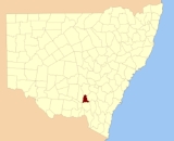
Clarendon County, New South Wales
Encyclopedia
Clarendon County is one of the 141 Cadastral divisions of New South Wales
. It contains the towns of Gundagai
, Junee
and Bethungra
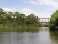
. The Murrumbidgee River
is the boundary to the south.
Clarendon County was named in honour of George William Frederick Villiers, 4th Earl Clarendon (1800-1870).
Cadastral divisions of New South Wales
Lands administrative divisions of New South Wales refers to the 141 counties within the Australian state of New South Wales, which are further subdivided into 7,459 parishes. There are also three Land Divisions, around 100 Land Districts, and several other types of districts as well as land boards...
. It contains the towns of Gundagai
Gundagai, New South Wales
Gundagai is a town in New South Wales, Australia. Although a small town, Gundagai is a popular topic for writers and has become a representative icon of a typical Australian country town...
, Junee
Junee, New South Wales
Junee is a medium sized town in the Riverina region of New South Wales, Australia. The town's prosperity and mixed services economy is based on a combination of agriculture, rail transport, light industry and government services, and in particular correctional services...
and Bethungra
Bethungra, New South Wales
Bethungra is a locality in Junee Shire in the South West Slopes region of New South Wales, Australia situated on the Olympic Way about 13 kilometres northeast of Illabo and 24 kilometres southwest of Cootamundra....
. The Murrumbidgee River
Murrumbidgee River
The Murrumbidgee River is a major river in the state of New South Wales, Australia, and the Australian Capital Territory . A major tributary of the Murray River, the Murrumbidgee flows in a west-northwesterly direction from the foot of Peppercorn Hill in the Fiery Range of the Snowy Mountains,...
is the boundary to the south.
Clarendon County was named in honour of George William Frederick Villiers, 4th Earl Clarendon (1800-1870).
Parishes within this county
A full list of parishes found within this county; their current LGA and mapping coordinates to the approximate centre of each location is as follows:| Parish | LGA | Coordinates |
|---|---|---|
| Bethungra Bethungra, New South Wales Bethungra is a locality in Junee Shire in the South West Slopes region of New South Wales, Australia situated on the Olympic Way about 13 kilometres northeast of Illabo and 24 kilometres southwest of Cootamundra.... |
Junee Shire Council | 34°43′54"S 147°50′04"E |
| Bilda | Junee Shire Council | 35°04′54"S 147°39′04"E |
| Billabung | Junee Shire Council | 34°47′54"S 147°48′04"E |
| Boree Boree Creek, New South Wales Boree Creek is a town in the Riverina district of New South Wales, Australia. The town is located south west of the state capital, Sydney and west of the regional centre, Wagga Wagga. Boree Creek is situated in the Urana Shire Local Government Area but is closer to the town of Lockhart... |
Junee Shire Council | 34°50′54"S 147°39′04"E |
| Bulgan | City of Wagga Wagga City of Wagga Wagga The Wagga Wagga City Council was formed from the amalgamation of City of Wagga Wagga with Mitchell and Kyeamba Shires in 1981. 22 December 2009, Wagga Wagga City Council announced that Phil Pinyon would be appointed as the General Manager of the Wagga Wagga City Council after Lyn Russell, who... |
34°57′54"S 147°20′04"E |
| Bute | Junee Shire Council | 34°35′54"S 147°46′04"E |
| Claris | Junee Shire Council | 34°59′54"S 147°40′04"E |
| Cooba | Junee Shire Council | 34°55′54"S 147°52′04"E |
| Eunanoreenya Eunanoreenya, New South Wales Eunanoreenya is a rural suburb of Wagga Wagga, New South Wales.... |
City of Wagga Wagga City of Wagga Wagga The Wagga Wagga City Council was formed from the amalgamation of City of Wagga Wagga with Mitchell and Kyeamba Shires in 1981. 22 December 2009, Wagga Wagga City Council announced that Phil Pinyon would be appointed as the General Manager of the Wagga Wagga City Council after Lyn Russell, who... |
35°03′54"S 147°29′04"E |
| Eurongilly Eurongilly, New South Wales Eurongilly is a locality in the central part of the Riverina and situated about 19 kilometres north west from Nangus and 21 kilometres south east from Junee.Clarendon Post Office opened on 1 January 1866, was renamed Eurongilly in 1886, and closed in 1926.... |
Junee Shire Council | 34°55′54"S 147°45′04"E |
| Gobbagombalin Gobbagombalin, New South Wales Gobbagombalin is a farming community in the central east part of the Riverina and a suburb of Wagga Wagga.. A portion of Gobbagombalin adjacent to Estella and to the North of Old Narrandera Road was rezoned for residential purposes under the Wagga Wagga Local Environmental Plan 2010 in July 2010,... |
City of Wagga Wagga City of Wagga Wagga The Wagga Wagga City Council was formed from the amalgamation of City of Wagga Wagga with Mitchell and Kyeamba Shires in 1981. 22 December 2009, Wagga Wagga City Council announced that Phil Pinyon would be appointed as the General Manager of the Wagga Wagga City Council after Lyn Russell, who... |
35°02′54"S 147°18′04"E |
| Gwynne | Junee Shire Council | 34°47′54"S 147°30′04"E |
| Houlaghan | Junee Shire Council | 34°43′40"S 147°32′43"E |
| Hurley | Junee Shire Council | 34°36′54"S 147°41′04"E |
| Ironbong | Junee Shire Council | 34°44′54"S 147°45′04"E |
| Ivor | Junee Shire Council | 34°44′54"S 147°40′04"E |
| Jeralgambeth | Junee Shire Council | 34°59′54"S 147°35′04"E |
| Junee Junee, New South Wales Junee is a medium sized town in the Riverina region of New South Wales, Australia. The town's prosperity and mixed services economy is based on a combination of agriculture, rail transport, light industry and government services, and in particular correctional services... |
Junee Shire Council | 34°47′54"S 147°33′04"E |
| Kimo | Gundagai Shire Council Gundagai Shire Council Gundagai Shire is a local government area in the Riverina region of New South Wales, Australia, on the Hume Highway. Gundagai was declared a Municipality in 1889, and Adjungbilly Shire Council created in 1906 to administer the district... |
35°02′54"S 148°00′04"E |
| Malebo Malebo, New South Wales Malebo is an unbounded neighbourhood in the locality of Euberta in the central east part of the Riverina. It is situated by road, about 10 km west of Wagga Wagga and 16 km east of Millwood.... |
Junee Shire Council | 34°55′54"S 147°23′04"E |
| Maror | Junee Shire Council | 34°50′54"S 147°28′04"E |
| Merrybundinah | Junee Shire Council | 34°51′54"S 147°48′04"E |
| Mitta Mitta Mitta Mitta, New South Wales Mitta Mitta is a farming community in the north eastern part of the Riverina. It is situated by road, about 30 kilometres south from Bethungra and 21 kilometres north east from Nangus... |
Junee Shire Council | 34°51′54"S 147°54′04"E |
| Nangus Nangus, New South Wales Nangus is a small country village on the Wagga Wagga to Gundagai Road on the north side of the Murrimbidgee river. From Nangus, Junee, Gundagai, Wantabadgery, Oura and Wagga Wagga are accessible. Nangus approximately 24 kilometres due west of Gundagai in the Riverina area of Australia and in... |
Gundagai Shire Council Gundagai Shire Council Gundagai Shire is a local government area in the Riverina region of New South Wales, Australia, on the Hume Highway. Gundagai was declared a Municipality in 1889, and Adjungbilly Shire Council created in 1906 to administer the district... |
35°00′54"S 147°57′04"E |
| North Gundagai | Gundagai Shire Council Gundagai Shire Council Gundagai Shire is a local government area in the Riverina region of New South Wales, Australia, on the Hume Highway. Gundagai was declared a Municipality in 1889, and Adjungbilly Shire Council created in 1906 to administer the district... |
35°00′54"S 148°04′04"E |
| North Wagga Wagga | City of Wagga Wagga City of Wagga Wagga The Wagga Wagga City Council was formed from the amalgamation of City of Wagga Wagga with Mitchell and Kyeamba Shires in 1981. 22 December 2009, Wagga Wagga City Council announced that Phil Pinyon would be appointed as the General Manager of the Wagga Wagga City Council after Lyn Russell, who... |
35°03′54"S 147°23′04"E |
| Oura Oura, New South Wales Oura is a town community in the central east part of the Riverina and situated about 15 kilometres north east from Wagga Wagga and 20 kilometres south west from Wantabadgery. At the 2006 census, Oura had a population of 380 people.... |
City of Wagga Wagga City of Wagga Wagga The Wagga Wagga City Council was formed from the amalgamation of City of Wagga Wagga with Mitchell and Kyeamba Shires in 1981. 22 December 2009, Wagga Wagga City Council announced that Phil Pinyon would be appointed as the General Manager of the Wagga Wagga City Council after Lyn Russell, who... |
35°03′54"S 147°33′04"E |
| Sebastopol Sebastopol, New South Wales Sebastopol is a village community in the north east part of the Riverina. It is situated by road, about 15 kilometres south from Temora and 19 kilometres north from Junee Reefs.The village is located by signage on the Olympic Highway... |
Temora Shire Council Temora Shire Council Temora Shire is a local government area in the Riverina region of New South Wales, Australia. It is on Burley Griffin Way.It includes the town of Temora and the small towns of Springdale, Sebastapol, Ariah Park, Gidginbung, Narraburra and Wallundry.... |
34°35′54"S 147°34′04"E |
| South Junee | Junee Shire Council | 34°53′54"S 147°31′04"E |
| Tenandra | Junee Shire Council | 34°59′54"S 147°50′04"E |
| Trevethin | Junee Shire Council | 34°40′54"S 147°40′04"E |
| Ulandra Ulandra Nature Reserve The Ulandra Nature Reserve is a 3930 hectare nature reserve approximately south-west of Cootamundra and south-east of the village of Bethungra, in New South Wales. The reserve is located on the western hills of the Southern Tablelands. The reserve's main feature is Mount Ulandra... |
Junee Shire Council | 34°45′54"S 147°54′04"E |
| Wallace | City of Wagga Wagga City of Wagga Wagga The Wagga Wagga City Council was formed from the amalgamation of City of Wagga Wagga with Mitchell and Kyeamba Shires in 1981. 22 December 2009, Wagga Wagga City Council announced that Phil Pinyon would be appointed as the General Manager of the Wagga Wagga City Council after Lyn Russell, who... |
34°57′54"S 147°28′04"E |
| Wantabadgery Wantabadgery, New South Wales Wantabadgery is a village community in the central eastern part of the Riverina and situated about 35 kilometres east from Wagga Wagga and 19 kilometres west from Nangus... |
Junee Shire Council | 34°59′54"S 147°45′04"E |
| Wantiool | Junee Shire Council | 34°54′54"S 147°39′04"E |
| Warre Warral | Junee Shire Council | 34°38′54"S 147°32′04"E |