

Moruya River
Encyclopedia
New South Wales
New South Wales is a state of :Australia, located in the east of the country. It is bordered by Queensland, Victoria and South Australia to the north, south and west respectively. To the east, the state is bordered by the Tasman Sea, which forms part of the Pacific Ocean. New South Wales...
, Australia
Australia
Australia , officially the Commonwealth of Australia, is a country in the Southern Hemisphere comprising the mainland of the Australian continent, the island of Tasmania, and numerous smaller islands in the Indian and Pacific Oceans. It is the world's sixth-largest country by total area...
. Its freshwater reaches are known as the Deua River
Deua River
The Deua River is the freshwater reaches of the Moruya River, an east coast drainage in southern New South Wales, Australia. The Deua River rises in rugged and thickly forested ranges south of Braidwood...
.
The headwaters of the Moruya River rise as the Deua River south of Braidwood
Braidwood, New South Wales
Braidwood is a town in the Southern Tablelands of New South Wales, Australia, in Palerang Shire. It is located on the busy Kings Highway linking Canberra to Batemans Bay on the coast. It is about 200 kilometres south west of Sydney and about 60 kilometres inland from the coast...
. The village of Araluen
Araluen, New South Wales
Araluen is a small town near Braidwood in the Southern Tablelands of New South Wales, Australia, in Palerang Council. It lies in the valley of Araluen creek, that joins the Deua River at roughly the mid point in its course. On Census night 2006, Araluen had a population of 215 people.The name...
lies in the upper valley of the river, and the site of gold mining in the late nineteenth century.
The town of Moruya
Moruya, New South Wales
Moruya is a small regional centre in New South Wales, Australia, situated on the Moruya River, approximately 300 kilometers south of Sydney. At the 2006 census, Moruya had a population of 10,278 people. The town relies predominantly on agriculture, aquaculture, and tourism...
is located on the lower, estuarine reaches of the river, about 10 kilometers from the sea. The river was previously navigable by coastal shipping to Moruya and was serviced by the Illawarra Steam Navigation Company
Illawarra Steam Navigation Company
The Illawarra Steam Navigation Company was a shipping company that serviced the south coast of New South Wales, Australia from 1858 to the early 1950s...
.
The Princes Highway
Princes Highway
The Princes Highway extends from Sydney to Port Augusta via the coast through the states of New South Wales, Victoria and South Australia, a distance of 1941 km or 1898 km via the former alignments of the highway ....
crosses the river at Moruya. The first bridge across the Moruya River was erected in 1876. Due to frequent flooding new bridges were erected in 1900 and 1945 and, most recently, in 1966.
The granite used to construct the facings of the pylons of the Sydney Harbour Bridge
Sydney Harbour Bridge
The Sydney Harbour Bridge is a steel through arch bridge across Sydney Harbour that carries rail, vehicular, bicycle and pedestrian traffic between the Sydney central business district and the North Shore. The dramatic view of the bridge, the harbour, and the nearby Sydney Opera House is an iconic...
was quarried from the banks of the Moruya River.
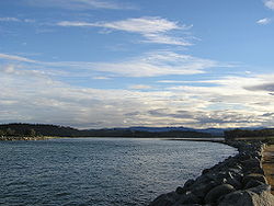
The river has a bar at its confluence with the Tasman Sea
Tasman Sea
The Tasman Sea is the large body of water between Australia and New Zealand, approximately across. It extends 2,800 km from north to south. It is a south-western segment of the South Pacific Ocean. The sea was named after the Dutch explorer Abel Janszoon Tasman, the first recorded European...
. The bar is dangerous to shipping and as a result of its hazards for smaller ships and because it prevented access by larger ones, the major settlement in the area was first developed at nearby Broulee
Broulee, New South Wales
Broulee is a town on the south coast of New South Wales between Batemans Bay and Moruya. In 2006, the town had a population of 1,292 people. Just off the beach is a Broulee Island, currently joined to the mainland, but in past years the connecting spit has been covered by water, at times a very ...
. In 1841 a flood cleared the bar and the town of Moruya, now accessible to shipping, developed at the expense of the settlement at Broulee despite later recurring problems with the bar, not least as it was the easist point to access the rich Araluen goldfields from the 1850s.
The Benandra, a wooden screw steamer operated by the Illawarra Steam Navigation Company to transport cargo, was lost on 25 March 1924 when it hit the sandspit near the bar. At least 1 person died.
The bar is now managed in part by a rock breakwall
Breakwater (structure)
Breakwaters are structures constructed on coasts as part of coastal defence or to protect an anchorage from the effects of weather and longshore drift.-Purposes of breakwaters:...
on the northern side of the river.
At the mouth of the river is the town of Moruya Heads.