
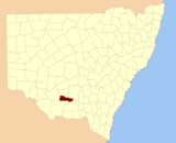
Boyd County, New South Wales
Encyclopedia
Boyd County is one of the 141 Cadastral divisions of New South Wales
. It contains the locality of Coleambally
. The Murrumbidgee River
is the northern boundary.
Boyd County was named in honour of Benjamin Boyd
, entrepreneur (1796-1851).
Cadastral divisions of New South Wales
Lands administrative divisions of New South Wales refers to the 141 counties within the Australian state of New South Wales, which are further subdivided into 7,459 parishes. There are also three Land Divisions, around 100 Land Districts, and several other types of districts as well as land boards...
. It contains the locality of Coleambally
Coleambally, New South Wales
Coleambally is a small town in the Riverina of New South Wales, Australia, in Murrumbidgee Shire.Coleambally is one of the newest towns in the state of New South Wales, officially opened in June 1968, with the Post Office opening on 1 April 1970...
. The Murrumbidgee River
Murrumbidgee River
The Murrumbidgee River is a major river in the state of New South Wales, Australia, and the Australian Capital Territory . A major tributary of the Murray River, the Murrumbidgee flows in a west-northwesterly direction from the foot of Peppercorn Hill in the Fiery Range of the Snowy Mountains,...
is the northern boundary.
Boyd County was named in honour of Benjamin Boyd
Benjamin Boyd
Benjamin Boyd was a Scottish-born Australian pioneer and entrepreneur.Boyd was a man of "an imposing personal appearance, fluent oratory, aristocratic connexions, and a fair share of commercial acuteness". Mrs Georgiana McCrae, with whom he had dinner when he first came to Port Phillip, looked at...
, entrepreneur (1796-1851).
Parishes within this county
A full list of parishes found within this county; their current LGA and mapping coordinates to the approximate centre of each location is as follows:| Parish | LGA | Coordinates |
|---|---|---|
| Argoon | Murrumbidgee Shire Council | 34°50′54"S 145°54′04"E |
| Banandra | Murrumbidgee Shire Council | 34°45′54"S 146°10′04"E |
| Boona | Murrumbidgee Shire Council | 34°46′54"S 145°58′04"E |
| Boyd | Murrumbidgee Shire Council | 34°47′54"S 145°22′04"E |
| Burt | Leeton Shire Council Leeton Shire Council Leeton Shire is a local government area in the Riverina region of New South Wales, Australia and in the Murrumbidgee Irrigation Area. It is on the Murrumbidgee River.... |
34°39′54"S 146°16′04"E |
| Cararbury | Murrumbidgee Shire Council | 34°36′54"S 145°48′04"E |
| Clifford | Murrumbidgee Shire Council | 34°40′54"S 145°40′04"E |
| Coleambally Coleambally, New South Wales Coleambally is a small town in the Riverina of New South Wales, Australia, in Murrumbidgee Shire.Coleambally is one of the newest towns in the state of New South Wales, officially opened in June 1968, with the Post Office opening on 1 April 1970... |
Murrumbidgee Shire Council | 34°47′54"S 145°47′04"E |
| Dow | Murrumbidgee Shire Council | 34°39′54"S 145°35′04"E |
| Duderbang | Murrumbidgee Shire Council | 34°41′54"S 145°47′04"E |
| Eilginbah | Murrumbidgee Shire Council | 34°33′54"S 145°25′04"E |
| Eulo | Murrumbidgee Shire Council | 34°45′54"S 146°04′04"E |
| Eunanbrennan | Murrumbidgee Shire Council | 34°31′54"S 145°40′04"E |
| Gidgell | Murrumbidgee Shire Council | 34°51′54"S 146°05′04"E |
| Glengalla | Murrumbidgee Shire Council | 34°44′54"S 145°23′04"E |
| Gumblebogie | Murrumbidgee Shire Council | 34°47′54"S 145°33′04"E |
| Gundadaline | Murrumbidgee Shire Council | 34°40′54"S 145°31′04"E |
| Howell | Narrandera Shire Council Narrandera Shire Council Narrandera Shire is a local government area in New South Wales, Australia in the Riverina region. It is on the Sturt and Newell Highways.The Shire includes the town of Narrandera and the villages of Grong Grong, Binya and Barellan.... |
34°49′54"S 146°13′04"E |
| Jurambula | Murrumbidgee Shire Council | 34°39′54"S 146°10′04"E |
| Kabarabarabejal | Murrumbidgee Shire Council | 34°47′54"S 145°16′04"E |
| Macleay | Murrumbidgee Shire Council | 34°38′54"S 145°24′04"E |
| Maley | Murrumbidgee Shire Council | 34°47′54"S 145°40′04"E |
| Mulberrygong | Murrumbidgee Shire Council | 34°31′54"S 145°18′04"E |
| Mulburruga | Murrumbidgee Shire Council | 34°28′54"S 145°25′04"E |
| Mycotha | Murrumbidgee Shire Council | 34°45′54"S 145°54′04"E |
| Oolambeyan | Murrumbidgee Shire Council | 34°41′54"S 145°16′04"E |
| Ourendumbee | Narrandera Shire Council Narrandera Shire Council Narrandera Shire is a local government area in New South Wales, Australia in the Riverina region. It is on the Sturt and Newell Highways.The Shire includes the town of Narrandera and the villages of Grong Grong, Binya and Barellan.... |
34°44′54"S 146°16′04"E |
| Peter | Murrumbidgee Shire Council | 34°49′54"S 145°48′04"E |
| Puckinevvy | Murrumbidgee Shire Council | 34°35′54"S 145°32′04"E |
| Singorambah | Murrumbidgee Shire Council | 34°29′54"S 145°37′04"E |
| Toganmain | Murrumbidgee Shire Council | 34°28′54"S 145°31′04"E |
| Tubbo | Murrumbidgee Shire Council | 34°39′54"S 146°05′04"E |
| Ugobit | Murrumbidgee Shire Council | 34°41′54"S 145°53′04"E |
| Uri | Murrumbidgee Shire Council | 34°36′54"S 145°54′04"E |
| Uroly | Leeton Shire Council Leeton Shire Council Leeton Shire is a local government area in the Riverina region of New South Wales, Australia and in the Murrumbidgee Irrigation Area. It is on the Murrumbidgee River.... |
34°41′54"S 146°20′04"E |
| Waddaduri | Murrumbidgee Shire Council | 34°34′54"S 145°36′04"E |
| Waddi Waddi, New South Wales Waddi is a village community in the central part of the Riverina on the Sturt Highway. It is situated by road, about 2 kilometres south from Darlington Point and 29 kilometres north from Coleambally.-Notes and references:... |
Murrumbidgee Shire Council | 34°40′54"S 145°58′04"E |
| Wangabawgul | Murrumbidgee Shire Council | 34°46′54"S 145°29′04"E |
| Wolseley | Murrumbidgee Shire Council | 34°36′54"S 145°18′04"E |