
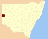
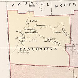
Yancowinna County, New South Wales
Encyclopedia
Cadastral divisions of New South Wales
Lands administrative divisions of New South Wales refers to the 141 counties within the Australian state of New South Wales, which are further subdivided into 7,459 parishes. There are also three Land Divisions, around 100 Land Districts, and several other types of districts as well as land boards...
. It contains the city of Broken Hill
Broken Hill, New South Wales
-Geology:Broken Hill's massive orebody, which formed about 1,800 million years ago, has proved to be among the world's largest silver-lead-zinc mineral deposits. The orebody is shaped like a boomerang plunging into the earth at its ends and outcropping in the centre. The protruding tip of the...
and village of Silverton
Silverton, New South Wales
Silverton is a small village at the far west of New South Wales, Australia, 25 kilometres north-west of Broken Hill. At the 2006 census, Silverton had a population of 89 people....
.
Some New South Wales industrial relations laws have excluded the county of Yancowinna. The county is also the only part of New South Wales which is in the same timezone as South Australia
South Australia
South Australia is a state of Australia in the southern central part of the country. It covers some of the most arid parts of the continent; with a total land area of , it is the fourth largest of Australia's six states and two territories.South Australia shares borders with all of the mainland...
(+9.5 rather than +10).
The name Yancowinna is believed to be derived from a local Aboriginal
Indigenous Australians
Indigenous Australians are the original inhabitants of the Australian continent and nearby islands. The Aboriginal Indigenous Australians migrated from the Indian continent around 75,000 to 100,000 years ago....
word and is also the name of the location within the county of Yancowinna Glen.
ParishParishA parish is a territorial unit historically under the pastoral care and clerical jurisdiction of one parish priest, who might be assisted in his pastoral duties by a curate or curates - also priests but not the parish priest - from a more or less central parish church with its associated organization...
es within this county
A full list of parishes found within this county; their current LGA and mapping coordinates to the approximate centre of each location is as follows:| Parish | LGA | Coordinates |
|---|---|---|
| Albert | Unincorporated | 32°00′54"S 141°08′29"E |
| Aldborough | Unincorporated | 32°14′09"S 141°51′49"E |
| Alma | Unincorporated | 32°00′29"S 141°21′49"E |
| Barrier | Unincorporated | 32°09′24"S 141°38′10"E |
| Bolaira | Unincorporated | 31°57′47"S 141°32′30"E |
| Bomangaldy | Unincorporated | 31°49′58"S 141°11′11"E |
| Bray | Unincorporated | 31°57′37"S 141°15′19"E |
| Cambellia | Unincorporated | unknown |
| Carrington | Unincorporated | 31°49′58"S 141°04′34"E |
| Cathcart | Unincorporated | 31°47′09"S 141°35′28"E |
| Coombarra | Unincorporated | 32°09′22"S 141°28′29"E |
| Coonbaralla | Unincorporated | 32°03′22"S 141°49′46"E |
| Dhoon | Unincorporated | 32°07′55"S 141°08′39"E |
| Edgar | Unincorporated | 32°03′01"S 141°14′28"E |
| Elti | Unincorporated | 31°42′07"S 141°05′33"E |
| Fairy Hill | Unincorporated | 31°39′52"S 141°47′55"E |
| Farmcoat | Unincorporated | 32°05′13"S 141°40′35"E |
| Hughes | Unincorporated | 32°12′09"S 141°25′49"E |
| Inkerman | Unincorporated | 31°52′21"S 141°54′45"E |
| Jamieson | Unincorporated | 31°53′33"S 141°04′35"E |
| Lewis | Unincorporated | 31°45′14"S 141°24′00"E |
| Maharatta | Unincorporated | 31°51′14"S 141°46′46"E |
| Matong | Unincorporated | 31°49′05"S 141°50′09"E |
| Meadows | Unincorporated | 31°39′39"S 141°05′32"E |
| Moorkaie | Unincorporated | 31°49′09"S 141°38′47"E |
| Mount Gipps | Unincorporated | 31°46′30"S 141°29′16"E |
| Mundi Mundi | Unincorporated | 31°44′19"S 141°13′24"E |
| Myalla | Unincorporated | 31°44′04"S 141°55′39"E |
| Nadbuck | Unincorporated | 31°56′45"S 141°21′41"E |
| Naradin | Unincorporated | 31°53′06"S 141°21′39"E |
| Narran | Unincorporated | 32°07′38"S 141°47′26"E |
| Ophara | Unincorporated | 32°07′55"S 141°02′50"E |
| Picton | Unincorporated | 31°54′34"S 141°28′11"E |
| Purnamoota | Unincorporated | 31°35′48"S 141°27′50"E |
| Redan | Unincorporated | 32°14′30"S 141°44′56"E |
| Robe | Unincorporated | 31°39′21"S 141°21′11"E |
| Sebastopol | Unincorporated | 32°03′39"S 141°33′25"E |
| Sentinel | Unincorporated | 32°10′36"S 141°14′49"E |
| Soudan | Unincorporated | 32°05′14"S 141°26′11"E |
| Stephen | Unincorporated | 31°48′38"S 141°22′04"E |
| Stratford | Unincorporated | 32°02′21"S 141°42′30"E |
| Tara | Unincorporated | 31°54′39"S 141°37′29"E |
| Thackaringa | Unincorporated | 31°57′42"S 141°06′21"E |
| Umberumberka | Unincorporated | 31°50′07"S 141°16′29"E |
| Victoria | Unincorporated | 32°04′16"S 141°02′47"E |
| Waukeroo | Unincorporated | 31°41′05"S 141°33′48"E |
| Yancowinna East | Unincorporated | 31°38′59"S 141°54′54"E |
| Yancowinna North | Unincorporated | 31°39′40"S 141°40′49"E |
| Yancowinna | Unincorporated | 31°45′29"S 141°43′04"E |
| Yangalla | Unincorporated | 31°36′56"S 141°14′23"E |