
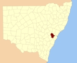
Cook County, New South Wales
Encyclopedia
Nineteen Counties
The Nineteen Counties were the limits of location in the colony of New South Wales defined by the Governor of New South Wales Sir Ralph Darling in 1826 in accordance with a government order from Lord Bathurst, the secretary of State. Counties had been used since the first year of settlement, with...
in New South Wales
New South Wales
New South Wales is a state of :Australia, located in the east of the country. It is bordered by Queensland, Victoria and South Australia to the north, south and west respectively. To the east, the state is bordered by the Tasman Sea, which forms part of the Pacific Ocean. New South Wales...
and is now one of the 141 Cadastral divisions of New South Wales
Cadastral divisions of New South Wales
Lands administrative divisions of New South Wales refers to the 141 counties within the Australian state of New South Wales, which are further subdivided into 7,459 parishes. There are also three Land Divisions, around 100 Land Districts, and several other types of districts as well as land boards...
. It includes the area to the west of Sydney in the Blue Mountains, between the Colo River
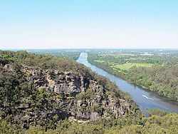
Colo River
The Colo River is a river in New South Wales, Australia.The Colo River begins at the confluence of the Wolgan River and the Capertee River, which respectively drain the Wolgan and Capertee Valleys north of Lithgow. The river flows eastwards and then south through a deep gorge in the northern...
in the north, and the Coxs River in the south and west, encompassing Lithgow
Lithgow, New South Wales
Lithgow is a city in the Central Tablelands of New South Wales, Australia and is the centre of the local political division City of Lithgow. It is located in a mountain valley named Lithgow's Valley by John Oxley in honour of William Lithgow, the first Auditor-General of New South Wales.Lithgow is...
, Mount Victoria
Mount Victoria, New South Wales
Mount Victoria is a small township in the Blue Mountains of New South Wales, Australia. It is the westernmost village in the City of Blue Mountains, located approximately 120 kilometres via road from Sydney and 1043 metres above sea-level...
, Katoomba
Katoomba, New South Wales
Katoomba is the chief town of the City of Blue Mountains in New South Wales, Australia and the administrative headquarters of Blue Mountains City Council. It is on the Great Western Highway 110 kilometres west of Sydney and 39 kilometres south-east of Lithgow. Katoomba railway station is on the...
, Wentworth Falls
Wentworth Falls, New South Wales
Wentworth Falls is a town in the Blue Mountains, New South Wales located 100 kilometres west of Sydney, and about 8 kilometres east of Katoomba, Australia on the Great Western Highway, with a Wentworth Falls railway station on the Main Western line. The town is situated at an elevation of...
, Lawson
Lawson, New South Wales
Lawson is a town in the Blue Mountains area of New South Wales, Australia. It is located on the Great Western Highway between Hazelbrook in the north east and Bullaburra in the west. At the 2006 census, Lawson had a population of 2,419 people. It has a station on the Main Western line...
and most of the other towns in the Blue Mountains. The Nepean River
Nepean River
The Nepean River is a river in the coastal region of New South Wales, Australia.The headwaters of the Nepean River rise near Robertson, about 100 kilometres south of Sydney and about 15 kilometres from the coast. The river flows north in an unpopulated water catchment area into Nepean Dam, which...
is the border to the east. Before 1834, the area was part of the Westmoreland, Northumberland and Roxburgh counties.http://www.nla.gov.au/apps/cdview?pi=nla.map-nk5976-sd
Cook County was named in honour of the navigator James Cook
James Cook
Captain James Cook, FRS, RN was a British explorer, navigator and cartographer who ultimately rose to the rank of captain in the Royal Navy...
(1728-1779). The Electoral district of Cook and Westmoreland
Electoral district of Cook and Westmoreland
Cook and Westmoreland was an electoral district of the Legislative Assembly in the Australian state of New South Wales in the first and second Parliaments , named after Cook and Westmoreland counties in the Blue Mountains, Lithgow and Oberon areas. It was largely replaced by Hartley...
was the first state electoral district for the area, between 1856 and 1859.
Parishes within this county
A full list of parishes found within this county; their current LGA and mapping coordinates to the approximate centre of each location is as follows:| Parish | LGA | Coordinates |
|---|---|---|
| Barton | City of Lithgow City of Lithgow Lithgow is a Local Government Area in New South Wales, Australia that includes Lithgow and its surrounding area. It is on the Great Western Highway and the Main Western railway line.- Demographics :According to the , there:... |
33°14′54"S 150°15′04"E |
| Bilpin Bilpin, New South Wales Bilpin is a small town on the historic Bells Line of Road in the City of Hawkesbury local government area in the Blue Mountains, west of Sydney, New South Wales. In 2006, the town had a population of 843 people.Bilpin is known as "Land of the Mountain Apple"... |
City of Hawkesbury City of Hawkesbury The City of Hawkesbury is a Local Government Area of New South Wales, Australia, part of which is at the fringe of the Sydney metropolitan area, about 50 kilometres north-west of the Sydney central business district... |
33°29′54"S 150°30′04"E |
| Blackheath Blackheath, New South Wales Blackheath is a small town located near the top of the Blue Mountains in New South Wales, Australia, 120 kilometres west north west of Sydney and 11 kilometres northwest of Katoomba. In 2006, Blackheath had a population of 4,177 people... |
City of Blue Mountains City of Blue Mountains The City of Blue Mountains is a local government area of New South Wales, Australia, governed by the Blue Mountains City Council. The city is located in the Blue Mountains range west of Sydney.-Demographics:... |
33°38′54"S 150°19′04"E |
| Bowen | City of Blue Mountains City of Blue Mountains The City of Blue Mountains is a local government area of New South Wales, Australia, governed by the Blue Mountains City Council. The city is located in the Blue Mountains range west of Sydney.-Demographics:... |
33°25′54"S 150°30′04"E |
| Burralow | City of Hawkesbury City of Hawkesbury The City of Hawkesbury is a Local Government Area of New South Wales, Australia, part of which is at the fringe of the Sydney metropolitan area, about 50 kilometres north-west of the Sydney central business district... |
33°33′54"S 150°35′04"E |
| Capertee Capertee, New South Wales Capertee is a village 45km north of Lithgow, New South Wales, Australia located on an elevated site above the Capertee Valley. In 2006, the town had a population of 72 people. Situated on the Castlereagh Highway between Lithgow and Mudgee, Capertee is surrounded by National Parks and grazing land... |
City of Lithgow City of Lithgow Lithgow is a Local Government Area in New South Wales, Australia that includes Lithgow and its surrounding area. It is on the Great Western Highway and the Main Western railway line.- Demographics :According to the , there:... |
33°11′54"S 150°24′04"E |
| Clwydd | City of Lithgow City of Lithgow Lithgow is a Local Government Area in New South Wales, Australia that includes Lithgow and its surrounding area. It is on the Great Western Highway and the Main Western railway line.- Demographics :According to the , there:... |
33°29′54"S 150°17′04"E |
| Colo Colo Heights, New South Wales Colo Heights is a village of Sydney, in the state of New South Wales, Australia. It is located in the City of Hawkesbury north-west of Colo.The current population is 410 .... |
City of Hawkesbury City of Hawkesbury The City of Hawkesbury is a Local Government Area of New South Wales, Australia, part of which is at the fringe of the Sydney metropolitan area, about 50 kilometres north-west of the Sydney central business district... |
33°25′54"S 150°46′04"E |
| Cooba | City of Blue Mountains City of Blue Mountains The City of Blue Mountains is a local government area of New South Wales, Australia, governed by the Blue Mountains City Council. The city is located in the Blue Mountains range west of Sydney.-Demographics:... |
33°52′54"S 150°27′04"E |
| Cook | City of Lithgow City of Lithgow Lithgow is a Local Government Area in New South Wales, Australia that includes Lithgow and its surrounding area. It is on the Great Western Highway and the Main Western railway line.- Demographics :According to the , there:... |
33°17′46"S 150°13′42"E |
| Coomassie | City of Blue Mountains City of Blue Mountains The City of Blue Mountains is a local government area of New South Wales, Australia, governed by the Blue Mountains City Council. The city is located in the Blue Mountains range west of Sydney.-Demographics:... |
33°38′54"S 150°34′04"E |
| Cox | City of Lithgow City of Lithgow Lithgow is a Local Government Area in New South Wales, Australia that includes Lithgow and its surrounding area. It is on the Great Western Highway and the Main Western railway line.- Demographics :According to the , there:... |
33°19′54"S 150°05′04"E |
| Currency | City of Hawkesbury City of Hawkesbury The City of Hawkesbury is a Local Government Area of New South Wales, Australia, part of which is at the fringe of the Sydney metropolitan area, about 50 kilometres north-west of the Sydney central business district... |
33°32′54"S 150°45′04"E |
| Falnash | City of Lithgow City of Lithgow Lithgow is a Local Government Area in New South Wales, Australia that includes Lithgow and its surrounding area. It is on the Great Western Highway and the Main Western railway line.- Demographics :According to the , there:... |
33°22′54"S 149°59′04"E |
| Gindantherie | City of Lithgow City of Lithgow Lithgow is a Local Government Area in New South Wales, Australia that includes Lithgow and its surrounding area. It is on the Great Western Highway and the Main Western railway line.- Demographics :According to the , there:... |
33°09′54"S 150°15′04"E |
| Goollooinboin | City of Lithgow City of Lithgow Lithgow is a Local Government Area in New South Wales, Australia that includes Lithgow and its surrounding area. It is on the Great Western Highway and the Main Western railway line.- Demographics :According to the , there:... |
33°10′54"S 150°08′04"E |
| Govett | City of Lithgow City of Lithgow Lithgow is a Local Government Area in New South Wales, Australia that includes Lithgow and its surrounding area. It is on the Great Western Highway and the Main Western railway line.- Demographics :According to the , there:... |
33°14′54"S 150°26′04"E |
| Govett South | City of Lithgow City of Lithgow Lithgow is a Local Government Area in New South Wales, Australia that includes Lithgow and its surrounding area. It is on the Great Western Highway and the Main Western railway line.- Demographics :According to the , there:... |
33°17′54"S 150°23′04"E |
| Grose | City of Blue Mountains City of Blue Mountains The City of Blue Mountains is a local government area of New South Wales, Australia, governed by the Blue Mountains City Council. The city is located in the Blue Mountains range west of Sydney.-Demographics:... |
33°35′54"S 150°30′04"E |
| Hartley Hartley, New South Wales Hartley is a historical village in New South Wales, Australia, in the City of Lithgow, located approximately 150 kilometres west of Sydney. It is below the western escarpment of the Blue Mountains.... |
City of Lithgow City of Lithgow Lithgow is a Local Government Area in New South Wales, Australia that includes Lithgow and its surrounding area. It is on the Great Western Highway and the Main Western railway line.- Demographics :According to the , there:... |
33°33′54"S 150°14′04"E |
| Irvine | City of Hawkesbury City of Hawkesbury The City of Hawkesbury is a Local Government Area of New South Wales, Australia, part of which is at the fringe of the Sydney metropolitan area, about 50 kilometres north-west of the Sydney central business district... |
33°31′54"S 150°23′04"E |
| Jamison | City of Blue Mountains City of Blue Mountains The City of Blue Mountains is a local government area of New South Wales, Australia, governed by the Blue Mountains City Council. The city is located in the Blue Mountains range west of Sydney.-Demographics:... |
33°42′54"S 150°22′04"E |
| Kanimbla | City of Lithgow City of Lithgow Lithgow is a Local Government Area in New South Wales, Australia that includes Lithgow and its surrounding area. It is on the Great Western Highway and the Main Western railway line.- Demographics :According to the , there:... |
33°39′54"S 150°13′04"E |
| Kedumba | City of Blue Mountains City of Blue Mountains The City of Blue Mountains is a local government area of New South Wales, Australia, governed by the Blue Mountains City Council. The city is located in the Blue Mountains range west of Sydney.-Demographics:... |
33°49′54"S 150°22′04"E |
| Kurrajong | City of Hawkesbury City of Hawkesbury The City of Hawkesbury is a Local Government Area of New South Wales, Australia, part of which is at the fringe of the Sydney metropolitan area, about 50 kilometres north-west of the Sydney central business district... |
33°33′54"S 150°39′04"E |
| Lett | City of Lithgow City of Lithgow Lithgow is a Local Government Area in New South Wales, Australia that includes Lithgow and its surrounding area. It is on the Great Western Highway and the Main Western railway line.- Demographics :According to the , there:... |
33°31′54"S 150°09′04"E |
| Lidsdale | City of Lithgow City of Lithgow Lithgow is a Local Government Area in New South Wales, Australia that includes Lithgow and its surrounding area. It is on the Great Western Highway and the Main Western railway line.- Demographics :According to the , there:... |
33°27′54"S 150°02′04"E |
| Linden | City of Blue Mountains City of Blue Mountains The City of Blue Mountains is a local government area of New South Wales, Australia, governed by the Blue Mountains City Council. The city is located in the Blue Mountains range west of Sydney.-Demographics:... |
33°44′54"S 150°28′04"E |
| Magdala | City of Blue Mountains City of Blue Mountains The City of Blue Mountains is a local government area of New South Wales, Australia, governed by the Blue Mountains City Council. The city is located in the Blue Mountains range west of Sydney.-Demographics:... |
33°44′54"S 150°33′04"E |
| Marrangaroo | City of Lithgow City of Lithgow Lithgow is a Local Government Area in New South Wales, Australia that includes Lithgow and its surrounding area. It is on the Great Western Highway and the Main Western railway line.- Demographics :According to the , there:... |
33°25′54"S 150°10′04"E |
| Meehan | City of Hawkesbury City of Hawkesbury The City of Hawkesbury is a Local Government Area of New South Wales, Australia, part of which is at the fringe of the Sydney metropolitan area, about 50 kilometres north-west of the Sydney central business district... |
33°29′54"S 150°48′04"E |
| Megalong | City of Blue Mountains City of Blue Mountains The City of Blue Mountains is a local government area of New South Wales, Australia, governed by the Blue Mountains City Council. The city is located in the Blue Mountains range west of Sydney.-Demographics:... |
33°44′54"S 150°15′04"E |
| Merroo | City of Hawkesbury City of Hawkesbury The City of Hawkesbury is a Local Government Area of New South Wales, Australia, part of which is at the fringe of the Sydney metropolitan area, about 50 kilometres north-west of the Sydney central business district... |
33°29′54"S 150°40′04"E |
| Mouin | City of Blue Mountains City of Blue Mountains The City of Blue Mountains is a local government area of New South Wales, Australia, governed by the Blue Mountains City Council. The city is located in the Blue Mountains range west of Sydney.-Demographics:... |
33°51′54"S 150°15′04"E |
| Nepean | City of Hawkesbury City of Hawkesbury The City of Hawkesbury is a Local Government Area of New South Wales, Australia, part of which is at the fringe of the Sydney metropolitan area, about 50 kilometres north-west of the Sydney central business district... |
33°38′54"S 150°38′04"E |
| Rock Hill | City of Lithgow City of Lithgow Lithgow is a Local Government Area in New South Wales, Australia that includes Lithgow and its surrounding area. It is on the Great Western Highway and the Main Western railway line.- Demographics :According to the , there:... |
33°22′35"S 150°18′24"E |
| Strathdon | City of Penrith City of Penrith The City of Penrith is a Local Government Area in Sydney, located about west of Sydney's central business district.- History :The Municipality of Penrith was incorporated on 12 May 1871 under the Municipalities Act 1858. On 3 March 1890, St Marys was separately incorporated, and on 26 July 1893... |
33°44′54"S 150°38′04"E |
| Warragamba | City of Blue Mountains City of Blue Mountains The City of Blue Mountains is a local government area of New South Wales, Australia, governed by the Blue Mountains City Council. The city is located in the Blue Mountains range west of Sydney.-Demographics:... |
33°50′54"S 150°32′04"E |
| Wheeny | City of Hawkesbury City of Hawkesbury The City of Hawkesbury is a Local Government Area of New South Wales, Australia, part of which is at the fringe of the Sydney metropolitan area, about 50 kilometres north-west of the Sydney central business district... |
33°29′54"S 150°35′04"E |
| Wilberforce Wilberforce, New South Wales Wilberforce is a small town in New South Wales, Australia, in the local government area of the City of Hawkesbury. It is just beyond the outer suburbs of north-west Sydney and lies on the western bank of the Hawkesbury River.-History:... |
City of Hawkesbury City of Hawkesbury The City of Hawkesbury is a Local Government Area of New South Wales, Australia, part of which is at the fringe of the Sydney metropolitan area, about 50 kilometres north-west of the Sydney central business district... |
33°31′24"S 150°51′04"E |
| Wolgan | City of Lithgow City of Lithgow Lithgow is a Local Government Area in New South Wales, Australia that includes Lithgow and its surrounding area. It is on the Great Western Highway and the Main Western railway line.- Demographics :According to the , there:... |
33°14′54"S 150°10′04"E |
| Wollangambe | City of Lithgow City of Lithgow Lithgow is a Local Government Area in New South Wales, Australia that includes Lithgow and its surrounding area. It is on the Great Western Highway and the Main Western railway line.- Demographics :According to the , there:... |
33°29′54"S 150°20′04"E |
| Wollangambe North | City of Lithgow City of Lithgow Lithgow is a Local Government Area in New South Wales, Australia that includes Lithgow and its surrounding area. It is on the Great Western Highway and the Main Western railway line.- Demographics :According to the , there:... |
33°21′24"S 150°24′04"E |
| Wollemi | City of Hawkesbury City of Hawkesbury The City of Hawkesbury is a Local Government Area of New South Wales, Australia, part of which is at the fringe of the Sydney metropolitan area, about 50 kilometres north-west of the Sydney central business district... |
33°14′54"S 150°30′04"E |
| Woodford Woodford, New South Wales Woodford is a village in the Blue Mountains in New South Wales, Australia, approximately 90 kilometres west of Sydney. Its elevation is above sea level. It is situated on the Great Western Highway and has a railway station on the Main Western railway line served by CityRail's Blue Mountains... |
City of Blue Mountains City of Blue Mountains The City of Blue Mountains is a local government area of New South Wales, Australia, governed by the Blue Mountains City Council. The city is located in the Blue Mountains range west of Sydney.-Demographics:... |
33°39′54"S 150°30′04"E |