
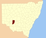
Waljeers County, New South Wales
Encyclopedia
Waljeers County is one of the 141 Cadastral divisions of New South Wales
. It contains the town of Booligal
.
The name Waljeers is believed to be derived from a local Aboriginal
word.
Lake Waljeers is one of largest lakes located north of the Lachlan River and the river crossing at Thellangering.
Cadastral divisions of New South Wales
Lands administrative divisions of New South Wales refers to the 141 counties within the Australian state of New South Wales, which are further subdivided into 7,459 parishes. There are also three Land Divisions, around 100 Land Districts, and several other types of districts as well as land boards...
. It contains the town of Booligal
Booligal, New South Wales
Booligal is a village in the Riverina area of western New South Wales , Australia. It is located on the Cobb Highway, on the Lachlan River north of Hay...
.
The name Waljeers is believed to be derived from a local Aboriginal
Indigenous Australians
Indigenous Australians are the original inhabitants of the Australian continent and nearby islands. The Aboriginal Indigenous Australians migrated from the Indian continent around 75,000 to 100,000 years ago....
word.
Lake Waljeers is one of largest lakes located north of the Lachlan River and the river crossing at Thellangering.
Parishes within this county
A full list of parishes found within this county; their current LGA and mapping coordinates to the approximate centre of each location is as follows:| Parish | LGA | Coordinates |
|---|---|---|
| Abbotsford | Central Darling Shire Central Darling Shire Central Darling Shire is a Local Government Area in the Far West of New South Wales, Australia on the Barrier Highway. Central Darling Shire was constituted in 1959 and it is the largest Local Government Area in New South Wales.-Incomes:... |
33°13′50"S 144°19′26"E |
| Alma | Balranald Shire | 33°23′34"S 144°16′18"E |
| Annan | Carrathool Shire Carrathool Shire Carrathool Shire is a Local Government Area in the Far West of New South Wales on the Mid-Western Highway and north of the Sturt Highway.The largest town is Hillston and the council seat is Goolgowi... |
33°21′04"S 144°39′15"E |
| Arrawatta | Balranald Shire | 33°43′41"S 144°28′14"E |
| Avondale | Carrathool Shire Carrathool Shire Carrathool Shire is a Local Government Area in the Far West of New South Wales on the Mid-Western Highway and north of the Sturt Highway.The largest town is Hillston and the council seat is Goolgowi... |
33°24′02"S 144°25′43"E |
| Benanimie | Hay Shire | 33°51′50"S 144°49′35"E |
| Billabong | Carrathool Shire Carrathool Shire Carrathool Shire is a Local Government Area in the Far West of New South Wales on the Mid-Western Highway and north of the Sturt Highway.The largest town is Hillston and the council seat is Goolgowi... |
33°20′21"S 144°25′52"E |
| Boondara | Carrathool Shire Carrathool Shire Carrathool Shire is a Local Government Area in the Far West of New South Wales on the Mid-Western Highway and north of the Sturt Highway.The largest town is Hillston and the council seat is Goolgowi... |
33°17′23"S 144°39′13"E |
| Brassbutt | Balranald Shire | 34°07′21"S 144°23′39"E |
| Buckonyong | Balranald Shire | 34°06′37"S 144°09′18"E |
| Bulgarbugerygam | Balranald Shire | 33°42′33"S 144°14′07"E |
| Bullogal | Balranald Shire | 33°55′09"S 144°31′18"E |
| Bungarry | Balranald Shire | 34°03′30"S 144°17′00"E |
| Campbell | Carrathool Shire Carrathool Shire Carrathool Shire is a Local Government Area in the Far West of New South Wales on the Mid-Western Highway and north of the Sturt Highway.The largest town is Hillston and the council seat is Goolgowi... |
33°29′14"S 144°30′18"E |
| Carngham | Hay Shire | 33°32′02"S 144°37′36"E |
| Corrong | Balranald Shire | 34°09′20"S 144°29′39"E |
| Culparling | Balranald Shire | 33°30′33"S 144°15′37"E |
| Culpataro | Balranald Shire | 33°37′36"S 144°23′51"E |
| Dimboola | Balranald Shire | 33°57′34"S 144°28′54"E |
| Ellisland | Balranald Shire | 33°16′40"S 144°18′56"E |
| Goona Warra | Hay Shire | 33°59′57"S 144°39′07"E |
| Gregory | Balranald Shire | 33°56′28"S 144°10′41"E |
| Howatson | Carrathool Shire Carrathool Shire Carrathool Shire is a Local Government Area in the Far West of New South Wales on the Mid-Western Highway and north of the Sturt Highway.The largest town is Hillston and the council seat is Goolgowi... |
33°20′35"S 144°46′29"E |
| Kingswell | Hay Shire | 33°34′27"S 144°44′50"E |
| Lagan | Balranald Shire | 34°05′09"S 144°23′59"E |
| Largs | Carrathool Shire Carrathool Shire Carrathool Shire is a Local Government Area in the Far West of New South Wales on the Mid-Western Highway and north of the Sturt Highway.The largest town is Hillston and the council seat is Goolgowi... |
33°21′03"S 144°32′01"E |
| Larnaca | Hay Shire | 33°35′46"S 144°34′53"E |
| Lowan | Central Darling Shire Central Darling Shire Central Darling Shire is a Local Government Area in the Far West of New South Wales, Australia on the Barrier Highway. Central Darling Shire was constituted in 1959 and it is the largest Local Government Area in New South Wales.-Incomes:... |
33°14′09"S 144°29′03"E |
| Marowie | Balranald Shire | 33°52′18"S 144°26′53"E |
| Massie | Hay Shire | 33°42′56"S 144°44′18"E |
| Matamong | Balranald Shire | 34°03′36"S 144°29′21"E |
| Mekai | Carrathool Shire Carrathool Shire Carrathool Shire is a Local Government Area in the Far West of New South Wales on the Mid-Western Highway and north of the Sturt Highway.The largest town is Hillston and the council seat is Goolgowi... |
33°22′51"S 144°45′57"E |
| Merrimajeel | Hay Shire | 33°55′29"S 144°37′39"E |
| Moodarnong | Hay Shire | 33°49′29"S 144°48′57"E |
| Mossgiel | Central Darling Shire Central Darling Shire Central Darling Shire is a Local Government Area in the Far West of New South Wales, Australia on the Barrier Highway. Central Darling Shire was constituted in 1959 and it is the largest Local Government Area in New South Wales.-Incomes:... |
33°10′56"S 144°35′50"E |
| Mulloga | Balranald Shire | 34°06′02"S 144°16′36"E |
| Murnia | Carrathool Shire Carrathool Shire Carrathool Shire is a Local Government Area in the Far West of New South Wales on the Mid-Western Highway and north of the Sturt Highway.The largest town is Hillston and the council seat is Goolgowi... |
33°14′06"S 144°48′40"E |
| Murra | Hay Shire | 33°45′38"S 144°35′19"E |
| Nandum | Balranald Shire | 34°00′49"S 144°10′00"E |
| Natue | Hay Shire | 33°50′51"S 144°42′21"E |
| Nyanda | Hay Shire | 33°48′42"S 144°42′51"E |
| Pimpara | Balranald Shire | 34°11′48"S 144°22′20"E |
| Sebastopol | Balranald Shire | 33°46′04"S 144°22′30"E |
| Simson | Central Darling Shire Central Darling Shire Central Darling Shire is a Local Government Area in the Far West of New South Wales, Australia on the Barrier Highway. Central Darling Shire was constituted in 1959 and it is the largest Local Government Area in New South Wales.-Incomes:... |
unknown |
| St Andrew | Hay Shire | 33°33′06"S 144°30′50"E |
| Tarrawong | Balranald Shire | 33°52′40"S 144°13′16"E |
| Tartoo | Hay Shire | 33°41′16"S 144°38′32"E |
| Tinna | Hay Shire | 33°47′42"S 144°34′57"E |
| Toms Lake | Hay Shire | 33°38′17"S 144°45′04"E |
| Toopruck | Balranald Shire | 34°13′41"S 144°15′47"E |
| Tooralboung | Balranald Shire | 34°10′16"S 144°09′00"E |
| Trawalla | Central Darling Shire Central Darling Shire Central Darling Shire is a Local Government Area in the Far West of New South Wales, Australia on the Barrier Highway. Central Darling Shire was constituted in 1959 and it is the largest Local Government Area in New South Wales.-Incomes:... |
33°12′12"S 144°44′25"E |
| Tyson | Balranald Shire | 33°50′08"S 144°22′20"E |
| Waljeers | Balranald Shire | 34°03′10"S 144°36′27"E |
| Waverley | Carrathool Shire Carrathool Shire Carrathool Shire is a Local Government Area in the Far West of New South Wales on the Mid-Western Highway and north of the Sturt Highway.The largest town is Hillston and the council seat is Goolgowi... |
33°25′08"S 144°39′00"E |
| Wickham | Balranald Shire | 33°27′51"S 144°16′03"E |
| Willandra | Central Darling Shire Central Darling Shire Central Darling Shire is a Local Government Area in the Far West of New South Wales, Australia on the Barrier Highway. Central Darling Shire was constituted in 1959 and it is the largest Local Government Area in New South Wales.-Incomes:... |
33°09′18"S 144°20′11"E |
| Wyunga | Balranald Shire | 34°00′37"S 144°20′14"E |
| Yaloo | Hay Shire | 33°57′06"S 144°44′07"E |
| Yarto | Hay Shire | 33°27′26"S 144°45′58"E |