
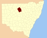
Cowper County, New South Wales
Encyclopedia
Cowper County, New South Wales is one of the 141 Cadastral divisions of New South Wales
.
Cowper County is named in honour of the politician and Premier of New South Wales, Sir Charles Cowper
(1807-1875).
It is located to the south-east of Bourke
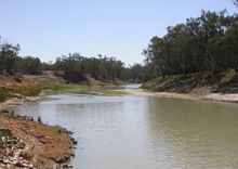
, with the Darling River
the boundary to the northwest, and the Bogan River
the boundary to the northeast.
Cadastral divisions of New South Wales
Lands administrative divisions of New South Wales refers to the 141 counties within the Australian state of New South Wales, which are further subdivided into 7,459 parishes. There are also three Land Divisions, around 100 Land Districts, and several other types of districts as well as land boards...
.
Cowper County is named in honour of the politician and Premier of New South Wales, Sir Charles Cowper
Charles Cowper
Sir Charles Cowper, KCMG was an Australian politician and the Premier of New South Wales on five different occasions from 1856 to 1870....
(1807-1875).
It is located to the south-east of Bourke
Bourke, New South Wales
-Transportation:Bourke can be reached by the Mitchell Highway, with additional sealed roads from town to the north , east and south . The town is also served by Bourke Airport and has Countrylink bus service to other regional centres, like Dubbo...
, with the Darling River
Darling River
The Darling River is the third longest river in Australia, measuring from its source in northern New South Wales to its confluence with the Murray River at Wentworth, New South Wales. Including its longest contiguous tributaries it is long, making it the longest river system in Australia.The...
the boundary to the northwest, and the Bogan River
Bogan River
The Bogan River is an inland river in the central west of New South Wales, Australia.This river rises at Goonumbla, 19 kilometres north-west of Parkes and flows in a generally north-north-westerly direction past Tottenham, Peak Hill and through Nyngan. The Bogan River is about 590 km in length...
the boundary to the northeast.
Parishes within this county
A full list of parishes found within this county; their current LGA and mapping coordinates to the approximate centre of each location is as follows:| Parish | LGA | Coordinates |
|---|---|---|
| Annandale Annandale, New South Wales Annandale is a suburb of Inner West Sydney in the state of New South Wales, Australia. Annandale is located within 3-5 kilometres west of the Sydney central business district and is part of the local government area of the Municipality of Leichhardt. Annandale's northern end lies on Rozelle Bay,... |
Cobar Shire | 30°41′20"S 146°03′00"E |
| Banga | Bourke Shire | 30°09′36"S 145°52′02"E |
| Barton | Bourke Shire | 30°09′37"S 145°58′52"E |
| Belars | Bogan Shire | 30°52′06"S 146°24′36"E |
| Billa Bulla | Bourke Shire | 30°35′38"S 145°47′43"E |
| Booda | Bourke Shire | 30°07′18"S 146°18′07"E |
| Bookambone | Brewarrina Shire | 30°22′19"S 146°49′01"E |
| Bourinawarrina | Bourke Shire | 29°59′02"S 146°17′58"E |
| Bourke Bourke, New South Wales -Transportation:Bourke can be reached by the Mitchell Highway, with additional sealed roads from town to the north , east and south . The town is also served by Bourke Airport and has Countrylink bus service to other regional centres, like Dubbo... |
Bourke Shire | 30°06′49"S 145°53′09"E |
| Buccambone | Bourke Shire | 30°30′15"S 145°41′25"E |
| Bunglega | Brewarrina Shire | 30°46′32"S 146°51′09"E |
| Burton | Cobar Shire | 30°54′40"S 146°20′23"E |
| Bye | Bourke Shire | 30°38′18"S 146°23′24"E |
| Cockerminia | Bourke Shire | 30°01′34"S 146°11′12"E |
| Coolibar | Bogan Shire | 30°48′44"S 146°56′12"E |
| Coorilla | Bourke Shire | 30°29′43"S 145°54′50"E |
| Currawynnia | Bourke Shire | 30°49′37"S 145°54′04"E |
| Dalby | Cobar Shire | 30°50′44"S 146°14′39"E |
| Davidson Davidson, New South Wales Davidson is a suburb of northern Sydney, in the state of New South Wales, Australia. Davidson is located 20 kilometres north-east of the Sydney central business district, in the local government area of Warringah Council... |
Bourke Shire | 30°04′31"S 146°05′17"E |
| Dederang | Cobar Shire | 30°59′36"S 146°12′28"E |
| Delatite | Bourke Shire | 30°06′31"S 146°11′12"E |
| Dijoe | Cobar Shire | 30°50′48"S 146°00′04"E |
| Donald | Bourke Shire | 30°43′26"S 145°55′23"E |
| Doradilla | Bourke Shire | 30°17′02"S 146°20′00"E |
| Drouin | Cobar Shire | 31°04′34"S 146°14′12"E |
| Dwyer | Bourke Shire | 30°27′04"S 146°08′45"E |
| East Bourke | Bourke Shire | 30°07′09"S 145°58′37"E |
| Edenhope | Bogan Shire | 30°46′05"S 146°26′01"E |
| Edgeroi Edgeroi, New South Wales Edgeroi is a small township in the northwest of New South Wales, Australia, located between Narrabri and Moree. The Newell Highway and the North-West railway line pass through the township. The now-disused railway station opened in 1897. The War Memorial plaque from the railway station has been... |
Bourke Shire | 30°49′13"S 146°19′41"E |
| Euroa | Bourke Shire | 30°14′51"S 146°08′49"E |
| Farnell | Bourke Shire | 30°27′22"S 145°50′18"E |
| Finlay | Bourke Shire | 30°40′20"S 146°12′17"E |
| Garfield | Bogan Shire | 30°50′05"S 147°00′43"E |
| Gongolgon | Brewarrina Shire | 30°23′48"S 146°55′23"E |
| Goulburn Goulburn, New South Wales Goulburn is a provincial city in the Southern Tablelands of New South Wales, Australia in Goulburn Mulwaree Council Local Government Area. It is located south-west of Sydney on the Hume Highway and above sea-level. On Census night 2006, Goulburn had a population of 20,127 people... |
Bogan Shire | 30°58′46"S 146°34′45"E |
| Gralga | Brewarrina Shire | 30°26′44"S 146°44′41"E |
| Gruyere | Brewarrina Shire | 30°10′30"S 146°28′51"E |
| Gundawarra | Brewarrina Shire | 30°23′07"S 146°40′03"E |
| Hazelwood | Brewarrina Shire | 30°42′04"S 146°33′45"E |
| Hillsborough Hillsborough, New South Wales Hillsborough is a suburb of Newcastle, New South Wales, Australia, located from Newcastle's central business district on the eastern side of Lake Macquarie. It is part of the City of Lake Macquarie local government area.- History :... |
Brewarrina Shire | 30°29′09"S 146°50′59"E |
| Howqua | Brewarrina Shire | 30°35′23"S 146°34′56"E |
| Huntly | Bogan Shire | 30°49′59"S 146°29′33"E |
| Irrewarra | Brewarrina Shire | 30°21′11"S 146°25′19"E |
| Jandra | Bourke Shire | 30°12′11"S 145°47′31"E |
| Jarara | Bogan Shire | 31°01′20"S 146°21′41"E |
| Kaiwilta | Cobar Shire | 30°55′30"S 146°02′07"E |
| Kaniva | Brewarrina Shire | 30°29′48"S 146°36′06"E |
| Kergunyah | Cobar Shire | 31°08′24"S 146°06′57"E |
| Kialla | Brewarrina Shire | 30°36′39"S 146°29′10"E |
| Kitchela | Bourke Shire | 30°26′47"S 146°00′07"E |
| Koorooman | Cobar Shire | 31°05′20"S 146°03′00"E |
| Koroit | Brewarrina Shire | 30°45′30"S 146°42′05"E |
| Lee | Cobar Shire | 30°47′31"S 145°57′52"E |
| Little | Cobar Shire | 30°53′25"S 145°56′00"E |
| Loftus Loftus, New South Wales Loftus is a suburb, in southern Sydney, in the state of New South Wales, Australia. Loftus is located 29 kilometres south of the Sydney central business district, in the local government area of the Sutherland Shire.... |
Brewarrina Shire | 30°13′05"S 146°27′57"E |
| Mackay | Bourke Shire | 30°11′59"S 146°04′02"E |
| Madson | Bogan Shire | 30°57′05"S 146°47′36"E |
| Maffra | Bourke Shire | 30°36′28"S 146°20′44"E |
| Manwanga | Bourke Shire | 30°17′15"S 145°44′25"E |
| Marong | Bourke Shire | 30°33′27"S 146°19′34"E |
| Maroona | Bourke Shire | 30°22′22"S 146°00′35"E |
| Medway Medway, New South Wales Medway is a small town in the Southern Highlands of New South Wales, Australia, in Wingecarribee Shire. It was formerly known as Village of Medway.... |
Bogan Shire | 30°43′48"S 146°23′58"E |
| Mialora | Bourke Shire | 30°21′10"S 146°09′06"E |
| Miendetta | Bourke Shire | 30°19′12"S 145°53′20"E |
| Mirboo | Bogan Shire | 30°58′01"S 146°25′54"E |
| Moira Moira, New South Wales Moira is a rural community in the central south part of the Riverina and the site of a railway station. It is situated by road, about 11 kilometres north from Barnes and 15 kilometres south west from Mathoura.... |
Bourke Shire | 30°11′42"S 146°16′12"E |
| Moodana | Bourke Shire | 30°22′13"S 145°41′36"E |
| Mootcha | Bourke Shire | 30°14′38"S 146°20′48"E |
| Morwell | Cobar Shire | 30°56′00"S 146°15′14"E |
| Mulgawarrina | Brewarrina Shire | 30°42′21"S 146°53′51"E |
| Mulholland | Bourke Shire | 30°22′35"S 146°20′33"E |
| Narragan | Cobar Shire | 31°00′22"S 146°04′34"E |
| Nemina | Brewarrina Shire | 30°40′30"S 146°43′39"E |
| Nidgery | Brewarrina Shire | 30°39′13"S 146°51′34"E |
| Numurkah | Bogan Shire | 30°51′10"S 146°38′41"E |
| Nurathulla | Bourke Shire | 30°16′25"S 145°55′20"E |
| Oakleigh | Brewarrina Shire | 30°05′32"S 146°25′10"E |
| Oakvale | Bourke Shire | 30°46′52"S 146°18′55"E |
| Oliver | Bourke Shire | 30°32′23"S 146°08′46"E |
| Oxley Oxley, New South Wales Oxley is a community on the lower Lachlan River in the Riverina district of New South Wales, Australia. It is located near the junction of the Lachlan and Murrumbidgee rivers. The township which developed in the mid 1860s was named after the noted Australian explorer, John Oxley... |
Bourke Shire | 30°08′36"S 146°10′13"E |
| Parailla | Bourke Shire | 30°22′37"S 145°48′17"E |
| Perayambone | Cobar Shire | 30°56′02"S 146°09′25"E |
| Pink Hills | Brewarrina Shire | 30°15′18"S 146°36′12"E |
| Puthawarrie | Bourke Shire | 30°36′32"S 145°59′57"E |
| Randall | Brewarrina Shire | 30°21′19"S 146°44′58"E |
| Redbank | Bourke Shire | 30°25′53"S 145°38′20"E |
| Richardson | Bogan Shire | unknown |
| Robertson Robertson, New South Wales Robertson is a small town in the Southern Highlands of New South Wales, Australia, in Wingecarribee Shire. The town is located on the edge of an elevated plateau about 35 km from the coast. At the 2006 census, Robertson had a population of 1,206 people.Robertson is known for its high annual... |
Bourke Shire | 30°44′04"S 146°16′25"E |
| Ross | Bourke Shire | 30°37′36"S 146°10′53"E |
| Runnymede | Bogan Shire | 30°56′52"S 146°42′18"E |
| Russell | Brewarrina Shire | 30°45′59"S 146°34′38"E |
| Satiara | Brewarrina Shire | 30°27′32"S 146°35′42"E |
| Sinclair | Brewarrina Shire | 30°34′41"S 146°29′08"E |
| Stanhope | Brewarrina Shire | 30°16′22"S 146°26′23"E |
| Stawell | Bourke Shire | 30°18′27"S 146°13′35"E |
| Stuart | Bogan Shire | 30°51′22"S 146°46′17"E |
| Tarcoon | Brewarrina Shire | 30°20′27"S 146°39′27"E |
| Tilpa Tilpa, New South Wales Tilpa is a town in the Far West region of New South Wales, Australia. The town is located on the Darling River, in the Central Darling Shire Local Government area, north west of the state capital, Sydney.... |
Bourke Shire | 30°34′00"S 145°56′02"E |
| Tobin | Brewarrina Shire | 30°27′06"S 146°27′05"E |
| Trafalgar | Cobar Shire | 30°47′46"S 146°04′19"E |
| Traralgon | Brewarrina Shire | 30°48′01"S 146°43′49"E |
| Trawalla | Bourke Shire | 30°24′45"S 146°15′36"E |
| Tubba | Bogan Shire | 30°47′24"S 147°00′07"E |
| Tuppulmummi | Bourke Shire | 30°25′48"S 145°43′58"E |
| Wadell | Bourke Shire | 30°27′45"S 146°18′11"E |
| Wagra | Cobar Shire | 31°02′30"S 146°08′50"E |
| Wanalta | Brewarrina Shire | 30°22′30"S 146°32′33"E |
| Wangoom | Bogan Shire | 30°54′55"S 146°33′00"E |
| Waterloo Waterloo, New South Wales Waterloo is an inner-city suburb of Sydney, New South Wales, Australia. Waterloo is located 4 kilometres south of the Sydney central business district and is part of the local government area of the City of Sydney.-History:... |
Cobar Shire | 30°46′23"S 146°06′23"E |
| Wererina | Bourke Shire | 30°40′30"S 145°49′38"E |
| West Bogan | Bogan Shire | 30°54′14"S 146°51′24"E |
| Whakoo | Bourke Shire | 30°32′56"S 146°00′29"E |
| Wilga | Cobar Shire | 30°51′35"S 146°09′23"E |
| Willa Murra | Brewarrina Shire | unknown |
| Yargunyah | Bourke Shire | 30°31′35"S 145°49′14"E |
| Yarraman | Bogan Shire | 30°54′17"S 146°57′03"E |
| Zouch | Bourke Shire | 30°19′38"S 146°01′03"E |