
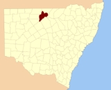
Gunderbooka County, New South Wales
Encyclopedia
Gunderbooka County is one of the 141 Cadastral divisions of New South Wales
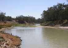
. The Warrego River
is the western boundary, and the Culgoa River
and Darling River
is the south-eastern boundary. It includes the area down to where the Warrego meets the Darling, to the north of Bourke
(including North Bourke).
 Gunderbooka is believed to be derived from a local Aboriginal
word and is also the name of Gundabook Station.
Cadastral divisions of New South Wales
Lands administrative divisions of New South Wales refers to the 141 counties within the Australian state of New South Wales, which are further subdivided into 7,459 parishes. There are also three Land Divisions, around 100 Land Districts, and several other types of districts as well as land boards...
. The Warrego River
Warrego River
The Warrego River is situated in south west Queensland and north west New South Wales, Australia. It is the northernmost tributary of the Darling River....
is the western boundary, and the Culgoa River
Culgoa River
The Culgoa River is a continuation of one branch of the Balonne River in southern Queensland and flows south-west to join the Darling River near Bourke, New South Wales. It is named for the Aboriginal word meaning "Running Through". Tributaries of the Culgoa include Nebine, Mungallala and Wallam...
and Darling River
Darling River
The Darling River is the third longest river in Australia, measuring from its source in northern New South Wales to its confluence with the Murray River at Wentworth, New South Wales. Including its longest contiguous tributaries it is long, making it the longest river system in Australia.The...
is the south-eastern boundary. It includes the area down to where the Warrego meets the Darling, to the north of Bourke
Bourke, New South Wales
-Transportation:Bourke can be reached by the Mitchell Highway, with additional sealed roads from town to the north , east and south . The town is also served by Bourke Airport and has Countrylink bus service to other regional centres, like Dubbo...
(including North Bourke).
Indigenous Australians
Indigenous Australians are the original inhabitants of the Australian continent and nearby islands. The Aboriginal Indigenous Australians migrated from the Indian continent around 75,000 to 100,000 years ago....
word and is also the name of Gundabook Station.
Parishes within this county
A full list of parishes found within this county; their current LGA and mapping coordinates to the approximate centre of each location is as follows:| Parish | LGA | Coordinates |
|---|---|---|
| Aripilis | Bourke Shire | 30°17′04"S 145°30′52"E |
| Bibildoolie | Bourke Shire | 29°38′50"S 145°46′40"E |
| Booka | Bourke Shire | 30°04′00"S 145°27′42"E |
| Bothadoola | Bourke Shire | 30°02′43"S 145°34′43"E |
| Boyong | Bourke Shire | 30°09′40"S 145°44′44"E |
| Brandis | Bourke Shire | 29°53′49"S 145°57′50"E |
| Bullamunta | Bourke Shire | 30°00′33"S 145°58′14"E |
| Coolamon | Bourke Shire | 29°45′12"S 145°41′28"E |
| Cooning | Bourke Shire | 29°33′28"S 146°09′30"E |
| Cooper | Bourke Shire | 29°49′55"S 145°44′16"E |
| Courallie | Bourke Shire | 29°36′50"S 145°54′42"E |
| Cumbooka | Bourke Shire | 29°42′53"S 146°17′55"E |
| Cuttabulla | Bourke Shire | 29°28′28"S 145°57′10"E |
| Darling | Bourke Shire | 29°42′22"S 146°04′40"E |
| Fords Bridge | Bourke Shire | 29°50′53"S 145°29′45"E |
| Franklin | Bourke Shire | 30°06′25"S 145°40′43"E |
| Galar | Bourke Shire | 29°43′23"S 145°44′43"E |
| Goldson | Bourke Shire | 29°49′12"S 146°02′52"E |
| Greig | Bourke Shire | 29°51′28"S 145°57′58"E |
| Ledknapper | Bourke Shire | 29°35′32"S 146°13′26"E |
| Leila | Bourke Shire | 29°29′33"S 145°48′26"E |
| Looden | Bourke Shire | 29°50′10"S 146°14′11"E |
| Mooramia | Bourke Shire | 29°49′41"S 145°52′20"E |
| Mumpber | Bourke Shire | 30°11′14"S 145°30′50"E |
| Mungunyah | Bourke Shire | 29°24′54"S 145°51′06"E |
| Nellys Springs | Bourke Shire | 29°35′35"S 146°03′20"E |
| Nidgerie | Bourke Shire | 29°58′56"S 145°40′42"E |
| North Bourke | Bourke Shire | 30°02′45"S 145°56′33"E |
| Nulty | Bourke Shire | 30°12′35"S 145°38′01"E |
| Paka | Bourke Shire | 30°02′49"S 145°43′30"E |
| Palmer | Bourke Shire | 29°45′17"S 146°09′54"E |
| Pera | Bourke Shire | 30°03′54"S 145°52′24"E |
| Polo | Bourke Shire | 29°58′45"S 145°47′09"E |
| Quondong | Bourke Shire | 29°46′02"S 146°25′59"E |
| Sutherland | Bourke Shire | 29°53′48"S 145°37′33"E |
| Talaa | Bourke Shire | 30°00′33"S 145°52′02"E |
| Tobin | Bourke Shire | unknown |
| Toorale | Bourke Shire | 30°16′40"S 145°25′30"E |
| Tresillian | Bourke Shire | 29°46′22"S 145°53′50"E |
| Tully | Bourke Shire | 29°52′04"S 146°08′32"E |
| Turee | Bourke Shire | 29°54′43"S 146°06′02"E |
| Warraweena | Bourke Shire | 29°55′33"S 146°15′56"E |
| Wommera | Bourke Shire | 29°57′01"S 145°35′47"E |
| Yarraman | Bourke Shire | 29°40′53"S 146°21′15"E |
| Yurongan | Bourke Shire | 29°37′19"S 146°13′29"E |