
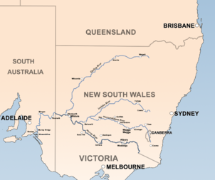
Lachlan River
Encyclopedia
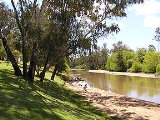
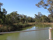
Course
The river rises in the central highland of New South Wales, part of the Great Dividing RangeGreat Dividing Range
The Great Dividing Range, or the Eastern Highlands, is Australia's most substantial mountain range and the third longest in the world. The range stretches more than 3,500 km from Dauan Island off the northeastern tip of Queensland, running the entire length of the eastern coastline through...
, 13 km east of Gunning
Gunning, New South Wales
Gunning is a town on the Old Hume Highway, between Goulburn and Yass in the Southern Tablelands of New South Wales, Australia, about 260 km south-west of Sydney and 75 km north of the national capital, Canberra. On Census night 2006, Gunning had a population of 487 people...
. Its major headwaters, the Carcoar River, the Belubula River
Belubula River
The Belubula River is a river of the state of New South Wales in Australia. It flows from Vittoria State Forest South of Vittoria to its confluence with the Lachlan River, East of Gooloogong....
and the Abercrombie River
Abercrombie River
The Abercrombie River is a river in New South Wales, Australia, flowing from Mount Werong westward to the Wyangala Dam near Cowra. The river is a tributary of the Lachlan, which it joins at Wyangala lake....
converge near the town of Cowra
Cowra, New South Wales
Cowra is a town in the Central West region of New South Wales, Australia in the Cowra Shire. It is located on the Mid-Western Highway, 317 kilometres west of Sydney on the banks of the Lachlan River at an altitude of 310 metres above sea level. At the 2006 census Cowra had a population of 8,430...
. Minor tributaries include the Morongla Creek
Morongla Creek, New South Wales
Morongla Creek is a small town, or hamlet, in New South Wales, Australia, in Cowra Shire. It is 13 km South of Cowra by road. Other near-by districts and/or villages are: Neila Creek, Cocomingla, Cucumgilliga, Wattamondara, and Noonbinna. Just south of the village rises the well-known...
. Other tributaries include the Boorowa River
Boorowa River
-References:...
and Crookwell River
Crookwell River
-References:...
s.
Wyangala Dam
Wyangala Dam
Wyangala Dam is a large water storage facility located in the southwest slopes area of New South Wales, Australia. The dam is situated below the junction of the Lachlan River and Abercrombie River. It was the second water storage project to be constructed by the Water Conservation and Irrigation...
was built near Cowra to regulate the flow of the river. However, the Lachlan, unlike the Murrumbidgee River
Murrumbidgee River
The Murrumbidgee River is a major river in the state of New South Wales, Australia, and the Australian Capital Territory . A major tributary of the Murray River, the Murrumbidgee flows in a west-northwesterly direction from the foot of Peppercorn Hill in the Fiery Range of the Snowy Mountains,...
and the Murray River
Murray River
The Murray River is Australia's longest river. At in length, the Murray rises in the Australian Alps, draining the western side of Australia's highest mountains and, for most of its length, meanders across Australia's inland plains, forming the border between New South Wales and Victoria as it...
further south, does not have its source in the snowfields and does not enjoy the large and reliable spring flow from the melting snow from which those rivers benefit. Indeed, the annual flow of the Lachlan is too erratic for really reliable dams to be possible. Annual flows have ranged from less than 1,000 megalitres (810 acre.ft) in 1944 to as much as 10,900 megalitres (8800 acre.ft) in 1950. In dry years, the Lachlan can have periods of zero flow of over a year (for example from April 1944 to April 1945), which is a complete contrast to the Murray and Murrumbidgee which have not been known to cease to flow since European settlement. The river has flooded every seven years since 1887 at Forbes
Forbes, New South Wales
-Notable residents:*Carolyn Simpson - Judge of the Supreme Court of New South Wales; Member of the first all-female bench to sit in an Australian court*NSW Deputy Premier Carmel Tebbutt was born and raised in Forbes....
.
Oxley, New South Wales
Oxley is a community on the lower Lachlan River in the Riverina district of New South Wales, Australia. It is located near the junction of the Lachlan and Murrumbidgee rivers. The township which developed in the mid 1860s was named after the noted Australian explorer, John Oxley...
(between Hay
Hay, New South Wales
Hay is a town in the western Riverina region of south western New South Wales , Australia. It is the administrative centre of Hay Shire Local Government Area and the centre of a prosperous and productive agricultural district on the wide Hay Plains....
and Balranald
Balranald, New South Wales
Balranald is a town and local government area in the Riverina district of New South Wales, Australia. At the 2006 census the population was 1,216....
). The 500 km² swamp, a floodplain
Floodplain
A floodplain, or flood plain, is a flat or nearly flat land adjacent a stream or river that stretches from the banks of its channel to the base of the enclosing valley walls and experiences flooding during periods of high discharge...
for the Lachlan, joins the Murrumbidgee River
Murrumbidgee River
The Murrumbidgee River is a major river in the state of New South Wales, Australia, and the Australian Capital Territory . A major tributary of the Murray River, the Murrumbidgee flows in a west-northwesterly direction from the foot of Peppercorn Hill in the Fiery Range of the Snowy Mountains,...
to the south and becomes part of the Lowbidgee Floodplain
Lowbidgee Floodplain
The Lowbidgee Floodplain extends from Balranald to near Waradgery Station, about 20 km west of Hay, in south-western New South Wales. It comprises an extensive floodplain of the lower Murrumbidgee River and its tributaries, including the confluence of the Murrumbidgee with the Lachlan River,...
. There is some irrigation in the middle reaches of the Lachlan.
History
Wiradjuri
The Wiradjuri are an Indigenous Australian group of central New South Wales.In the 21st century, major Wiradjuri groups live in Condobolin, Peak Hill, Narrandera and Griffith...
people. The Wiradjuri tribal area has been described as "the land of the three rivers, the Wambool later known as the Macquarie, the Kalare later known as the Lachlan and the Murrumbidgee
Murrumbidgee River
The Murrumbidgee River is a major river in the state of New South Wales, Australia, and the Australian Capital Territory . A major tributary of the Murray River, the Murrumbidgee flows in a west-northwesterly direction from the foot of Peppercorn Hill in the Fiery Range of the Snowy Mountains,...
(Murrumbidjeri). The Murray River
Murray River
The Murray River is Australia's longest river. At in length, the Murray rises in the Australian Alps, draining the western side of Australia's highest mountains and, for most of its length, meanders across Australia's inland plains, forming the border between New South Wales and Victoria as it...
formed the Wiradjuri's southern boundary, the change from woodland to open grassland formed their eastern boundary."
The European discoverer of the Lachlan River in 1815 was Acting-Surveyor George William Evans, who named the river after Lachlan Macquarie
Lachlan Macquarie
Major-General Lachlan Macquarie CB , was a British military officer and colonial administrator. He served as the last autocratic Governor of New South Wales, Australia from 1810 to 1821 and had a leading role in the social, economic and architectural development of the colony...
, the Governor
Governor
A governor is a governing official, usually the executive of a non-sovereign level of government, ranking under the head of state...
of the colony of New South Wales
New South Wales
New South Wales is a state of :Australia, located in the east of the country. It is bordered by Queensland, Victoria and South Australia to the north, south and west respectively. To the east, the state is bordered by the Tasman Sea, which forms part of the Pacific Ocean. New South Wales...
. The Lachlan River was substantially explored by John Oxley
John Oxley
John Joseph William Molesworth Oxley was an explorer and surveyor of Australia in the early period of English colonisation.October 1802 he was engaged in coastal survey work including an expedition to Western Port in 1804-05...
in 1817.
In the early days of the colony of New South Wales, the southern part of the Lachlan was known as Fish River. It was only after further exploration that it was realised that these two rivers were the same river and the name Fish River was dropped.
In 1870 the river peaked at 15.9 metres at Cowra. Since 1887, the highest flood level at Forbes was in June 1952 when the river peaked at 10.80m (35 feet 3 inches) at the Forbes Iron Bridge. More than 900 families were evacuated, with many rescued from roof-tops by boat and helicopter. During the flood in August 1990, 132 houses in Forbes were affected by flood with their yards or their floors covered by water. Floods in 1992 did not reach the same levels at Forbes as in 1990, however, Lachlan Valley farmers lost about 30 percent of their lucerne crops just before harvest. At least 500 sheep were drowned on properties in the Eugowra/Trundle area and most of Eugowra's 400 residents were evacuated and some residents from Trundle. Other significant years of floods were: 1891, 1916, 1951, 1956, 1961, 1974, 1976, 1993, 1998.
Economy
More than 100,000 people live in the Lachlan catchment. 14% of NSW agricultural production is generated in the region from a land area of approximately 10% of NSW. 24 local government organisationsLocal Government Areas of New South Wales
The local government areas of New South Wales, Australia have been subject to periodic bouts of restructuring and rationalisation by the State Government, involving voluntary and involuntary amalgamation of areas...
provide administration within the region.
The river passes through the towns of Breadalbane
Breadalbane, New South Wales
Breadalbane is a small village located in the Southern Tablelands of New South Wales, Australia in Upper Lachlan Shire. It is located on the Lachlan River headwaters and not far from Goulburn. This little town is also located nearby and adjacent to the major Hume Highway which links Sydney to...
, Bevandale, Reids Flat
Reids Flat, New South Wales
Reids Flat is a small historic village sited on the south bank of the Lachlan River, approximately 40 kilometres southeast of Wyangala Dam, in the northeastern corner of Boorowa Shire, in the South West Slopes region of New South Wales, hidden in the Great Dividing Range.The village – now...
, Cowra
Cowra, New South Wales
Cowra is a town in the Central West region of New South Wales, Australia in the Cowra Shire. It is located on the Mid-Western Highway, 317 kilometres west of Sydney on the banks of the Lachlan River at an altitude of 310 metres above sea level. At the 2006 census Cowra had a population of 8,430...
, Gooloogong
Gooloogong, New South Wales
Gooloogong is a village located in central New South Wales, Australia. At the 2006 census, Gooloogong and the surrounding area had a population of 852....
, Paytens Bridge, Tomanbil, Forbes
Forbes, New South Wales
-Notable residents:*Carolyn Simpson - Judge of the Supreme Court of New South Wales; Member of the first all-female bench to sit in an Australian court*NSW Deputy Premier Carmel Tebbutt was born and raised in Forbes....
, Jemalong, Bedgerebong, Waroo, Fairholme, Condobolin
Condobolin, New South Wales
Condobolin is a town in the west of the Central West region of New South Wales, Australia, on the Lachlan River. At the 2006 census, Condobolin had a population of 2,847.- History :...
, Gunebang, Euabalong, Hillston
Hillston, New South Wales
Hillston is a township in western New South Wales, Australia, in Carrathool Shire, built on the banks of the Lachlan River. It was founded in 1863 and at the 2006 census had a population of 1,054.-History:...
, Booligal
Booligal, New South Wales
Booligal is a village in the Riverina area of western New South Wales , Australia. It is located on the Cobb Highway, on the Lachlan River north of Hay...
, Oxley
Oxley, New South Wales
Oxley is a community on the lower Lachlan River in the Riverina district of New South Wales, Australia. It is located near the junction of the Lachlan and Murrumbidgee rivers. The township which developed in the mid 1860s was named after the noted Australian explorer, John Oxley...
, Lake Cargelligo
Lake Cargelligo, New South Wales
Lake Cargelligo is a town in the Central West region of New South Wales, Australia, on Lake Cargelligo. It is in Lachlan Shire. At the 2006 census, Lake Cargelligo had a population of 1,146 people. Its name is said to be a corruption of the Aboriginal word 'Kartjellakoo' meaning 'he had a...
See also
- Darbys FallsDarbys fallsDarbys Falls is a town situated 15 km east of Cowra, New South Wales. It has a population of approximately 70 people, and is a major tourist destination of the region. It has a main street and a small school....
- List of rivers of Australia
- Wyangala DamWyangala DamWyangala Dam is a large water storage facility located in the southwest slopes area of New South Wales, Australia. The dam is situated below the junction of the Lachlan River and Abercrombie River. It was the second water storage project to be constructed by the Water Conservation and Irrigation...