

Pennsylvania Route 120
Encyclopedia
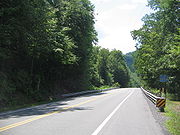
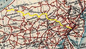
Pennsylvania Route 120 is a state highway in the U.S. state
of Pennsylvania
, running from U.S. Route 219 in Ridgway
east to U.S. Route 220 in Lock Haven
.
 In much of Cameron
and Clinton
counties, PA 120 is a scenic drive designated Bucktail State Park Natural Area
. Bucktail State Park Natural Area runs 75 miles (121 km) from Emporium
to Lock Haven, and is named for the Pennsylvania Bucktail Regiment
, who came from the area during the American Civil War
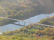
. PA 120 and the park run along Sinnemahoning Creek
and the West Branch Susquehanna River
and also pass through Renovo
(in Clinton County).
Bucktail State Park Natural Area was established by the Pennsylvania State Legislature in 1933. It includes 21039 acres (85.14 km²), of which 9239 acres (37.39 km²) are in Cameron County and 11800 acres (47.75 km²) in Clinton County. While much of the land is state owned and part of the Elk
and Sproul State Forest
s, there are also many tracts of privately owned land within the official boundaries of the park. The law establishing the park defined its boundaries as "all that area of land extending in length from the western city line of Lock Haven, in Clinton County, to the eastern borough line of Emporium, in The County of Cameron, and along the course of the western branch of the Susquehanna River, and its tributary, Sinnemahoning Creek, in Clinton and Cameron counties, an estimated distance of 75 miles, and in width from mountain rim to mountain rim across the valley." The park is primarily dedicated to wildlife viewing, especially elk
.
 Pennsylvania Route 120 follows an old Native American
Trail
, the Sinnemahoning Path
. This trail was used by Native Americans to cross the eastern continental divide
(specifically the Allegheny Front
) between the Susquehanna River
(which drains into the Chesapeake Bay
) and the Allegheny River
(which forms the Ohio River
with the Monongahela River
at Pittsburgh
and eventually drains into the Gulf of Mexico
via the Mississippi River
). American Pioneers also used the trail to make their way west and it was also known as the Bucktail Trail
PA 120 was U.S. Route 120 until ca. 1967. US 120 was initially planned in 1926 as an Erie
-Philadelphia
route, but was truncated to Ridgway
-Reading
in 1927. The road east of Lock Haven
became U.S. Route 220, U.S. Route 15 and U.S. Route 122 ca. 1935; this alignment is now roughly followed by US 220, Interstate 180
, PA Route 147
and PA Route 61
.
U.S. state
A U.S. state is any one of the 50 federated states of the United States of America that share sovereignty with the federal government. Because of this shared sovereignty, an American is a citizen both of the federal entity and of his or her state of domicile. Four states use the official title of...
of Pennsylvania
Pennsylvania
The Commonwealth of Pennsylvania is a U.S. state that is located in the Northeastern and Mid-Atlantic regions of the United States. The state borders Delaware and Maryland to the south, West Virginia to the southwest, Ohio to the west, New York and Ontario, Canada, to the north, and New Jersey to...
, running from U.S. Route 219 in Ridgway
Ridgway, Pennsylvania
Ridgway is a borough in and the county seat of Elk County, Pennsylvania, United States.-History:Ridgway was founded by Philadelphian shipping merchant Jacob Ridgway and James Gillis. Jacob Ridgway earned substantial wealth both in Philadelphia and abroad in London. He constantly sent sums of money...
east to U.S. Route 220 in Lock Haven
Lock Haven, Pennsylvania
The city of Lock Haven is the county seat of Clinton County, in the U.S. state of Pennsylvania. Located near the confluence of the West Branch Susquehanna River and Bald Eagle Creek, it is the principal city of the Lock Haven, Pennsylvania, micropolitan statistical area, itself part of the...
.
Bucktail State Park Natural Area
Cameron County, Pennsylvania
As of the census of 2000, there were 5,974 people, 2,465 households, and 1,624 families residing in the county. The population density was 15 people per square mile . There were 4,592 housing units at an average density of 12 per square mile...
and Clinton
Clinton County, Pennsylvania
As of the census of 2000, there were 37,914 people, 14,773 households, and 9,927 families residing in the county. The population density was 43 people per square mile . There were 18,166 housing units at an average density of 20 per square mile...
counties, PA 120 is a scenic drive designated Bucktail State Park Natural Area
Bucktail State Park Natural Area
Bucktail State Park Natural Area is a Pennsylvania state park in Cameron and Clinton Counties in Pennsylvania in the United States. The park follows Pennsylvania Route 120 for between Emporium and Lock Haven...
. Bucktail State Park Natural Area runs 75 miles (121 km) from Emporium
Emporium, Pennsylvania
Emporium is a borough in Cameron County, Pennsylvania, west-northwest of Williamsport. Early in the twentieth century, it had large powder plants and manufactories of radio tubes, incandescent lamps, paving brick, flour, iron, lumber, sole leather, etc. In 1900, 2,463 people lived in Emporium, and...
to Lock Haven, and is named for the Pennsylvania Bucktail Regiment
Bucktails
The Bucktails may refer to one of two organizations that were particularly characterized and identified by the wearing of a bucktail in their headgear....
, who came from the area during the American Civil War
American Civil War
The American Civil War was a civil war fought in the United States of America. In response to the election of Abraham Lincoln as President of the United States, 11 southern slave states declared their secession from the United States and formed the Confederate States of America ; the other 25...
. PA 120 and the park run along Sinnemahoning Creek
Sinnemahoning Creek
Sinnemahoning Creek is a tributary of the West Branch Susquehanna River in Cameron and Clinton counties, Pennsylvania, in the United States.Sinnemahoning Creek is formed by the confluence of the Bennett and Driftwood Branches at the borough of Driftwood.The tributary First Fork Sinnemahoning...
and the West Branch Susquehanna River
West Branch Susquehanna River
The West Branch Susquehanna River is one of the two principal branches, along with the North Branch, of the Susquehanna River in the northeastern United States. The North Branch, which rises in upstate New York, is generally regarded as the extension of the main branch, with the shorter West Branch...
and also pass through Renovo
Renovo, Pennsylvania
Renovo is a borough in Clinton County, Pennsylvania, northwest of Lock Haven. Deposits of bituminous coal and fire clay are in the region. In 1900, 4,082 people lived there, and in 1910, 4,621 lived there...
(in Clinton County).
Bucktail State Park Natural Area was established by the Pennsylvania State Legislature in 1933. It includes 21039 acres (85.14 km²), of which 9239 acres (37.39 km²) are in Cameron County and 11800 acres (47.75 km²) in Clinton County. While much of the land is state owned and part of the Elk
Elk State Forest
Elk State Forest is a Pennsylvania State Forest in Pennsylvania Bureau of Forestry District #13. The main offices are located in Emporium in Cameron County , Pennsylvania in the United States....
and Sproul State Forest
Sproul State Forest
Sproul State Forest is a Pennsylvania state forest in Pennsylvania Bureau of Forestry District #10. The main offices are located in Renovo, Pennsylvania in Clinton County in the United States....
s, there are also many tracts of privately owned land within the official boundaries of the park. The law establishing the park defined its boundaries as "all that area of land extending in length from the western city line of Lock Haven, in Clinton County, to the eastern borough line of Emporium, in The County of Cameron, and along the course of the western branch of the Susquehanna River, and its tributary, Sinnemahoning Creek, in Clinton and Cameron counties, an estimated distance of 75 miles, and in width from mountain rim to mountain rim across the valley." The park is primarily dedicated to wildlife viewing, especially elk
Elk
The Elk is the large deer, also called Cervus canadensis or wapiti, of North America and eastern Asia.Elk may also refer to:Other antlered mammals:...
.
History
Native Americans in the United States
Native Americans in the United States are the indigenous peoples in North America within the boundaries of the present-day continental United States, parts of Alaska, and the island state of Hawaii. They are composed of numerous, distinct tribes, states, and ethnic groups, many of which survive as...
Trail
Trail
A trail is a path with a rough beaten or dirt/stone surface used for travel. Trails may be for use only by walkers and in some places are the main access route to remote settlements...
, the Sinnemahoning Path
Sinnemahoning Path
The Sinnemahoning Path is an ancient trail which passes through what will be called Keating on its way to the upper Alleghenies. The Sinnemahoning Path followed the West Branch of the Susquehanna from “the Great Island” at Lock Haven to the Sinnemahoning Creek at Keating, to Portage Creek, then to...
. This trail was used by Native Americans to cross the eastern continental divide
Continental divide
A continental divide is a drainage divide on a continent such that the drainage basin on one side of the divide feeds into one ocean or sea, and the basin on the other side either feeds into a different ocean or sea, or else is endorheic, not connected to the open sea...
(specifically the Allegheny Front
Allegheny Front
The Allegheny Front is the major southeast- or east-facing escarpment in the Allegheny Mountains in southern Pennsylvania, western Maryland, and eastern West Virginia, USA. The Allegheny Front delineates the Ridge-and-Valley Appalachians to its east from the Appalachian Plateau to its west...
) between the Susquehanna River
Susquehanna River
The Susquehanna River is a river located in the northeastern United States. At long, it is the longest river on the American east coast that drains into the Atlantic Ocean, and with its watershed it is the 16th largest river in the United States, and the longest river in the continental United...
(which drains into the Chesapeake Bay
Chesapeake Bay
The Chesapeake Bay is the largest estuary in the United States. It lies off the Atlantic Ocean, surrounded by Maryland and Virginia. The Chesapeake Bay's drainage basin covers in the District of Columbia and parts of six states: New York, Pennsylvania, Delaware, Maryland, Virginia, and West...
) and the Allegheny River
Allegheny River
The Allegheny River is a principal tributary of the Ohio River; it is located in the Eastern United States. The Allegheny River joins with the Monongahela River to form the Ohio River at the "Point" of Point State Park in Downtown Pittsburgh, Pennsylvania...
(which forms the Ohio River
Ohio River
The Ohio River is the largest tributary, by volume, of the Mississippi River. At the confluence, the Ohio is even bigger than the Mississippi and, thus, is hydrologically the main stream of the whole river system, including the Allegheny River further upstream...
with the Monongahela River
Monongahela River
The Monongahela River is a river on the Allegheny Plateau in north-central West Virginia and southwestern Pennsylvania in the United States...
at Pittsburgh
Pittsburgh, Pennsylvania
Pittsburgh is the second-largest city in the US Commonwealth of Pennsylvania and the county seat of Allegheny County. Regionally, it anchors the largest urban area of Appalachia and the Ohio River Valley, and nationally, it is the 22nd-largest urban area in the United States...
and eventually drains into the Gulf of Mexico
Gulf of Mexico
The Gulf of Mexico is a partially landlocked ocean basin largely surrounded by the North American continent and the island of Cuba. It is bounded on the northeast, north and northwest by the Gulf Coast of the United States, on the southwest and south by Mexico, and on the southeast by Cuba. In...
via the Mississippi River
Mississippi River
The Mississippi River is the largest river system in North America. Flowing entirely in the United States, this river rises in western Minnesota and meanders slowly southwards for to the Mississippi River Delta at the Gulf of Mexico. With its many tributaries, the Mississippi's watershed drains...
). American Pioneers also used the trail to make their way west and it was also known as the Bucktail Trail
PA 120 was U.S. Route 120 until ca. 1967. US 120 was initially planned in 1926 as an Erie
Erie, Pennsylvania
Erie is a city located in northwestern Pennsylvania in the United States. Named for the lake and the Native American tribe that resided along its southern shore, Erie is the state's fourth-largest city , with a population of 102,000...
-Philadelphia
Philadelphia, Pennsylvania
Philadelphia is the largest city in the Commonwealth of Pennsylvania and the county seat of Philadelphia County, with which it is coterminous. The city is located in the Northeastern United States along the Delaware and Schuylkill rivers. It is the fifth-most-populous city in the United States,...
route, but was truncated to Ridgway
Ridgway, Pennsylvania
Ridgway is a borough in and the county seat of Elk County, Pennsylvania, United States.-History:Ridgway was founded by Philadelphian shipping merchant Jacob Ridgway and James Gillis. Jacob Ridgway earned substantial wealth both in Philadelphia and abroad in London. He constantly sent sums of money...
-Reading
Reading, Pennsylvania
Reading is a city in southeastern Pennsylvania, USA, and seat of Berks County. Reading is the principal city of the Greater Reading Area and had a population of 88,082 as of the 2010 census, making it the fifth most populated city in the state after Philadelphia, Pittsburgh, Allentown and Erie,...
in 1927. The road east of Lock Haven
Lock Haven, Pennsylvania
The city of Lock Haven is the county seat of Clinton County, in the U.S. state of Pennsylvania. Located near the confluence of the West Branch Susquehanna River and Bald Eagle Creek, it is the principal city of the Lock Haven, Pennsylvania, micropolitan statistical area, itself part of the...
became U.S. Route 220, U.S. Route 15 and U.S. Route 122 ca. 1935; this alignment is now roughly followed by US 220, Interstate 180
Interstate 180 (Pennsylvania)
Interstate 180 is a spur highway that connects Williamsport, Pennsylvania to Interstate 80 near Milton, Pennsylvania. The length of the highway is . It was also the designation of present-day Interstate 176 between Morgantown, Pennsylvania and Reading, when the Pennsylvania Turnpike carried the...
, PA Route 147
Pennsylvania Route 147
Pennsylvania Route 147 is a north–south route that runs for along the east shore of the Susquehanna River in central Pennsylvania, United States. The northern terminus is at an interchange with Interstate 80 and Interstate 180 in Turbot Township. The southern terminus is at an interchange...
and PA Route 61
Pennsylvania Route 61
Pennsylvania Route 61 is an -long state highway in the U.S. state of Pennsylvania. The route is signed on a north–south direction, from U.S. Route 222 Business in Reading to U.S. Route 11 and U.S. Route 15 in Shamokin Dam. PA 61 meets up with Pennsylvania Route 54 in Ashland and these...
.