
South Renovo, Pennsylvania
Encyclopedia
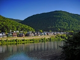
South Renovo is a borough in Clinton County
, Pennsylvania
, United States
. The population was 557 at the 2000 census.
According to the United States Census Bureau
, the borough has a total area of 0.2 square miles (0.6 km²), of which, 0.2 square miles (0.5 km²) of it is land and 0.04 square miles (0.1 km²) of it (16.67%) is water.
of 2000, there were 557 people, 226 households, and 141 families residing in the borough. The population density
was 2,824.2 people per square mile (1,075.3/km²). There were 261 housing units at an average density of 1,323.4 per square mile (503.9/km²). The racial makeup of the borough was 99.82% White and 0.18% Native American.
There were 226 households out of which 29.2% had children under the age of 18 living with them, 46.9% were married couples
living together, 10.6% had a female householder with no husband present, and 37.6% were non-families. 35.8% of all households were made up of individuals and 24.3% had someone living alone who was 65 years of age or older. The average household size was 2.28 and the average family size was 2.92.
In the borough the population was spread out with 22.3% under the age of 18, 5.6% from 18 to 24, 22.1% from 25 to 44, 22.4% from 45 to 64, and 27.6% who were 65 years of age or older. The median age was 45 years. For every 100 females there were 88.2 males. For every 100 females age 18 and over, there were 83.5 males.
The median income for a household in the borough was $24,853, and the median income for a family was $34,625. Males had a median income of $30,455 versus $17,639 for females. The per capita income
for the borough was $14,751. About 6.8% of families and 10.4% of the population were below the poverty line, including 16.0% of those under age 18 and 8.9% of those age 65 or over.
Clinton County, Pennsylvania
As of the census of 2000, there were 37,914 people, 14,773 households, and 9,927 families residing in the county. The population density was 43 people per square mile . There were 18,166 housing units at an average density of 20 per square mile...
, Pennsylvania
Pennsylvania
The Commonwealth of Pennsylvania is a U.S. state that is located in the Northeastern and Mid-Atlantic regions of the United States. The state borders Delaware and Maryland to the south, West Virginia to the southwest, Ohio to the west, New York and Ontario, Canada, to the north, and New Jersey to...
, United States
United States
The United States of America is a federal constitutional republic comprising fifty states and a federal district...
. The population was 557 at the 2000 census.
Geography
South Renovo is located at 41°19′28"N 77°44′40"W (41.324405, -77.744307).According to the United States Census Bureau
United States Census Bureau
The United States Census Bureau is the government agency that is responsible for the United States Census. It also gathers other national demographic and economic data...
, the borough has a total area of 0.2 square miles (0.6 km²), of which, 0.2 square miles (0.5 km²) of it is land and 0.04 square miles (0.1 km²) of it (16.67%) is water.
Demographics
As of the censusCensus
A census is the procedure of systematically acquiring and recording information about the members of a given population. It is a regularly occurring and official count of a particular population. The term is used mostly in connection with national population and housing censuses; other common...
of 2000, there were 557 people, 226 households, and 141 families residing in the borough. The population density
Population density
Population density is a measurement of population per unit area or unit volume. It is frequently applied to living organisms, and particularly to humans...
was 2,824.2 people per square mile (1,075.3/km²). There were 261 housing units at an average density of 1,323.4 per square mile (503.9/km²). The racial makeup of the borough was 99.82% White and 0.18% Native American.
There were 226 households out of which 29.2% had children under the age of 18 living with them, 46.9% were married couples
Marriage
Marriage is a social union or legal contract between people that creates kinship. It is an institution in which interpersonal relationships, usually intimate and sexual, are acknowledged in a variety of ways, depending on the culture or subculture in which it is found...
living together, 10.6% had a female householder with no husband present, and 37.6% were non-families. 35.8% of all households were made up of individuals and 24.3% had someone living alone who was 65 years of age or older. The average household size was 2.28 and the average family size was 2.92.
In the borough the population was spread out with 22.3% under the age of 18, 5.6% from 18 to 24, 22.1% from 25 to 44, 22.4% from 45 to 64, and 27.6% who were 65 years of age or older. The median age was 45 years. For every 100 females there were 88.2 males. For every 100 females age 18 and over, there were 83.5 males.
The median income for a household in the borough was $24,853, and the median income for a family was $34,625. Males had a median income of $30,455 versus $17,639 for females. The per capita income
Per capita income
Per capita income or income per person is a measure of mean income within an economic aggregate, such as a country or city. It is calculated by taking a measure of all sources of income in the aggregate and dividing it by the total population...
for the borough was $14,751. About 6.8% of families and 10.4% of the population were below the poverty line, including 16.0% of those under age 18 and 8.9% of those age 65 or over.