

British Columbia provincial highway 1
Encyclopedia
Highway 1 is part of the British Columbia
section of the Trans-Canada Highway
. Its total accumulated distance through British Columbia is 1,039 km (646 mi), including the distance travelled on ferries.
 The Vancouver Island
branch of Highway 1, known locally as the Island Highway
(a name shared with Highway 19), is the main thoroughfare on the south Island. The highway was first given the "1" designation in 1941, and originally went between Victoria
and Kelsey Bay
, a small coastal community north of Campbell River
. Highway 1 on the Island was shortened to terminate in the downtown core of the city of Nanaimo
in 1953, with the section north of Nanaimo being re-numbered 19. When BC Ferries
took over the ferry route between Departure Bay in Nanaimo and Horseshoe Bay in West Vancouver in 1961, Highway 1 on the Island was extended to the Departure Bay ferry dock.
and Dallas Road in Victoria, where a large "mile zero" sign is erected. Highway 1 proceeds north through the city of Victoria for 4 km (2½ mi), passing by the southern terminus of Highway 17, before leaving the city at Tolmie Avenue. Once out of Victoria there are three at grade intersections at Boleskine Rd, Tillicum Rd and Mckenzie Avenue. Between Tillicum and Mckenzie there is a limited interchange at Interurban (south bound off-ramp). Highway 1 then continues on a 10 km (6 mi) long four to six lane freeway, with four interchanges along its length, one of which leads to the start of Highway 14 until Spencer Rd in Langford. Currently, an interchange is being constructed which will extend the freeway to the last light out of Langford at Westshore Parkway. The highway narrows to two lanes upon its entry into Goldstream Provincial Park
. The highway from this point is known locally as the Malahat
.
From the southern entrance to Goldstream park, the Malahat section of the highway, which is known for its steep grades, goes north for 20 km (12 mi), becoming three lanes on its exit from Goldstream park and passing through the community of Malahat proper en route, until it reaches the community of Mill Bay
. Here it once again widens out into four lanes (with an interchange at Mill Bay Road), just south of signalized intersections at Frayne Road and Deloume Road. The Trans Canada Highway then travels north through a gauntlet of fifteen traffic lights for 29 km (18 mi). These provide access to Shawnigan Lake
(stoplights at Shawnigan Lake Road), Cobble Hill
(Cobble Hill Road, Hutchinson Road and Fisher Road), Cowichan Bay
(Cowichan Bay Road, Koksilah Road, and Bench Road) and Duncan
(closely spaced signals at Allenby Road, Boys Road, Trunk Road, Coronation Avenue, James Street, Beverly Street, Green Road, and Drinkwater Road). Next is a signalized junction with Highway 18. The highway then proceeds north for 10 km (6 mi) through stoplights at Mays Road and Mount Sicker Road to a signalized intersection at Henry Road serving Chemainus
.
From the Chemainus junction, Highway 1 travels 11 km (7 mi) northwest to the city of Ladysmith
accessed by intersections with traffic lights at Davis Road, Roberts Street, and Ludlow Road. It then continues northwest for another 13 km (8 mi)through signalized junctions at Oyster Road, Cedar Road, Timberlands Road, and Spitfire Way, the last of which provides access to Nanaimo Airport. The highway then reaches an unsignalized junction at Cassidy
. Immeditately north of the Nanamio River Bridge there is an interchange to Nanaimo River Road. 6 km (4 mi) north of Cassidy, Highway 1 enters the city of Nanaimo, where Highway 19 merges onto the highway from the B.C. Ferry terminal at Duke Point
. This short multiplex is a 2 km freeway 7 lanes wide at is widest point. 2 km north (1¼ mi), Highway 1 and Highway 19 split off at a junction with Cedar Road. Highway 19 proceeds west, while Highway 1 continues north. Highway 1 proceeds through the city of Nanaimo for 7 km (4 mi) north to the B.C. Ferry terminal at Departure Bay
, where the Island section of Highway 1 terminates.
The Trans-Canada Highway then enters Departure Bay proper via ferry, turning east-northeast to enter the Strait of Georgia
just north of Newcastle Island. The downtown core of Vancouver is visible from the ferry as it approaches the entrance to Howe Sound. Highway 1 turns north-northeast just west of Passage Island to enter Queen Charlotte Channel, then rounds the Whytecliff Peninsula to enter the Horseshoe Bay ferry terminal, 57 km (30 nmi) from the Departure Bay dock.

 Like its Island section, the Highway on the Lower Mainland
was first given the "1" designation in 1941. Highway 1's original alignment started out within the city limits of Vancouver
, and followed Kingsway from Vancouver to Surrey
, and then went along the Fraser Highway to Clearbrook
. From Chilliwack
, the highway originally went to Rosedale
, which is a community just east of Chilliwack, along Yale Road, then along Flood-Hope Road to where it picks up its current alignment just across the Fraser River
from Hope
.
In 1959, Highway 1 was given an extension from within Vancouver to Horseshoe Bay by way of the Lions' Gate Bridge
and Taylor Way in West Vancouver. In 1962, the section between Clearbrook and Chilliwack was re-routed to a new expressway.
In 1964, the Clearbrook-Rosedale section of Highway 1 was restored to its original alignment. Also in that year, a new expressway (or "freeway"), originally designated as Highway 401, opened up on Highway 1's current alignment between West Vancouver and Rosedale. The expressway became part of Highway 1 in 1973.
In 1986, Highway 1 between Chilliwack and Hope was improved to a freeway. Through the 1990s, all signals and intersections on Highway 1 through Greater Vancouver were removed, making the entire section of Highway 1 between Horseshoe Bay and Hope a freeway.
, the highway is known locally as the Upper Levels Highway. There are nine interchanges on the 14 km (9 mi) stretch of the Highway within West Vancouver. The first interchange east of Horseshoe Bay brings Highway 99 onto a common alignment
with Highway 1. After Taylor Way, where Highway 99 takes the exit off Highway 1, the highway then crosses over the Capilano River
into the District of North Vancouver
. Highway 1 travels for 9 km (6 mi) through the District and the City of North Vancouver
, passing through seven interchanges, until crossing the 1292 m (4239 ft) long Ironworkers Memorial Second Narrows Crossing
over the Burrard Inlet
into Vancouver. (The bridge, previously known as the Second Narrows Bridge, was renamed to honour the 27 workers who lost their lives during its construction.)


 The 4 km (2½ mi) long stretch of Highway 1 through the eastern part of Vancouver is the only freeway within Vancouver's city limits. In Vancouver, Highway 1 travels through the Cassiar Tunnel
and passes through three interchanges before crossing into Burnaby at the interchange with Boundary Road
. The Burnaby stretch of Highway 1 is 11 km long (7 mi), and goes through four interchanges before proceeding into Coquitlam. The Coquitlam stretch of Highway 1 lasts 7 km (4 mi), with two interchanges along its length. The easternmost interchange on Highway 1 in Coquitlam leads to Highway 7. Once out of Coquitlam, Highway 1 crosses the Fraser River over the Port Mann Bridge
into Surrey.
Sections of Highway 1 from the Grandview Highway to 152nd Street in Surrey vary from being 3 to 4 lanes in each direction, with one of these lanes being a high-occupancy vehicle (HOV) lane
. These HOV lanes were constructed in 1998 as part of the BC MOT's "Go Green" project to promote the use of HOV vehicles, and cost 62 million dollars.
In Surrey, Highway 1 has three interchanges, the most easterly interchange of the three leading to Highway 15
. 12 km (7 mi) east of the Highway's entry into Surrey, the Highway crosses into the Township of Langley
. There are three interchanges on Highway 1 in its 18 km (11 mi) long stretch through Langley. One leads to 200 St., Langley's major thoroughfare, the second leads to Highway 10, and the third leads to Highway 13. Highway 1 then crosses from Metro Vancouver into the Fraser Valley Regional District
on its entry into Abbotsford
. There are six interchanges on Highway 1 in its 33 km (21 mi) long stretch through Abbotsford, one of which leads to Highway 11. Once Highway 1 leaves Abbotsford, it crosses over the Vedder Canal into Chilliwack. The highway goes through Chilliwack for 24 km (15 mi), passing through five interchanges within the city (Yale Road E., Lickman Road, Vedder Road, Prest Road, and Annis Road).
2 km (1¼ mi) after leaving Chilliwack, Highway 1 reaches an interchange with Highway 9. East of the Highway 9 interchange, Highway 1 hugs the south bank of the Fraser River for 35 km (22 mi), passing through seven interchanges, until reaching the interchange with Highway 3
at Hope. Highway 1 takes the exit off the freeway at this point. (The freeway alignments of Highways 3 and 5 continue from this exit, Exit 170, and continue unbroken until it meets up again with Highway 1 just west of Kamloops at Exit 362.) Most traffic traveling between Hope and Kamloops follow Highway 5 as it takes over an hour and a half less time to travel compared to following Highway 1.
to Golden
. In 1962, the section of Highway between Revelstoke and Golden was re-routed through Rogers Pass. Over the 1970s and 1980s, Highway 1's alignment between Hope and Cache Creek
underwent a massive overhaul, including new tunnels and river spans. In Kamloops, a new bypass was constructed to re-route traffic on Highway 1 around the downtown area of the city.
. After leaving the freeway, Highway 1 courses through the town centre of Hope for 2 km (1¼ mi) before heading north across the Fraser River. At this point, Highway 1 becomes two lanes. 1 km (about ½ mi) north of the Fraser crossing, Highway 1 reaches its east junction with Highway 7. Continuing from the Highway 7 junction, Highway 1 goes 106 km (66 mi) north on a route that includes seven mountain tunnels, past the communities of Yale
, Spuzzum
and Boston Bar
, before reaching its junction with Highway 12 at Lytton
. Leaving the Fraser River, and following the Thompson River
another 37 km (23 mi) northeast, Highway 1 reaches a junction with another numbered route, Highway 8. 38 km (24 mi) north of the Highway 8 junction, Highway 1 passes through a junction with Highway 97C. Continuing 5 km (3 mi) north, the highway reaches the community of Cache Creek
, where Highway 97 merges onto the Trans-Canada from the north.
East of Cache Creek, Highways 1 and 97 proceed on their common alignment
for 72 km (45 mi), passing through Savona
en route to Kamloops. Highway 5 merges onto the Trans-Canada from the south at this point, returning the freeway to Highway 1.
The 1/97/5 concurrency proceeds east for 12 km (7 mi) on a freeway through the western part of Kamloops to where Highway 5 diverges north. Highways 1 and 97 leave Kamloops to the east 7 km (4 mi) later. The highway continues east for another 19 km (12 mi) to Monte Creek
, where the freeway ends and Highway 97 diverges south from Highway 1. For the next 82 km (51 mi) east, Highway 1 takes a winding two-lane route through the communities of Pritchard
, Chase
and Sorrento
before reaching the city of Salmon Arm
on Shuswap Lake
. Highway 97B meets Highway 1 in Salmon Arm.
 After Salmon Arm, Highway 1 goes east for 27 km (17 mi) to a junction with Highway 97A at Sicamous
. Over the next 71 km (44 mi) east, Highway 1 winds through the communities of Malakwa
, Craigellachie
and the Three Valley Gap
, before reaching its junction with Highway 23 at Revelstoke
, on the Columbia River
. The next 148 km (92 mi) of Highway 1 to Golden
winds east through Mount Revelstoke National Park
and Glacier National Park
, where the Rogers Pass
area is located. There are eight snow shed
s on Highway 1 between Revelstoke and Golden—three of them lie west of Rogers Pass, while five lie to the east.
After Glacier National Park and a time zone
boundary crossing, Highway 1 passes over the Columbia River again at Donald
, and then reaches its junction with Highway 95 at Golden. 73 km (45 mi) east of Golden, after Highway 1 has passed through Yoho National Park
and the community of Field
, Highway 1 crosses the Continental Divide
(via Kicking Horse Pass
) into Alberta
.
}
|
|-
|rowspan=2|Thompson-Nicola Regional District
|Village of Lytton
|279.33
|
|
|At-grade intersection
|-
|
|315.02
|
|
|At-grade intersection
|-
|rowspan=2|Cariboo Regional District
|
|360.08
|
|
|At-grade intersection
|-
|
|bgcolor=#ddffdd|364.66
|bgcolor=#ddffdd|
|bgcolor=#ddffdd|
|bgcolor=#ddffdd|At-grade intersection; Begin BC 1 and BC 97 overlap
|-
|rowspan=30|Thompson-Nicola Regional District
|rowspan=26|City of Kamloops
|colspan=4 align=center|Highway 1 enters freeway
|-
|bgcolor=#ddffdd|436.65
|bgcolor=#ddffdd|362
|bgcolor=#ddffdd|
|bgcolor=#ddffdd|Begins overlap with BC 5
|-
|440.88
|366
|Copperhead Drive
|
|-
|442.56
|367
|Hugh Allan Drive; Pacific Way
|
|-
|443.35
|368
|, Hillside Way
|
|-
|444.30
|369
|Columbia Street; Notre-Dame Drive
|EB exit, WB entrance
|-
|445.23
|370
|Summit Drive; Notre-Dame Drive
|WB exit, EB entrance
|-
|bgcolor=#ddffdd|448.72
|bgcolor=#ddffdd|374
|bgcolor=#ddffdd|, Jasper
, Edmonton
|bgcolor=#ddffdd|End BC 5 overlap
|-
|449.17
|
|Battle Street
|No eastbound exit, freeway ends
|-
|449.72
|
|Comazzetto Road
|At-grade intersection
|-
|450.40
|
|Vicars Road
|At-grade intersection, signalized
|-
|451.23
|
|Oriole Road
|At-grade intersection, signalized
|-
|452.04
|
|Highland Road
|At-grade intersection, signalized
|-
|452.78
|
|River Road
|At-grade intersection, signalized
|-
|453.73
|
|Tanager Road
|At-grade intersection, signalized
|-
|454.59
|
|Grand Boulevard
|At-grade intersection, signalized
|-
|455.19
|
|Grand Boulevard
|At-grade intersection, eastbound only
|-
|456.23
|
|Holman Road
|At-grade intersection
|-
|457.38
|
|Dallas Drive
|Eastbound right in, right out
|-
|457.78
|
|Nina Place
|Westbound exit only
|-
|460.38
|
|Pat Road
|At-grade intersection
|-
|462.45
|388
|Kokanee Way
|
|-
|465.10
|
|Unnamed access road
|Westbound right in, right out
|-
|465.68
|390
|Dallas Drive
|Eastbound entrance and exit
|-
|466.14
|391
|Lafarge Road
|Westbound entrance and exit
|-
|472.17
|397
|Hook Road
|
|-
|rowspan=3|Thompson-Nicola Electoral Area L
|bgcolor=#ddffdd|474.72
|bgcolor=#ddffdd|399
|bgcolor=#ddffdd|
|bgcolor=#ddffdd|End BC 1 and BC 97 overlap
|-
|bgcolor=#ffdddd|477.48
|bgcolor=#ffdddd|
|bgcolor=#ffdddd|Bostock Road
|bgcolor=#ffdddd|At-grade intersection, to be relocated fall 2012
|-
|478.54
|
|Rocky Point Road
|At-grade intersection, to be closed fall 2012
|-
|
|colspan=4 align=center|Highway 1 continues as 2-lane highway
|-
|rowspan=20|Columbia-Shuswap Regional District
|rowspan=8|Columbia-Shuswap Electoral Area C
|527.43
|
|Hilltop Road
|At-grade intersection
|-
|528.53
|
|Cedar Drive, Highland Drive
|
|-
|529.97
|
|Greer Road
|At-grade intersection
|-
|532.14
|
|Balmoral Road
|At-grade intersection, interchange planned
|-
|534.62
|
|Wuori Road, Carlin Road
|Right in, right out
|-
|535.75
|
|White Lake Road, Carlin Road
|Right in, right out
|-
|538.19
|
|Ford Road
|At-grade intersection
|-
|colspan=4 align=center|Highway 1 continues as 2-lane highway
|-
|City of Salmon Arm
|560.15
|
|
|At-grade intersection
|-
|District of Sicamous
|586.99
|
|
|At-grade intersection
|-
|rowspan=3|City of Revelstoke
|bgcolor=#ddffdd|656.92
|bgcolor=#ddffdd|
|bgcolor=#ddffdd|
|bgcolor=#ddffdd|Begin BC 23 overlap; At-grade intersection
|-
|bgcolor=#ddffdd|658.20
|bgcolor=#ddffdd|
|bgcolor=#ddffdd|
|bgcolor=#ddffdd|End BC 23 overlap; At-grade intersection
|-
|659.25
|
|Meadows-in-the-Sky Parkway, Mount Revelstoke National Park
|
|-
|rowspan=3|Municipality of Golden
|colspan=4 align=center|Expressway begins
|-
|806.13
|
|
|At-grade intersection, interchange planned
|-
|bgcolor=#ffdddd|807.53
|bgcolor=#ffdddd|
|bgcolor=#ffdddd|Golden Donald Upper Road, Golden View Road
|bgcolor=#ffdddd|Interchange under construction
|-
|rowspan=3|Columbia-Shuswap Electoral Area A
|817.81
|
|Rest Area
|At-grade intersection
|-
|822.68
|
|Glenogle Creek Forest Service Road, Brake Check
|At-grade intersection with westbound exit ramp
|-
|831.19
|
|Wapta Road, Beaverfoot Road
|Right in, right out
|-
|colspan=6 align=center|Continues as 2-4 lane highway through Banff National Park
towards Calgary
British Columbia
British Columbia is the westernmost of Canada's provinces and is known for its natural beauty, as reflected in its Latin motto, Splendor sine occasu . Its name was chosen by Queen Victoria in 1858...
section of the Trans-Canada Highway
Trans-Canada Highway
The Trans-Canada Highway is a federal-provincial highway system that joins the ten provinces of Canada. It is, along with the Trans-Siberian Highway and Australia's Highway 1, one of the world's longest national highways, with the main route spanning 8,030 km...
. Its total accumulated distance through British Columbia is 1,039 km (646 mi), including the distance travelled on ferries.
Vancouver Island section
Vancouver Island
Vancouver Island is a large island in British Columbia, Canada. It is one of several North American locations named after George Vancouver, the British Royal Navy officer who explored the Pacific Northwest coast of North America between 1791 and 1794...
branch of Highway 1, known locally as the Island Highway
Island Highway
The Island Highway is actually a series of highways that follows much of the eastern coastline of Vancouver Island, British Columbia, Canada....
(a name shared with Highway 19), is the main thoroughfare on the south Island. The highway was first given the "1" designation in 1941, and originally went between Victoria
Victoria, British Columbia
Victoria is the capital city of British Columbia, Canada and is located on the southern tip of Vancouver Island off Canada's Pacific coast. The city has a population of about 78,000 within the metropolitan area of Greater Victoria, which has a population of 360,063, the 15th most populous Canadian...
and Kelsey Bay
Kelsey Bay, British Columbia
Kelsey Bay is a small coastal settlement located in the Sayward Valley on northern Vancouver Island in British Columbia about 1 mi from the community of Sayward. The wharf at Kelsey Bay was previously the southern terminus for the B.C. Ferries Inside Passage route until 1978, when Highway 19 was...
, a small coastal community north of Campbell River
Campbell River, British Columbia
Campbell River is a coastal city in British Columbia on the east coast of Vancouver Island at the south end of Discovery Passage, which lies along the important coastal Inside Passage shipping route...
. Highway 1 on the Island was shortened to terminate in the downtown core of the city of Nanaimo
Nanaimo, British Columbia
Nanaimo is a city on Vancouver Island in British Columbia, Canada. It has been dubbed the "Bathtub Racing Capital of the World" and "Harbour City". Nanaimo is also sometimes referred to as the "Hub City" because of its central location on Vancouver Island and due to the layout of the downtown...
in 1953, with the section north of Nanaimo being re-numbered 19. When BC Ferries
BC Ferries
British Columbia Ferry Services Inc. or BC Ferries is a de facto Crown Corporation that provides all major passenger and vehicle ferry services for coastal and island communities in the Canadian province of British Columbia...
took over the ferry route between Departure Bay in Nanaimo and Horseshoe Bay in West Vancouver in 1961, Highway 1 on the Island was extended to the Departure Bay ferry dock.
Route details
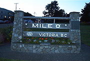
The Island section of Highway 1, which is 116 km (72 mi) in total length, begins at the intersection of Douglas StreetDouglas Street
Douglas Street is a road in Victoria, British Columbia. It is part of the Trans-Canada Highway and is named after Sir James Douglas, the second Governor of Vancouver Island....
and Dallas Road in Victoria, where a large "mile zero" sign is erected. Highway 1 proceeds north through the city of Victoria for 4 km (2½ mi), passing by the southern terminus of Highway 17, before leaving the city at Tolmie Avenue. Once out of Victoria there are three at grade intersections at Boleskine Rd, Tillicum Rd and Mckenzie Avenue. Between Tillicum and Mckenzie there is a limited interchange at Interurban (south bound off-ramp). Highway 1 then continues on a 10 km (6 mi) long four to six lane freeway, with four interchanges along its length, one of which leads to the start of Highway 14 until Spencer Rd in Langford. Currently, an interchange is being constructed which will extend the freeway to the last light out of Langford at Westshore Parkway. The highway narrows to two lanes upon its entry into Goldstream Provincial Park
Goldstream Provincial Park
Goldstream Provincial Park is a provincial park in British Columbia, Canada. It is known for the annual fall salmon runs in the Goldstream River, and the large numbers of bald eagles that congregate to feed at that time. The total size of the park is 3.79 square kilometres. It is located in the...
. The highway from this point is known locally as the Malahat
Malahat, British Columbia
Malahat or The Malahat refers to a First Nations people and the unincorporated locality, highway, and passenger train named after them on southern Vancouver Island...
.
From the southern entrance to Goldstream park, the Malahat section of the highway, which is known for its steep grades, goes north for 20 km (12 mi), becoming three lanes on its exit from Goldstream park and passing through the community of Malahat proper en route, until it reaches the community of Mill Bay
Mill Bay, British Columbia
Mill Bay is a commuter town of about 3,200 people located on Vancouver Island, British Columbia, Canada about north of Victoria, the capital.Mill Bay was founded in the 1860s with lumber and milling as its primary industries, done at the mill on the bay...
. Here it once again widens out into four lanes (with an interchange at Mill Bay Road), just south of signalized intersections at Frayne Road and Deloume Road. The Trans Canada Highway then travels north through a gauntlet of fifteen traffic lights for 29 km (18 mi). These provide access to Shawnigan Lake
Shawnigan Lake, British Columbia
Shawnigan Lake is a village on British Columbia's Vancouver Island. The name Shawnigan is an adaptation of the Hunquminum name for the Shawnigan Lake, the lake the village is situated at, Shaanii'us...
(stoplights at Shawnigan Lake Road), Cobble Hill
Cobble Hill, British Columbia
Cobble Hill is a small community on Vancouver Island, British Columbia, Canada. It is located approximately north of Victoria in the Cowichan Valley Regional District, and is known for its agricultural surroundings, and for Cobble Hill itself, which gave the village its name...
(Cobble Hill Road, Hutchinson Road and Fisher Road), Cowichan Bay
Cowichan Bay, British Columbia
Cowichan Bay is a bay and community located near Duncan, in British Columbia. The mouth of the Cowichan River is near Cowichan Bay. The bay is known for its fishing and scenic value...
(Cowichan Bay Road, Koksilah Road, and Bench Road) and Duncan
Duncan, British Columbia
Duncan is a city on southern Vancouver Island in British Columbia, Canada.-History:The community is named after William Chalmers Duncan . He arrived in Victoria in May 1862, then in August of that year he was one of the party of a hundred settlers which Governor Douglas took to Cowichan Bay...
(closely spaced signals at Allenby Road, Boys Road, Trunk Road, Coronation Avenue, James Street, Beverly Street, Green Road, and Drinkwater Road). Next is a signalized junction with Highway 18. The highway then proceeds north for 10 km (6 mi) through stoplights at Mays Road and Mount Sicker Road to a signalized intersection at Henry Road serving Chemainus
Chemainus, British Columbia
Chemainus is a community on the east coast of Vancouver Island, British Columbia, Canada.Founded as a logging town in 1858, the town is now famous for its 39 outdoor murals. This outdoor gallery has given birth to 300 businesses, including a theatre, antiques dealers, and eateries. The tourist...
.
From the Chemainus junction, Highway 1 travels 11 km (7 mi) northwest to the city of Ladysmith
Ladysmith, British Columbia
Ladysmith is a town located on the 49th parallel on the east coast of Vancouver Island British Columbia, Canada. The local economy is based on forestry, tourism and agriculture. A hillside location adjacent to a sheltered harbour form the natural characteristics of the community., the population...
accessed by intersections with traffic lights at Davis Road, Roberts Street, and Ludlow Road. It then continues northwest for another 13 km (8 mi)through signalized junctions at Oyster Road, Cedar Road, Timberlands Road, and Spitfire Way, the last of which provides access to Nanaimo Airport. The highway then reaches an unsignalized junction at Cassidy
Cassidy, British Columbia
Cassidy, British Columbia is located south of Nanaimo on Vancouver Island and is home to the Ray Collishaw Air Terminal, Nanaimo's only airfield. It is home to farms and is generally rural. Its proximity to Nanaimo means it provides a short commute for those looking to live away from town...
. Immeditately north of the Nanamio River Bridge there is an interchange to Nanaimo River Road. 6 km (4 mi) north of Cassidy, Highway 1 enters the city of Nanaimo, where Highway 19 merges onto the highway from the B.C. Ferry terminal at Duke Point
Duke Point, British Columbia
Duke Point is a geographical location in the extreme southeastern part of the city of Nanaimo in British Columbia. It is located on a thin peninsula to the east of the Nanaimo River estuary, just across the Northumberland Channel from Gabriola Island. Located at Duke Point is a major industrial...
. This short multiplex is a 2 km freeway 7 lanes wide at is widest point. 2 km north (1¼ mi), Highway 1 and Highway 19 split off at a junction with Cedar Road. Highway 19 proceeds west, while Highway 1 continues north. Highway 1 proceeds through the city of Nanaimo for 7 km (4 mi) north to the B.C. Ferry terminal at Departure Bay
Departure Bay, British Columbia
Departure Bay is a bay in central Nanaimo, British Columbia, on the east coast of Vancouver Island. The surrounding neighbourhood is also referred to as "Departure Bay"—once a settlement of its own, it was amalgamated into the City of Nanaimo in the 1970s .- Geography :The bay is framed to the...
, where the Island section of Highway 1 terminates.
The Trans-Canada Highway then enters Departure Bay proper via ferry, turning east-northeast to enter the Strait of Georgia
Strait of Georgia
The Strait of Georgia or the Georgia Strait is a strait between Vancouver Island and the mainland coast of British Columbia, Canada. It is approximately long and varies in width from...
just north of Newcastle Island. The downtown core of Vancouver is visible from the ferry as it approaches the entrance to Howe Sound. Highway 1 turns north-northeast just west of Passage Island to enter Queen Charlotte Channel, then rounds the Whytecliff Peninsula to enter the Horseshoe Bay ferry terminal, 57 km (30 nmi) from the Departure Bay dock.
Lower Mainland section
Lower Mainland
The Lower Mainland is a name commonly applied to the region surrounding and including Vancouver, British Columbia, Canada. As of 2007, 2,524,113 people live in the region; sixteen of the province's thirty most populous municipalities are located there.While the term Lower Mainland has been...
was first given the "1" designation in 1941. Highway 1's original alignment started out within the city limits of Vancouver
Vancouver
Vancouver is a coastal seaport city on the mainland of British Columbia, Canada. It is the hub of Greater Vancouver, which, with over 2.3 million residents, is the third most populous metropolitan area in the country,...
, and followed Kingsway from Vancouver to Surrey
Surrey, British Columbia
Surrey is a city in the province of British Columbia, Canada. It is a member municipality of Metro Vancouver, the governing body of the Greater Vancouver Regional District...
, and then went along the Fraser Highway to Clearbrook
Clearbrook, British Columbia
Clearbrook is a neighbourhood of the City of Abbotsford, British Columbia, located in the western portion of the city in the vicinity of Clearbrook Road. The area was originally known as Sandy Flats or West Abbotsford, and was located in the Poplar district of the Matsqui Municipality...
. From Chilliwack
Chilliwack, British Columbia
Chilliwack is a Canadian city in the Province of British Columbia. It is a predominantly agricultural community with an estimated population of 80,000 people. Chilliwack is the second largest city in the Fraser Valley Regional District after Abbotsford. The city is surrounded by mountains and...
, the highway originally went to Rosedale
Rosedale, British Columbia
Rosedale is a farming-based community located in Chilliwack, British Columbia. It serves as a base for many tourists, both in summer and winter. The hills and valleys of British Columbia are popular skiing, snowboarding and dogsledding locations...
, which is a community just east of Chilliwack, along Yale Road, then along Flood-Hope Road to where it picks up its current alignment just across the Fraser River
Fraser River
The Fraser River is the longest river within British Columbia, Canada, rising at Fraser Pass near Mount Robson in the Rocky Mountains and flowing for , into the Strait of Georgia at the city of Vancouver. It is the tenth longest river in Canada...
from Hope
Hope, British Columbia
Hope is a district municipality located at the confluence of the Fraser and Coquihalla rivers in the province of British Columbia, Canada. Hope is at the eastern end of both the Fraser Valley and the Lower Mainland region, and is at the southern end of the Fraser Canyon...
.
In 1959, Highway 1 was given an extension from within Vancouver to Horseshoe Bay by way of the Lions' Gate Bridge
Lions' Gate Bridge
The Lions Gate Bridge, officially known as the First Narrows Bridge, is a suspension bridge that crosses the first narrows of Burrard Inlet and connects the City of Vancouver, British Columbia, to the North Shore municipalities of the District of North Vancouver, the City of North Vancouver, and...
and Taylor Way in West Vancouver. In 1962, the section between Clearbrook and Chilliwack was re-routed to a new expressway.
In 1964, the Clearbrook-Rosedale section of Highway 1 was restored to its original alignment. Also in that year, a new expressway (or "freeway"), originally designated as Highway 401, opened up on Highway 1's current alignment between West Vancouver and Rosedale. The expressway became part of Highway 1 in 1973.
In 1986, Highway 1 between Chilliwack and Hope was improved to a freeway. Through the 1990s, all signals and intersections on Highway 1 through Greater Vancouver were removed, making the entire section of Highway 1 between Horseshoe Bay and Hope a freeway.
Route details
Highway 1's total length in the Lower Mainland is 170 km (106 mi). On the Mainland, the highway begins at the Horseshoe Bay ferry terminal in West Vancouver. From here to the Ironworkers Memorial Second Narrows CrossingIronworkers Memorial Second Narrows Crossing
The Ironworkers Memorial Second Narrows Crossing, also called the Ironworkers Memorial Bridge, is the second bridge constructed at the Second Narrows of Burrard Inlet in Vancouver, British Columbia, Canada...
, the highway is known locally as the Upper Levels Highway. There are nine interchanges on the 14 km (9 mi) stretch of the Highway within West Vancouver. The first interchange east of Horseshoe Bay brings Highway 99 onto a common alignment
Concurrency (road)
A concurrency, overlap, or coincidence in a road network is an instance of one physical road bearing two or more different highway, motorway, or other route numbers...
with Highway 1. After Taylor Way, where Highway 99 takes the exit off Highway 1, the highway then crosses over the Capilano River
Capilano River
The Capilano River flows from north to south through the Coast Mountains on Vancouver's North Shore and empties into Burrard Inlet, opposite Stanley Park. The river is one of three primary sources of drinking water for residents of Greater Vancouver. The Cleveland Dam, built in 1954, impounds a...
into the District of North Vancouver
North Vancouver, British Columbia (district municipality)
The District of North Vancouver is a district municipality in British Columbia and is part of the GVRD. It surrounds the City of North Vancouver on three sides.-Geography:The District of North Vancouver is separated from Vancouver by Burrard Inlet...
. Highway 1 travels for 9 km (6 mi) through the District and the City of North Vancouver
North Vancouver, British Columbia (city)
The City of North Vancouver is a waterfront municipality on the north shore of Burrard Inlet, directly across from Vancouver, British Columbia. It is the smallest of the three North Shore municipalities, and the most urbanized as well...
, passing through seven interchanges, until crossing the 1292 m (4239 ft) long Ironworkers Memorial Second Narrows Crossing
Ironworkers Memorial Second Narrows Crossing
The Ironworkers Memorial Second Narrows Crossing, also called the Ironworkers Memorial Bridge, is the second bridge constructed at the Second Narrows of Burrard Inlet in Vancouver, British Columbia, Canada...
over the Burrard Inlet
Burrard Inlet
Burrard Inlet is a relatively shallow-sided coastal fjord in southwestern British Columbia, Canada. Formed during the last Ice Age, it separates the City of Vancouver and the rest of the low-lying Burrard Peninsula from the slopes of the North Shore Mountains, home to the communities of West...
into Vancouver. (The bridge, previously known as the Second Narrows Bridge, was renamed to honour the 27 workers who lost their lives during its construction.)
Cassiar Tunnel
The Cassiar Connector is a highway traffic tunnel on the Trans-Canada Highway. It is located in the north-east corner of Vancouver, British Columbia, near the Vancouver-Burnaby border....
and passes through three interchanges before crossing into Burnaby at the interchange with Boundary Road
Boundary Road (Vancouver/Burnaby)
Boundary Road is one of the most important traffic corridors in Metro Vancouver, British Columbia, Canada. It runs south from Burrard Inlet to the Fraser River separating Vancouver from Burnaby....
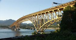
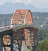
. The Burnaby stretch of Highway 1 is 11 km long (7 mi), and goes through four interchanges before proceeding into Coquitlam. The Coquitlam stretch of Highway 1 lasts 7 km (4 mi), with two interchanges along its length. The easternmost interchange on Highway 1 in Coquitlam leads to Highway 7. Once out of Coquitlam, Highway 1 crosses the Fraser River over the Port Mann Bridge
Port Mann Bridge
The Port Mann Bridge is a steel tied arch bridge that spans the Fraser River connecting Coquitlam to Surrey in British Columbia near Vancouver. The bridge consists of three spans with an orthotropic deck carrying five lanes of Trans-Canada Highway traffic, with approach spans of three steel plate...
into Surrey.
Sections of Highway 1 from the Grandview Highway to 152nd Street in Surrey vary from being 3 to 4 lanes in each direction, with one of these lanes being a high-occupancy vehicle (HOV) lane
High-occupancy vehicle lane
In transportation engineering and transportation planning, a high-occupancy vehicle lane is a lane reserved for vehicles with a driver and one or more passengers...
. These HOV lanes were constructed in 1998 as part of the BC MOT's "Go Green" project to promote the use of HOV vehicles, and cost 62 million dollars.
In Surrey, Highway 1 has three interchanges, the most easterly interchange of the three leading to Highway 15
British Columbia Highway 15
Highway 15 , known locally as the Pacific Highway, is a long north–south highway primarily located in the City of Surrey, British Columbia. The southern terminus is with Interstate 5 near Blaine, Washington as Washington State Route 543...
. 12 km (7 mi) east of the Highway's entry into Surrey, the Highway crosses into the Township of Langley
Langley, British Columbia (district municipality)
The Township of Langley is a district municipality immediately east of the City of Surrey in southwestern British Columbia, Canada. It extends south from the Fraser River to the U.S. border, and west of the City of Abbotsford...
. There are three interchanges on Highway 1 in its 18 km (11 mi) long stretch through Langley. One leads to 200 St., Langley's major thoroughfare, the second leads to Highway 10, and the third leads to Highway 13. Highway 1 then crosses from Metro Vancouver into the Fraser Valley Regional District
Fraser Valley Regional District
The Fraser Valley Regional District is a regional district in British Columbia, Canada. The FVRD covers an area of 13,361.74 km²...
on its entry into Abbotsford
Abbotsford, British Columbia
Abbotsford is a Canadian city located in the Lower Mainland of British Columbia, adjacent to Greater Vancouver. It is the fifth largest municipality in British Columbia, home to 123,864 people . Its Census Metropolitan Area, which includes the District of Mission, is the 23rd largest in Canada,...
. There are six interchanges on Highway 1 in its 33 km (21 mi) long stretch through Abbotsford, one of which leads to Highway 11. Once Highway 1 leaves Abbotsford, it crosses over the Vedder Canal into Chilliwack. The highway goes through Chilliwack for 24 km (15 mi), passing through five interchanges within the city (Yale Road E., Lickman Road, Vedder Road, Prest Road, and Annis Road).
2 km (1¼ mi) after leaving Chilliwack, Highway 1 reaches an interchange with Highway 9. East of the Highway 9 interchange, Highway 1 hugs the south bank of the Fraser River for 35 km (22 mi), passing through seven interchanges, until reaching the interchange with Highway 3
Crowsnest Highway
The Crowsnest Highway, also known as the Interprovincial or, in British Columbia, the Southern Trans-Provincial, is an east-west highway, in length, through the southern parts of British Columbia and Alberta, providing the shortest highway connection between British Columbia's Lower Mainland and...
at Hope. Highway 1 takes the exit off the freeway at this point. (The freeway alignments of Highways 3 and 5 continue from this exit, Exit 170, and continue unbroken until it meets up again with Highway 1 just west of Kamloops at Exit 362.) Most traffic traveling between Hope and Kamloops follow Highway 5 as it takes over an hour and a half less time to travel compared to following Highway 1.
Interior section
In the Kootenays, Highway 1 originally went around the Rogers Pass area in its section from RevelstokeRevelstoke, British Columbia
Revelstoke is a city in southeastern British Columbia, Canada. It is located east of Vancouver, and west of Calgary, Alberta. The city is situated on the banks of the Columbia River just south of the Revelstoke Dam and near its confluence with the Illecillewaet River...
to Golden
Golden, British Columbia
Golden is a town in southeastern British Columbia, Canada, located west of Calgary, Alberta and east of Vancouver.-History:Much of the town's history is tied into the Canadian Pacific Railway and the logging industry...
. In 1962, the section of Highway between Revelstoke and Golden was re-routed through Rogers Pass. Over the 1970s and 1980s, Highway 1's alignment between Hope and Cache Creek
Cache Creek, British Columbia
Cache Creek is a junction community northeast of Vancouver in British Columbia, Canada. It is on the Trans-Canada Highway in the province of British Columbia at its junction with northbound Highway 97...
underwent a massive overhaul, including new tunnels and river spans. In Kamloops, a new bypass was constructed to re-route traffic on Highway 1 around the downtown area of the city.
Route details
The Interior section of Highway 1 is 695 km (432 mi) long, and closely follows the path of the Canadian Pacific RailwayCanadian Pacific Railway
The Canadian Pacific Railway , formerly also known as CP Rail between 1968 and 1996, is a historic Canadian Class I railway founded in 1881 and now operated by Canadian Pacific Railway Limited, which began operations as legal owner in a corporate restructuring in 2001...
. After leaving the freeway, Highway 1 courses through the town centre of Hope for 2 km (1¼ mi) before heading north across the Fraser River. At this point, Highway 1 becomes two lanes. 1 km (about ½ mi) north of the Fraser crossing, Highway 1 reaches its east junction with Highway 7. Continuing from the Highway 7 junction, Highway 1 goes 106 km (66 mi) north on a route that includes seven mountain tunnels, past the communities of Yale
Yale, British Columbia
Yale is an unincorporated town in the Canadian province of British Columbia. It was founded in 1848 by the Hudson's Bay Company as Fort Yale by Ovid Allard, the appointed manager of the new post, who named it after his superior, James Murray Yale, then Chief Factor of the Columbia District...
, Spuzzum
Spuzzum, British Columbia
Spuzzum is an unincorporated settlement in British Columbia, Canada. Because it is on the Trans-Canada Highway, approximately 50 km north of the community of Hope, it is often referred to as being "beyond Hope"...
and Boston Bar
Boston Bar, British Columbia
Boston Bar is an unincorporated town in the Fraser Canyon of the Canadian province of British Columbia. It was not named for an organization of Massachusetts lawyers but dates from the time of the Fraser Canyon Gold Rush...
, before reaching its junction with Highway 12 at Lytton
Lytton, British Columbia
Lytton in British Columbia, Canada, sits at the confluence of the Thompson River and Fraser River on the east side of the Fraser. The location has been inhabited by the Nlaka'pamux people for over 10,000 years, and is one of the earliest locations settled by non-natives in the Southern Interior of...
. Leaving the Fraser River, and following the Thompson River
Thompson River
The Thompson River is the largest tributary of the Fraser River, flowing through the south-central portion of British Columbia, Canada. The Thompson River has two main branches called the South Thompson and the North Thompson...
another 37 km (23 mi) northeast, Highway 1 reaches a junction with another numbered route, Highway 8. 38 km (24 mi) north of the Highway 8 junction, Highway 1 passes through a junction with Highway 97C. Continuing 5 km (3 mi) north, the highway reaches the community of Cache Creek
Cache Creek, British Columbia
Cache Creek is a junction community northeast of Vancouver in British Columbia, Canada. It is on the Trans-Canada Highway in the province of British Columbia at its junction with northbound Highway 97...
, where Highway 97 merges onto the Trans-Canada from the north.
East of Cache Creek, Highways 1 and 97 proceed on their common alignment
Concurrency (road)
A concurrency, overlap, or coincidence in a road network is an instance of one physical road bearing two or more different highway, motorway, or other route numbers...
for 72 km (45 mi), passing through Savona
Savona, British Columbia
Savona is a small community located at the west end of Kamloops Lake, where the Thompson River exits it. It is approximately halfway between Kamloops and Cache Creek along the Trans-Canada Highway...
en route to Kamloops. Highway 5 merges onto the Trans-Canada from the south at this point, returning the freeway to Highway 1.
The 1/97/5 concurrency proceeds east for 12 km (7 mi) on a freeway through the western part of Kamloops to where Highway 5 diverges north. Highways 1 and 97 leave Kamloops to the east 7 km (4 mi) later. The highway continues east for another 19 km (12 mi) to Monte Creek
Monte Creek, British Columbia
Monte Creek is a rural locality on the South Thompson River east of Kamloops, British Columbia, Canada, approximately equidistant from Kamloops and the village of Chase, British Columbia. It is mostly notable as a major highway junction where British Columbia Highway 97 branches off from the...
, where the freeway ends and Highway 97 diverges south from Highway 1. For the next 82 km (51 mi) east, Highway 1 takes a winding two-lane route through the communities of Pritchard
Pritchard, British Columbia
Pritchard is a small community located in the interior of British Columbia, Canada. It has a population of roughly 2,000, and its main industries are farming and tourism. Pritchard is located on The Trans-Canada Highway between Kamloops, British Columbia and Chase, British Columbia, near the Hwy...
, Chase
Chase, British Columbia
Chase is a village located in the Interior of British Columbia, Canada. It has a population of roughly 2,500, and its main industries are forestry and tourism. It is located at the outlet of Little Shuswap Lake, which is the source of the South Thompson River...
and Sorrento
Sorrento, British Columbia
Sorrento is an unincorporated settlement located on the south shore of Shuswap Lake in the Southern Interior of the Canadian province of British Columbia. It is located on the Trans-Canada Highway, and is 16 miles northeast of the town of Chase and 28 miles northwest of the city of Salmon Arm...
before reaching the city of Salmon Arm
Salmon Arm, British Columbia
-Climate:- Education :Public schools in Salmon Arm are part of School District 83 North Okanagan-Shuswap; within the city limits, there are currently five elementary schools , one middle school , and a secondary school with two campuses...
on Shuswap Lake
Shuswap Lake
Shuswap Lake is a lake located in south-central British Columbia, Canada that drains via the Little River into Little Shuswap Lake. Little Shuswap Lake is the source of the South Thompson River, a branch of the Thompson River, a tributary of the Fraser River...
. Highway 97B meets Highway 1 in Salmon Arm.
Sicamous, British Columbia
Sicamous, British Columbia is a town in British Columbia located adjacent to the Trans-Canada Highway at the Highway 97A junction of Mara Lake and the Shuswap Lake system. It is known as a popular all season tourist destination attracting visitors from throughout Canada and around the world...
. Over the next 71 km (44 mi) east, Highway 1 winds through the communities of Malakwa
Malakwa, British Columbia
Malakwa is a settlement in the Southern Interior of British Columbia, Canada, in the Eagle River valley, along the Trans-Canada Highway between Sicamous and Revelstoke. It had a population of 649 people in 2001....
, Craigellachie
Craigellachie, British Columbia
Craigellachie is a locality in British Columbia, located several kilometres to the west of the Eagle Pass summit between Sicamous and Revelstoke...
and the Three Valley Gap
Three Valley Gap, British Columbia
Three Valley Gap is an unincorporated settlement and small resort and heritage-themed amusement park on the Trans-Canada Highway located on and adjacent to the lake of the same name, southwest of Revelstoke just west of the summit of Eagle Pass...
, before reaching its junction with Highway 23 at Revelstoke
Revelstoke, British Columbia
Revelstoke is a city in southeastern British Columbia, Canada. It is located east of Vancouver, and west of Calgary, Alberta. The city is situated on the banks of the Columbia River just south of the Revelstoke Dam and near its confluence with the Illecillewaet River...
, on the Columbia River
Columbia River
The Columbia River is the largest river in the Pacific Northwest region of North America. The river rises in the Rocky Mountains of British Columbia, Canada, flows northwest and then south into the U.S. state of Washington, then turns west to form most of the border between Washington and the state...
. The next 148 km (92 mi) of Highway 1 to Golden
Golden, British Columbia
Golden is a town in southeastern British Columbia, Canada, located west of Calgary, Alberta and east of Vancouver.-History:Much of the town's history is tied into the Canadian Pacific Railway and the logging industry...
winds east through Mount Revelstoke National Park
Mount Revelstoke National Park
Mount Revelstoke National Park is located adjacent to the city of Revelstoke, British Columbia, Canada. The park is relatively small for a national park, covering 260 square kilometres. It is located in the Selkirk Mountains and was founded in 1914...
and Glacier National Park
Glacier National Park (Canada)
Glacier National Park is one of seven national parks in British Columbia, and is part of a system of 43 parks and park reserves across Canada. It protects a portion of the Columbia Mountains. It also contains the Rogers Pass National Historic Site, designated for its importance in the construction...
, where the Rogers Pass
Rogers Pass
Rogers Pass is a high mountain pass through the Selkirk Mountains of British Columbia used by the Canadian Pacific Railway and the Trans-Canada Highway. The pass is a shortcut across the "Big Bend" of the Columbia River from Revelstoke on the west to Donald, near Golden, on the east...
area is located. There are eight snow shed
Snow shed
An avalanche snow bridge or simply snow bridge is a type of rigid snow-supporting structure for avalanche control . Avalanche bridges can be made of steel, prestressed concrete frames, or timber....
s on Highway 1 between Revelstoke and Golden—three of them lie west of Rogers Pass, while five lie to the east.
After Glacier National Park and a time zone
Time zone
A time zone is a region on Earth that has a uniform standard time for legal, commercial, and social purposes. In order for the same clock time to always correspond to the same portion of the day as the Earth rotates , different places on the Earth need to have different clock times...
boundary crossing, Highway 1 passes over the Columbia River again at Donald
Donald, British Columbia
Donald, British Columbia is located on Highway 1, 28 kilometers west of Golden. In its heyday, Donald was a divisional point on the Canadian Pacific Railway...
, and then reaches its junction with Highway 95 at Golden. 73 km (45 mi) east of Golden, after Highway 1 has passed through Yoho National Park
Yoho National Park
Yoho National Park is located in the Canadian Rocky Mountains along the western slope of the Continental Divide in southeastern British Columbia. Yoho NP is bordered by Kootenay National Park on the southern side and Banff National Park on the eastern side...
and the community of Field
Field, British Columbia
Field is an unincorporated settlement of approximately 300 people located in the Kicking Horse River valley of southeastern British Columbia,Canada, within the confines of Yoho National Park....
, Highway 1 crosses the Continental Divide
Continental Divide
The Continental Divide of the Americas, or merely the Continental Gulf of Division or Great Divide, is the name given to the principal, and largely mountainous, hydrological divide of the Americas that separates the watersheds that drain into the Pacific Ocean from those river systems that drain...
(via Kicking Horse Pass
Kicking Horse Pass
Kicking Horse Pass is a high mountain pass across the Continental Divide of the Americas of the Canadian Rockies on the Alberta/British Columbia border, and lying within Yoho and Banff National Parks...
) into Alberta
Alberta
Alberta is a province of Canada. It had an estimated population of 3.7 million in 2010 making it the most populous of Canada's three prairie provinces...
.
Exit list
| Division | Location | km | Exit | Destinations | Notes |
|---|---|---|---|---|---|
| Capital Regional District | Continues as Douglas Street towards Victoria City Centre | ||||
| City of Saanich Saanich, British Columbia The District of Saanich is a municipality on Vancouver Island in British Columbia. It is located north of the provincial capital, Victoria. It has a population of 108,265 people, making it the most populous municipality on Vancouver Island, and the seventh most populous in the province... |
0.91 | Carey Road | At-grade intersection | ||
| 1.20 | Harriet Road | At-grade intersection, right in right out Right-in/right-out Right-in/right-out and left-in/left-out refer to a type of road intersection where turning movements of vehicles are restricted. A RIRO permits only right turns and a LILO permits only left turns. RIRO is usual where vehicles drive on the right, and LILO is usual where vehicles drive on the left... |
|||
| 1.94 | Tillicum Road | At-grade intersection | |||
| Burnside Road | Eastbound only | ||||
| 3.02 | 6 | McKenzie Avenue, Admirals Road | At-grade intersection | ||
| Town of View Royal View Royal, British Columbia View Royal is a town in Greater Victoria and a member municipality of the Capital Regional District of British Columbia, Canada. View Royal has a population of approximately 8000 residents and was incorporated as a municipality in December 1988.... |
5.09 | 8 | Helmcken Road | ||
| 6.80 | 10 | , Burnside Road | Westbound exit, Eastbound entrance | ||
| 7.74 | 11 | Six Mile Road | Eastbound exit, Westbound entrance | ||
| City of Langford Langford, British Columbia Langford is a city of 22,459 residents on southern Vancouver Island, within the province of British Columbia, Canada. It is considered one of Greater Victoria's Western Communities... |
10.79 | 14 | |||
| 11.54 | Spencer Road | To be closed upon completion of the Bear Mountain interchange | |||
| Bear Mountain Parkway, Leigh Road | New interchange planned | ||||
| Cowichan Valley Regional District Cowichan Valley Regional District, British Columbia The Cowichan Valley Regional District is a regional district in the Canadian province of British Columbia is on the southern part of Vancouver Island, bordered by the Nanaimo and Alberni-Clayoquot Regional Districts to the north and northwest, and by the Capital Regional District to the south and... |
City of Duncan Duncan, British Columbia Duncan is a city on southern Vancouver Island in British Columbia, Canada.-History:The community is named after William Chalmers Duncan . He arrived in Victoria in May 1862, then in August of that year he was one of the party of a hundred settlers which Governor Douglas took to Cowichan Bay... |
57.85 | Trunk Road | Signalized at-grade intersection with no right turn lanes | |
| 63.56 | |||||
| Nanaimo Regional District | |||||
| 96.89 | (102) | Nanaimo River Road, Fry Road | |||
| 99.02 | Morden Road | At-grade intersection | |||
| 99.41 | South Wellington Road | Southbound Right-in, right-out | |||
| 100.16 | Minetown Road | Southbound Right-in, right-out | |||
| 100.47 | Kipp Road, Fielding Road | At-grade intersection | |||
| City of Nanaimo Nanaimo, British Columbia Nanaimo is a city on Vancouver Island in British Columbia, Canada. It has been dubbed the "Bathtub Racing Capital of the World" and "Harbour City". Nanaimo is also sometimes referred to as the "Hub City" because of its central location on Vancouver Island and due to the layout of the downtown... |
101.25 | (106) | via Ferries | ||
| 102.72 | (107) | , Cedar Road | End of Highway 19 overlap, partial-at grade intersection with northbound flyover to Highway 19 north | ||
| Continues as Island Highway, Nicol Street, Terminal Avenue, and Stewart Avenue within Nanaimo Nanaimo, British Columbia Nanaimo is a city on Vancouver Island in British Columbia, Canada. It has been dubbed the "Bathtub Racing Capital of the World" and "Harbour City". Nanaimo is also sometimes referred to as the "Hub City" because of its central location on Vancouver Island and due to the layout of the downtown... |
|||||
| BC Ferries BC Ferries British Columbia Ferry Services Inc. or BC Ferries is a de facto Crown Corporation that provides all major passenger and vehicle ferry services for coastal and island communities in the Canadian province of British Columbia... across the Strait of Georgia Strait of Georgia The Strait of Georgia or the Georgia Strait is a strait between Vancouver Island and the mainland coast of British Columbia, Canada. It is approximately long and varies in width from... |
|||||
| Metro Vancouver | District of West Vancouver | 0.35 | Keith Road | At-grade intersection | |
| 0.61 | 0 | Marine Drive |
|
||
| 1.84 | 2 | Eagleridge Drive |
|
||
| 2.21 | 3 |
|
|||
| 4.29 | 4 | Headlands Drive, Westport Road | |||
| 6.95 | 7 | Westmount Road, Wentworth Avenue | |||
| 8.54 | 8 | Cypress Bowl Road | |||
| 10.59 | 10 | 22nd Street, 21st Street, Westhill Drive | |||
| 11.46 | 11 | 15th Street | |||
| 13.15 | 13 | , Seattle |
|
||
| District of North Vancouver North Vancouver, British Columbia (district municipality) The District of North Vancouver is a district municipality in British Columbia and is part of the GVRD. It surrounds the City of North Vancouver on three sides.-Geography:The District of North Vancouver is separated from Vancouver by Burrard Inlet... |
14.75 | 14 | Capilano Road | ||
| 15.51 | 15 | Lloyd Avenue | Westbound Right-in right-out | ||
| City of North Vancouver North Vancouver, British Columbia (city) The City of North Vancouver is a waterfront municipality on the north shore of Burrard Inlet, directly across from Vancouver, British Columbia. It is the smallest of the three North Shore municipalities, and the most urbanized as well... |
16.75 | 17 | Westview Drive | ||
| 17.92 | 18 | Lonsdale Avenue, 25th Avenue | |||
| District of North Vancouver North Vancouver, British Columbia (district municipality) The District of North Vancouver is a district municipality in British Columbia and is part of the GVRD. It surrounds the City of North Vancouver on three sides.-Geography:The District of North Vancouver is separated from Vancouver by Burrard Inlet... |
19.49 | 19 | Lynn Valley Road, William Avenue, Boulevard Crescent | ||
| 21.37 | 21 | Mountain Highway | Westbound exit only | ||
| 22.17 | 22 | Mount Seymour Parkway, Fern Street | |||
| 22.88 | 23 | Main Street, Dollarton Highway | Signed as exits 23A Main Street and 23B Dollarton Highway westbound, on westbound Highway 1 | ||
| Ironworkers Memorial Second Narrows Crossing Ironworkers Memorial Second Narrows Crossing The Ironworkers Memorial Second Narrows Crossing, also called the Ironworkers Memorial Bridge, is the second bridge constructed at the Second Narrows of Burrard Inlet in Vancouver, British Columbia, Canada... over Burrard Inlet Burrard Inlet Burrard Inlet is a relatively shallow-sided coastal fjord in southwestern British Columbia, Canada. Formed during the last Ice Age, it separates the City of Vancouver and the rest of the low-lying Burrard Peninsula from the slopes of the North Shore Mountains, home to the communities of West... |
|||||
| City of Vancouver Vancouver Vancouver is a coastal seaport city on the mainland of British Columbia, Canada. It is the hub of Greater Vancouver, which, with over 2.3 million residents, is the third most populous metropolitan area in the country,... |
24.63 | 25 | McGill Street | ||
| 24.63 | 26 | Hastings Street | Eastbound exit, westbound entrance; exits onto Cassiar Street | ||
| Cassiar Tunnel Cassiar Tunnel The Cassiar Connector is a highway traffic tunnel on the Trans-Canada Highway. It is located in the north-east corner of Vancouver, British Columbia, near the Vancouver-Burnaby border.... north entrance |
|||||
| Bridgeway Street | At-grade intersection, collector/distributor | ||||
| Hastings Street | At-grade intersection, collector/distributor | ||||
| Cassiar Tunnel south entrance | |||||
| 26.32 | 26 | Hastings Street | Westbound exit, westbound entrance | ||
| 27.06 | 27 | 1st Avenue, Rupert Street | |||
| 28.02 | 28A | Boundary Road | Eastbound exit to southbound Boundary Road, and westbound entrance from northbound Boundary Road | ||
| City of Burnaby | Grandview Highway overpass | New overpass with dedicated exit/entrance to/from HOV lanes planned; | |||
| 28.99 | 28A | Westbound exit to Grandview Highway | |||
| 29.44 | 29A | Willingdon Avenue southbound | Entrance to Highway 1 westbound use C/D road, interchange to be reconfigured | ||
| 29.74 | 29B | Willingdon Avenue northbound | Interchange to be reconfigured | ||
| 30 | Commercial-vehicle-only exit to Douglas Road | Westbound exit, eastbound entrance only | |||
| 32.26 | 32 | Sprott Street | Eastbound exit, westbound entrance only | ||
| 32.92 | 33 | Kensington Avenue, Canada Way | Interchange to be reconfigured | ||
| 37.32 | 37 | Gaglardi Way | Interchange to be reconfigured | ||
| Government Street | New transit-only interchange planned | ||||
| City of Coquitlam | 40.54 | 40A/40B | Brunette Avenue | Interchange to be reconfigured | |
| 43.92 | 44 | No direct access to Highway 1 westbound from 7 westbound, interchange to be reconfigured | |||
| 43.92 | 44 | , United Boulevard | Interchange to be reconfigured, Eastbound exit, westbound entrance only | ||
| Port Mann Bridge Port Mann Bridge The Port Mann Bridge is a steel tied arch bridge that spans the Fraser River connecting Coquitlam to Surrey in British Columbia near Vancouver. The bridge consists of three spans with an orthotropic deck carrying five lanes of Trans-Canada Highway traffic, with approach spans of three steel plate... over Fraser River Fraser River The Fraser River is the longest river within British Columbia, Canada, rising at Fraser Pass near Mount Robson in the Rocky Mountains and flowing for , into the Strait of Georgia at the city of Vancouver. It is the tenth longest river in Canada... , new Port Mann Bridge under construction |
|||||
| City of Surrey Surrey, British Columbia Surrey is a city in the province of British Columbia, Canada. It is a member municipality of Metro Vancouver, the governing body of the Greater Vancouver Regional District... |
48.32 | 48 | 152nd Street, 108th Avenue | Eastbound exit, westbound entrance, interchange to be reconfigured | |
| 156th Street | New HOV-only interchange planned | ||||
| 50.14 | 50 | 104th Avenue, 160th Street | Interchange to be reconfigured | ||
| 53.49 | 53 | , Blaine, WA South Fraser Perimeter Road South fraser perimeter road The South Fraser Perimeter Road is a $1.0 billion highway project for Metro Vancouver and is part of the British Columbia Ministry of Transportation's Gateway Program and is currently under construction.-Project scope and goals:... (under construction) to Delta Delta, British Columbia Delta is a district municipality in British Columbia, and forms part of Metro Vancouver. Located south of Richmond, it is bordered by the Fraser River to the north, the United States to the south and the city of Surrey to the east... |
Interchange to be reconfigured | ||
| 56.79 | 57 | 192nd Street northbound | Eastbound exit, westbound entrance; No access to/from 192nd Street south of interchange | ||
| Township of Langley Langley, British Columbia (district municipality) The Township of Langley is a district municipality immediately east of the City of Surrey in southwestern British Columbia, Canada. It extends south from the Fraser River to the U.S. border, and west of the City of Abbotsford... |
58.71 | 58 | 200th Street | Access to the Golden Ears Bridge Golden Ears Bridge The Golden Ears Bridge is a six-lane extradosed bridge in Metro Vancouver, British Columbia. It spans the Fraser River, connecting Langley on the south side with Pitt Meadows and Maple Ridge on the north side. The All Electronic Toll bridge, owned by TransLink, has a clearance of , and a total... |
|
| 216th Street | New interchange planned | ||||
| 65.73 | 66 | ||||
| 73.25 | 73 | , Bellingham, WA; 56th Avenue | |||
| Fraser Valley Regional District Fraser Valley Regional District The Fraser Valley Regional District is a regional district in British Columbia, Canada. The FVRD covers an area of 13,361.74 km²... |
City of Abbotsford Abbotsford, British Columbia Abbotsford is a Canadian city located in the Lower Mainland of British Columbia, adjacent to Greater Vancouver. It is the fifth largest municipality in British Columbia, home to 123,864 people . Its Census Metropolitan Area, which includes the District of Mission, is the 23rd largest in Canada,... |
78.32 | Rest area | Westbound only | |
| 82.77 | 83 | Mount Lehman Road | Eastbound exit, westbound entrance | ||
| 83.16 | 83 | Fraser Highway/Maclure Road | |||
| 86.77 | 87 | Clearbrook Road | |||
| 90.02 | 90 | McCallum Road/King Road | |||
| 92.03 | 92 | , Sumas, WA | |||
| 95.46 | 95 | Whatcom Road | |||
| 98.65 | 99 | South Parallel Road | Westbound only, to rest area | ||
| Atkinson Road, North Parallel Road | Eastbound entrance only | ||||
| 104.44 | 104 | No. 3 Road | |||
| City of Chilliwack Chilliwack, British Columbia Chilliwack is a Canadian city in the Province of British Columbia. It is a predominantly agricultural community with an estimated population of 80,000 people. Chilliwack is the second largest city in the Fraser Valley Regional District after Abbotsford. The city is surrounded by mountains and... |
109.86 | 109 | Yale Road | ||
| 115.94 | 116 | Lickman Road | |||
| 119.24 | 119 | Vedder Road | |||
| 120.38 | 120 | Young Road | Westbound exit, eastbound entrance | ||
| 122.64 | 123 | Prest Road | |||
| 129.07 | 129 | Annis Road/Hack Brown Road | |||
| Fraser Valley Electoral Area D Fraser Valley Regional District The Fraser Valley Regional District is a regional district in British Columbia, Canada. The FVRD covers an area of 13,361.74 km²... |
135.12 | 135 | / Bridal Falls Road | ||
| 138.19 | 138 | Yale Road/Bridal Falls Road | |||
| 142.96 | U-turn slip | Left exit - located in median | |||
| 143.99 | Wahleach Access Road | Access road to power substation; EB only | |||
| 146.32 | 146 | Herrling Island | Access road to Herrling Island; also U-turn area | ||
| 149.78 | CNR Frontage Road | Westbound slip-ramp | |||
| Fraser Valley Electoral Area B Fraser Valley Regional District The Fraser Valley Regional District is a regional district in British Columbia, Canada. The FVRD covers an area of 13,361.74 km²... |
151.33 | 151 | Peters Road to Peters Indian Reserve | ||
| 153.51 | 153 | Laidlaw Road to Wahleach Lake | |||
| Municipality of Hope Hope, British Columbia Hope is a district municipality located at the confluence of the Fraser and Coquihalla rivers in the province of British Columbia, Canada. Hope is at the eastern end of both the Fraser Valley and the Lower Mainland region, and is at the southern end of the Fraser Canyon... |
159.85 | 160 | Hunter Creek Road, St. Elmo Road, Laidlaw Road | ||
| 164.53 | 165 | Flood-Hope Road, Hope Hope, British Columbia Hope is a district municipality located at the confluence of the Fraser and Coquihalla rivers in the province of British Columbia, Canada. Hope is at the eastern end of both the Fraser Valley and the Lower Mainland region, and is at the southern end of the Fraser Canyon... Business Route |
|||
| 167.75 | 168 | Flood-Hope Road, Tobina Road | |||
| 170.10 | 170 | No direct ramp from Hwy 1 west to Hwy 3 east | |||
| Highway 1 exits freeway, continues as 4-lane arterial road thru Hope Hope, British Columbia Hope is a district municipality located at the confluence of the Fraser and Coquihalla rivers in the province of British Columbia, Canada. Hope is at the eastern end of both the Fraser Valley and the Lower Mainland region, and is at the southern end of the Fraser Canyon... |
|||||
| 172.98 | Haig Station Road/Landstrom Road | At-grade intersection | |||
| 173.99 | |||||
|
|-
|rowspan=2|Thompson-Nicola Regional District
Thompson-Nicola Regional District, British Columbia
The Thompson-Nicola Regional District is a regional district in the Canadian province of British Columbia. The Canada 2006 Census population was 122,286 and the area covers 45,279 square kilometres. The administrative offices are in the main population centre is the city of Kamloops, which...
|Village of Lytton
Lytton, British Columbia
Lytton in British Columbia, Canada, sits at the confluence of the Thompson River and Fraser River on the east side of the Fraser. The location has been inhabited by the Nlaka'pamux people for over 10,000 years, and is one of the earliest locations settled by non-natives in the Southern Interior of...
|279.33
|
|
|At-grade intersection
|-
|
|315.02
|
|
|At-grade intersection
|-
|rowspan=2|Cariboo Regional District
Cariboo Regional District, British Columbia
The Cariboo Regional District spans the towns of Quesnel, Williams Lake, 100 Mile House, and Wells in the Central Interior of British Columbia.The Canada 2006 Census population was 62,190 persons living on a land area of 80,629.34 km²...
|
|360.08
|
|
|At-grade intersection
|-
|
|bgcolor=#ddffdd|364.66
|bgcolor=#ddffdd|
|bgcolor=#ddffdd|
|bgcolor=#ddffdd|At-grade intersection; Begin BC 1 and BC 97 overlap
|-
|rowspan=30|Thompson-Nicola Regional District
Thompson-Nicola Regional District, British Columbia
The Thompson-Nicola Regional District is a regional district in the Canadian province of British Columbia. The Canada 2006 Census population was 122,286 and the area covers 45,279 square kilometres. The administrative offices are in the main population centre is the city of Kamloops, which...
|rowspan=26|City of Kamloops
|colspan=4 align=center|Highway 1 enters freeway
|-
|bgcolor=#ddffdd|436.65
|bgcolor=#ddffdd|362
|bgcolor=#ddffdd|
|bgcolor=#ddffdd|Begins overlap with BC 5
|-
|440.88
|366
|Copperhead Drive
|
|-
|442.56
|367
|Hugh Allan Drive; Pacific Way
|
|-
|443.35
|368
|, Hillside Way
|
|-
|444.30
|369
|Columbia Street; Notre-Dame Drive
|EB exit, WB entrance
|-
|445.23
|370
|Summit Drive; Notre-Dame Drive
|WB exit, EB entrance
|-
|bgcolor=#ddffdd|448.72
|bgcolor=#ddffdd|374
|bgcolor=#ddffdd|, Jasper
Jasper, Alberta
Jasper is a specialized municipality in western Alberta, Canada. It is the commercial centre of Jasper National Park, located in the Canadian Rockies in the Athabasca River valley....
, Edmonton
Edmonton
Edmonton is the capital of the Canadian province of Alberta and is the province's second-largest city. Edmonton is located on the North Saskatchewan River and is the centre of the Edmonton Capital Region, which is surrounded by the central region of the province.The city and its census...
|bgcolor=#ddffdd|End BC 5 overlap
|-
|449.17
|
|Battle Street
|No eastbound exit, freeway ends
|-
|449.72
|
|Comazzetto Road
|At-grade intersection
|-
|450.40
|
|Vicars Road
|At-grade intersection, signalized
|-
|451.23
|
|Oriole Road
|At-grade intersection, signalized
|-
|452.04
|
|Highland Road
|At-grade intersection, signalized
|-
|452.78
|
|River Road
|At-grade intersection, signalized
|-
|453.73
|
|Tanager Road
|At-grade intersection, signalized
|-
|454.59
|
|Grand Boulevard
|At-grade intersection, signalized
|-
|455.19
|
|Grand Boulevard
|At-grade intersection, eastbound only
|-
|456.23
|
|Holman Road
|At-grade intersection
|-
|457.38
|
|Dallas Drive
|Eastbound right in, right out
|-
|457.78
|
|Nina Place
|Westbound exit only
|-
|460.38
|
|Pat Road
|At-grade intersection
|-
|462.45
|388
|Kokanee Way
|
|-
|465.10
|
|Unnamed access road
|Westbound right in, right out
|-
|465.68
|390
|Dallas Drive
|Eastbound entrance and exit
|-
|466.14
|391
|Lafarge Road
|Westbound entrance and exit
|-
|472.17
|397
|Hook Road
|
|-
|rowspan=3|Thompson-Nicola Electoral Area L
|bgcolor=#ddffdd|474.72
|bgcolor=#ddffdd|399
|bgcolor=#ddffdd|
|bgcolor=#ddffdd|End BC 1 and BC 97 overlap
|-
|bgcolor=#ffdddd|477.48
|bgcolor=#ffdddd|
|bgcolor=#ffdddd|Bostock Road
|bgcolor=#ffdddd|At-grade intersection, to be relocated fall 2012
|-
|478.54
|
|Rocky Point Road
|At-grade intersection, to be closed fall 2012
|-
|
|colspan=4 align=center|Highway 1 continues as 2-lane highway
|-
|rowspan=20|Columbia-Shuswap Regional District
Columbia-Shuswap Regional District, British Columbia
The Columbia-Shuswap Regional District is a regional district in the Canadian province of British Columbia, located in the Southern Interior region on the Trans-Canada Highway between Vancouver and Calgary...
|rowspan=8|Columbia-Shuswap Electoral Area C
Columbia-Shuswap Regional District, British Columbia
The Columbia-Shuswap Regional District is a regional district in the Canadian province of British Columbia, located in the Southern Interior region on the Trans-Canada Highway between Vancouver and Calgary...
|527.43
|
|Hilltop Road
|At-grade intersection
|-
|528.53
|
|Cedar Drive, Highland Drive
|
|-
|529.97
|
|Greer Road
|At-grade intersection
|-
|532.14
|
|Balmoral Road
|At-grade intersection, interchange planned
|-
|534.62
|
|Wuori Road, Carlin Road
|Right in, right out
|-
|535.75
|
|White Lake Road, Carlin Road
|Right in, right out
|-
|538.19
|
|Ford Road
|At-grade intersection
|-
|colspan=4 align=center|Highway 1 continues as 2-lane highway
|-
|City of Salmon Arm
Salmon Arm, British Columbia
-Climate:- Education :Public schools in Salmon Arm are part of School District 83 North Okanagan-Shuswap; within the city limits, there are currently five elementary schools , one middle school , and a secondary school with two campuses...
|560.15
|
|
|At-grade intersection
|-
|District of Sicamous
Sicamous, British Columbia
Sicamous, British Columbia is a town in British Columbia located adjacent to the Trans-Canada Highway at the Highway 97A junction of Mara Lake and the Shuswap Lake system. It is known as a popular all season tourist destination attracting visitors from throughout Canada and around the world...
|586.99
|
|
|At-grade intersection
|-
|rowspan=3|City of Revelstoke
Revelstoke, British Columbia
Revelstoke is a city in southeastern British Columbia, Canada. It is located east of Vancouver, and west of Calgary, Alberta. The city is situated on the banks of the Columbia River just south of the Revelstoke Dam and near its confluence with the Illecillewaet River...
|bgcolor=#ddffdd|656.92
|bgcolor=#ddffdd|
|bgcolor=#ddffdd|
|bgcolor=#ddffdd|Begin BC 23 overlap; At-grade intersection
|-
|bgcolor=#ddffdd|658.20
|bgcolor=#ddffdd|
|bgcolor=#ddffdd|
|bgcolor=#ddffdd|End BC 23 overlap; At-grade intersection
|-
|659.25
|
|Meadows-in-the-Sky Parkway, Mount Revelstoke National Park
Mount Revelstoke National Park
Mount Revelstoke National Park is located adjacent to the city of Revelstoke, British Columbia, Canada. The park is relatively small for a national park, covering 260 square kilometres. It is located in the Selkirk Mountains and was founded in 1914...
|
|-
|rowspan=3|Municipality of Golden
Golden, British Columbia
Golden is a town in southeastern British Columbia, Canada, located west of Calgary, Alberta and east of Vancouver.-History:Much of the town's history is tied into the Canadian Pacific Railway and the logging industry...
|colspan=4 align=center|Expressway begins
|-
|806.13
|
|
|At-grade intersection, interchange planned
|-
|bgcolor=#ffdddd|807.53
|bgcolor=#ffdddd|
|bgcolor=#ffdddd|Golden Donald Upper Road, Golden View Road
|bgcolor=#ffdddd|Interchange under construction
|-
|rowspan=3|Columbia-Shuswap Electoral Area A
Columbia-Shuswap Regional District, British Columbia
The Columbia-Shuswap Regional District is a regional district in the Canadian province of British Columbia, located in the Southern Interior region on the Trans-Canada Highway between Vancouver and Calgary...
|817.81
|
|Rest Area
|At-grade intersection
|-
|822.68
|
|Glenogle Creek Forest Service Road, Brake Check
|At-grade intersection with westbound exit ramp
|-
|831.19
|
|Wapta Road, Beaverfoot Road
|Right in, right out
|-
|colspan=6 align=center|Continues as 2-4 lane highway through Banff National Park
Banff National Park
Banff National Park is Canada's oldest national park, established in 1885 in the Rocky Mountains. The park, located 110–180 kilometres west of Calgary in the province of Alberta, encompasses of mountainous terrain, with numerous glaciers and ice fields, dense coniferous forest, and alpine...
towards Calgary
Calgary
Calgary is a city in the Province of Alberta, Canada. It is located in the south of the province, in an area of foothills and prairie, approximately east of the front ranges of the Canadian Rockies...