
Rogers Pass
Encyclopedia
Rogers Pass is a high mountain pass
through the Selkirk Mountains
of British Columbia
used by the Canadian Pacific Railway
and the Trans-Canada Highway
. The pass is a shortcut across the "Big Bend" of the Columbia River
from Revelstoke
on the west to Donald
, near Golden
, on the east. The pass was discovered on May 29, 1881, by Major Albert Bowman Rogers, a surveyor working for the Canadian Pacific Railway.
Rogers Pass is in the heart of Glacier National Park
, in the midst of mountains popular for ski mountaineering
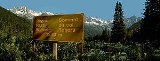
, camping, hiking and mountain climbing ever since the region became accessible in 1886. The location has tourist services including the Rogers Pass Discovery Centre, a hotel and National Park services. Rogers Pass is commemorated as a Canadian national historic site.
to the west and by the Beaver River to the east. Both of these rivers are tributaries of the Columbia River, which loops about 240 km around to the north of the pass. It was named after Major Rogers who first surveyed the pass.
Rogers Pass is known for its winter snowfall, which amounts to about 10 m per year. Because of steep mountains, avalanches are very common in winter. When the railway first went over the pass, 31 snow shed
s with a total length of about 6.5 km were built to protect the railway from the avalanches. Snow sheds for the Trans-Canada Highway
were built later, including large ones in 1962. To keep the Highway open during the winter, the Royal Canadian Artillery uses 105 mm howitzers to knock down the avalanches under controlled circumstances so traffic is not caught in unexpected avalanches.
was the northerly Yellowhead Pass
. When the railway construction project was turned over to a private company in 1881, the route was changed to the Kicking Horse Pass
. While the railway was being built across the prairies, the railway company had to find a pass over the unexplored Selkirk Mountains, or else it would have to detour around them via the Big Bend.
Major A. B. Rogers was hired in April 1881 by the railway company to find the pass with the promise of having the pass named after him and a $5000 bonus. Walter Moberly
had discovered Eagle Pass just to the west, and based on suggestions in Moberly's reports, Rogers started out from what is now Revelstoke, up the Illecillewaet River. Running out of food, Rogers and his party almost reached the summit but turned back feeling reasonably confident that a pass existed. Rogers returned the following year, 1882, from the east and reached a point where he could see where he had stopped the previous season, confirming that the pass existed and was good enough for the railway rapidly approaching across the prairies. Rogers was reluctant to cash the $5000 cheque, and instead framed it for his wall until CPR General Manager William Cornelius Van Horne
offered him a gold watch as an incentive to cash it.
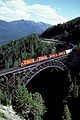 When the railway was built through the pass in 1884, the eastern approach up the Beaver River required some of the largest bridges on the line, including the often-photographed Stoney Creek Bridge
. A series of loops
were used on the west side of the pass to deal with the steep hill and avoid the avalanche
routes. After the Canadian Pacific Railway was completed in the fall of 1885, the railway was shutdown for the winter to observe the avalanches. In response, 31 snow sheds were built, with a total length of about 6.5 km.
Some major avalanches that came without warning caused the railway serious loss of life and property. In 1899, 8 people were killed when an avalanche destroyed the train station at the pass. On March 4, 1910
, the CPR suffered its worst loss. A crew and rotary snowplow were working to clear a snow slide when a second slide from the opposite side of the valley came down, killing 62 men. To avoid the avalanches the 8 km (5 mi) Connaught Tunnel
was completed under Rogers Pass in 1916. At the time, this was the longest railway tunnel in North America. Some sections of the abandoned railway eventually became walking rail trail
s in Glacier National Park.
Even with the tunnel, some of the CPR's largest locomotives and long helper districts
(pushers) were used to get trains up and over the pass. The Selkirk
steam locomotive, one of the biggest, was named after the mountain range penetrated by this pass. In 1988, the Canadian Pacific Railway opened the 14.7 km (9.1 mi) Mount Macdonald Tunnel
under the Pass to increase capacity (operating one tunnel in each direction) and to decrease the grades on the approach from the east.
. This also allowed the construction of Mica Dam
, which flooded part of the Big Bend as Kinbasket Lake
.
A number of snow sheds and earth dams are used to protect the Rogers Pass highway from avalanches. Rogers Pass is home to the largest mobile avalanche control program in the world. Parks Canada and the Department of National Defence
work together to keep the pass safe for traffic on the Trans-Canada Highway and the Canadian Pacific Railway mainline.
Mountain pass
A mountain pass is a route through a mountain range or over a ridge. If following the lowest possible route, a pass is locally the highest point on that route...
through the Selkirk Mountains
Selkirk Mountains
The Selkirk Mountains are a mountain range spanning the northern portion of the Idaho Panhandle, eastern Washington, and southeastern British Columbia. They begin at Mica Peak near Coeur d'Alene, Idaho and extend approximately 320 km north from the border. The range is bounded on its west,...
of British Columbia
British Columbia
British Columbia is the westernmost of Canada's provinces and is known for its natural beauty, as reflected in its Latin motto, Splendor sine occasu . Its name was chosen by Queen Victoria in 1858...
used by the Canadian Pacific Railway
Canadian Pacific Railway
The Canadian Pacific Railway , formerly also known as CP Rail between 1968 and 1996, is a historic Canadian Class I railway founded in 1881 and now operated by Canadian Pacific Railway Limited, which began operations as legal owner in a corporate restructuring in 2001...
and the Trans-Canada Highway
Trans-Canada Highway
The Trans-Canada Highway is a federal-provincial highway system that joins the ten provinces of Canada. It is, along with the Trans-Siberian Highway and Australia's Highway 1, one of the world's longest national highways, with the main route spanning 8,030 km...
. The pass is a shortcut across the "Big Bend" of the Columbia River
Columbia River
The Columbia River is the largest river in the Pacific Northwest region of North America. The river rises in the Rocky Mountains of British Columbia, Canada, flows northwest and then south into the U.S. state of Washington, then turns west to form most of the border between Washington and the state...
from Revelstoke
Revelstoke, British Columbia
Revelstoke is a city in southeastern British Columbia, Canada. It is located east of Vancouver, and west of Calgary, Alberta. The city is situated on the banks of the Columbia River just south of the Revelstoke Dam and near its confluence with the Illecillewaet River...
on the west to Donald
Donald, British Columbia
Donald, British Columbia is located on Highway 1, 28 kilometers west of Golden. In its heyday, Donald was a divisional point on the Canadian Pacific Railway...
, near Golden
Golden, British Columbia
Golden is a town in southeastern British Columbia, Canada, located west of Calgary, Alberta and east of Vancouver.-History:Much of the town's history is tied into the Canadian Pacific Railway and the logging industry...
, on the east. The pass was discovered on May 29, 1881, by Major Albert Bowman Rogers, a surveyor working for the Canadian Pacific Railway.
Rogers Pass is in the heart of Glacier National Park
Glacier National Park (Canada)
Glacier National Park is one of seven national parks in British Columbia, and is part of a system of 43 parks and park reserves across Canada. It protects a portion of the Columbia Mountains. It also contains the Rogers Pass National Historic Site, designated for its importance in the construction...
, in the midst of mountains popular for ski mountaineering
Ski mountaineering
Ski mountaineering is form of ski touring that variously combines the sports of Telemark, Alpine, and backcountry skiing with that of mountaineering...
, camping, hiking and mountain climbing ever since the region became accessible in 1886. The location has tourist services including the Rogers Pass Discovery Centre, a hotel and National Park services. Rogers Pass is commemorated as a Canadian national historic site.
Geography
Rogers Pass is a narrow valley surrounded by a number of mountains. It is formed by the headwaters of the Illecillewaet RiverIllecillewaet River
The Illecillewaet River is a tributary of the Columbia River located in British Columbia, Canada. Fed by the Illecillewaet Glacier in Glacier National Park, the river flows approximately to the southwest, where it flows into the north end of Upper Arrow Lake at Revelstoke...
to the west and by the Beaver River to the east. Both of these rivers are tributaries of the Columbia River, which loops about 240 km around to the north of the pass. It was named after Major Rogers who first surveyed the pass.
Rogers Pass is known for its winter snowfall, which amounts to about 10 m per year. Because of steep mountains, avalanches are very common in winter. When the railway first went over the pass, 31 snow shed
Snow shed
An avalanche snow bridge or simply snow bridge is a type of rigid snow-supporting structure for avalanche control . Avalanche bridges can be made of steel, prestressed concrete frames, or timber....
s with a total length of about 6.5 km were built to protect the railway from the avalanches. Snow sheds for the Trans-Canada Highway
Trans-Canada Highway
The Trans-Canada Highway is a federal-provincial highway system that joins the ten provinces of Canada. It is, along with the Trans-Siberian Highway and Australia's Highway 1, one of the world's longest national highways, with the main route spanning 8,030 km...
were built later, including large ones in 1962. To keep the Highway open during the winter, the Royal Canadian Artillery uses 105 mm howitzers to knock down the avalanches under controlled circumstances so traffic is not caught in unexpected avalanches.
Discovery
During the 1870s when the Canadian Pacific Railway was being planned, the preferred route through the Rocky MountainsRocky Mountains
The Rocky Mountains are a major mountain range in western North America. The Rocky Mountains stretch more than from the northernmost part of British Columbia, in western Canada, to New Mexico, in the southwestern United States...
was the northerly Yellowhead Pass
Yellowhead Pass
The Yellowhead Pass is a mountain pass across the Continental Divide of the Canadian Rockies. It is located on the border between the Canadian provinces of Alberta and British Columbia, and lies within Jasper National Park and Mount Robson Provincial Park....
. When the railway construction project was turned over to a private company in 1881, the route was changed to the Kicking Horse Pass
Kicking Horse Pass
Kicking Horse Pass is a high mountain pass across the Continental Divide of the Americas of the Canadian Rockies on the Alberta/British Columbia border, and lying within Yoho and Banff National Parks...
. While the railway was being built across the prairies, the railway company had to find a pass over the unexplored Selkirk Mountains, or else it would have to detour around them via the Big Bend.
Major A. B. Rogers was hired in April 1881 by the railway company to find the pass with the promise of having the pass named after him and a $5000 bonus. Walter Moberly
Walter Moberly (engineer)
Walter Moberly was a civil engineer and surveyor who played a large role in the early exploration and development of British Columbia, Canada, including discovering Eagle Pass, now used by the Canadian Pacific Railway and the Trans-Canada Highway.He was born in Steeple Aston, Oxfordshire, England...
had discovered Eagle Pass just to the west, and based on suggestions in Moberly's reports, Rogers started out from what is now Revelstoke, up the Illecillewaet River. Running out of food, Rogers and his party almost reached the summit but turned back feeling reasonably confident that a pass existed. Rogers returned the following year, 1882, from the east and reached a point where he could see where he had stopped the previous season, confirming that the pass existed and was good enough for the railway rapidly approaching across the prairies. Rogers was reluctant to cash the $5000 cheque, and instead framed it for his wall until CPR General Manager William Cornelius Van Horne
William Cornelius Van Horne
Sir William Cornelius Van Horne, KCMG was a pioneering Canadian railway executive.-Life and career:Born in 1843 in rural Illinois, he moved with his family to Joliet, Illinois when he was eight years old...
offered him a gold watch as an incentive to cash it.
Canadian Pacific Railway
Stoney Creek Bridge
Stoney Creek Bridge is a long truss arch bridge in British Columbia, Canada. It carries the Canadian Pacific Railway tracks over the Stoney Creek, between Revelstoke and Golden. A wooden bridge was originally built on the site in 1885, and the current steel structure was built in 1893. A second...
. A series of loops
Spiral (railway)
A spiral is a technique employed by railways to ascend steep hills.A railway spiral rises on a steady curve until it has completed a loop, passing over itself as it gains height, allowing the railway to gain vertical elevation in a relatively short horizontal distance...
were used on the west side of the pass to deal with the steep hill and avoid the avalanche
Avalanche
An avalanche is a sudden rapid flow of snow down a slope, occurring when either natural triggers or human activity causes a critical escalating transition from the slow equilibrium evolution of the snow pack. Typically occurring in mountainous terrain, an avalanche can mix air and water with the...
routes. After the Canadian Pacific Railway was completed in the fall of 1885, the railway was shutdown for the winter to observe the avalanches. In response, 31 snow sheds were built, with a total length of about 6.5 km.
Some major avalanches that came without warning caused the railway serious loss of life and property. In 1899, 8 people were killed when an avalanche destroyed the train station at the pass. On March 4, 1910
March 1910
January - February - March - April - May - June - July - August - September - October - November -DecemberThe following events occurred in March, 1910:-March 1, 1910 :...
, the CPR suffered its worst loss. A crew and rotary snowplow were working to clear a snow slide when a second slide from the opposite side of the valley came down, killing 62 men. To avoid the avalanches the 8 km (5 mi) Connaught Tunnel
Connaught Tunnel
Connaught Tunnel, in the Selkirk Mountains under Rogers Pass on the Canadian Pacific Railway main line between Calgary, Alberta, and Revelstoke, British Columbia, at long was, at the time it was built, the longest railway tunnel in North America. Dug under Mount Macdonald to ease growing traffic...
was completed under Rogers Pass in 1916. At the time, this was the longest railway tunnel in North America. Some sections of the abandoned railway eventually became walking rail trail
Rail trail
A rail trail is the conversion of a disused railway easement into a multi-use path, typically for walking, cycling and sometimes horse riding. The characteristics of former tracks—flat, long, frequently running through historical areas—are appealing for various development. The term sometimes also...
s in Glacier National Park.
Even with the tunnel, some of the CPR's largest locomotives and long helper districts
Bank engine
A bank engine or helper engine or pusher engine is a railway locomotive that temporarily assists a train that requires additional power or traction to climb a grade...
(pushers) were used to get trains up and over the pass. The Selkirk
Selkirk locomotive
The Selkirk locomotives were 36 steam locomotives of the 2-10-4 wheel arrangement built for Canadian Pacific Railway by Montreal Locomotive Works, Montreal, Quebec, Canada....
steam locomotive, one of the biggest, was named after the mountain range penetrated by this pass. In 1988, the Canadian Pacific Railway opened the 14.7 km (9.1 mi) Mount Macdonald Tunnel
Mount Macdonald Tunnel
The Mount Macdonald Tunnel, located in the vicinity of Rogers Pass in the Selkirk Mountains of British Columbia, Canada, is a railway tunnel constructed through Mount Macdonald by the Canadian Pacific Railway ....
under the Pass to increase capacity (operating one tunnel in each direction) and to decrease the grades on the approach from the east.
Trans-Canada Highway
The original highway between Revelstoke and Golden followed the Columbia River around the Big Bend to avoid crossing Rogers Pass. Between 1956 and 1962 a new highway was built over the pass to shorten the route, which now formed part of the Trans-Canada HighwayTrans-Canada Highway
The Trans-Canada Highway is a federal-provincial highway system that joins the ten provinces of Canada. It is, along with the Trans-Siberian Highway and Australia's Highway 1, one of the world's longest national highways, with the main route spanning 8,030 km...
. This also allowed the construction of Mica Dam
Mica Dam
The Mica Dam is a hydroelectric dam spanning the Columbia River 135 kilometres north of Revelstoke, British Columbia, Canada. Completed in 1973 under the terms of the 1964 Columbia River Treaty, the Mica powerhouse has a generating capacity of . The dam is operated by BC Hydro...
, which flooded part of the Big Bend as Kinbasket Lake
Kinbasket Lake
Kinbasket Lake is a reservoir on the Columbia River in southeast British Columbia, north of the city of Revelstoke and the town of Golden. The reservoir was created by the construction of the Mica Dam. The lake includes two reaches, Columbia Reach and Canoe Reach , referring to the river valleys...
.
A number of snow sheds and earth dams are used to protect the Rogers Pass highway from avalanches. Rogers Pass is home to the largest mobile avalanche control program in the world. Parks Canada and the Department of National Defence
Department of National Defence (Canada)
The Department of National Defence , frequently referred to by its acronym DND, is the department within the government of Canada with responsibility for all matters concerning the defence of Canada...
work together to keep the pass safe for traffic on the Trans-Canada Highway and the Canadian Pacific Railway mainline.
See also
- Canadian RockiesCanadian RockiesThe Canadian Rockies comprise the Canadian segment of the North American Rocky Mountains range. They are the eastern part of the Canadian Cordillera, extending from the Interior Plains of Alberta to the Rocky Mountain Trench of British Columbia. The southern end borders Idaho and Montana of the USA...
- Other CPR grades in British Columbia: Field HillField HillField Hill is a steep portion of the mainline of the Canadian Pacific Railway located near Field, British Columbia. Field was created solely to accommodate the Canadian Pacific Railway's need for additional locomotives to be added to trains about to tackle both Field Hill, and the Big Hill. Here a...
, Big HillBig HillThe Big Hill on the Canadian Pacific Railway main line in British Columbia, Canada, was the most difficult piece of railway track on the Canadian Pacific Railway's route. It was situated in the rugged Canadian Rockies west of the Continental Divide and Kicking Horse Pass...
, Spiral Tunnels, Eagle Pass - A. B. RogersA. B. RogersAlbert Bowman Rogers , commonly known as Major A.B. Rogers, was an American surveyor now best remembered for his discovery of the Rogers Pass in British Columbia, Canada...