
Fraser Valley Regional District
Encyclopedia
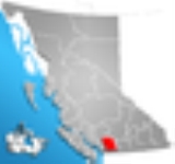
The Fraser Valley Regional District (FVRD) is a regional district in British Columbia
, Canada
. The FVRD covers an area of 13,361.74 km² (5,159 sq mi). It was created by an amalgamation of the Fraser-Cheam Regional District and Central Fraser Valley Regional District
and the portion of the Dewdney-Alouette Regional District
from and including the District of Mission eastwards.
The FVRD incorporates roughly the eastern half of the Lower Mainland
region of southwestern BC, and is bordered by Whatcom County, Washington
to the south, the Greater Vancouver Regional District
to the west, and the Okanagan-Similkameen Regional District
to the east. The northern border with the Squamish-Lillooet Regional District falls just south of the towns of Skookumchuck Hot Springs
and Lytton
. It also includes unincorporated areas north of the City of Pitt Meadows
which were formerly part of the Dewdney-Alouette Regional District but which were not transferred to the Greater Vancouver Regional District when it expanded to take in Pitt Meadows and Maple Ridge
.
.
(ALR). Retirement and recreational services (like campgrounds, RV parks, boating, skiing etc.) have become increasingly important. However, most commercial and industrial activities are kept within the municipal boundaries and leaving the electoral areas for farming and rural residential uses.
is a community on BC Highway 3 southeast of Hope with 164 people and was originally a Japanese internment camp named Tashme. Other communities in this area include Laidlaw
, west of Hope, and Spuzzum, north of Yale.
with 368 people, Harrison Mills
with 141 people, and the resort town of Hemlock Valley, with only 15 permanent residents but several hundred hotel guests and condo residents during the ski season). There are vacation homes on islands in Harrison Lake.
. Combined they have a population of 972 people.
Other residents of this area live on the north end of Cultus Lake
, or in the Columbia Valley
, south of Cultus Lake, bordering Washington state.
.
and contains mostly flat farm land. There are 149 people in the farming community of Deroche
; the area includes also Dewdney
, Nicomen Island
, and the small lakeside resort Lake Errock, and 534 people on Hatzic Island
, which lies in the midst of Hatzic Lake
, an oxbow lake
off the Hatzic Slough (an anabranch
of the Fraser River), just east of the boundaries of the District of Mission. Most of the population lives in low-density rural areas or on Indian reserves.
. Electoral area H was dissolved in 2008, with privately owned lands within the area being annexed into Abbotsford, and crown lands being reassigned to Electoral Area "G".
British Columbia
British Columbia is the westernmost of Canada's provinces and is known for its natural beauty, as reflected in its Latin motto, Splendor sine occasu . Its name was chosen by Queen Victoria in 1858...
, Canada
Canada
Canada is a North American country consisting of ten provinces and three territories. Located in the northern part of the continent, it extends from the Atlantic Ocean in the east to the Pacific Ocean in the west, and northward into the Arctic Ocean...
. The FVRD covers an area of 13,361.74 km² (5,159 sq mi). It was created by an amalgamation of the Fraser-Cheam Regional District and Central Fraser Valley Regional District
Central Fraser Valley Regional District
The Central Fraser Valley Regional District was a regional district in the province of British Columbia, Canada, located in the Lower Mainland region, south of the Fraser River and west of Chilliwack...
and the portion of the Dewdney-Alouette Regional District
Dewdney-Alouette Regional District
The Dewdney-Alouette Regional District was a regional district in the Lower Mainland of British Columbia, Canada, comprising the district municipalities of Pitt Meadows, Maple Ridge and Mission and uncincorporated areas east to the Harrison River and north to the southern end of Lillooet Lake...
from and including the District of Mission eastwards.
The FVRD incorporates roughly the eastern half of the Lower Mainland
Lower Mainland
The Lower Mainland is a name commonly applied to the region surrounding and including Vancouver, British Columbia, Canada. As of 2007, 2,524,113 people live in the region; sixteen of the province's thirty most populous municipalities are located there.While the term Lower Mainland has been...
region of southwestern BC, and is bordered by Whatcom County, Washington
Whatcom County, Washington
Whatcom County is a county located in the U.S. state of Washington. Its name ultimately derives from the Lummi word Xwotʼqom, meaning "noisy water." As of 2010, the population was 201,140. The county seat is at Bellingham, which is also the county's largest city...
to the south, the Greater Vancouver Regional District
Greater Vancouver Regional District
Metro Vancouver is the brand name of the board of the inter-municipal administrative body known as the Greater Vancouver Regional District , a regional district in British Columbia, Canada...
to the west, and the Okanagan-Similkameen Regional District
Regional District of Okanagan-Similkameen, British Columbia
The Regional District of Okanagan-Similkameen is a regional district in southern British Columbia, adjacent to the U.S. state of Washington...
to the east. The northern border with the Squamish-Lillooet Regional District falls just south of the towns of Skookumchuck Hot Springs
Skookumchuck Hot Springs, British Columbia
T'sek Hot Springs, near the First Nation community of Skookumchuck and more recently as Skatin is on the historic Harrison Lillooet Gold Rush trail in the Lillooet River valley, south of Lillooet Lake, in British Columbia, Canada...
and Lytton
Lytton, British Columbia
Lytton in British Columbia, Canada, sits at the confluence of the Thompson River and Fraser River on the east side of the Fraser. The location has been inhabited by the Nlaka'pamux people for over 10,000 years, and is one of the earliest locations settled by non-natives in the Southern Interior of...
. It also includes unincorporated areas north of the City of Pitt Meadows
Pitt Meadows, British Columbia
Pitt Meadows is a city in southwestern British Columbia, Canada and a member municipality in Metro Vancouver. Incorporated in 1914, it has a land area of 85.38 square kilometers and a population of 17,410 .-Geography:...
which were formerly part of the Dewdney-Alouette Regional District but which were not transferred to the Greater Vancouver Regional District when it expanded to take in Pitt Meadows and Maple Ridge
Maple Ridge, British Columbia
Maple Ridge is a District Municipality in British Columbia, located in the northeastern section of Metro Vancouver. Maple Ridge has a population of approximately 68,949.-History:...
.
Population
The FVRD has a total population of 257,031 people in 6 municipalities and 8 electoral areas. The following table breaks down each member municipality and electoral area according to population statistics from the 2006 Canadian censusCanada 2006 Census
The Canada 2006 Census was a detailed enumeration of the Canadian population. Census day was May 16, 2006. The next census following will be the 2011 Census. Canada's total population enumerated by the 2006 census was 31,612,897...
.
| Area | Population |
|---|---|
| City of Abbotsford Abbotsford, British Columbia Abbotsford is a Canadian city located in the Lower Mainland of British Columbia, adjacent to Greater Vancouver. It is the fifth largest municipality in British Columbia, home to 123,864 people . Its Census Metropolitan Area, which includes the District of Mission, is the 23rd largest in Canada,... |
123,864 |
| City of Chilliwack Chilliwack, British Columbia Chilliwack is a Canadian city in the Province of British Columbia. It is a predominantly agricultural community with an estimated population of 80,000 people. Chilliwack is the second largest city in the Fraser Valley Regional District after Abbotsford. The city is surrounded by mountains and... |
69,217 |
| District of Mission Mission, British Columbia Mission, the core of which was formerly known as Mission City, is a district municipality in the province of British Columbia, Canada. It is situated on the north bank of the Fraser River overlooking the City of Abbotsford and with that city is part of the Central Fraser Valley. Mission is the... |
34,505 |
| District of Hope Hope, British Columbia Hope is a district municipality located at the confluence of the Fraser and Coquihalla rivers in the province of British Columbia, Canada. Hope is at the eastern end of both the Fraser Valley and the Lower Mainland region, and is at the southern end of the Fraser Canyon... |
6,185 |
| District of Kent Kent, British Columbia The District of Kent is a district municipality located east of Vancouver, British Columbia. Part of the Fraser Valley Regional District, Kent consists of several communities, the largest and most well-known being Agassiz, the only town in the municipality, Harrison Mills, Kilby, Mount Woodside,... |
4,738 |
| Village of Harrison Hot Springs Harrison Hot Springs, British Columbia The Village of Harrison Hot Springs is a small community at the southern end of Harrison Lake in the Fraser Valley of British Columbia. It is a member of the Fraser Valley Regional District; its immediate neighbour is the District of Kent and included in it, the town of Agassiz. It is a resort... |
1,573 |
| Electoral Area "A" | 478 |
| Electoral Area "B" | 796 |
| Electoral Area "C" | 952 |
| Electoral Area "D" | 1,296 |
| Electoral Area "E" | 3,481 |
| Electoral Area "F" | 1,339 |
| Electoral Area "G" | 1,914 |
| Electoral Area "H" | 394 |
Services
While the member municipalities provide for their own municipal services the FVRD acts as the local government for the electoral areas. As a local government or regional district it can provide such services as water piping, storm sewers, sanitary sewers, street lighting, waste management, fire protection, mosquito control, E911 service, emergency preparedness/recovery, cablevision, air quality monitoring, library funding, growth management, park maintenance, building inspections and bylaw enforcement, planning, development approvals etc. Each area does not necessarily receive all these services so each electoral area pays property taxes, through the provincial government, in accordance with the particular services they receive. The FVRD has opted to implement a regional growth strategy, as allowed by Section 25 of the BC Local Government Act.Political structure
The regional district is a federation of municipalities and electoral areas. Each municipality appoints councillors to the board of directors for the regional district in proportion to their relative population sizes and the electoral areas directly elect one director each.Economy
Economically, the area has grown around resource extraction, specifically farming, logging and gravel mining. Much of the Fraser Valley's land base is located within the Agricultural Land ReserveAgricultural Land Reserve
The Agricultural Land Reserve is a collection of land in the Canadian province of British Columbia in which agriculture is recognized as the priority use. Farming is encouraged and non-agricultural uses are controlled. In total, the ALR covers approximately and includes private and public lands...
(ALR). Retirement and recreational services (like campgrounds, RV parks, boating, skiing etc.) have become increasingly important. However, most commercial and industrial activities are kept within the municipal boundaries and leaving the electoral areas for farming and rural residential uses.
Electoral area, geography, and climate
The areas in a regional district that are not incorporated are called ‘electoral areas’.Electoral area "A"
Boston Bar and North Bend, with populations nearing 200 people each, are the two main small towns in this area. Other residents of this area live in small subdivisions (i.e. Canyon Alpine and Falls Creek) or Indian reserves which line the Fraser Canyon.Electoral area "B"
Communities in this area are connected by three highways (Highway #1, #3, #5) which radiate out of the District of Hope. The communities of Dogwood Valley, Emory Creek, and Choate are just north of Hope and have a combined population of about 133 people. Sunshine ValleySunshine Valley, British Columbia
Sunshine Valley, formerly named Tashme, is an unincorporated settlement and former Japanese Canadian internment camp on the Crowsnest Highway between of the town of Hope and the entrance to Manning Park in the Cascade Mountains of British Columbia...
is a community on BC Highway 3 southeast of Hope with 164 people and was originally a Japanese internment camp named Tashme. Other communities in this area include Laidlaw
Laidlaw, British Columbia
Laidlaw is an unincorporated settlement in the Upper Fraser Valley region of British Columbia, Canada, located just west of the westernmost boundary of Hope, British Columbia on the south side of the Fraser River and along the Trans-Canada Highway....
, west of Hope, and Spuzzum, north of Yale.
Electoral area "C"
Communities in this area include Lake ErrockLake Errock
Lake Errock is an unincorporated settlement on the northwest shore of the lake of the same name, which is located in the Upper Fraser Valley region of the Lower Mainland of British Columbia, Canada. It lies alongside BC Highway 7 and the tracks of the Canadian Pacific Railway between Deroche and...
with 368 people, Harrison Mills
Harrison Mills
Harrison Mills, formerly Carnarvon and also Harrison River, is an agricultural farming and tourism-based community in the District of Kent west of Agassiz, British Columbia. The community is a part of the Fraser Valley Regional District...
with 141 people, and the resort town of Hemlock Valley, with only 15 permanent residents but several hundred hotel guests and condo residents during the ski season). There are vacation homes on islands in Harrison Lake.
Electoral area "D"
The population of this area lives in the unincorporated villages of Popkum and Bridal FallsBridal Falls, British Columbia
Bridal Falls is a community in the Fraser Valley of British Columbia, located east of Rosedale and immediately adjacent to the on-ramps for the Agassiz-Rosedale Bridge, which connects the Trans-Canada Highway at Bridal Falls to Agassiz, on BC Highway 7. Bridal Falls is mostly a highway services...
. Combined they have a population of 972 people.
Electoral area "E"
The Chilliwack River runs east-west through this area. Most of the population live in the small area between the mountains and the river, which is generally divided into three areas: Slesse Park, Baker Trails and Bell Acres.Other residents of this area live on the north end of Cultus Lake
Cultus Lake, British Columbia
Cultus Lake Park is a lake, associated community and provincial park in the Fraser Valley region of British Columbia, Canada. It is the source of the Sweltzer River. The lake itself is warm, and the area has become a popular recreation destination with ample opportunities for fishing, water...
, or in the Columbia Valley
Columbia Valley
The Columbia Valley is the name used for a region in the Rocky Mountain Trench near the headwaters of the Columbia River between the town of Golden and the Canal Flats. The main hub of the valley is the town of Invermere. Other towns include Radium Hot Springs, Windermere and Fairmont Hot Springs...
, south of Cultus Lake, bordering Washington state.
Electoral area "F"
The population here lives exclusively in the southern, lowland portion of this electoral area between Hatzic Lake the southeast end of Stave Lake, as everything north of Stave Lake is inaccessible or uninhabitable. The inhabited area can be broken into two sections: Miracle Valley, including an area known as McConnell Creek, and Hatzic Prairie, which includes the farming town of DurieuDurieu, British Columbia
Durieu is a farming community, located on Hatzic Prairie northeast of Mission, British Columbia, Canada in the Fraser Valley region of that province's Lower Mainland. Also known locally as Hatzic Prairie, it has few services other than a store, feed co-op, school and community hall.The community...
.
Electoral area "G"
This small but populous electoral area is just north of the Fraser RiverFraser River
The Fraser River is the longest river within British Columbia, Canada, rising at Fraser Pass near Mount Robson in the Rocky Mountains and flowing for , into the Strait of Georgia at the city of Vancouver. It is the tenth longest river in Canada...
and contains mostly flat farm land. There are 149 people in the farming community of Deroche
Deroche, British Columbia
Deroche is a farming and railway community on the Canadian Pacific Railway and BC Highway 7 located approximately 110 km east of Vancouver, British Columbia, Canada. Deroche is adjacent to the eastern end of Nicomen Island, from which it is separated by the Nicomen Slough...
; the area includes also Dewdney
Dewdney, British Columbia
Dewdney is an unincorporated community in the Central Fraser Valley of British Columbia, Canada, about 15 km east of the town of Mission. It was incorporated as a district municipality in 1893 but has since become unincorporated and is now represented as part of Electoral Area 'G' in the...
, Nicomen Island
Nicomen Island
Nicomen Island is an island in the Fraser River east of Mission and between Deroche and Dewdney . Located on the river's north side, and separated from the foot of the Douglas Ranges by Nicomen Slough, the island is near-totally given over to agriculture and constitutes a rural community in its...
, and the small lakeside resort Lake Errock, and 534 people on Hatzic Island
Hatzic Island
Hatzic Island is an island located in the centre of Hatzic Lake, an oxbow lake formation adjoining the Fraser River just east of Mission, British Columbia, Canada...
, which lies in the midst of Hatzic Lake
Hatzic Lake
Hatzic Lake is an oxbow lake adjoining the Fraser River on the east side of Mission, British Columbia, Canada, immediately below that district municipality's neighbourhood of Hatzic, which is on a benchland above and to the west of the lake...
, an oxbow lake
Oxbow lake
An oxbow lake is a U-shaped body of water formed when a wide meander from the main stem of a river is cut off to create a lake. This landform is called an oxbow lake for the distinctive curved shape, named after part of a yoke for oxen. In Australia, an oxbow lake is called a billabong, derived...
off the Hatzic Slough (an anabranch
Anabranch
An anabranch is a section of a river or stream that diverts from the main channel or stem of the watercourse and rejoins the main stem downstream. Local anabranches can be the result of small islands in the watercourse...
of the Fraser River), just east of the boundaries of the District of Mission. Most of the population lives in low-density rural areas or on Indian reserves.
Electoral area "H"
This area consisted of the majority of Sumas MountainSumas Mountain (British Columbia)
Sumas Mountain, aka referred to as Canadian Sumas to distinguish it from an identically-named mountain just south in Washington state, is a relatively large mountain rising from the floodplain of the Fraser River in the Lower Mainland of southwestern British Columbia, Canada...
. Electoral area H was dissolved in 2008, with privately owned lands within the area being annexed into Abbotsford, and crown lands being reassigned to Electoral Area "G".