

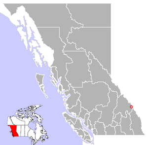
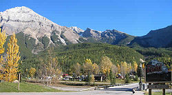
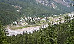
Field, British Columbia
Encyclopedia
Kicking Horse River
The Kicking Horse River is a river located in the Canadian Rockies of southeastern British Columbia, Canada.The river was named in 1858, when James Hector, a member of the Palliser Expedition, was kicked by his packhorse while exploring the river. Hector survived and named the river and the...
valley of southeastern British Columbia
British Columbia
British Columbia is the westernmost of Canada's provinces and is known for its natural beauty, as reflected in its Latin motto, Splendor sine occasu . Its name was chosen by Queen Victoria in 1858...
,
Canada
Canada
Canada is a North American country consisting of ten provinces and three territories. Located in the northern part of the continent, it extends from the Atlantic Ocean in the east to the Pacific Ocean in the west, and northward into the Arctic Ocean...
, within the confines of Yoho National Park
Yoho National Park
Yoho National Park is located in the Canadian Rocky Mountains along the western slope of the Continental Divide in southeastern British Columbia. Yoho NP is bordered by Kootenay National Park on the southern side and Banff National Park on the eastern side...
.
Field was established during the building of the Canadian Pacific Railway
Canadian Pacific Railway
The Canadian Pacific Railway , formerly also known as CP Rail between 1968 and 1996, is a historic Canadian Class I railway founded in 1881 and now operated by Canadian Pacific Railway Limited, which began operations as legal owner in a corporate restructuring in 2001...
(CPR) as a locomotive depot for pusher engines required to help trains over the nearby Field Hill
Field Hill
Field Hill is a steep portion of the mainline of the Canadian Pacific Railway located near Field, British Columbia. Field was created solely to accommodate the Canadian Pacific Railway's need for additional locomotives to be added to trains about to tackle both Field Hill, and the Big Hill. Here a...
and Big Hill
Big Hill
The Big Hill on the Canadian Pacific Railway main line in British Columbia, Canada, was the most difficult piece of railway track on the Canadian Pacific Railway's route. It was situated in the rugged Canadian Rockies west of the Continental Divide and Kicking Horse Pass...
. The town was given its name by the CPR in December 1884 to honour American businessman Cyrus West Field
Cyrus West Field
Cyrus West Field was an American businessman and financier who, along with other entrepreneurs, created the Atlantic Telegraph Company and laid the first telegraph cable across the Atlantic Ocean in 1858.-Life and career:...
, who was instrumental in establishing trans-atlantic telegraph service.
Field is 27 km (16.8 mi) west of Lake Louise
Lake Louise, Alberta
Lake Louise is a hamlet in Alberta, Canada within Improvement District No. 9 Banff . It is named for the nearby Lake Louise, which in turn was named after the Princess Louise Caroline Alberta , the fourth daughter of Queen Victoria, and the wife of John Campbell, the 9th Duke of Argyll, who was the...
along the Trans-Canada Highway
Trans-Canada Highway
The Trans-Canada Highway is a federal-provincial highway system that joins the ten provinces of Canada. It is, along with the Trans-Siberian Highway and Australia's Highway 1, one of the world's longest national highways, with the main route spanning 8,030 km...
which provides the only road access to the town.
Field hosts the Yoho National Park
Yoho National Park
Yoho National Park is located in the Canadian Rocky Mountains along the western slope of the Continental Divide in southeastern British Columbia. Yoho NP is bordered by Kootenay National Park on the southern side and Banff National Park on the eastern side...
visitor centre; those wishing to visit the nearby area surrounding Lake O'Hara
Lake o'hara
Lake O'Hara a lake at an elevation of 2,115 m in the alpine area of Yoho National Park, in the province of British Columbia, on the western side of the Great Divide with the province of Alberta and Banff National Park to the east...
must either obtain tickets for a bus service managed by Yoho National Park or hike the 11 kilometres (6.8 mi) dirt road on foot. Due to the extreme popularity of the Lake O'Hara region, bus reservations often sell out 3 months in advance.
There are many hiking
Hiking
Hiking is an outdoor activity which consists of walking in natural environments, often in mountainous or other scenic terrain. People often hike on hiking trails. It is such a popular activity that there are numerous hiking organizations worldwide. The health benefits of different types of hiking...
opportunities near the town including:
- Burgess Pass - 6.6 km (4.1 mi) one way, provides views of Emerald Lake and the Wapta Icefields.
- Emerald Lake - 11 km (7 mi) from Field on a paved road. A 5 km (3 mi) lakeshore trail circles the entire lake.
- Sherbrooke LakeSherbrooke Lake (British Columbia)Sherbrooke Lake is a lake in Yoho National Park, British Columbia, Canada. The lake is bounded on the west by Mount Ogden , Mount Niles to the north, and Paget Peak on the east side...
- 3.1 km (1.9 mi) one way - Twin Falls - 9th highest waterfallWaterfallA waterfall is a place where flowing water rapidly drops in elevation as it flows over a steep region or a cliff.-Formation:Waterfalls are commonly formed when a river is young. At these times the channel is often narrow and deep. When the river courses over resistant bedrock, erosion happens...
in Canada - Wapta Falls - a short 2.4 km (1.5 mi) round trip trail to the waterfall that produces the largest volume of water in Yoho NP.
Scrambling
Scrambling
Scrambling is a method of ascending rocky faces and ridges. It is an ambiguous term that lies somewhere between hillwalking and rock climbing. It is often distinguished from hillwalking by defining a scramble as a route where hands must be used in the ascent...
options include: Mount Burgess
Mount Burgess
Mount Burgess, , is a mountain in Yoho National Park and is part of the Canadian Rockies. It is located in the southwest buttress of Burgess Pass in the Emerald River and Kicking Horse River Valleys.-History:...
(2599 m or 8,526.9 ft), Mount Field
Mount Field (British Columbia)
Mount Field is a mountain located about east of the town of Field in Yoho National Park, Canada. The mountain was named in 1883 after Cyrus West Field, a guest of the CPR who were building the national railway....
(2635 m or 8,645 ft), Mount Stephen
Mount Stephen
Mount Stephen is a mountain located in the Kicking Horse River Valley of Yoho National Park, ½ km east of Field. The mountain was named in 1886 for George Stephen, the first president of the Canadian Pacific Railway....
(3199 m or 10,495.4 ft) and Paget Peak (2560 m or 8,399 ft).
There are several points of interests nearby including:
- Takakkaw FallsTakakkaw FallsTakakkaw Falls is a waterfall located in Yoho National Park, near Field, British Columbia, in Canada. Its highest point is 384m from its base, making it the second-highest officially measured waterfall in western Canada, after Della Falls on Vancouver Island...
— second highest waterfall in Canada - Burgess shaleBurgess ShaleThe Burgess Shale Formation, located in the Canadian Rockies of British Columbia, is one of the world's most celebrated fossil fields, and the best of its kind. It is famous for the exceptional preservation of the soft parts of its fossils...
— fossil beds (restricted access) - Natural BridgeNatural archA natural arch or natural bridge is a natural geological formation where a rock arch forms, with an opening underneath. Most natural arches form as a narrow ridge, walled by cliffs, become narrower from erosion, with a softer rock stratum under the cliff-forming stratum gradually eroding out until...
— Kicking Horse RiverKicking Horse RiverThe Kicking Horse River is a river located in the Canadian Rockies of southeastern British Columbia, Canada.The river was named in 1858, when James Hector, a member of the Palliser Expedition, was kicked by his packhorse while exploring the river. Hector survived and named the river and the...
has carved a natural bridge through solid rock. - Spiral Tunnels Exhibit — Explains railway tunnels bored through Mount Ogden (lower Spiral Tunnel) and Cathedral Mountain (upper Spiral Tunnel).
- Emerald Lake (British Columbia) — largest lake in Yoho National ParkYoho National ParkYoho National Park is located in the Canadian Rocky Mountains along the western slope of the Continental Divide in southeastern British Columbia. Yoho NP is bordered by Kootenay National Park on the southern side and Banff National Park on the eastern side...
External links
- Field.ca - Information for people traveling to Field and Yoho National Park
- Friends of Yoho - The Friends of Yoho National Park Society promote appreciation, understanding and stewardship of the ecology and culture of Yoho National Park
- BC Archives Photo: Mount Stephen Hotel and CPR Station in Field, 1905