
Yoho National Park
Encyclopedia
Yoho National Park is located in the Canadian
Rocky Mountains
along the western slope of the Continental Divide
in southeastern British Columbia
. Yoho NP is bordered by Kootenay National Park
on the southern side and Banff National Park
on the eastern side. The name Yoho comes from a Cree
word expressing amazement.
Yoho covers 1,313 km² (507 mi²) and it is the smallest of the four contiguous national parks (NP). Yoho, together with Jasper NP
, Kootenay NP and Banff NP, along with three British Columbia provincial parks—Hamber Provincial Park
, Mount Assiniboine Provincial Park
, and Mount Robson Provincial Park
—form the Canadian Rocky Mountain Parks
World Heritage Site
. The park's administrative and visitor centre are located in the town of Field, British Columbia
, beside the Trans-Canada Highway
.
World Heritage Site
in 1984.
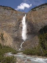
 The Kicking Horse River
, a Canadian Heritage river, originates in the Wapta and Waputik icefields in the park. This river has created a natural bridge through solid rock. This formation is located 3 km west of Field, accessible from the road to Emerald Lake.
The Canadian Rockies
consist of sedimentary rock
, with numerous fossil
deposits. In particular, the Burgess Shale
, located in Yoho National Park, has among the world's richest deposits of rare fossils. The Burgess Shale was discovered in 1909 by Charles Doolittle Walcott
. In the southeastern corner of the park is an igneous intrusion known as the Ice River Complex containing deposits of sodalite
, an ornamental stone.
Canada
Canada is a North American country consisting of ten provinces and three territories. Located in the northern part of the continent, it extends from the Atlantic Ocean in the east to the Pacific Ocean in the west, and northward into the Arctic Ocean...
Rocky Mountains
Rocky Mountains
The Rocky Mountains are a major mountain range in western North America. The Rocky Mountains stretch more than from the northernmost part of British Columbia, in western Canada, to New Mexico, in the southwestern United States...
along the western slope of the Continental Divide
Continental Divide
The Continental Divide of the Americas, or merely the Continental Gulf of Division or Great Divide, is the name given to the principal, and largely mountainous, hydrological divide of the Americas that separates the watersheds that drain into the Pacific Ocean from those river systems that drain...
in southeastern British Columbia
British Columbia
British Columbia is the westernmost of Canada's provinces and is known for its natural beauty, as reflected in its Latin motto, Splendor sine occasu . Its name was chosen by Queen Victoria in 1858...
. Yoho NP is bordered by Kootenay National Park
Kootenay National Park
Kootenay National Park is located in southeastern British Columbia Canada covering in the Canadian Rockies and forms part of a World Heritage Site. The park ranges in elevation from at the south-west park entrance to at Deltaform Mountain...
on the southern side and Banff National Park
Banff National Park
Banff National Park is Canada's oldest national park, established in 1885 in the Rocky Mountains. The park, located 110–180 kilometres west of Calgary in the province of Alberta, encompasses of mountainous terrain, with numerous glaciers and ice fields, dense coniferous forest, and alpine...
on the eastern side. The name Yoho comes from a Cree
Cree language
Cree is an Algonquian language spoken by approximately 117,000 people across Canada, from the Northwest Territories and Alberta to Labrador, making it the aboriginal language with the highest number of speakers in Canada. It is also spoken in the U.S. state of Montana...
word expressing amazement.
Yoho covers 1,313 km² (507 mi²) and it is the smallest of the four contiguous national parks (NP). Yoho, together with Jasper NP
Jasper National Park
Jasper National Park is the largest national park in the Canadian Rockies, spanning 10,878 km² . It is located in the province of Alberta, north of Banff National Park and west of the City of Edmonton. The park includes the glaciers of the Columbia Icefield, hot springs, lakes, waterfalls and...
, Kootenay NP and Banff NP, along with three British Columbia provincial parks—Hamber Provincial Park
Hamber Provincial Park
Hamber Provincial Park is a provincial park in British Columbia, Canada, located at the provincial border with Alberta, surrounded on three sides by Jasper National Park.-History:The park was named in honour of Eric W...
, Mount Assiniboine Provincial Park
Mount Assiniboine Provincial Park
Mount Assiniboine Provincial Park is a provincial park in British Columbia, Canada, located around Mount Assiniboine.-History:The park was established 1922...
, and Mount Robson Provincial Park
Mount Robson Provincial Park
Mount Robson Provincial Park is a large provincial park in the Canadian Rockies with an area of 2,249 km². The park is located entirely within British Columbia, bordering Jasper National Park in Alberta. The B.C. legislature created the park in 1913, the same year as the first ascent of Mount...
—form the Canadian Rocky Mountain Parks
Canadian Rocky Mountain Parks
The Canadian Rocky Mountain Parks World Heritage Site is located in the Canadian Rockies. It consists of four national parks:*Banff*Jasper*Kootenay*Yohoand three British Columbia provincial parks:*Hamber Provincial Park...
World Heritage Site
World Heritage Site
A UNESCO World Heritage Site is a place that is listed by the UNESCO as of special cultural or physical significance...
. The park's administrative and visitor centre are located in the town of Field, British Columbia
Field, British Columbia
Field is an unincorporated settlement of approximately 300 people located in the Kicking Horse River valley of southeastern British Columbia,Canada, within the confines of Yoho National Park....
, beside the Trans-Canada Highway
Trans-Canada Highway
The Trans-Canada Highway is a federal-provincial highway system that joins the ten provinces of Canada. It is, along with the Trans-Siberian Highway and Australia's Highway 1, one of the world's longest national highways, with the main route spanning 8,030 km...
.
History
The contiguous national parks of Banff, Jasper, Kootenay and Yoho, as well as the Mount Robson, Mount Assiniboine and Hamber provincial parks were declared a UNESCOUNESCO
The United Nations Educational, Scientific and Cultural Organization is a specialized agency of the United Nations...
World Heritage Site
World Heritage Site
A UNESCO World Heritage Site is a place that is listed by the UNESCO as of special cultural or physical significance...
in 1984.
Geology
Kicking Horse River
The Kicking Horse River is a river located in the Canadian Rockies of southeastern British Columbia, Canada.The river was named in 1858, when James Hector, a member of the Palliser Expedition, was kicked by his packhorse while exploring the river. Hector survived and named the river and the...
, a Canadian Heritage river, originates in the Wapta and Waputik icefields in the park. This river has created a natural bridge through solid rock. This formation is located 3 km west of Field, accessible from the road to Emerald Lake.
The Canadian Rockies
Canadian Rockies
The Canadian Rockies comprise the Canadian segment of the North American Rocky Mountains range. They are the eastern part of the Canadian Cordillera, extending from the Interior Plains of Alberta to the Rocky Mountain Trench of British Columbia. The southern end borders Idaho and Montana of the USA...
consist of sedimentary rock
Sedimentary rock
Sedimentary rock are types of rock that are formed by the deposition of material at the Earth's surface and within bodies of water. Sedimentation is the collective name for processes that cause mineral and/or organic particles to settle and accumulate or minerals to precipitate from a solution....
, with numerous fossil
Fossil
Fossils are the preserved remains or traces of animals , plants, and other organisms from the remote past...
deposits. In particular, the Burgess Shale
Burgess Shale
The Burgess Shale Formation, located in the Canadian Rockies of British Columbia, is one of the world's most celebrated fossil fields, and the best of its kind. It is famous for the exceptional preservation of the soft parts of its fossils...
, located in Yoho National Park, has among the world's richest deposits of rare fossils. The Burgess Shale was discovered in 1909 by Charles Doolittle Walcott
Charles Doolittle Walcott
Charles Doolittle Walcott was an American invertebrate paleontologist. He became known for his discovery in 1909 of well-preserved fossils in the Burgess Shale of British Columbia, Canada.-Early life:...
. In the southeastern corner of the park is an igneous intrusion known as the Ice River Complex containing deposits of sodalite
Sodalite
Sodalite is a rich royal blue mineral widely enjoyed as an ornamental gemstone. Although massive sodalite samples are opaque, crystals are usually transparent to translucent...
, an ornamental stone.
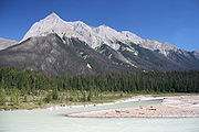
Mountains
- Mount BurgessMount BurgessMount Burgess, , is a mountain in Yoho National Park and is part of the Canadian Rockies. It is located in the southwest buttress of Burgess Pass in the Emerald River and Kicking Horse River Valleys.-History:...
2,999m (8,527 ft) is a frequently climbed mountain. For 17 years it was featured on the Canadian ten-dollar billCanadian ten-dollar billThe Canadian ten-dollar bill is one of the most common banknotes of the Canadian dollar. It was the first bill printed when Canada changed its banknotes in 2001....
. - Mount StephenMount StephenMount Stephen is a mountain located in the Kicking Horse River Valley of Yoho National Park, ½ km east of Field. The mountain was named in 1886 for George Stephen, the first president of the Canadian Pacific Railway....
3,889m (10,496 ft) is the tallest of the four mountains that surround the town of Field, British ColumbiaField, British ColumbiaField is an unincorporated settlement of approximately 300 people located in the Kicking Horse River valley of southeastern British Columbia,Canada, within the confines of Yoho National Park....
. A portion of the Burgess ShaleBurgess ShaleThe Burgess Shale Formation, located in the Canadian Rockies of British Columbia, is one of the world's most celebrated fossil fields, and the best of its kind. It is famous for the exceptional preservation of the soft parts of its fossils...
fossils were discovered on Mount Stephen. - The PresidentThe PresidentThe President is mountain peak on the The President/Vice-President Massif, just North of Emerald Lake in Yoho National Park, near the Alpine Club of Canada's Stanley Mitchell hut....
3,008m (10,296 ft) - The Vice PresidentThe Vice PresidentThe Vice-President is a mountain on the The President/Vice-President Massif just North of Emerald Lake in Yoho National Park, near the Alpine Club of Canada's Stanley Mitchell hut....
3,066m (10,060 ft) - Mount GoodsirMount GoodsirMount Goodsir is the highest mountain in the Ottertail Range, a subrange of the Canadian Rockies in British Columbia. It is located in Yoho National Park, near its border with Kootenay National Park...
3,897m (11,703 ft) - Mount Balfour 3,926m (10,735 ft.)
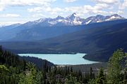
See also
- List of lakes in Yoho National Park
- Emerald Lake