
Cowichan Valley Regional District, British Columbia
Encyclopedia
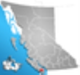
The Cowichan Valley Regional District is a regional district in the Canadian province of British Columbia
is on the southern part of Vancouver Island
, bordered by the Nanaimo
and Alberni-Clayoquot
Regional Districts to the north and northwest, and by the Capital Regional District
to the south and east. As of the 2006 Census
, the Regional District had a population of 76,929. The regional district offices are in Duncan
.
on the east coast of Vancouver Island and the southern part of the West Coast Trail
, with Cowichan Lake located in its central region. It includes the Gulf Islands
of Thetis
, Kuper
and Valdes
. The total land area is 3,473.12 km² (1,340.98 sq mi).
British Columbia
British Columbia is the westernmost of Canada's provinces and is known for its natural beauty, as reflected in its Latin motto, Splendor sine occasu . Its name was chosen by Queen Victoria in 1858...
is on the southern part of Vancouver Island
Vancouver Island
Vancouver Island is a large island in British Columbia, Canada. It is one of several North American locations named after George Vancouver, the British Royal Navy officer who explored the Pacific Northwest coast of North America between 1791 and 1794...
, bordered by the Nanaimo
Regional District of Nanaimo, British Columbia
The Regional District of Nanaimo is a regional district located on the eastern coast of Vancouver Island, British Columbia, Canada. It is bordered to the south by the Cowichan Valley Regional District, to the west by the Alberni-Clayoquot Regional District, and to the northwest by the Comox Valley...
and Alberni-Clayoquot
Alberni-Clayoquot Regional District, British Columbia
The Alberni-Clayoquot Regional District of British Columbia is located on west central Vancouver Island. Adjacent regional districts it shares borders with are the Strathcona and Comox Valley Regional Districts to the north, and the Nanaimo and Cowichan Valley Regional Districts to the east...
Regional Districts to the north and northwest, and by the Capital Regional District
Capital Regional District, British Columbia
The Capital Regional District is a local government administrative district encompassing the southern tip of Vancouver Island and the southern Gulf Islands in the Canadian province of British Columbia...
to the south and east. As of the 2006 Census
Canada 2006 Census
The Canada 2006 Census was a detailed enumeration of the Canadian population. Census day was May 16, 2006. The next census following will be the 2011 Census. Canada's total population enumerated by the 2006 census was 31,612,897...
, the Regional District had a population of 76,929. The regional district offices are in Duncan
Duncan, British Columbia
Duncan is a city on southern Vancouver Island in British Columbia, Canada.-History:The community is named after William Chalmers Duncan . He arrived in Victoria in May 1862, then in August of that year he was one of the party of a hundred settlers which Governor Douglas took to Cowichan Bay...
.
Geography
The Cowichan Valley Regional District covers an area between the Stuart Channel and Saanich InletSaanich Inlet
Saanich Inlet is a body of salt water that lies between the Saanich Peninsula and the Malahat highlands of Vancouver Island, British Columbia, Canada. Located just northwest of Victoria, the inlet is 24 km long , has a surface area of 65 km2 , and its maximum depth is 225 m . Great...
on the east coast of Vancouver Island and the southern part of the West Coast Trail
West Coast Trail
The West Coast Trail is a long backpacking trail following the southwestern edge of Vancouver Island in British Columbia, Canada. It was built in 1907 to facilitate the rescue of survivors of shipwrecks along the coast, part of the treacherous Graveyard of the Pacific...
, with Cowichan Lake located in its central region. It includes the Gulf Islands
Gulf Islands
The Gulf Islands are the islands in the Strait of Georgia , between Vancouver Island and the mainland of British Columbia, Canada....
of Thetis
Thetis Island
Thetis Island is an island off the coast of British Columbia, Canada. It is one of the Gulf Islands. The island was named in 1851 after HMS Thetis, a 36-gun Royal Navy frigate commanded by Captain Augustus Leopold Kuper . The ship was named after the Nereid Thetis from Greek mythology...
, Kuper
Kuper Island
Kuper Island belongs to the Penelakut First Nation and is located in the southern Gulf Islands between Vancouver Island and the mainland Pacific coast of British Columbia, Canada. Kuper has a population of about 300 members of the Penelakut Band. The island has an area of 8.66 km²...
and Valdes
Valdes Island
Valdes Island is one of the Gulf Islands located in the Strait of Georgia, British Columbia, Canada. It is across Porlier Pass from Galiano Island, which lies to the southeast. It has an area of 23 km2, and is 1.6 km wide by 16 km in length...
. The total land area is 3,473.12 km² (1,340.98 sq mi).
Incorporated communities
- DuncanDuncan, British ColumbiaDuncan is a city on southern Vancouver Island in British Columbia, Canada.-History:The community is named after William Chalmers Duncan . He arrived in Victoria in May 1862, then in August of that year he was one of the party of a hundred settlers which Governor Douglas took to Cowichan Bay...
- LadysmithLadysmith, British ColumbiaLadysmith is a town located on the 49th parallel on the east coast of Vancouver Island British Columbia, Canada. The local economy is based on forestry, tourism and agriculture. A hillside location adjacent to a sheltered harbour form the natural characteristics of the community., the population...
- Lake CowichanLake Cowichan, British ColumbiaCowichan Lake is a large freshwater lake located on southern Vancouver Island, British Columbia, Canada. It is located along the Cowichan Valley in the Cowichan Valley Regional District, with its eastern shore about west of Duncan, British Columbia. Cowichan Lake is about in length, running...
- North CowichanNorth Cowichan, British ColumbiaNorth Cowichan is a District municipality on Vancouver Island in British Columbia, Canada and is in the Cowichan Valley Regional District...
(Includes the communities of ChemainusChemainus, British ColumbiaChemainus is a community on the east coast of Vancouver Island, British Columbia, Canada.Founded as a logging town in 1858, the town is now famous for its 39 outdoor murals. This outdoor gallery has given birth to 300 businesses, including a theatre, antiques dealers, and eateries. The tourist...
, CroftonCrofton, British ColumbiaCrofton, British Columbia, Canada, is a small coastal town that is part of the District of North Cowichan on Vancouver Island in British Columbia. The population is estimated at 2,500 people...
and Maple BayMaple Bay, British ColumbiaMaple Bay is a picturesque seaside community located in the Cowichan Valley of southern Vancouver Island, British Columbia, Canada. A narrow inlet and surrounded by smooth, pebbled beaches, Maple Bay is home to marine activity all year round....
Native reserves
- Chemainus 13
- Claoose 4
- Cowichan 1Cowichan 1, British ColumbiaCowichan Indian Reserve No. 1 is an Indian Reserve in British Columbia, located south of the City of Duncan.-See also:*Cowichan Tribes...
- Cowichan 9
- Cowichan Lake
- Halalt 2
- Kil-pah-las 3
- Kuper Island 7
- Lyacksun 3
- Malachan 11
- Malahat 11
- Oyster Bay 12
- Portier Pass 5
- Shingle Point 4
- Squaw-hay-one 11
- Theik 2
- Tsussie 6
- Wyah 3
C
- Arbutus Ridge
- Cobble HillCobble Hill, British ColumbiaCobble Hill is a small community on Vancouver Island, British Columbia, Canada. It is located approximately north of Victoria in the Cowichan Valley Regional District, and is known for its agricultural surroundings, and for Cobble Hill itself, which gave the village its name...
- Cherry Point
E
- Cowichan Station
- Eagle Heights
- Glenora
- Koksilah
- Sahtlam
F
- Honeymoon BayHoneymoon Bay, British ColumbiaHoneymoon Bay is an unincorporated community in the Canadian province of British Columbia. It is located on Cowichan Lake in the southeastern part of Vancouver Island — approximately northwest of Victoria — at . In 2001, its population was listed as 629....
- Mesachie LakeMesachie Lake, British ColumbiaMesachie Lake is an unincorporated community on Vancouver Island, Canada. It lies on the south shore of Lake Cowichan. The name is from the Chinook Jargon for "bad, evil, naughty". It was founded in 1942 by the Hillcrest Lumber Company, which built houses for its workers and their families...
- Skutz Falls
H
- Diamond
- North Oyster
- Yellow Point
External links
- Cowichan Valley Regional District
- Imagine the Cowichan, Simon Fraser University's Imagine BC series