
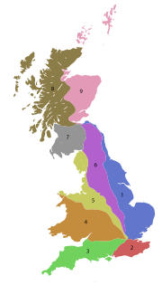
B roads in Zone 9 of the Great Britain numbering scheme
Encyclopedia
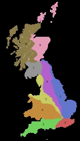
Great Britain
Great Britain or Britain is an island situated to the northwest of Continental Europe. It is the ninth largest island in the world, and the largest European island, as well as the largest of the British Isles...
of lesser importance than A roads. See the article Great Britain road numbering scheme
Great Britain road numbering scheme
The Great Britain road numbering scheme is a numbering scheme used to classify and identify all roads in Great Britain. Each road is given a single letter, which represents the road's category, and a subsequent number, with a length of between 1 and 4 digits. Originally introduced to arrange...
for the rationale behind the numbers allocated.
Zone 9 (3 digits)
| Road | From | To | Notes |
|---|---|---|---|
| B900 | Leith Leith -South Leith v. North Leith:Up until the late 16th century Leith , comprised two separate towns on either side of the river.... |
Craigleith Craigleith Craigleith is a small island in the Firth of Forth off North Berwick in East Lothian, Scotland. Its name comes from the Scottish Gaelic Creag Lìte meaning "rock of Leith". It is 24 m at its highest point.-Geography and geology:... |
|
| B924 | A90 A90 road The A90 road is a major north to south road in eastern Scotland, running from Edinburgh to Fraserburgh in Aberdeenshire.From Edinburgh, it travels west and over the Forth Road Bridge, before turning into the M90 motorway. At Perth, the M90 again becomes the A90, now running north east to Dundee... |
South Queensferry South Queensferry South Queensferry , also called Queensferry, is a former Royal Burgh in West Lothian now part of the City of Edinburgh, Scotland. It is located some ten miles to the north west of the city centre, on the shore of the Firth of Forth between the Forth Bridge and the Forth Road Bridge, approximately 8... |
|
| B927 | A915 at Leven, Fife Leven, Fife Leven is a seaside town in Fife, set in the east Central Lowlands of Scotland. It lies on the coast of the Firth of Forth at the mouth of the River Leven, north-east of Kirkcaldy and east of Glenrothes.... |
A916 at Montrave, Fife | northern ends directly opposite the West Lodge of the Montrave Estate of the Gilmour Baronets Gilmour Baronets There have been four Baronetcies created for persons with the surname Gilmour, two in the Baronetage of Nova Scotia and two in the Baronetage of the United Kingdom. The former are both extinct, but the latter two are still both extant.... |
| B936 | A913 at Den of Lindores, Fife | A92 A92 road The A92 is a major road in Fife and Angus, Scotland. It runs from Dunfermline to Stonehaven.Starting at its junction with the M90 motorway near Dunfermline, it runs north east past Cowdenbeath, Lochgelly, Kirkcaldy, Glenrothes, Ladybank and Newport-on-Tay... at Freuchie Freuchie Freuchie is a village in Fife, Scotland, at the foot of the Lomond Hills, and near Falkland. The nearest major town is Glenrothes located 4 miles to the south.The name derives from the Scottish Gaelic, fraoch, meaning heather.... , Fife |
via Auchtermuchty Auchtermuchty Auchtermuchty is a town in Fife, Scotland, situated beside Pitlour Hill nine miles north of Glenrothes. Until 1975 it was a royal burgh, established under charter of King James V in 1517. There is evidence of human habitation in the area dating back over 2,000 years, and the Romans are known to... and Falkland Falkland, Fife Falkland is a town and former royal burgh, formerly known as the Parish of Kilgour c1300AD in Fife, Scotland at the foot of the Lomond Hills.According to the 2008 population estimate, the village has a population of 1,180.- History :... |
| B937 | A913 at Lindores Lindores Lindores is a small village in Fife, Scotland, about 2 miles south-east of Newburgh. It is situated on the north-east shore of Lindores Loch, a 44 ha freshwater loch. A possible derivation of the name Lindores is 'church by the water'... , Fife |
A92 A92 road The A92 is a major road in Fife and Angus, Scotland. It runs from Dunfermline to Stonehaven.Starting at its junction with the M90 motorway near Dunfermline, it runs north east past Cowdenbeath, Lochgelly, Kirkcaldy, Glenrothes, Ladybank and Newport-on-Tay... near Ladybank Ladybank Ladybank is a town and former burgh of Fife, Scotland. It is located about north of Edinburgh, southwest of Cupar, close to the River Eden. Its 2006 population was estimated at 1,582.-History:Prior to the 18th century, this area was mostly marshland... , Fife |
|
| B938 | A92 A92 road The A92 is a major road in Fife and Angus, Scotland. It runs from Dunfermline to Stonehaven.Starting at its junction with the M90 motorway near Dunfermline, it runs north east past Cowdenbeath, Lochgelly, Kirkcaldy, Glenrothes, Ladybank and Newport-on-Tay... near Ladybank |
B9129 at Ladybank Ladybank Ladybank is a town and former burgh of Fife, Scotland. It is located about north of Edinburgh, southwest of Cupar, close to the River Eden. Its 2006 population was estimated at 1,582.-History:Prior to the 18th century, this area was mostly marshland... , Fife |
About 1 kilometres (5 furlong) |
| B939 | A916 at Craigrothie, Fife | A915 at St Andrews St Andrews St Andrews is a university town and former royal burgh on the east coast of Fife in Scotland. The town is named after Saint Andrew the Apostle.St Andrews has a population of 16,680, making this the fifth largest settlement in Fife.... |
|
| B940 | A91 A91 road The A91 is a major road in Scotland, United Kingdom. It runs from St Andrews to Bannockburn, via Cupar. Along the way, the road runs adjacent to parts of the St. Andrews Old Course and Jubilee golf courses into Guardbridge. Past Guardbridge is Clayton Caravan Park. Further towards Cupar is the Eden... at Cupar Cupar Cupar is a town and former royal burgh in Fife, Scotland. The town is situated between Dundee and the New Town of Glenrothes.According to a recent population estimate , Cupar had a population around 8,980 making the town the ninth largest settlement in Fife.-History:The town is believed to have... |
A917 near Crail Crail Crail ; ) is a former royal burgh in the East Neuk of Fife, Scotland.-History:Crail probably dates from at least as far back as the Pictish period, as the place-name includes the Pictish/Brythonic element caer, 'fort', and there is a Dark Age cross-slab preserved in the parish kirk, itself... |
passes "Scotland's Secret Bunker" (now a museum) |
| B941 | B940 at Peat Inn Peat Inn Peat Inn is a hamlet in Fife, Scotland, around seven miles south east of Cupar on the B940 and six miles south west of St Andrews. The hamlet is centred on a hotel and restaurant of the same name.- External links :*... |
A917 at Kilconquhar | |
| B942 | A917 at Balchrystie, Fife | A917 near Pittenweem Pittenweem Pittenweem is a small and secluded fishing village and civil parish tucked in the corner of Fife on the east coast of Scotland. According to the 2006 estimate, the village has a population of 1,600. At the 2001 census, the parish had a population of 1,747.... |
via Colinsburgh, Fife |
| B945 | A914/A919 at St Michaels, Fife | B946 at Tayport Tayport Tayport is located in Fife, Scotland.Te oportet alte ferri - "It is encumbent on you to carry yourself high." This actually a rather terrible pun on:"Tayport at auld Tay Ferry".... |
|
| B946 | A92 A92 road The A92 is a major road in Fife and Angus, Scotland. It runs from Dunfermline to Stonehaven.Starting at its junction with the M90 motorway near Dunfermline, it runs north east past Cowdenbeath, Lochgelly, Kirkcaldy, Glenrothes, Ladybank and Newport-on-Tay... |
B945 at Tayport Tayport Tayport is located in Fife, Scotland.Te oportet alte ferri - "It is encumbent on you to carry yourself high." This actually a rather terrible pun on:"Tayport at auld Tay Ferry".... |
via Wormit Wormit Wormit is a small town located on the banks of the Firth of Tay in north east Fife, Scotland. It is most famous for its location at the southern end of the Tay Rail Bridge. Its railway station was on a closed branch line which left the main line railway immediately at the south end of the Bridge... and Newport-on-Tay Newport-on-Tay Newport-on-Tay is a small town in the north east of Fife in Scotland, acting as a commuter suburb for Dundee. The Fife Coastal Path passes through Newport.-History:... |
| B959 | A929 | A92 A92 road The A92 is a major road in Fife and Angus, Scotland. It runs from Dunfermline to Stonehaven.Starting at its junction with the M90 motorway near Dunfermline, it runs north east past Cowdenbeath, Lochgelly, Kirkcaldy, Glenrothes, Ladybank and Newport-on-Tay... , Dundee Dundee Dundee is the fourth-largest city in Scotland and the 39th most populous settlement in the United Kingdom. It lies within the eastern central Lowlands on the north bank of the Firth of Tay, which feeds into the North Sea... |
|
| B960 | A929 | A90 A90 road The A90 road is a major north to south road in eastern Scotland, running from Edinburgh to Fraserburgh in Aberdeenshire.From Edinburgh, it travels west and over the Forth Road Bridge, before turning into the M90 motorway. At Perth, the M90 again becomes the A90, now running north east to Dundee... , Dundee Dundee Dundee is the fourth-largest city in Scotland and the 39th most populous settlement in the United Kingdom. It lies within the eastern central Lowlands on the north bank of the Firth of Tay, which feeds into the North Sea... |
|
| B969 | A92 A92 road The A92 is a major road in Fife and Angus, Scotland. It runs from Dunfermline to Stonehaven.Starting at its junction with the M90 motorway near Dunfermline, it runs north east past Cowdenbeath, Lochgelly, Kirkcaldy, Glenrothes, Ladybank and Newport-on-Tay... |
B921 | through Glenrothes Glenrothes Glenrothes is a large town situated in the heart of Fife, in east-central Scotland. It is located approximately from both Edinburgh, which lies to the south and Dundee to the north. The town had an estimated population of 38,750 in 2008, making Glenrothes the third largest settlement in Fife... , Fife |
| B970 | A86 A86 road The A86 is a major road in Scotland, United Kingdom, it runs from Spean Bridge to Kingussie. It is a primary route for all of its length.Travelling along this route carries a medium to high risk of suffering a death or serious injury accident according to EuroRAP.-References:... Kingussie Kingussie Kingussie is a small town in the Highland region of Scotland. It is one settlement in the Highland Council ward of Badenoch and Strathspey, and is the capital of the district of Badenoch. It lies beside the A9 road, although the old route of the A9 serves as the town's main street... |
A95 A95 road The A95 road is a major road of north-east Scotland connecting the A9 road in the Highlands to the A98 road near the coast.It leaves the A9 four miles north of Aviemore.It then goes:*through Drumullie;... , east of Grantown-on-Spey Grantown-on-Spey Grantown-on-Spey is a town in the Highland Council Area in Scotland.It was founded in 1765 as a planned settlement on a low plateau at Freuchie beside the river Spey at the northern edge of the Cairngorm mountains, about 20 miles South East of Inverness .It is the main town in what was the... |
runs through Feshiebridge, Inverdruie Inverdruie Inverdruie is a small rural hamlet, that lies 2 miles southeast of Aviemore, in the valley of the River Spey, in the west Cairngorms National Park, in Badenoch and Strathspey, Inverness-shire, Scottish Highlands and is in the Scottish council area of Highland.The single track B970 B road which... and Nethy Bridge Nethy Bridge Nethy Bridge is a small village in Strathspey in the Highland Council Area of Scotland. It is located in the historical parish of Abernethy and Kincardine... along east side of River Spey River Spey The River Spey is a river in the northeast of Scotland, the second longest and the fastest-flowing river in Scotland... |
| B977 | A980 A980 road The A980 road is a relatively short main road in north-east Scotland.The A980 connects the A944 road with the trunk A93 road.Route*A944 between Alford, Aberdeenshire and Bridge of Alford*Muir of Fowlis*Craigievar Castle*Crossroads... north of Banchory Banchory Banchory is a burgh or town in Aberdeenshire, Scotland, lying approximately 18 miles west of Aberdeen, near where the Feugh River meets the River Dee.- Overview :... |
A90 A90 road The A90 road is a major north to south road in eastern Scotland, running from Edinburgh to Fraserburgh in Aberdeenshire.From Edinburgh, it travels west and over the Forth Road Bridge, before turning into the M90 motorway. At Perth, the M90 again becomes the A90, now running north east to Dundee... at Balmedie |
Tortuous route by way of Landerberry, Echt Echt, Aberdeenshire Echt is an Aberdeenshire crossroads village in northeast Scotland with a population of approximately 300 people. Echt has a number of prehistoric remains, including the so called Barmekin of Echt which is on a hill to the northwest... , Dunecht Dunecht Dunecht is a slightly linear village on the A944 road in north-east Aberdeenshire in Scotland. It is not to be confused with Echt.Dunecht is located 12 miles west of the city of Aberdeen and is situated by the confluence of the Kinnernie and Bervie burns.Formerly known as Waterton, it was renamed... , Lyne of Skene, Leylodge, Kintore Kintore, Aberdeenshire Kintore is a town and former royal burgh near Inverurie in Aberdeenshire, Scotland, now bypassed by the A96 road between Aberdeen and Inverness. The name Kintore comes from the Gaelic, Ceann Tòrr. Ceann means the head, or the end, and Tòrr means a round hill. So the name signifies that the town... , Hatton of Fintray Hatton of Fintray Hatton of Fintray, commonly referred to as Fintray, is a village on the River Don in Aberdeenshire, Scotland, in the parish of Fintray. It was a textile village and its church dates from 1821, and there used to be a nearby ferry crossing the river.... , Cothall and Belhelvie Belhelvie Belhelvie is a small village and civil parish in Aberdeenshire in Scotland. The parish has a population of 3,802, of which 1,653 are in the village. It was the site of a suspected water pollution incident in 2006.-Notable people:... |
| B979 | Stonehaven Stonehaven Stonehaven is a town in Aberdeenshire, Scotland. It lies on Scotland's northeast coast and had a population of 9,577 in 2001 census.Stonehaven, county town of Kincardineshire, grew around an Iron Age fishing village, now the "Auld Toon" , and expanded inland from the seaside... |
B999 near Whitecairns Whitecairns Whitecairns is a village in the Formartine area of Aberdeenshire, Scotland, lying north of Potterton and south of Pitmedden on the B999 road.... |
Tortuous route by way of Netherley, Maryculter Maryculter Maryculter or Kirkton of Maryculter is a village in the Lower Deeside area of Aberdeenshire, Scotland. The River Dee separates it from the town of Peterculter, and the B979 road runs through Maryculter. There are two hotels: The Old Mill Inn, a former coaching inn that dates back 200 years, and... , Peterculter Peterculter Peterculter , also known as Culter, is a suburb of Aberdeen, Scotland approximately eight miles inland from Aberdeen city centre. Peterculter is situated along the northern banks of the River Dee in the vicinity of the confluences with Crynoch Burn and Leuchar Burn... , Kirkton of Skene, Blackburn Blackburn, Aberdeenshire Blackburn is a rapidly growing commuter town just northwest of Aberdeen, Scotland, and is situated in Aberdeenshire. It has an industrial estate. It has a small primary school and a £5 million community hall which was publicly opened by The Princess Royal in 2005.- References :... , Hatton of Fintray Hatton of Fintray Hatton of Fintray, commonly referred to as Fintray, is a village on the River Don in Aberdeenshire, Scotland, in the parish of Fintray. It was a textile village and its church dates from 1821, and there used to be a nearby ferry crossing the river.... and Newmachar Newmachar Newmachar is a village in the north-east of Scotland located within the Aberdeenshire local authority. Situated 10 miles to the north-west of Aberdeen, the settlement has an estimated population of 2,400.-Overview:... |
| B975 | A941, Dufftown Dufftown Dufftown is a burgh in Banffshire, Scotland.The town was originally named Mortlach in the Middle Ages, until the 19th century when the Earl of Fife built the town as a housing for soldiers returning home from war... |
B9014, Dufftown Dufftown Dufftown is a burgh in Banffshire, Scotland.The town was originally named Mortlach in the Middle Ages, until the 19th century when the Earl of Fife built the town as a housing for soldiers returning home from war... |
|
| B993 | B976 between Birse Birse Birse is a parish in the Lower Deeside area of Aberdeenshire, Scotland, which includes the communities of Finzean and Ballogie. However the name Birse is often used to refer only to the northwestern part of the parish which lies on the south side of the River Dee, Aberdeenshire, opposite the... and Marywell Marywell Marywell is a village in Angus, Scotland, that is north of Arbroath, in the parish of St Vigeans.-Sources:* in the Gazetteer for Scotland.... |
A947 A947 road The A947 is a single-carriageway road in Scotland that links Aberdeen to Banff via several towns in Aberdeenshire, including Newmachar, Oldmeldrum, Fyvie and Turriff.Approximately half a mile before Oldmeldrum are remarkable views of Bennachie.-References:*... at Whiterashes Whiterashes Whiterashes is a hamlet in the Formartine area of Aberdeenshire, Scotland, lying to the north-west of Newmachar and south-east of Oldmeldrum on the A947 road.-Sources:* in the Gazetteer for Scotland.... |
by way of Potarch Potarch Potarch is a hamlet in Aberdeenshire, Scotland, with a bridge across the River Dee.It is a popular location with tourists and day trippers, and has a hotel.-References:... , Mid Beltie, Torphins Torphins Torphins is a village in Royal Deeside, Aberdeenshire, Scotland, about 20 miles west of Aberdeen. It is on the A980 road, about 6 miles north-west of Banchory, and was once served by the Great North of Scotland Railway.... , Tillyfourie, Monymusk Monymusk Monymusk is a planned village in the Marr area of Aberdeenshire, Scotland which was almost entirely rebuilt in 1840, although its history dates back to 1170.It is a site for fishing on the nearby River Don.-External links:* *... , Kemnay Kemnay Kemnay is a town west of Aberdeen in Scotland. It has a population of about 4,500 .- History :The villagename Kemnay is believed to originate from the Celtic words that mean bend and river due to... , Port Elphinstone and Nether Crimond |
| B999 | Blackdog (A90 A90 road The A90 road is a major north to south road in eastern Scotland, running from Edinburgh to Fraserburgh in Aberdeenshire.From Edinburgh, it travels west and over the Forth Road Bridge, before turning into the M90 motorway. At Perth, the M90 again becomes the A90, now running north east to Dundee... ) |
B9170 nr Tarves Tarves Tarves is a small Aberdeenshire Village, situated in the formatine area of North East Scotland and lies between Oldmeldrum and Methlick. Much of the village was planned and laid out by the Marquess of Aberdeen in the 19th century but the history of the parish goes back considerably before that.... |
Zone 9 (4 digits)
| Road | From | To | Notes |
|---|---|---|---|
| B9000 | Pitmedden Pitmedden Pitmedden is a rural village in Aberdeenshire, Scotland, situated midway between Ellon and Oldmeldrum, and approximately distant from Aberdeen. In addition to local shops, primary school, church, village hall and parks, the village is home to the National Trust for Scotland's Pitmedden Garden and... |
Newburgh Newburgh, Aberdeenshire Newburgh is a coastal village in Aberdeenshire, Scotland. The village dates to 1261 AD, when Lord Sinclair wanted to establish a chapel in the area. Originally built as a school, somewhat later the chapel of Holy Rood was established.-Geography:... |
|
| B9001 | Inverurie Inverurie Inverurie is a Royal Burgh and town in Aberdeenshire, Scotland, approximately north west of Aberdeen on the A96 road and is served by Inverurie railway station on the Aberdeen to Inverness Line... |
A97 A97 road The A97 is a major road in Aberdeenshire, Scotland. It runs south from Banff on the north coast through Aberchirder, Huntly, Rhynie and Mossat before terminating at its junction with the A93 road at Dinnet.... near Forgue |
|
| B9002 | Oyne Oyne Oyne is a small village in rural Aberdeenshire at the bottom of Bennachie in Scotland.-Locality:The village has limited local resources. It once had a railway station, and now has a daily bus service to Inverurie away and to Huntly. The area is popular with commuters to Inverurie/Huntly/Aberdeen,... |
A941 west of Rhynie | |
| B9003 | A975, nr Auchmacoy | Collieston Collieston Collieston is a small former fishing village on the North Sea coast in Aberdeenshire, Scotland. The village lies just north of the Sands of Forvie Special Protection Area, between Cruden Bay and Newburgh.-History:... |
|
| B9005 | A90 A90 road The A90 road is a major north to south road in eastern Scotland, running from Edinburgh to Fraserburgh in Aberdeenshire.From Edinburgh, it travels west and over the Forth Road Bridge, before turning into the M90 motorway. At Perth, the M90 again becomes the A90, now running north east to Dundee... south of Ellon Ellon, Aberdeenshire Ellon is a town in Aberdeenshire, Scotland, approximately north of Aberdeen, lying on the River Ythan which has one of the few undeveloped river estuaries on the Eastern coast of Scotland. It is in the ancient region of Formartine... |
Fyvie Fyvie Fyvie is a village in the Formartine area of Aberdeenshire, Scotland.-Fyvie Castle:Fyvie Castle is reputed to have been built by King William the Lyon in the early thirteenth century... |
|
| B9006 | Inverness Inverness Inverness is a city in the Scottish Highlands. It is the administrative centre for the Highland council area, and is regarded as the capital of the Highlands of Scotland... |
Fort George Fort George, Highland Fort George , is a large 18th century fortress near Ardersier, to the north-east of Inverness in the Highland council area of Scotland. It was built to pacify the Scottish Highlands in the aftermath of the Jacobite rising of 1745, replacing an earlier Fort George built with the same aim after the... |
|
| B9007 | A938 east of Carrbridge Carrbridge Carrbridge is a village in Badenoch and Strathspey in the Scottish Highlands. It lies off the A9 road on the A938 road, west of Skye of Curr, southeast of Findhom Bridge, near Bogroy.It has the oldest stone bridge in the Highlands and nearby ancient pine forest contains the Landmark Forest... |
A940 at Logie | |
| B9008 | Tomintoul Tomintoul Tomintoul is a village in the Moray council area of Scotland; until 1975 it was located in the county of Banffshire.It is said to be the highest village in the Scottish Highlands, but at is still significantly lower than the highest village in Scotland .The village was laid out on a grid pattern... |
A97 A97 road The A97 is a major road in Aberdeenshire, Scotland. It runs south from Banff on the north coast through Aberchirder, Huntly, Rhynie and Mossat before terminating at its junction with the A93 road at Dinnet.... at Bridge of Avon |
|
| B9009 | Dufftown Dufftown Dufftown is a burgh in Banffshire, Scotland.The town was originally named Mortlach in the Middle Ages, until the 19th century when the Earl of Fife built the town as a housing for soldiers returning home from war... |
B9008 near Glenlivet Glenlivet Glenlivet is the glen in the Scottish Highlands through which the River Livet flows.The river rises high in the Ladder Hills. It flows gently down through the village of Tomnavoulin and onto the Bridgend of Glenlivet, flowing under the ancient packhorse bridge before emptying into the River Avon,... |
|
| B9010 | Elgin Elgin, Moray Elgin is a former cathedral city and Royal Burgh in Moray, Scotland. It is the administrative and commercial centre for Moray. The town originated to the south of the River Lossie on the higher ground above the flood plain. Elgin is first documented in the Cartulary of Moray in 1190... |
Forres Forres Forres , is a town and former royal burgh situated in the north of Scotland on the Moray coast, approximately 30 miles east of Inverness. Forres has been a winner of the Scotland in Bloom award on several occasions... |
|
| B9011 | Forres Forres Forres , is a town and former royal burgh situated in the north of Scotland on the Moray coast, approximately 30 miles east of Inverness. Forres has been a winner of the Scotland in Bloom award on several occasions... |
Findhorn Findhorn Findhorn is a village in Moray, Scotland. It is located on the eastern shore of Findhorn Bay and immediately south of the Moray Firth. Findhorn is 3 miles northwest of Kinloss, and about 5 miles by road from Forres.... |
|
| B9012 | Elgin Elgin, Moray Elgin is a former cathedral city and Royal Burgh in Moray, Scotland. It is the administrative and commercial centre for Moray. The town originated to the south of the River Lossie on the higher ground above the flood plain. Elgin is first documented in the Cartulary of Moray in 1190... |
B9040 east of Hopeman Hopeman Hopeman is a seaside village in Moray, Scotland, on the coast of the Moray Firth, founded in 1805 to house and re-employ people displaced during the Highland clearances. The population is around 1 000 people in approximately 670 households.-The village:... |
|
| B9013 | Burghead Burghead Burghead is a small town in Moray, Scotland, about 8 miles north-west of Elgin. The town is mainly built on a Peninsula which projects north-westward into the Moray Firth, meaning that most of the town has sea on 3 sides. The present town was built between 1805 and 1809, destroying in the... |
A96 A96 road The A96 is a major road in the North of Scotland.It runs generally west/north-west from Aberdeen, bypassing Kintore, Inverurie, Huntly and Forres, and running through Keith, Fochabers, Elgin and Nairn... west of Elgin Elgin, Moray Elgin is a former cathedral city and Royal Burgh in Moray, Scotland. It is the administrative and commercial centre for Moray. The town originated to the south of the River Lossie on the higher ground above the flood plain. Elgin is first documented in the Cartulary of Moray in 1190... |
|
| B9014 | Keith Keith, Moray Keith is a small town in the Moray council area in north east Scotland. It has a population of around 4,500.... |
Dufftown Dufftown Dufftown is a burgh in Banffshire, Scotland.The town was originally named Mortlach in the Middle Ages, until the 19th century when the Earl of Fife built the town as a housing for soldiers returning home from war... |
|
| B9015 | Rothes Rothes Rothes is a town in Moray, Scotland, south of Elgin and on the banks of the River Spey. The village has a population of 1209 .At the south end of the village lie the remains of Rothes Castle, which dates from the 13th century... |
Kingston Kingston, Moray Kingston on Spey is a small coastal village in Moray, Scotland. It is situated immediately north of Garmouth at the western side of the mouth of the River Spey on the coast of the Moray Firth. Kingston was founded in 1784 and was named after Kingston upon Hull, in East Yorkshire.Kingston's past... |
|
| B9016 | A98 A98 road The A98 road is a major coastal road of northeast Scotland passing through Moray and Aberdeenshire. The A98 is no longer a primary route, with this status being removed shortly after the A92 was renumbered A90.... junction with A990 |
A96 A96 road The A96 is a major road in the North of Scotland.It runs generally west/north-west from Aberdeen, bypassing Kintore, Inverurie, Huntly and Forres, and running through Keith, Fochabers, Elgin and Nairn... north of Keith Keith, Moray Keith is a small town in the Moray council area in north east Scotland. It has a population of around 4,500.... |
|
| B9017 | Newmill | A96 A96 road The A96 is a major road in the North of Scotland.It runs generally west/north-west from Aberdeen, bypassing Kintore, Inverurie, Huntly and Forres, and running through Keith, Fochabers, Elgin and Nairn... west of Keith Keith, Moray Keith is a small town in the Moray council area in north east Scotland. It has a population of around 4,500.... |
|
| B9018 | Cullen | A95 A95 road The A95 road is a major road of north-east Scotland connecting the A9 road in the Highlands to the A98 road near the coast.It leaves the A9 four miles north of Aviemore.It then goes:*through Drumullie;... east of Keith Keith, Moray Keith is a small town in the Moray council area in north east Scotland. It has a population of around 4,500.... |
|
| B9019 | Seafield Street (A98 A98 road The A98 road is a major coastal road of northeast Scotland passing through Moray and Aberdeenshire. The A98 is no longer a primary route, with this status being removed shortly after the A92 was renumbered A90.... ), Portsoy Portsoy Portsoy is a burgh in Aberdeenshire, Scotland, formerly in the county of Banffshire. The original name of the town was Pert Soaidh, which translates as 'The wooded place of the warriors... |
Shore Street, Portsoy Portsoy Portsoy is a burgh in Aberdeenshire, Scotland, formerly in the county of Banffshire. The original name of the town was Pert Soaidh, which translates as 'The wooded place of the warriors... |
|
| B9020 | A942 south of Findochty Findochty Findochty is a village in Banffshire, Scotland, 4 miles east of the town of Buckie.Findochty stands on the shores of the Moray Firth. The Gaelic name of the village was recorded by Diack in his own transcription method as fanna-guchti which is unclear in meaning... |
A942 west of Findochty Findochty Findochty is a village in Banffshire, Scotland, 4 miles east of the town of Buckie.Findochty stands on the shores of the Moray Firth. The Gaelic name of the village was recorded by Diack in his own transcription method as fanna-guchti which is unclear in meaning... |
|
| B9021 | A942, Portknockie Portknockie Portknockie is a coastal village on the Moray Firth in northeast Scotland, in Moray. Portknockie is a coastal village on the Moray Firth in northeast Scotland, in Moray. Portknockie is a coastal village on the Moray Firth in northeast Scotland, in Moray. (Family historians will note that this... |
Portknockie Portknockie Portknockie is a coastal village on the Moray Firth in northeast Scotland, in Moray. Portknockie is a coastal village on the Moray Firth in northeast Scotland, in Moray. Portknockie is a coastal village on the Moray Firth in northeast Scotland, in Moray. (Family historians will note that this... harbour |
|
| B9022 | Portsoy Portsoy Portsoy is a burgh in Aberdeenshire, Scotland, formerly in the county of Banffshire. The original name of the town was Pert Soaidh, which translates as 'The wooded place of the warriors... |
Huntly | |
| B9023 | Aberchirder Aberchirder Aberchirder , known locally as Foggieloan or Foggie, is a village in Aberdeenshire, Scotland, situated on the A97 road six miles west of Turriff.- History :... |
Brodiesord (B9022) | |
| B9024 | Turriff Turriff Turriff is a town and civil parish in Aberdeenshire in Scotland. It is approximately above sea level, and has a population of 5,708.Turriff is known locally as Turra in the Doric dialect of Scots... |
B9001 south of Forgue | |
| B9025 | Turriff Turriff Turriff is a town and civil parish in Aberdeenshire in Scotland. It is approximately above sea level, and has a population of 5,708.Turriff is known locally as Turra in the Doric dialect of Scots... |
A98 A98 road The A98 road is a major coastal road of northeast Scotland passing through Moray and Aberdeenshire. The A98 is no longer a primary route, with this status being removed shortly after the A92 was renumbered A90.... south east of Portsoy Portsoy Portsoy is a burgh in Aberdeenshire, Scotland, formerly in the county of Banffshire. The original name of the town was Pert Soaidh, which translates as 'The wooded place of the warriors... |
|
| B9026 | Macduff Macduff, Aberdeenshire Macduff is a town in the Banff and Buchan area of Aberdeenshire, Scotland. Macduff is situated on Banff Bay and faces the town of Banff across the estuary of the River Deveron... |
A947 A947 road The A947 is a single-carriageway road in Scotland that links Aberdeen to Banff via several towns in Aberdeenshire, including Newmachar, Oldmeldrum, Fyvie and Turriff.Approximately half a mile before Oldmeldrum are remarkable views of Bennachie.-References:*... south of Macduff Macduff, Aberdeenshire Macduff is a town in the Banff and Buchan area of Aberdeenshire, Scotland. Macduff is situated on Banff Bay and faces the town of Banff across the estuary of the River Deveron... |
|
| B9027 | Cuminestown Cuminestown Cuminestown is a small village in the heart of Aberdeenshire, approximately six miles east of Turriff.As of 2004, it has an estimated population of 500 and a primary school called Monquhitter Primary School which also covers the small hamlet of Garmond, about a mile north of Cuminestown.-External... |
A98 A98 road The A98 road is a major coastal road of northeast Scotland passing through Moray and Aberdeenshire. The A98 is no longer a primary route, with this status being removed shortly after the A92 was renumbered A90.... north of New Byth New Byth New Byth is a small inland planned village in the Banff and Buchan committee area of Aberdeenshire, Scotland that lies a few miles northeast of Cuminestown and was built in the 18th century.-Sources:* in the Gazetteer for Scotland.... |
|
| B9028 | A948, South of New Deer New Deer New Deer is a settlement in Aberdeenshire, North East Scotland that lies in the valley of Deer. It was founded after monks from Deer Abbey, Old Deer built a chapel at Auchreddie, which translates as "field of the bog myrtle". Around 1507 the register of Deer Abbey lists its lands in the "new... |
A981, North of New Deer | New Deer Bypass |
| B9029 | Old Deer Old Deer Old Deer a parish and village in the district of Buchan, Aberdeenshire, Scotland. The population as of 1901 was 4,313. The village lies on the Deer or South Ugie Water, 10.1 miles west of Peterhead, and two miles from Mintlaw station on the Great North of Scotland Railway Company's branch line... (B9030) |
A98 A98 road The A98 road is a major coastal road of northeast Scotland passing through Moray and Aberdeenshire. The A98 is no longer a primary route, with this status being removed shortly after the A92 was renumbered A90.... near New Deer New Deer New Deer is a settlement in Aberdeenshire, North East Scotland that lies in the valley of Deer. It was founded after monks from Deer Abbey, Old Deer built a chapel at Auchreddie, which translates as "field of the bog myrtle". Around 1507 the register of Deer Abbey lists its lands in the "new... |
|
| B9030 | Auchnagatt Auchnagatt Auchnagatt is a village and rural area in Buchan, Aberdeenshire, Scotland, situated on the Ebrie Burn and on the A948 road between Ellon and New Deer.- Schools :... (A948) |
Old Deer Old Deer Old Deer a parish and village in the district of Buchan, Aberdeenshire, Scotland. The population as of 1901 was 4,313. The village lies on the Deer or South Ugie Water, 10.1 miles west of Peterhead, and two miles from Mintlaw station on the Great North of Scotland Railway Company's branch line... (A950) |
|
| B9031 | Fraserburgh Fraserburgh Fraserburgh is a town in Aberdeenshire, Scotland with a population recorded in the 2001 Census at 12,454 and estimated at 12,630 in 2006. It lies at the extreme northeast corner of Aberdeenshire, around north of Aberdeen, and north of Peterhead... (A98 A98 road The A98 road is a major coastal road of northeast Scotland passing through Moray and Aberdeenshire. The A98 is no longer a primary route, with this status being removed shortly after the A92 was renumbered A90.... ) |
Macduff Macduff Macduff may refer to:* Macduff , the character in Shakespeare's Macbeth* Macduff, Aberdeenshire, the former burgh which is now within the Aberdeenshire council area of Scotland* the Clan MacDuff, a Scottish clan... (A98 A98 road The A98 road is a major coastal road of northeast Scotland passing through Moray and Aberdeenshire. The A98 is no longer a primary route, with this status being removed shortly after the A92 was renumbered A90.... ) |
|
| B9032 | Near Rathen (south of Fraserburgh Fraserburgh Fraserburgh is a town in Aberdeenshire, Scotland with a population recorded in the 2001 Census at 12,454 and estimated at 12,630 in 2006. It lies at the extreme northeast corner of Aberdeenshire, around north of Aberdeen, and north of Peterhead... , A90 A90 road The A90 road is a major north to south road in eastern Scotland, running from Edinburgh to Fraserburgh in Aberdeenshire.From Edinburgh, it travels west and over the Forth Road Bridge, before turning into the M90 motorway. At Perth, the M90 again becomes the A90, now running north east to Dundee... ) |
B9031 near Coburty | |
| B9033 | Crimond Crimond Crimond is a village in the northeast of Scotland, located nine miles northwest of the port of Peterhead and just over two miles from the coast.- Local area :... (A90 A90 road The A90 road is a major north to south road in eastern Scotland, running from Edinburgh to Fraserburgh in Aberdeenshire.From Edinburgh, it travels west and over the Forth Road Bridge, before turning into the M90 motorway. At Perth, the M90 again becomes the A90, now running north east to Dundee... ) |
Fraserburgh Fraserburgh Fraserburgh is a town in Aberdeenshire, Scotland with a population recorded in the 2001 Census at 12,454 and estimated at 12,630 in 2006. It lies at the extreme northeast corner of Aberdeenshire, around north of Aberdeen, and north of Peterhead... (A90 A90 road The A90 road is a major north to south road in eastern Scotland, running from Edinburgh to Fraserburgh in Aberdeenshire.From Edinburgh, it travels west and over the Forth Road Bridge, before turning into the M90 motorway. At Perth, the M90 again becomes the A90, now running north east to Dundee... ) |
|
| B9034 | A90 A90 road The A90 road is a major north to south road in eastern Scotland, running from Edinburgh to Fraserburgh in Aberdeenshire.From Edinburgh, it travels west and over the Forth Road Bridge, before turning into the M90 motorway. At Perth, the M90 again becomes the A90, now running north east to Dundee... in Fraserburgh Fraserburgh Fraserburgh is a town in Aberdeenshire, Scotland with a population recorded in the 2001 Census at 12,454 and estimated at 12,630 in 2006. It lies at the extreme northeast corner of Aberdeenshire, around north of Aberdeen, and north of Peterhead... |
A98 A98 road The A98 road is a major coastal road of northeast Scotland passing through Moray and Aberdeenshire. The A98 is no longer a primary route, with this status being removed shortly after the A92 was renumbered A90.... in Fraserburgh Fraserburgh Fraserburgh is a town in Aberdeenshire, Scotland with a population recorded in the 2001 Census at 12,454 and estimated at 12,630 in 2006. It lies at the extreme northeast corner of Aberdeenshire, around north of Aberdeen, and north of Peterhead... |
|
| B9037 | A985 at Cairneyhill Cairneyhill Cairneyhill is a small village in west Fife, Scotland. It is 3 miles west of Dunfermline, on the A994, and has a population of around 2,600.The village's architecture is a mix of old weavers' cottages and modern suburban housing estates. Most residents work either locally or commute to Edinburgh,... |
A907 at Blairhall Blairhall Blairhall is a village in West Fife, Scotland. It is situated approximately west of Comrie, and west of Dunfermline. The village was originally a small hamlet but was expanded in 1911 to house the miners from a nearby colliery... |
|
| B9038 | Inverboyndie | Whitehills Whitehills Whitehills is a small fishing village in Aberdeenshire, Scotland that lies a few miles northwest of Banff.-Sources:* in the Gazetteer for Scotland.... |
|
| B9039 | Ardersier Ardersier Ardersier is a small former fishing village in the Scottish Highlands, on the Moray Firth, east of Inverness, near Fort George, and Nairn . Its name is an anglicisation of the Gaelic "Àird nan Saor", or "Headland of the joiners", one local legend being that carpenters working on the construction... |
A96 A96 road The A96 is a major road in the North of Scotland.It runs generally west/north-west from Aberdeen, bypassing Kintore, Inverurie, Huntly and Forres, and running through Keith, Fochabers, Elgin and Nairn... east of Balloch Balloch, Highland Balloch is a residential village located 4 miles east of the city of Inverness, Scotland.Many children living in the area attend Culloden Academy. Balloch also has a local shop which is currently having an extension constructed. There is a village hall, a bowling club, a village trust and a .Like... |
|
| B9040 | Lossiemouth Lossiemouth Lossiemouth is a town in Moray, Scotland. Originally the port belonging to Elgin, it became an important fishing town. Although there has been over a 1,000 years of settlement in the area, the present day town was formed over the past 250 years and consists of four separate communities that... |
Burghead Burghead Burghead is a small town in Moray, Scotland, about 8 miles north-west of Elgin. The town is mainly built on a Peninsula which projects north-westward into the Moray Firth, meaning that most of the town has sea on 3 sides. The present town was built between 1805 and 1809, destroying in the... |
|
| B9041 | A961 A961 road The A961 is a single-carriageway road on the eastern side of Scapa Flow in the Orkney Islands, connecting the town of Kirkwall on the Orkney Mainland to Burwick at the southern end of South Ronaldsay.... near Burwick |
Cleat | |
| B9042 | A961 A961 road The A961 is a single-carriageway road on the eastern side of Scapa Flow in the Orkney Islands, connecting the town of Kirkwall on the Orkney Mainland to Burwick at the southern end of South Ronaldsay.... south of St Margaret's Hope St Margaret's Hope St Margaret's Hope, known locally as The Hope , is a village in the Orkney Islands, situated off the north-east coast of Scotland. It has a population of about 550, making it Orkney's third largest settlement after Kirkwall and Stromness.... |
Herston Herston, Orkney Herston is a village on South Ronaldsay, Orkney. Herston is historically a fishing village but has no industry to speak of now that Herston Hikers Hostel is now inactive.... |
|
| B9043 | St Margaret's Hope St Margaret's Hope St Margaret's Hope, known locally as The Hope , is a village in the Orkney Islands, situated off the north-east coast of Scotland. It has a population of about 550, making it Orkney's third largest settlement after Kirkwall and Stromness.... |
Hoxa | |
| B9044 | A961 A961 road The A961 is a single-carriageway road on the eastern side of Scapa Flow in the Orkney Islands, connecting the town of Kirkwall on the Orkney Mainland to Burwick at the southern end of South Ronaldsay.... north of St Margaret's Hope St Margaret's Hope St Margaret's Hope, known locally as The Hope , is a village in the Orkney Islands, situated off the north-east coast of Scotland. It has a population of about 550, making it Orkney's third largest settlement after Kirkwall and Stromness.... |
South Cara | |
| B9045 | Oil terminal, Flotta Flotta Flotta is a small island in Orkney, Scotland, lying in Scapa Flow. The island is known for its large oil terminal and is linked by Orkney Ferries to Houton on the Orkney Mainland and Lyness and Longhope on Hoy.... |
Quoy Ness, Flotta Flotta Flotta is a small island in Orkney, Scotland, lying in Scapa Flow. The island is known for its large oil terminal and is linked by Orkney Ferries to Houton on the Orkney Mainland and Lyness and Longhope on Hoy.... |
|
| B9046 | B9045, Flotta Flotta Flotta is a small island in Orkney, Scotland, lying in Scapa Flow. The island is known for its large oil terminal and is linked by Orkney Ferries to Houton on the Orkney Mainland and Lyness and Longhope on Hoy.... |
Kirk Bay, Flotta Flotta Flotta is a small island in Orkney, Scotland, lying in Scapa Flow. The island is known for its large oil terminal and is linked by Orkney Ferries to Houton on the Orkney Mainland and Lyness and Longhope on Hoy.... |
|
| B9047 | South Walls South Walls South Walls is an inhabited island adjacent to Hoy in Orkney, Scotland. The name is a corruption of "Sooth Was", which means the "southern voes" - as with Kirkwall, it was assumed that it was a mispronunciation of "walls".... |
North of Linksness, Hoy Hoy Hoy is an island in Orkney, Scotland. With an area of it is the second largest in the archipelago after the Mainland. It is connected by a causeway called The Ayre to South Walls... |
|
| B9048 | B9047 west of Lyness Lyness Lyness is a village on the east coast of the island of Hoy, Orkney.During the 1920's Lyness was briefly the headquarters of the metal salvage firm of Cox and Danks's raising of the German High Seas Fleet, scuttled by the Germans on June 21st 1919 during the Armistice.During the Second World War it... , Hoy Hoy Hoy is an island in Orkney, Scotland. With an area of it is the second largest in the archipelago after the Mainland. It is connected by a causeway called The Ayre to South Walls... |
Lyness Lyness Lyness is a village on the east coast of the island of Hoy, Orkney.During the 1920's Lyness was briefly the headquarters of the metal salvage firm of Cox and Danks's raising of the German High Seas Fleet, scuttled by the Germans on June 21st 1919 during the Armistice.During the Second World War it... , Hoy Hoy Hoy is an island in Orkney, Scotland. With an area of it is the second largest in the archipelago after the Mainland. It is connected by a causeway called The Ayre to South Walls... |
|
| B9049 | B9047 west of Linksness, Hoy Hoy Hoy is an island in Orkney, Scotland. With an area of it is the second largest in the archipelago after the Mainland. It is connected by a causeway called The Ayre to South Walls... |
B9047 south of Linksness, Hoy Hoy Hoy is an island in Orkney, Scotland. With an area of it is the second largest in the archipelago after the Mainland. It is connected by a causeway called The Ayre to South Walls... |
|
| B9050 | Eastern end of A960 | Sandside Bay, Orkney | |
| B9051 | Eastern end of A960 | Deer Sound, Orkney | |
| B9052 | A961 A961 road The A961 is a single-carriageway road on the eastern side of Scapa Flow in the Orkney Islands, connecting the town of Kirkwall on the Orkney Mainland to Burwick at the southern end of South Ronaldsay.... , east of St Mary's |
A960, near Foubister | |
| B9053 | A964, south of Kirkwall Kirkwall Kirkwall is the biggest town and capital of Orkney, off the coast of northern mainland Scotland. The town is first mentioned in Orkneyinga saga in the year 1046 when it is recorded as the residence of Rögnvald Brusason the Earl of Orkney, who was killed by his uncle Thorfinn the Mighty... |
Scapa Bay | |
| B9054 | Shore Street, Kirkwall Kirkwall Kirkwall is the biggest town and capital of Orkney, off the coast of northern mainland Scotland. The town is first mentioned in Orkneyinga saga in the year 1046 when it is recorded as the residence of Rögnvald Brusason the Earl of Orkney, who was killed by his uncle Thorfinn the Mighty... |
A960, Kirkwall Kirkwall Kirkwall is the biggest town and capital of Orkney, off the coast of northern mainland Scotland. The town is first mentioned in Orkneyinga saga in the year 1046 when it is recorded as the residence of Rögnvald Brusason the Earl of Orkney, who was killed by his uncle Thorfinn the Mighty... |
|
| B9055 | A965, Stenness Stenness Stenness is a village and parish on the Orkney Mainland in Scotland. It contains several notable prehistoric monuments including the Standing Stones of Stenness and the Ring of Brodgar.-Geography:... , Orkney |
B9056, Aith, Orkney | |
| B9056 | A967, Voy Voy Voy is a settlement in the Orkney Islands of the north of Scotland.It is three miles north of the town of Stromness a few hundred yards east of the A967 road.- External links :... |
A967, Bursay | |
| B9057 | A966, Evie Evie Evie is a former parish and village on The Mainland, Orkney, Scotland. It now forms part of the civil parish of Evie and Rendall.-Economy:... |
B9056, Aith | |
| B9058 | B9059 east of Balfour Balfour, Orkney Balfour is a village on the island of Shapinsay, Orkney. The village is situated on Elwick Bay, which was used as an anchorage by Haakon IV of Norway before sailing south to eventual defeat at the Battle of Largs. Today, the village still possesses a harbour, with mock defensive walls constructed... , Shapinsay Shapinsay Shapinsay is one of the Orkney Islands off the north coast of mainland Scotland. There is one village on the island, Balfour, from which roll-on/roll-off car ferries sail to Kirkwall on the Orkney Mainland... |
Ness of Ork, Shapinsay Shapinsay Shapinsay is one of the Orkney Islands off the north coast of mainland Scotland. There is one village on the island, Balfour, from which roll-on/roll-off car ferries sail to Kirkwall on the Orkney Mainland... |
|
| B9059 | Balfour Balfour, Orkney Balfour is a village on the island of Shapinsay, Orkney. The village is situated on Elwick Bay, which was used as an anchorage by Haakon IV of Norway before sailing south to eventual defeat at the Battle of Largs. Today, the village still possesses a harbour, with mock defensive walls constructed... , Shapinsay Shapinsay Shapinsay is one of the Orkney Islands off the north coast of mainland Scotland. There is one village on the island, Balfour, from which roll-on/roll-off car ferries sail to Kirkwall on the Orkney Mainland... |
Haco's Ness, Shapinsay Shapinsay Shapinsay is one of the Orkney Islands off the north coast of mainland Scotland. There is one village on the island, Balfour, from which roll-on/roll-off car ferries sail to Kirkwall on the Orkney Mainland... |
|
| B9060 | Whitehall Village, Stronsay Stronsay Stronsay is an island in Orkney, off the north coast of Scotland. The main village is Whitehall, home to a heritage centre. It is in size, and at its highest point.... |
B9062 | |
| B9061 | B9062 at Aith, Stronsay Stronsay Stronsay is an island in Orkney, off the north coast of Scotland. The main village is Whitehall, home to a heritage centre. It is in size, and at its highest point.... |
Rothiesholm, Stronsay Stronsay Stronsay is an island in Orkney, off the north coast of Scotland. The main village is Whitehall, home to a heritage centre. It is in size, and at its highest point.... |
|
| B9062 | North end of Stronsay Stronsay Stronsay is an island in Orkney, off the north coast of Scotland. The main village is Whitehall, home to a heritage centre. It is in size, and at its highest point.... |
South end of Stronsay Stronsay Stronsay is an island in Orkney, off the north coast of Scotland. The main village is Whitehall, home to a heritage centre. It is in size, and at its highest point.... |
|
| B9063 | Veness, Eday Eday Eday is one of the Orkney Islands, which are located to the north of the Scottish mainland in the United Kingdom. Eday is located in the North Isles of Orkney, and is about north of the main island of Orkney Mainland... |
Calf Sound, Eday Eday Eday is one of the Orkney Islands, which are located to the north of the Scottish mainland in the United Kingdom. Eday is located in the North Isles of Orkney, and is about north of the main island of Orkney Mainland... |
|
| B9064 | Westness, Rousay Rousay Rousay is a small, hilly island about north of Orkney's Mainland, off the north coast of Scotland, and has been nicknamed "the Egypt of the north", due to its tremendous archaeological diversity and importance.... |
Wasbister, Rousay Rousay Rousay is a small, hilly island about north of Orkney's Mainland, off the north coast of Scotland, and has been nicknamed "the Egypt of the north", due to its tremendous archaeological diversity and importance.... |
|
| B9065 | Rousay Rousay Rousay is a small, hilly island about north of Orkney's Mainland, off the north coast of Scotland, and has been nicknamed "the Egypt of the north", due to its tremendous archaeological diversity and importance.... ferry terminal |
B9064 | |
| B9066 | Rapness, Westray Westray Westray is one of the Orkney Islands in Scotland, with a population of around 550 people. Its main village is Pierowall, with a heritage centre, the ruined Lady Kirk and ferries to Papa Westray.-Geography and geology:... |
Pierowall, Westray Westray Westray is one of the Orkney Islands in Scotland, with a population of around 550 people. Its main village is Pierowall, with a heritage centre, the ruined Lady Kirk and ferries to Papa Westray.-Geography and geology:... |
|
| B9067 | Pierowall, Westray Westray Westray is one of the Orkney Islands in Scotland, with a population of around 550 people. Its main village is Pierowall, with a heritage centre, the ruined Lady Kirk and ferries to Papa Westray.-Geography and geology:... |
Midbea, Westray Westray Westray is one of the Orkney Islands in Scotland, with a population of around 550 people. Its main village is Pierowall, with a heritage centre, the ruined Lady Kirk and ferries to Papa Westray.-Geography and geology:... |
|
| B9068 | Kettletoft, Sanday Sanday, Orkney Sanday is one of the inhabited islands in the Orkney Islands, off the north coast of Scotland. With an area of , it is the third largest of the Orkney Islands. The main centres of population are Lady Village and Kettletoft. Sanday can be reached by Orkney Ferries or plane from Kirkwall on the... |
Burness, Sanday Sanday, Orkney Sanday is one of the inhabited islands in the Orkney Islands, off the north coast of Scotland. With an area of , it is the third largest of the Orkney Islands. The main centres of population are Lady Village and Kettletoft. Sanday can be reached by Orkney Ferries or plane from Kirkwall on the... |
|
| B9069 | B9068 north of Kettletoft, Sanday Sanday, Orkney Sanday is one of the inhabited islands in the Orkney Islands, off the north coast of Scotland. With an area of , it is the third largest of the Orkney Islands. The main centres of population are Lady Village and Kettletoft. Sanday can be reached by Orkney Ferries or plane from Kirkwall on the... |
Scuthvie Bay, Sanday Sanday, Orkney Sanday is one of the inhabited islands in the Orkney Islands, off the north coast of Scotland. With an area of , it is the third largest of the Orkney Islands. The main centres of population are Lady Village and Kettletoft. Sanday can be reached by Orkney Ferries or plane from Kirkwall on the... |
|
| B9070 | B9068 at Broughtown Broughtown Broughtown is a village in Sanday, Orkney, Scotland.... , Sanday Sanday, Orkney Sanday is one of the inhabited islands in the Orkney Islands, off the north coast of Scotland. With an area of , it is the third largest of the Orkney Islands. The main centres of population are Lady Village and Kettletoft. Sanday can be reached by Orkney Ferries or plane from Kirkwall on the... |
Sanday Sanday, Orkney Sanday is one of the inhabited islands in the Orkney Islands, off the north coast of Scotland. With an area of , it is the third largest of the Orkney Islands. The main centres of population are Lady Village and Kettletoft. Sanday can be reached by Orkney Ferries or plane from Kirkwall on the... ferry terminal |
|
| B9071 | Vidlin Vidlin Vidlin , is a small village located in the Shetland Islands of Scotland.It is at the head of Vidlin Voe, is the modern heart of the old parish of Lunnasting, which centred on the early church at Lunna on Lunna Ness.... |
West of Skeld Skeld Skeld, is a village on the south side of the West Shetland Mainland. The main village is also referred to as Easter Skeld, while the western end of the settlement, about a mile away, is known as Wester Skeld. The council housing estate in Skeld is called Grindybrecks.it also has a school on a... |
|
| B9072 | Esplanade, Lerwick Lerwick Lerwick is the capital and main port of the Shetland Islands, Scotland, located more than 100 miles off the north coast of mainland Scotland on the east coast of the Shetland Mainland... |
King Harald Street, Lerwick Lerwick Lerwick is the capital and main port of the Shetland Islands, Scotland, located more than 100 miles off the north coast of mainland Scotland on the east coast of the Shetland Mainland... |
|
| B9073 | A970 at Gulberwick Gulberwick Gulberwick is a village southwest of Lerwick, Shetland. In recent years the number of houses in the area has increased due to its nearness to Shetland's only town, Lerwick.... |
A970 east of Scalloway Scalloway Scalloway is the largest settlement on the North Atlantic coast of Mainland, Shetland with a population of approximately 812, at the 2001 census... |
|
| B9074 | A970 at Veensgarth Veensgarth Veensgarth , is a village in the Tingwall valley west of Lerwick in Shetland. It includes the Vallafield housing estate.... |
Hamnavoe | |
| B9075 | Weisdale Weisdale Weisdale is a bay, hamlet and ancient parish in Shetland. The bay opens near the northern extremity of Scalloway Bay, and strikes four and a half miles to the north north east.The hamlet lies at the bay's head, about twelve miles north west of Lerwick.... |
B9071 at Laxo Laxo Laxo is a small settlement at the end of Laxo Voe in Vidlin, Shetland.A ferry from the Mainland to Symbister in Whalsay operates from the nearby Laxo Ferry Terminal and is operated by the Shetland Islands Council.... |
|
| B9076 | Brae Brae Brae is a settlement on the mainland of the Shetland Islands in Scotland. It is located at the northeast end of Busta Voe, on the narrow isthmus that separates the mainland from Northmavine... |
A968 south of Toft Toft, Shetland Toft is a ferry port approximately one mile north of Mossbank on Mainland, Shetland, Scotland. From here, a car ferry service to Ulsta on the island of Yell operates. Toft is located in the parish of Delting.... |
|
| B9077 | Holburn Street, Aberdeen Aberdeen Aberdeen is Scotland's third most populous city, one of Scotland's 32 local government council areas and the United Kingdom's 25th most populous city, with an official population estimate of .... |
A957 A957 road The A957 road, commonly called the Slug Road, is a two lane paved public roadway in Aberdeenshire, Scotland connecting Stonehaven to the A93 road at the Royal Deeside.-History and route:... south of Crathes |
|
| B9078 | A970 north of Hillswick Hillswick Hillswick is a small village in Northmavine, on the shore of the Atlantic Ocean and lies to the north-north west of Mainland, Shetland, the most northerly group of islands in the United Kingdom. There is a community shop, a blacksmiths and a hotel and it is surrounded by land that is used mainly to... |
Esha Ness | |
| B9079 | A970 by Eela Water | Ollaberry Ollaberry Ollaberry is a settlement on Mainland, Shetland on the west shore of Yell Sound. The land round here is fertile by Shetland standards.... |
|
| B9080 | Kirkliston Kirkliston Kirkliston is a village and civil parish within the City of Edinburgh in Scotland. It sits on the historic route between Edinburgh and Queensferry, the gateway to Fife and the north. Today, it is bypassed by the A90... |
Linlithgow Linlithgow Linlithgow is a Royal Burgh in West Lothian, Scotland. An ancient town, it lies south of its two most prominent landmarks: Linlithgow Palace and Linlithgow Loch, and north of the Union Canal.... |
|
| B9081 | Ulsta Ulsta Ulsta is a village in the south-west of the island of Yell, Shetland, Scotland. The car ferry to Toft on Mainland, Shetland leaves from here.-References:*... |
A968 near Mid Yell Mid Yell Mid Yell is a coastal settlement on the island of Yell, the second-largest of the Shetland Islands, Scotland.Mid Yell, the largest settlement on the island, is at the head of Mid Yell Voe on the B9081 road about a mile from its junction with the A968 road.... |
|
| B9082 | Gutcher Gutcher Gutcher is a settlement on the northeast coast of Yell in the Shetland islands. From here, rollon/roll off ferry services to Belmont on Unst and Hamars Ness on Fetlar operate. The settlement has a harbour, and a post office which doubles as a Bed and Breakfast... |
Cullivoe Cullivoe Cullivoe , is a village on Yell in the Shetland Islands. It is in the north east of the island, near Bluemull Sound, not far from Unst.... , Yell |
|
| B9083 | Cullivoe Cullivoe Cullivoe , is a village on Yell in the Shetland Islands. It is in the north east of the island, near Bluemull Sound, not far from Unst.... , Yell |
Haa of Houlland, Yell | |
| B9084 | A968 north of Uyeasound Uyeasound Uyeasound is a village on the Isle of Unst, the northernmost island of the Shetland Islands, Scotland. It takes its name from the neighbouring strait of the same name, which looks over to the Isle of Uyea... |
Uyeasound Uyeasound Uyeasound is a village on the Isle of Unst, the northernmost island of the Shetland Islands, Scotland. It takes its name from the neighbouring strait of the same name, which looks over to the Isle of Uyea... |
|
| B9085 | Crewe Toll Crewe Toll Crewe Toll is an area in Edinburgh, the Scottish capital.The Western General Hospital is in the vicinity. Another hospital, the Northern General, was also in the area but this is now the site of a Morrisons supermarket. Edinburgh's Telford College was at Crewe Toll, but has moved to a site at... |
Davidson's Mains Davidson's Mains Davidsons Mains is a former village which is now a suburb of Edinburgh, Scotland. It is adjacent to the areas of Barnton, Cramond, Silverknowes, Blackhall and Corbiehill/House O'Hill... |
|
| B9086 | Haroldswick Haroldswick Haroldswick or Harold's Wick , is on Unst, Shetland Islands, and is one of the most northerly settlements in the British Isles.-History:... |
Burrafirth Burrafirth Burrafirth is a village in Shetland, Scotland.... , Unst Unst Unst is one of the North Isles of the Shetland Islands, Scotland. It is the northernmost of the inhabited British Isles and is the third largest island in Shetland after the Mainland and Yell. It has an area of .Unst is largely grassland, with coastal cliffs... |
|
| B9087 | Haroldswick Haroldswick Haroldswick or Harold's Wick , is on Unst, Shetland Islands, and is one of the most northerly settlements in the British Isles.-History:... |
Norwick, Unst Unst Unst is one of the North Isles of the Shetland Islands, Scotland. It is the northernmost of the inhabited British Isles and is the third largest island in Shetland after the Mainland and Yell. It has an area of .Unst is largely grassland, with coastal cliffs... |
|
| B9088 | Ness of Brough, Fetlar Fetlar Fetlar is one of the North Isles of Shetland, Scotland, with a population of 86 at the time of the 2001 census. Its main settlement is Houbie on the south coast, home to the Fetlar Interpretive Centre... |
Funzie, Fetlar Fetlar Fetlar is one of the North Isles of Shetland, Scotland, with a population of 86 at the time of the 2001 census. Its main settlement is Houbie on the south coast, home to the Fetlar Interpretive Centre... |
|
| B9089 | Burghead Burghead Burghead is a small town in Moray, Scotland, about 8 miles north-west of Elgin. The town is mainly built on a Peninsula which projects north-westward into the Moray Firth, meaning that most of the town has sea on 3 sides. The present town was built between 1805 and 1809, destroying in the... |
Kinloss Kinloss Kinloss is a village in Moray, Scotland. It is located near the shore of Findhorn Bay, around 3 miles from Findhorn and 2.5 miles from Forres. RAF Kinloss is located northeast of the village, and is transitioning to an Army barracks.The Cistercian Kinloss Abbey was created in 1150 by King David... |
|
| B9090 | Nairn Nairn Nairn is a town and former burgh in the Highland council area of Scotland. It is an ancient fishing port and market town around east of Inverness... |
B9006 near junction with A96 A96 road The A96 is a major road in the North of Scotland.It runs generally west/north-west from Aberdeen, bypassing Kintore, Inverurie, Huntly and Forres, and running through Keith, Fochabers, Elgin and Nairn... |
|
| B9091 | Nairn Nairn Nairn is a town and former burgh in the Highland council area of Scotland. It is an ancient fishing port and market town around east of Inverness... |
Croy Croy, Highland Croy is a village between Inverness and Nairn, in the Highland council area in Scotland. The village looks over the Moray firth and is located a few miles from Inverness Airport.-History:... |
|
| B9092 | A96 A96 road The A96 is a major road in the North of Scotland.It runs generally west/north-west from Aberdeen, bypassing Kintore, Inverurie, Huntly and Forres, and running through Keith, Fochabers, Elgin and Nairn... west of Nairn Nairn Nairn is a town and former burgh in the Highland council area of Scotland. It is an ancient fishing port and market town around east of Inverness... |
Ardersier Ardersier Ardersier is a small former fishing village in the Scottish Highlands, on the Moray Firth, east of Inverness, near Fort George, and Nairn . Its name is an anglicisation of the Gaelic "Àird nan Saor", or "Headland of the joiners", one local legend being that carpenters working on the construction... |
|
| B9093 | New Pitsligo New Pitsligo New Pitsligo is a village in Aberdeenshire, Scotland, quite near Peterhead.. Locals often refer to the village by the name Cyaak.-Overview:A small village in the North East of Scotland, it lies about five miles inland from Pennan and around 10 miles south-west of Fraserburgh. It has a baker, chip... (A950) |
A952 A952 road The A952 road is a major highway in Aberdeenshire, Scotland. This roadway is a north-south connector that serves as an inland bypass to the more coastally aligned A90 road. It runs from Toll of Birness in the south to Cortes in the north, passing through the communities of Ardallie, Clola, Mintlaw... near Fetterangus Fetterangus Fetterangus is a small village in Aberdeenshire, Scotland, located just to the north of Mintlaw. Fetterangus is often called "Fishie" though the origin of this nickname is unknown.... |
|
| B9094 | Aboyne Aboyne Aboyne is a village on the edge of the Highlands in Aberdeenshire, Scotland, on the River Dee, approximately west of Aberdeen. It has a rugby club, which plays on The Green and also has a swimming pool, a golf course with 18 holes, all-weather tennis courts, and a bowling green... |
Tarland Tarland Tarland is a village in Aberdeenshire, Scotland and is located five miles northwest of Aboyne, and 30 miles west of Aberdeen. Population 540 .... |
|
| B9095 | A933, Arbroath Arbroath Arbroath or Aberbrothock is a former royal burgh and the largest town in the council area of Angus in Scotland, and has a population of 22,785... |
B9114, Arbroath Arbroath Arbroath or Aberbrothock is a former royal burgh and the largest town in the council area of Angus in Scotland, and has a population of 22,785... |
|
| B9096 | Alloa Alloa Alloa is a town and former burgh in Clackmannanshire, set in the Central Lowlands of Scotland. It lies on on the north bank of the Firth of Forth close to the foot of the Ochil Hills, east of Stirling and north of Falkirk.... |
Tullibody Tullibody Tullibody is a town set in the Central Lowlands of Scotland. It lies north of the River Forth near to the foot of the Ochil Hills within the Forth Valley. The town is south-west of Alva, north-west of Alloa and east-northeast of Stirling... |
|
| B9097 | A977 A977 road The A977 is an A road in Scotland, connecting Kincardine Bridge in Fife to Kinross.-Route:The A977 runs between the M90 junction 6 and a roundabout at the southern end of the Kincardine Bridge.-Places along the route:... at Crook of Devon Crook of Devon Crook of Devon is a village within the parish of Fossoway in Perthshire. It is located about 6 miles southwest of Kinross on the A977. Until relatively recently the official name of the village was Fossoway but this has been usurped by the widely used nickname "crook of devon"... |
B921 near Auchterderran Auchterderran Auchterderran is a village in Fife, Scotland. It is sometimes thought as part of the larger village, Cardenden, although Cardenden is part of the parish of Auchterderran.... |
|
| B9099 | Luncarty Luncarty Luncarty is a village in Perth and Kinross, Scotland, approximately four miles north of Perth. It lies between the A9 to the west, and the River Tay to the east.-History:... |
Caputh Caputh Caputh is a village in the municipality of Schwielowsee, Potsdam-Mittelmark, Brandenburg, Germany.Caputh got a railway station in 1904... |
|
| B9100 | Ferry Street, Montrose Montrose, Angus Montrose is a coastal resort town and former royal burgh in Angus, Scotland. It is situated 38 miles north of Dundee between the mouths of the North and South Esk rivers... |
Ferry Street, Montrose Montrose, Angus Montrose is a coastal resort town and former royal burgh in Angus, Scotland. It is situated 38 miles north of Dundee between the mouths of the North and South Esk rivers... |
|
| B9101 | Auldearn Auldearn Auldearn is a village situated east of the River Nairn, just outside Nairn in the Highland council area of Scotland. It takes its name from William the Lyon's castle of Eren , built there in the 12th century.... |
B9090 south of Nairn Nairn Nairn is a town and former burgh in the Highland council area of Scotland. It is an ancient fishing port and market town around east of Inverness... |
|
| B9102 | Dufftown Dufftown Dufftown is a burgh in Banffshire, Scotland.The town was originally named Mortlach in the Middle Ages, until the 19th century when the Earl of Fife built the town as a housing for soldiers returning home from war... |
Grantown on Spey | |
| B9103 | Lossiemouth Lossiemouth Lossiemouth is a town in Moray, Scotland. Originally the port belonging to Elgin, it became an important fishing town. Although there has been over a 1,000 years of settlement in the area, the present day town was formed over the past 250 years and consists of four separate communities that... |
A95 A95 road The A95 road is a major road of north-east Scotland connecting the A9 road in the Highlands to the A98 road near the coast.It leaves the A9 four miles north of Aviemore.It then goes:*through Drumullie;... at Mulben |
|
| B9104 | Fochabers Fochabers Fochabers is a village in the Parish of Bellie, in Moray, Scotland, not far from the cathedral city of Elgin and located on the east bank of the River Spey. Around 2,000 people live in the village, which enjoys a rich musical and cultural history... |
Spey Bay Spey Bay Spey Bay is a small settlement in Moray, Scotland. It is situated at the eastern side of the mouth of the River Spey on the coast of the Moray Firth between the village of Kingston on the western side of the Spey, and the fishing port of Buckie to the east.... |
|
| B9105 | A98 A98 road The A98 road is a major coastal road of northeast Scotland passing through Moray and Aberdeenshire. The A98 is no longer a primary route, with this status being removed shortly after the A92 was renumbered A90.... near New Byth New Byth New Byth is a small inland planned village in the Banff and Buchan committee area of Aberdeenshire, Scotland that lies a few miles northeast of Cuminestown and was built in the 18th century.-Sources:* in the Gazetteer for Scotland.... |
A947 A947 road The A947 is a single-carriageway road in Scotland that links Aberdeen to Banff via several towns in Aberdeenshire, including Newmachar, Oldmeldrum, Fyvie and Turriff.Approximately half a mile before Oldmeldrum are remarkable views of Bennachie.-References:*... north of Turriff Turriff Turriff is a town and civil parish in Aberdeenshire in Scotland. It is approximately above sea level, and has a population of 5,708.Turriff is known locally as Turra in the Doric dialect of Scots... |
|
| B9106 | A948 south of New Deer New Deer New Deer is a settlement in Aberdeenshire, North East Scotland that lies in the valley of Deer. It was founded after monks from Deer Abbey, Old Deer built a chapel at Auchreddie, which translates as "field of the bog myrtle". Around 1507 the register of Deer Abbey lists its lands in the "new... |
A950 north of Maud Maud, Aberdeenshire Maud is a small town in the Buchan area of the Scottish county of Aberdeenshire. Population 780 . Located 13 miles west of Peterhead on the South Ugie Water, Maud rose to prosperity in the nineteenth century as a railway junction of the Formartine and Buchan Railway that ran through Maud to... |
|
| B9107 | Inverallochy Inverallochy The villages of Inverallochy and Cairnbulg lie some four miles east of Fraserburgh, in North East Scotland.... |
B9033 | |
| B9108 | A90 A90 road The A90 road is a major north to south road in eastern Scotland, running from Edinburgh to Fraserburgh in Aberdeenshire.From Edinburgh, it travels west and over the Forth Road Bridge, before turning into the M90 motorway. At Perth, the M90 again becomes the A90, now running north east to Dundee... near Boddam Boddam, Aberdeenshire Boddam is a coastal village in Aberdeenshire, Scotland. It is north of Aberdeen and south of Peterhead. Sea cliffs rise to , south of the village: a coastal path leads along these to the Bullers of Buchan.... |
Boddam Boddam, Aberdeenshire Boddam is a coastal village in Aberdeenshire, Scotland. It is north of Aberdeen and south of Peterhead. Sea cliffs rise to , south of the village: a coastal path leads along these to the Bullers of Buchan.... |
|
| B9109 | A904 between junctions 2 and three of M9 | B903 near Blackness Blackness, Falkirk Blackness is a small village and harbour at Blackness Bay, an inlet of the Firth of Forth in Scotland. It lies east-southeast of Bo'ness, west-northwest of South Queensferry and north-east of Linlithgow, within the council area of Falkirk.... |
|
| B9111 | A96 A96 road The A96 is a major road in the North of Scotland.It runs generally west/north-west from Aberdeen, bypassing Kintore, Inverurie, Huntly and Forres, and running through Keith, Fochabers, Elgin and Nairn... east of Auldearn Auldearn Auldearn is a village situated east of the River Nairn, just outside Nairn in the Highland council area of Scotland. It takes its name from William the Lyon's castle of Eren , built there in the 12th century.... |
A96 A96 road The A96 is a major road in the North of Scotland.It runs generally west/north-west from Aberdeen, bypassing Kintore, Inverurie, Huntly and Forres, and running through Keith, Fochabers, Elgin and Nairn... west of Auldearn Auldearn Auldearn is a village situated east of the River Nairn, just outside Nairn in the Highland council area of Scotland. It takes its name from William the Lyon's castle of Eren , built there in the 12th century.... |
|
| B9112 | Perth Perth, Scotland Perth is a town and former city and royal burgh in central Scotland. Located on the banks of the River Tay, it is the administrative centre of Perth and Kinross council area and the historic county town of Perthshire... |
B934 near Forteviot Forteviot Forteviot is a village in Strathearn, Scotland on the south bank of the River Earn between Dunning and Perth. It lies in the council area of Perth and Kinross... |
|
| B9113 | Forfar Forfar Forfar is a parish, town and former royal burgh of approximately 13,500 people in Angus, located in the East Central Lowlands of Scotland. Forfar is the county town of Angus, which was officially known as Forfarshire from the 18th century until 1929, when the ancient name was reinstated, and... |
A933, at junction with A934 | |
| B9114 | Burnside Drive, Arbroath Arbroath Arbroath or Aberbrothock is a former royal burgh and the largest town in the council area of Angus in Scotland, and has a population of 22,785... |
Ladyloan, Arbroath Arbroath Arbroath or Aberbrothock is a former royal burgh and the largest town in the council area of Angus in Scotland, and has a population of 22,785... |
|
| B9115 | Drummuir Drummuir Drummuir is a small village in Scotland, in the traditional county of Banffshire, and in the Moray council area. It is between Dufftown , Keith and Huntly .... |
A96 A96 road The A96 is a major road in the North of Scotland.It runs generally west/north-west from Aberdeen, bypassing Kintore, Inverurie, Huntly and Forres, and running through Keith, Fochabers, Elgin and Nairn... south of Keith Keith, Moray Keith is a small town in the Moray council area in north east Scotland. It has a population of around 4,500.... |
|
| B9116 | Keith Keith, Moray Keith is a small town in the Moray council area in north east Scotland. It has a population of around 4,500.... |
Newmill | |
| B9117 | A97 A97 road The A97 is a major road in Aberdeenshire, Scotland. It runs south from Banff on the north coast through Aberchirder, Huntly, Rhynie and Mossat before terminating at its junction with the A93 road at Dinnet.... near Marnoch |
A95 A95 road The A95 road is a major road of north-east Scotland connecting the A9 road in the Highlands to the A98 road near the coast.It leaves the A9 four miles north of Aviemore.It then goes:*through Drumullie;... at Farmtown Farmtown Farmtown is a village in the Moray council area of Scotland.Farmtown lies on the junction of the A95 and B9117 roads east of the town of Keith.... |
|
| B9118 | Rothiemay | B9022 | |
| B9119 | Skene Street, Aberdeen Aberdeen Aberdeen is Scotland's third most populous city, one of Scotland's 32 local government council areas and the United Kingdom's 25th most populous city, with an official population estimate of .... |
A93 A93 road The A93 is a major road in Scotland and the highest public road in the United Kingdom. It runs north from Perth through Blairgowrie and Rattray, then through the Grampian Mountains by way of Glenshee, the Cairnwell Pass and Glen Clunie to Braemar in Aberdeenshire... west of Dinnet Dinnet Dinnet is a village in the Marr area of Aberdeenshire, Scotland. Approximately equidistant from Deeside towns Aboyne and Ballater and situated on the main A93 road in the valley of the River Dee, it is said to be the gateway to both the Highlands and the Cairngorms... |
|
| B9120 | Fettercairn Fettercairn Fettercairn is a small village in northeast Scotland. It is located northwest of Laurencekirk in Aberdeenshire on the B966 from Edzell... |
A92 A92 road The A92 is a major road in Fife and Angus, Scotland. It runs from Dunfermline to Stonehaven.Starting at its junction with the M90 motorway near Dunfermline, it runs north east past Cowdenbeath, Lochgelly, Kirkcaldy, Glenrothes, Ladybank and Newport-on-Tay... north of St Cyrus St Cyrus St Cyrus is a village located in the extreme south of Aberdeenshire, Scotland.-General information:... |
|
| B9121 | Whitehills Whitehills Whitehills is a small fishing village in Aberdeenshire, Scotland that lies a few miles northwest of Banff.-Sources:* in the Gazetteer for Scotland.... |
B9025 | |
| B9122 | A970 at Boddam Boddam, Shetland Boddam is a village in Shetland, Scotland.Boddam is an area of Dunrossness in the South Mainland of Shetland. Although Boddam is just the name for the few houses at the head of the voe, including the slaughterhouse, the nearby estates of Hillock, Dalsetter Wynd, and Turniebrae are also usually... |
A970 north of Levenwick Levenwick Levenwick is a very scenic small village about south of Lerwick, on the east side of the South Mainland of Shetland. It is part of the parish of Dunrossness and the Levenwick Health Centre provides medical support for the Dunrossness area.... |
|
| B9123 | B9031 south of Gardenstown Gardenstown Gardenstown is a small village near Banff in Aberdeenshire, Northeast Scotland. It is known locally as 'Gamrie', from the name of the parish in which it stands. Gardenstown was founded in 1720 by Alexander Garden as a coastal fishing village... |
Gardenstown Gardenstown Gardenstown is a small village near Banff in Aberdeenshire, Northeast Scotland. It is known locally as 'Gamrie', from the name of the parish in which it stands. Gardenstown was founded in 1720 by Alexander Garden as a coastal fishing village... |
|
| B9124 | Bannockburn Bannockburn Bannockburn is a village immediately south of the city of Stirling in Scotland. It is named after the Bannock Burn, a burn running through the village before flowing into the River Forth.-History:... |
Airth Airth Airth is a Royal Burgh, village, former trading port and civil parish in Falkirk, Scotland. It is north of Falkirk town and sits on the banks of the River Forth. Airth lies on the A905 road between Grangemouth and Stirling and is overlooked by Airth Castle, the village retains two market crosses... |
|
| B9125 | B9119 at Garlogie Garlogie Garlogie is a roadside hamlet in Aberdeenshire, Scotland. It was, during the 19th century, the site of a textile milling settlement using water from Loch of Skene. The mill is now a museum. Garlogie also has an inn.-References:... |
B977 south of Echt Echt, Aberdeenshire Echt is an Aberdeenshire crossroads village in northeast Scotland with a population of approximately 300 people. Echt has a number of prehistoric remains, including the so called Barmekin of Echt which is on a hill to the northwest... |
|
| B9126 | Lyne of Skene | A944 A944 road The A944 road connects Aberdeen with Strathdon in north-east Scotland.It originates at the Lang Stracht in the city, which is a re-routing as, until 1999, the road left Aberdeen by way of Queens Road in the City Centre. However this route could not cope with the traffic. The road then passes... near Kirkton of Skene |
|
| B9127 | Arbroath Arbroath Arbroath or Aberbrothock is a former royal burgh and the largest town in the council area of Angus in Scotland, and has a population of 22,785... |
A94 A94 road The A94 is a trunk road in Scotland, United Kingdom. It connects Perth to Forfar. It has a junction at the A928, which then leads to Kirriemuir-See also:*Glamis Castle*Eassie Stone... at Douglastown Douglastown Douglastown is a hamlet in Kinnettles in Angus, Scotland, three miles south-west of Forfar. It takes its name from the landowner who in about 1789 provided land for James Ivory & Co. to build a flax mill to spin yarn for heavy linen cloth called osnabruks Douglastown is a hamlet in Kinnettles in... |
|
| B9128 | A90 A90 road The A90 road is a major north to south road in eastern Scotland, running from Edinburgh to Fraserburgh in Aberdeenshire.From Edinburgh, it travels west and over the Forth Road Bridge, before turning into the M90 motorway. At Perth, the M90 again becomes the A90, now running north east to Dundee... north of Forfar Forfar Forfar is a parish, town and former royal burgh of approximately 13,500 people in Angus, located in the East Central Lowlands of Scotland. Forfar is the county town of Angus, which was officially known as Forfarshire from the 18th century until 1929, when the ancient name was reinstated, and... |
A92 A92 road The A92 is a major road in Fife and Angus, Scotland. It runs from Dunfermline to Stonehaven.Starting at its junction with the M90 motorway near Dunfermline, it runs north east past Cowdenbeath, Lochgelly, Kirkcaldy, Glenrothes, Ladybank and Newport-on-Tay... , at junction with A930 A930 road The A930 is a single carriageway road in Angus, Scotland. It runs from Dundee to Carnoustie.Starting at its junction with the A92 road in Craigie, Dundee, it runs east through West Ferry, Broughty Ferry, Barnhill and Monifieth. It then passes through countryside north of the Buddon Ness, past Barry... |
|
| B9129 | A92 at Ladybank Ladybank Ladybank is a town and former burgh of Fife, Scotland. It is located about north of Edinburgh, southwest of Cupar, close to the River Eden. Its 2006 population was estimated at 1,582.-History:Prior to the 18th century, this area was mostly marshland... |
A914 near Kettlebridge | |
| B9130 | Kirkcaldy Kirkcaldy Kirkcaldy is a town and former royal burgh in Fife, on the east coast of Scotland. The town lies on a shallow bay on the northern shore of the Firth of Forth; SSE of Glenrothes, ENE of Dunfermline, WSW of Dundee and NNE of Edinburgh... |
Glenrothes Glenrothes Glenrothes is a large town situated in the heart of Fife, in east-central Scotland. It is located approximately from both Edinburgh, which lies to the south and Dundee to the north. The town had an estimated population of 38,750 in 2008, making Glenrothes the third largest settlement in Fife... |
|
| B9131 | A917 south of Saint Andrews | Anstruther Anstruther Anstruther is a small town in Fife, Scotland. The two halves of Anstruther are divided by a small stream called Dreel Burn. Anstruther lies 9 miles south-southeast of St Andrews. It is the largest community on the stretch of north-shore coastline of the Firth of Forth known as the East Neuk,... |
|
| B9132 | A905, Grangemouth Grangemouth Grangemouth is a town and former burgh in the council area of Falkirk, Scotland. The town lies in the Forth Valley, on the banks of the Firth of Forth, east of Falkirk, west of Bo'ness and south-east of Stirling. Grangemouth had a resident population of 17,906 according to the 2001... |
A904, Grangemouth Grangemouth Grangemouth is a town and former burgh in the council area of Falkirk, Scotland. The town lies in the Forth Valley, on the banks of the Firth of Forth, east of Falkirk, west of Bo'ness and south-east of Stirling. Grangemouth had a resident population of 17,906 according to the 2001... |
|
| B9133 | A92 A92 road The A92 is a major road in Fife and Angus, Scotland. It runs from Dunfermline to Stonehaven.Starting at its junction with the M90 motorway near Dunfermline, it runs north east past Cowdenbeath, Lochgelly, Kirkcaldy, Glenrothes, Ladybank and Newport-on-Tay... , Montrose Montrose, Angus Montrose is a coastal resort town and former royal burgh in Angus, Scotland. It is situated 38 miles north of Dundee between the mouths of the North and South Esk rivers... |
Ferry Street, Montrose Montrose, Angus Montrose is a coastal resort town and former royal burgh in Angus, Scotland. It is situated 38 miles north of Dundee between the mouths of the North and South Esk rivers... |
|
| B9134 | Brechin Brechin Brechin is a former royal burgh in Angus, Scotland. Traditionally Brechin is often described as a city because of its cathedral and its status as the seat of a pre-Reformation Roman Catholic diocese , but that status has not been officially recognised in the modern era... |
Forfar Forfar Forfar is a parish, town and former royal burgh of approximately 13,500 people in Angus, located in the East Central Lowlands of Scotland. Forfar is the county town of Angus, which was officially known as Forfarshire from the 18th century until 1929, when the ancient name was reinstated, and... |
|
| B9135 | A941 south of Lossiemouth Lossiemouth Lossiemouth is a town in Moray, Scotland. Originally the port belonging to Elgin, it became an important fishing town. Although there has been over a 1,000 years of settlement in the area, the present day town was formed over the past 250 years and consists of four separate communities that... |
B9040, Lossiemouth Lossiemouth Lossiemouth is a town in Moray, Scotland. Originally the port belonging to Elgin, it became an important fishing town. Although there has been over a 1,000 years of settlement in the area, the present day town was formed over the past 250 years and consists of four separate communities that... |
|
| B9136 | B9008 at Glenlivet Glenlivet Glenlivet is the glen in the Scottish Highlands through which the River Livet flows.The river rises high in the Ladder Hills. It flows gently down through the village of Tomnavoulin and onto the Bridgend of Glenlivet, flowing under the ancient packhorse bridge before emptying into the River Avon,... |
A939 A939 road The A939 'Lecht Road' connects the A96 at Nairn on the Moray Coast with the A95 Grantown on Spey, then it continues to the A93 at Ballater by way of the Grampian Mountains, passing Tomintoul and the Lecht Ski Centre.This road passes over four summits:... north of Tomintoul Tomintoul Tomintoul is a village in the Moray council area of Scotland; until 1975 it was located in the county of Banffshire.It is said to be the highest village in the Scottish Highlands, but at is still significantly lower than the highest village in Scotland .The village was laid out on a grid pattern... |
|
| B9137 | A95 A95 road The A95 road is a major road of north-east Scotland connecting the A9 road in the Highlands to the A98 road near the coast.It leaves the A9 four miles north of Aviemore.It then goes:*through Drumullie;... at Bridge of Avon |
Cragganmore Cragganmore Cragganmore is a Scotch whisky distillery situated in the village of Ballindalloch in Banffshire in Scotland.The distillery was founded in 1869 by John Smith on land leased from Sir George Macpherson-Grant. The site was chosen by Smith both for its proximity to the waters of the Craggan burn and... |
|
| B9138 | A95 A95 road The A95 road is a major road of north-east Scotland connecting the A9 road in the Highlands to the A98 road near the coast.It leaves the A9 four miles north of Aviemore.It then goes:*through Drumullie;... at Marypark Marypark Marypark is a hamlet in Moray, Scotland. It is south-west of Charlestown of Aberlour on the A95 road in Strathspey. The Glenfarclas distillery is located to the east of the hamlet.... |
B9102 | |
| B9139 | Inverboyndie | Portsoy Portsoy Portsoy is a burgh in Aberdeenshire, Scotland, formerly in the county of Banffshire. The original name of the town was Pert Soaidh, which translates as 'The wooded place of the warriors... |
|
| B9140 | Tullibody Tullibody Tullibody is a town set in the Central Lowlands of Scotland. It lies north of the River Forth near to the foot of the Ochil Hills within the Forth Valley. The town is south-west of Alva, north-west of Alloa and east-northeast of Stirling... |
B913 south of Dollar Dollar, Clackmannanshire Dollar is a small town in Clackmannanshire, Scotland. It is one of the Hillfoots Villages, situated between the Ochil Hills range to the north and the River Devon to the south. Dollar is on the A91 road, which runs from Stirling to St. Andrews. The town is around 3 miles east of Tillicoultry... |
|
| B9141 | Dunning Dunning Dunning is a small village in Perth and Kinross in Scotland with a population of about 1,000. The village is built around the 12th-13th century former parish church of St. Serf, where the Dupplin Cross is displayed . The building was used in the filming of the Scottish film Complicity... |
A9 north of Aberuthven Aberuthven Aberuthven is a village in Perth and Kinross, Scotland. It lies approximately northeast of Auchterarder and southwest of Perth at the A9 and A824 roads.... |
|
| B9142 | Bridge Road, Banff Banff, Aberdeenshire Banff is a town in the Banff and Buchan area of Aberdeenshire, Scotland. Banff is situated on Banff Bay and faces the town of Macduff across the estuary of the River Deveron... |
Low Street, Banff Banff, Aberdeenshire Banff is a town in the Banff and Buchan area of Aberdeenshire, Scotland. Banff is situated on Banff Bay and faces the town of Macduff across the estuary of the River Deveron... |
|
| B9143 | A905, Grangemouth Grangemouth Grangemouth is a town and former burgh in the council area of Falkirk, Scotland. The town lies in the Forth Valley, on the banks of the Firth of Forth, east of Falkirk, west of Bo'ness and south-east of Stirling. Grangemouth had a resident population of 17,906 according to the 2001... |
A904, Grangemouth Grangemouth Grangemouth is a town and former burgh in the council area of Falkirk, Scotland. The town lies in the Forth Valley, on the banks of the Firth of Forth, east of Falkirk, west of Bo'ness and south-east of Stirling. Grangemouth had a resident population of 17,906 according to the 2001... |
|
| B9148 | A963, south of Kirkwall Kirkwall Kirkwall is the biggest town and capital of Orkney, off the coast of northern mainland Scotland. The town is first mentioned in Orkneyinga saga in the year 1046 when it is recorded as the residence of Rögnvald Brusason the Earl of Orkney, who was killed by his uncle Thorfinn the Mighty... |
B9053 | |
| B9149 | A92 A92 road The A92 is a major road in Fife and Angus, Scotland. It runs from Dunfermline to Stonehaven.Starting at its junction with the M90 motorway near Dunfermline, it runs north east past Cowdenbeath, Lochgelly, Kirkcaldy, Glenrothes, Ladybank and Newport-on-Tay... , south of Lochgelly Lochgelly Lochgelly is a town in Fife, Scotland. It is located between Lochs Ore and Gelly to the north-west and south-east respectively. It is separated from Cowdenbeath by the village of Lumphinnans. According to the 2007 population estimate, the town has a population of 6,834.-History:From the 1830s... |
B981 east of Lochgelly Lochgelly Lochgelly is a town in Fife, Scotland. It is located between Lochs Ore and Gelly to the north-west and south-east respectively. It is separated from Cowdenbeath by the village of Lumphinnans. According to the 2007 population estimate, the town has a population of 6,834.-History:From the 1830s... |
|
| B9150 | Newtonmore Newtonmore Newtonmore is a village in the Highland council area of Scotland. It has a population of about 1000. The village is only a few miles from a location that is claimed to be the exact geographical centre of Scotland... |
A9 south of Newtonmore Newtonmore Newtonmore is a village in the Highland council area of Scotland. It has a population of about 1000. The village is only a few miles from a location that is claimed to be the exact geographical centre of Scotland... |
|
| B9152 | A95 A95 road The A95 road is a major road of north-east Scotland connecting the A9 road in the Highlands to the A98 road near the coast.It leaves the A9 four miles north of Aviemore.It then goes:*through Drumullie;... north of Aviemore Aviemore Aviemore is a town and tourist resort, situated within the Cairngorms National Park in the Highlands of Scotland. It is in the Badenoch and Strathspey committee area, within the Highland council area. The town is popular for skiing and other winter sports, and for hill-walking in the Cairngorm... |
A9 east of Kingussie Kingussie Kingussie is a small town in the Highland region of Scotland. It is one settlement in the Highland Council ward of Badenoch and Strathspey, and is the capital of the district of Badenoch. It lies beside the A9 road, although the old route of the A9 serves as the town's main street... |
|
| B9153 | Carrbridge Carrbridge Carrbridge is a village in Badenoch and Strathspey in the Scottish Highlands. It lies off the A9 road on the A938 road, west of Skye of Curr, southeast of Findhom Bridge, near Bogroy.It has the oldest stone bridge in the Highlands and nearby ancient pine forest contains the Landmark Forest... |
A95 A95 road The A95 road is a major road of north-east Scotland connecting the A9 road in the Highlands to the A98 road near the coast.It leaves the A9 four miles north of Aviemore.It then goes:*through Drumullie;... west of Boat of Garten Boat of Garten Boat of Garten is a small village and post town in Badenoch and Strathspey, Highland, Scotland. In 1951, the population was less than 400; in 1971, it was almost 500; in 1981, it was almost 700, and the same in 2001.-Etymology:... |
|
| B9154 | A9, Daviot Daviot, Highland Daviot is a village in the Highland council area of Scotland. It is about south east of the city of Inverness, next to the A9, the main road to Inverness.... |
A9 north of Tomatin Tomatin Tomatin is a small village on the River Findhorn in Strathdearn in the Scottish Highlands about south of the city of Inverness. The name derives from the Scottish Gaelic name Tom-Ah-Tin . The river Findhorn rises at Coignafearn, a large game estate near Tomatin, and then passes through Tomatin... |
|
| B9155 | A823 A823 road The A823 is a road in Scotland which goes from south of Crieff to Dunfermline. It joins onto the A823 and the A822 which runs to Crieff.... , Dunfermline Dunfermline Dunfermline is a town and former Royal Burgh in Fife, Scotland, on high ground from the northern shore of the Firth of Forth. According to a 2008 estimate, Dunfermline has a population of 46,430, making it the second-biggest settlement in Fife. Part of the town's name comes from the Gaelic word... |
A907, Dunfermline Dunfermline Dunfermline is a town and former Royal Burgh in Fife, Scotland, on high ground from the northern shore of the Firth of Forth. According to a 2008 estimate, Dunfermline has a population of 46,430, making it the second-biggest settlement in Fife. Part of the town's name comes from the Gaelic word... |
|
| B9156 | Dunfermline Dunfermline Dunfermline is a town and former Royal Burgh in Fife, Scotland, on high ground from the northern shore of the Firth of Forth. According to a 2008 estimate, Dunfermline has a population of 46,430, making it the second-biggest settlement in Fife. Part of the town's name comes from the Gaelic word... |
A9 near Limekilns Limekilns Limekilns, a village in Fife, Scotland, lies on the shore of the Firth of Forth.Unlike the neighbouring village of Charlestown, Limekilns is an extremely old settlement dating back to the 14th century. The oldest building in the village is without doubt The King's Cellar, a large and somewhat... |
|
| B9157 | Kirkaldy | A921 A921 road The A921 road is a road that connects Kirkcaldy with the M90 motorway.... west of Aberdour Aberdour Aberdour is a scenic and historic village on the south coast of Fife, Scotland. It is on the north shore of the Firth of Forth, looking south to the island of Inchcolm and its Abbey, and to Leith and Edinburgh beyond. According to the 2006 population estimate, the village has a population of... |
|
| B9158 | Dinnet Dinnet Dinnet is a village in the Marr area of Aberdeenshire, Scotland. Approximately equidistant from Deeside towns Aboyne and Ballater and situated on the main A93 road in the valley of the River Dee, it is said to be the gateway to both the Highlands and the Cairngorms... |
B976 south of Dinnet Dinnet Dinnet is a village in the Marr area of Aberdeenshire, Scotland. Approximately equidistant from Deeside towns Aboyne and Ballater and situated on the main A93 road in the valley of the River Dee, it is said to be the gateway to both the Highlands and the Cairngorms... |
|
| B9160 | A832 A832 road The A832 is a road in the Scottish Highlands, linking Cromarty, on the east coast, to Gairloch on the west coast, and beyond Gairloch to Braemore Junction. It is long and runs entirely in the former county of Ross and Cromarty... north of Rosemarkie Rosemarkie Rosemarkie is a village on the south coast of the Black Isle peninsula in northern Scotland.-Geography:Rosemarkie lies a quarter of a mile east of the town of Fortrose... |
B9163 west of Cromarty Cromarty The Royal Burgh of Cromarty is a burgh in Ross and Cromarty, Highland, Scotland.-History:It was previously the county town of the former county of Cromartyshire... |
|
| B9161 | Munlochy Munlochy Munlochy is a small village, in northern Scotland, lying at the head of Munlochy Bay . There are few early records of a settlement, but it seems likely that Munlochy expanded in the 1760s due to quarry workers extracting stone nearby to build Fort George on the far side of the Moray Firth.-GM... |
A9 west of North Kessock North Kessock North Kessock is a village on the Black Isle north of Inverness.-Description:... |
|
| B9162 | A862, Conon Bridge Conon Bridge Conon Bridge is a small village in the Highland region of Scotland. The current Gaelic name is likely a neologism: the bridge wasn't built until the early 19th century and some early gravestones show the name sgudal or scuddle... |
B9063, Conon Bridge Conon Bridge Conon Bridge is a small village in the Highland region of Scotland. The current Gaelic name is likely a neologism: the bridge wasn't built until the early 19th century and some early gravestones show the name sgudal or scuddle... |
|
| B9163 | Conon Bridge Conon Bridge Conon Bridge is a small village in the Highland region of Scotland. The current Gaelic name is likely a neologism: the bridge wasn't built until the early 19th century and some early gravestones show the name sgudal or scuddle... |
Cromarty Cromarty The Royal Burgh of Cromarty is a burgh in Ross and Cromarty, Highland, Scotland.-History:It was previously the county town of the former county of Cromartyshire... |
|
| B9164 | A862 south of Muir of Ord Muir of Ord Muir of Ord is a village in Highland, Scotland. It is situated near the western boundary of the Black Isle, about 20 km west of the city of Inverness, and 10 km south of Dingwall... |
B9163 north of Culbokie Culbokie Culbokie is a small village in Ross and Cromarty, Highland, Scotland, located on the north side of the Black Isle. The village is 3.5 miles north-east of Dingwall and about 12 miles north of Inverness. There is one school, a shop/post office, a public house and Findon Hall... |
|
| B9165 | A9 south of Tain Tain Tain is a royal burgh and post town in the committee area of Ross and Cromarty, in the Highland area of Scotland.-Etymology:... |
Portmahomack Portmahomack Portmahomack is a small fishing village in Easter Ross, Scotland. It is situated in the Tarbat Peninsula in the parish of Tarbat. Tarbat Ness Lighthouse is about three miles from the village at the end of the Tarbat Peninsula. Ballone Castle lies about a mile from the village... |
|
| B9166 | B9165 at Hill of Fearn Hill of Fearn Hill of Fearn is a small village near Tain in Easter Ross, in the Scottish council area of Highland.-Geography:The village is on the B9165 road, between the A9 trunk road and the smaller hamlet of Fearn to the southeast. The parish church of Fearn Abbey stands a few minutes walk to the south-east... |
Balintore | |
| B9168 | Dornoch Dornoch Dornoch is a town and seaside resort, and former Royal burgh in the Highlands of Scotland. It lies on the north shore of the Dornoch Firth, near to where it opens into the Moray Firth to the east... |
A9 north of Dornoch Dornoch Dornoch is a town and seaside resort, and former Royal burgh in the Highlands of Scotland. It lies on the north shore of the Dornoch Firth, near to where it opens into the Moray Firth to the east... |
|
| B9169 | A862, Inchmore Inchmore Inchmore is a small hamlet at the foot of Glen Strathfarrar, in Inverness-shire in the Scottish Highlands of Scotland. It is situated 1 km north west of Struy, and 14 km southwest of Beauly, and in the Highland council area. It is on the north bank of the River Farrar, and is the location of a... |
A862 south of Beauly Beauly Beauly is a town of the Scottish county of Inverness-shire, on the River Beauly, 10 miles west of Inverness by the Far North railway line. Its population was 855 in 1901... |
|
| B9170 | Inverurie Inverurie Inverurie is a Royal Burgh and town in Aberdeenshire, Scotland, approximately north west of Aberdeen on the A96 road and is served by Inverurie railway station on the Aberdeen to Inverness Line... |
Turriff Turriff Turriff is a town and civil parish in Aberdeenshire in Scotland. It is approximately above sea level, and has a population of 5,708.Turriff is known locally as Turra in the Doric dialect of Scots... |
Formerly A981 to New Deer, A948 New Deer to Turiff |
| B9171 | A917 north of Crail Crail Crail ; ) is a former royal burgh in the East Neuk of Fife, Scotland.-History:Crail probably dates from at least as far back as the Pictish period, as the place-name includes the Pictish/Brythonic element caer, 'fort', and there is a Dark Age cross-slab preserved in the parish kirk, itself... |
B942 | |
| B9174 | A9 south of Tain Tain Tain is a royal burgh and post town in the committee area of Ross and Cromarty, in the Highland area of Scotland.-Etymology:... |
A9 north of Tain Tain Tain is a royal burgh and post town in the committee area of Ross and Cromarty, in the Highland area of Scotland.-Etymology:... |
|
| B9175 | A9 south of Tain Tain Tain is a royal burgh and post town in the committee area of Ross and Cromarty, in the Highland area of Scotland.-Etymology:... |
Nigg Ferry | |
| B9176 | A9 between Evanton Evanton Evanton is a large village in Easter Ross, in the Highland Council Area of Scotland. It lies between the river Sgitheach and the Allt Graad, is north of the city of Inverness, some south-west of Alness, and north-east of Dingwall. The village has a dozen or so streets, the main one being... and Alness Alness Alness is a town and civil parish in Ross and Cromarty, Highland, Scotland. It lies near the Cromarty Firth, with the town of Invergordon to the east and the village of Evanton to the south west... |
A836 A836 road The A836 road is entirely within the Highland area of Scotland, and 129 miles long.It branches from the A9 near Tain and runs generally north through Bonar Bridge and Lairg, until Tongue. Between Lairg and Tongue the road is single track for 38 miles... south of Ardgay Ardgay Ardgay is a small Scottish village on the north west shore of the Dornoch Firth, Sutherland and lies at the entrance to Strathcarron, the valley of the River Carron. In the Highland Council area Ardgay is in Ward 1, the North, West and Central Sutherland ward.Ardgay is served by the Ardgay... |
|
| B9177 | B9006, Inverness Inverness Inverness is a city in the Scottish Highlands. It is the administrative centre for the Highland council area, and is regarded as the capital of the Highlands of Scotland... |
A9 south of Inverness Inverness Inverness is a city in the Scottish Highlands. It is the administrative centre for the Highland council area, and is regarded as the capital of the Highlands of Scotland... |