
A961 road
Encyclopedia
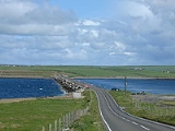
The A961 is a single-carriageway road on the eastern side of Scapa Flow
in the Orkney Islands, connecting the town of Kirkwall
on the Orkney Mainland to Burwick at the southern end of South Ronaldsay
.
The road links four islands to the mainland, crossing four causeways known collectively as the Churchill Barriers
, which were built during World War II
as naval defences to protect the natural harbour of Scapa Flow
after a successful attack by a German U-boat
.
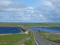 Proceeding southwards from Kirkwall, the road proceeds south to St Mary's, from where it crosses Kirk Sound on the first Churchill Barrier to the island of Lamb Holm
, site of the Italian Chapel
built by the Italian prisoners of war who built the barriers.
The second barrier carries the road to the island of Glims Holm
, from where the third barrier connects to the larger island of Burray
. From the southern shore of Burray, the fourth Churchill barrier (which has accumulated large sand dunes and no longer looks a barrier) passes onto the much larger South Ronaldsay
, the southernmost island of Orkney. The road turns south-west to the village of St Margaret's Hope
, from where it continues south to Burwick, near the southernmost point of Orkney.
Scapa Flow
right|thumb|Scapa Flow viewed from its eastern endScapa Flow is a body of water in the Orkney Islands, Scotland, United Kingdom, sheltered by the islands of Mainland, Graemsay, Burray, South Ronaldsay and Hoy. It is about...
in the Orkney Islands, connecting the town of Kirkwall
Kirkwall
Kirkwall is the biggest town and capital of Orkney, off the coast of northern mainland Scotland. The town is first mentioned in Orkneyinga saga in the year 1046 when it is recorded as the residence of Rögnvald Brusason the Earl of Orkney, who was killed by his uncle Thorfinn the Mighty...
on the Orkney Mainland to Burwick at the southern end of South Ronaldsay
South Ronaldsay
South Ronaldsay is one of the Orkney Islands off the north coast of Scotland. It is linked to the Orkney Mainland by the Churchill Barriers, running via Burray, Glimps Holm and Lamb Holm.-Geography and geology:...
.
The road links four islands to the mainland, crossing four causeways known collectively as the Churchill Barriers
Churchill Barriers
The Churchill Barriers are a series of four causeways in the Orkney Islands, Scotland, with a total length of 1.5 miles . They link the Orkney Mainland in the north to the island of South Ronaldsay via Burray and the two smaller islands of Lamb Holm and Glimps Holm.The barriers were built in the...
, which were built during World War II
World War II
World War II, or the Second World War , was a global conflict lasting from 1939 to 1945, involving most of the world's nations—including all of the great powers—eventually forming two opposing military alliances: the Allies and the Axis...
as naval defences to protect the natural harbour of Scapa Flow
Scapa Flow
right|thumb|Scapa Flow viewed from its eastern endScapa Flow is a body of water in the Orkney Islands, Scotland, United Kingdom, sheltered by the islands of Mainland, Graemsay, Burray, South Ronaldsay and Hoy. It is about...
after a successful attack by a German U-boat
U-boat
U-boat is the anglicized version of the German word U-Boot , itself an abbreviation of Unterseeboot , and refers to military submarines operated by Germany, particularly in World War I and World War II...
.
Lamb Holm
Lamb Holm is a small uninhabited island in Orkney, Scotland. The remarkable Italian Chapel, constructed during the Second World War, is the island's main attraction.-Geography:...
, site of the Italian Chapel
Italian Chapel
The Italian Chapel is a highly ornate Catholic chapel on Lamb Holm in Orkney, Scotland. It was built by Italian prisoners of war during World War II, who were housed on the previously uninhabited island while they constructed the Churchill Barriers to the east of Scapa Flow. Only the concrete...
built by the Italian prisoners of war who built the barriers.
The second barrier carries the road to the island of Glims Holm
Glims Holm
Glims Holm is a small uninhabited islet in Orkney, Scotland.-Geography:Glims Holm lies in Holm Sound, one of the eastern entrances to Scapa Flow, between Mainland, Orkney and the island of Burray, The Churchill Barriers link South Ronaldsay to the Orkney Mainland...
, from where the third barrier connects to the larger island of Burray
Burray
Burray is one of the Orkney Islands in Scotland. It lies to the east of Scapa Flow and is one of a chain of islands linked by the Churchill Barriers.-Geography and geology:...
. From the southern shore of Burray, the fourth Churchill barrier (which has accumulated large sand dunes and no longer looks a barrier) passes onto the much larger South Ronaldsay
South Ronaldsay
South Ronaldsay is one of the Orkney Islands off the north coast of Scotland. It is linked to the Orkney Mainland by the Churchill Barriers, running via Burray, Glimps Holm and Lamb Holm.-Geography and geology:...
, the southernmost island of Orkney. The road turns south-west to the village of St Margaret's Hope
St Margaret's Hope
St Margaret's Hope, known locally as The Hope , is a village in the Orkney Islands, situated off the north-east coast of Scotland. It has a population of about 550, making it Orkney's third largest settlement after Kirkwall and Stromness....
, from where it continues south to Burwick, near the southernmost point of Orkney.