

Atmospheric model
Encyclopedia
Mathematical model
A mathematical model is a description of a system using mathematical concepts and language. The process of developing a mathematical model is termed mathematical modeling. Mathematical models are used not only in the natural sciences and engineering disciplines A mathematical model is a...
constructed around the full set of primitive
Primitive equations
The primitive equations are a set of nonlinear differential equations that are used to approximate global atmospheric flow and are used in most atmospheric models...
dynamical equations
Dynamical systems theory
Dynamical systems theory is an area of applied mathematics used to describe the behavior of complex dynamical systems, usually by employing differential equations or difference equations. When differential equations are employed, the theory is called continuous dynamical systems. When difference...
which govern atmospheric motions. It can supplement these equations with parameterizations
Parametrization (climate)
Parameterization in a weather or climate model within numerical weather prediction refers to the method of replacing processes that are too small-scale or complex to be physically represented in the model by a simplified process. This can be contrasted with other processes—e.g., large-scale flow of...
for turbulent
Turbulence
In fluid dynamics, turbulence or turbulent flow is a flow regime characterized by chaotic and stochastic property changes. This includes low momentum diffusion, high momentum convection, and rapid variation of pressure and velocity in space and time...
diffusion, radiation
Radiation
In physics, radiation is a process in which energetic particles or energetic waves travel through a medium or space. There are two distinct types of radiation; ionizing and non-ionizing...
, moist processes (clouds and precipitation
Precipitation (meteorology)
In meteorology, precipitation In meteorology, precipitation In meteorology, precipitation (also known as one of the classes of hydrometeors, which are atmospheric water phenomena is any product of the condensation of atmospheric water vapor that falls under gravity. The main forms of precipitation...
), heat exchange
Heat transfer
Heat transfer is a discipline of thermal engineering that concerns the exchange of thermal energy from one physical system to another. Heat transfer is classified into various mechanisms, such as heat conduction, convection, thermal radiation, and phase-change transfer...
, soil
Soil
Soil is a natural body consisting of layers of mineral constituents of variable thicknesses, which differ from the parent materials in their morphological, physical, chemical, and mineralogical characteristics...
, vegetation, surface water, the kinematic
Kinematics
Kinematics is the branch of classical mechanics that describes the motion of bodies and systems without consideration of the forces that cause the motion....
effects of terrain
Terrain
Terrain, or land relief, is the vertical and horizontal dimension of land surface. When relief is described underwater, the term bathymetry is used...
, and convection. Most atmospheric models are numerical, i.e. they discretize equations of motion. They can predict microscale phenomena such as tornadoes and boundary layer eddies
Eddy covariance
The eddy covariance technique is a key atmospheric flux measurement technique to measure and calculate vertical turbulent fluxes within atmospheric boundary layers...
, sub-microscale turbulent flow over buildings, as well as synoptic and global flows. The horizontal domain of a model is either global, covering the entire Earth
Earth
Earth is the third planet from the Sun, and the densest and fifth-largest of the eight planets in the Solar System. It is also the largest of the Solar System's four terrestrial planets...
, or regional (limited-area), covering only part of the Earth. The different types of models run are thermotropic, barotropic
Barotropic
In meteorology, a barotropic atmosphere is one in which the pressure depends only on the density and vice versa, so that isobaric surfaces are also isopycnic surfaces . The isobaric surfaces will also be isothermal surfaces, hence the geostrophic wind is independent of height...
, hydrostatic, and nonhydrostatic. Some of the model types make assumptions about the atmosphere which lengthens the time steps used and increases computational speed.
Forecasts are computed using mathematical equations for the physics and dynamics of the atmosphere. These equations are nonlinear and are impossible to solve exactly. Therefore, numerical methods obtain approximate solutions. Different models use different solution methods. Global models often use spectral method
Spectral method
Spectral methods are a class of techniques used in applied mathematics and scientific computing to numerically solve certain Dynamical Systems, often involving the use of the Fast Fourier Transform. Where applicable, spectral methods have excellent error properties, with the so called "exponential...
s for the horizontal dimensions and finite-difference methods
Finite difference method
In mathematics, finite-difference methods are numerical methods for approximating the solutions to differential equations using finite difference equations to approximate derivatives.- Derivation from Taylor's polynomial :...
for the vertical dimension, while regional models usually use finite-difference methods in all three dimensions. For specific locations, model output statistics
Model output statistics
Model Output Statistics is an omnipresent statistical technique that forms the backbone of modern weather forecasting. The technique pioneered in the 1960s and early 1970s is used to post-process output from numerical weather forecast models...
use climate information, output from numerical weather prediction
Numerical weather prediction
Numerical weather prediction uses mathematical models of the atmosphere and oceans to predict the weather based on current weather conditions. Though first attempted in the 1920s, it was not until the advent of computer simulation in the 1950s that numerical weather predictions produced realistic...
, and current surface weather observation
Surface weather observation
Surface weather observations are the fundamental data used for safety as well as climatological reasons to forecast weather and issue warnings worldwide. They can be taken manually, by a weather observer, by computer through the use of automated weather stations, or in a hybrid scheme using...
s to develop statistical relationships which account for model bias and resolution issues.
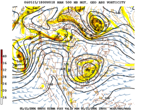
Types
The main assumption made by the thermotropic model is that while the magnitude of the thermal windThermal wind
The thermal wind is a vertical shear in the geostrophic wind caused by a horizontal temperature gradient. Its name is a misnomer, because the thermal wind is not actually a wind, but rather a wind shear.- Physical Intuition :...
may change, its direction does not change with respect to height, and thus the baroclinicity
Baroclinity
In fluid dynamics, the baroclinity of a stratified fluid is a measure of how misaligned the gradient of pressure is from the gradient of density in a fluid...
in the atmosphere can be simulated using the 500 mb and 1000 mb geopotential height
Geopotential height
Geopotential height is a vertical coordinate referenced to Earth's mean sea level — an adjustment to geometric height using the variation of gravity with latitude and elevation. Thus it can be considered a "gravity-adjusted height"...
surfaces and the average thermal wind between them.
Barotropic models assume the atmosphere is nearly barotropic
Barotropic
In meteorology, a barotropic atmosphere is one in which the pressure depends only on the density and vice versa, so that isobaric surfaces are also isopycnic surfaces . The isobaric surfaces will also be isothermal surfaces, hence the geostrophic wind is independent of height...
, which means that the direction and speed of the geostrophic wind
Geostrophic wind
The geostrophic wind is the theoretical wind that would result from an exact balance between the Coriolis effect and the pressure gradient force. This condition is called geostrophic balance. The geostrophic wind is directed parallel to isobars . This balance seldom holds exactly in nature...
are independent of height. In other words, no vertical wind shear
Wind shear
Wind shear, sometimes referred to as windshear or wind gradient, is a difference in wind speed and direction over a relatively short distance in the atmosphere...
of the geostrophic wind. It also implies that thickness contours (a proxy for temperature) are parallel to upper level height contours. In this type of atmosphere, high and low pressure areas are centers of warm and cold temperature anomalies. Warm-core highs (such as the subtropical ridge
Subtropical ridge
The subtropical ridge is a significant belt of high pressure situated around the latitudes of 30°N in the Northern Hemisphere and 30°S in the Southern Hemisphere. It is characterized by mostly calm winds, which acts to reduce air quality under its axis by causing fog overnight, and haze during...
and Bermuda-Azores high) and cold-core low
Cold-core low
A cold-core low, also known as a cold low or cold-core cyclone, is a cyclone aloft which has an associated cold pool of air residing at high altitude within the Earth's troposphere. It is a low pressure system which strengthens with height in accordance with the thermal wind relationship. These...
s have strengthening winds with height, with the reverse true for cold-core highs (shallow arctic highs) and warm-core lows (such as tropical cyclone
Tropical cyclone
A tropical cyclone is a storm system characterized by a large low-pressure center and numerous thunderstorms that produce strong winds and heavy rain. Tropical cyclones strengthen when water evaporated from the ocean is released as the saturated air rises, resulting in condensation of water vapor...
s). A barotropic model tries to solve a simplified form of atmospheric dynamics based on the assumption that the atmosphere is in geostrophic balance; that is, that the Rossby number
Rossby number
The Rossby number, named for Carl-Gustav Arvid Rossby, is a dimensionless number used in describing fluid flow. The Rossby number is the ratio of inertial to Coriolis force, terms v\cdot\nabla v\sim U^2 / L and \Omega\times v\sim U\Omega in the Navier–Stokes equations, respectively...
of the air in the atmosphere is small. If the assumption is made that the atmosphere is divergence-free, the curl of the Euler equations reduces into the barotropic vorticity equation
Barotropic vorticity equation
This Barotropic vorticity equation assumes the atmosphere is nearly barotropic, which means that the direction and speed of the geostrophic wind are independent of height. In other words, no vertical wind shear of the geostrophic wind. It also implies that thickness contours are parallel to...
. This latter equation can be solved over a single layer of the atmosphere. Since the atmosphere at a height of approximately 5.5 kilometres (3.4 mi) is mostly divergence-free, the barotropic model best approximates the state of the atmosphere at a geopotential height
Geopotential height
Geopotential height is a vertical coordinate referenced to Earth's mean sea level — an adjustment to geometric height using the variation of gravity with latitude and elevation. Thus it can be considered a "gravity-adjusted height"...
corresponding to that altitude, which corresponds to the atmosphere's 500 mb pressure surface.
Hydrostatic models filter out vertically moving acoustic wave
Acoustic wave
Acoustic waves are a type of longitudinal waves that propagate by means of adiabatic compression and decompression. Longitudinal waves are waves that have the same direction of vibration as their direction of travel. Important quantities for describing acoustic waves are sound pressure, particle...
s from the vertical momentum equation, which significantly increases the time step used within the model's run. This is known as the hydrostatic approximation
Hydrostatic equilibrium
Hydrostatic equilibrium or hydrostatic balance is the condition in fluid mechanics where a volume of a fluid is at rest or at constant velocity. This occurs when compression due to gravity is balanced by a pressure gradient force...
. Hydrostatic models use either pressure or sigma-pressure vertical coordinates. Pressure coordinates intersect topography while sigma coordinates follow the contour of the land. Its hydrostatic assumption is reasonable as long as horizontal grid resolution is not small, which is a scale where the hydrostatic assumption fails. Models which use the entire vertical momentum equation are known as nonhydrostatic. A nonhydrostatic model can be solved anelastically, meaning it solves the complete continuity equation
Continuity equation
A continuity equation in physics is a differential equation that describes the transport of a conserved quantity. Since mass, energy, momentum, electric charge and other natural quantities are conserved under their respective appropriate conditions, a variety of physical phenomena may be described...
for air, or elastically, meaning it solves the complete continuity equation for air and is fully compressible. Nonhydrostatic models use altitude or sigma altitude for their vertical coordinates. Altitude coordinates can intersect land while sigma-altitude coordinates follow the contours of the land.
History

The history of numerical weather prediction
History of numerical weather prediction
The history of numerical weather prediction considers how current weather conditions as input into mathematical models of the atmosphere and oceans to predict the weather and future sea state has changed over the years...
began in the 1920s through the efforts of Lewis Fry Richardson
Lewis Fry Richardson
Lewis Fry Richardson, FRS was an English mathematician, physicist, meteorologist, psychologist and pacifist who pioneered modern mathematical techniques of weather forecasting, and the application of similar techniques to studying the causes of wars and how to prevent them...
who utilized procedures developed by Vilhelm Bjerknes. It was not until the advent of the computer and computer simulation
Computer simulation
A computer simulation, a computer model, or a computational model is a computer program, or network of computers, that attempts to simulate an abstract model of a particular system...
that computation time was reduced to less than the forecast period itself. ENIAC
ENIAC
ENIAC was the first general-purpose electronic computer. It was a Turing-complete digital computer capable of being reprogrammed to solve a full range of computing problems....
created the first computer forecasts in 1950, and more powerful computers later increased the size of initial datasets and included more complicated versions of the equations of motion. In 1966, West Germany
West Germany
West Germany is the common English, but not official, name for the Federal Republic of Germany or FRG in the period between its creation in May 1949 to German reunification on 3 October 1990....
and the United States began producing operational forecasts based on primitive-equation
Primitive equations
The primitive equations are a set of nonlinear differential equations that are used to approximate global atmospheric flow and are used in most atmospheric models...
models, followed by the United Kingdom in 1972 and Australia in 1977. The development of global forecasting models led to the first climate models. The development of limited area (regional) models facilitated advances in forecasting the tracks of tropical cyclone
Tropical cyclone
A tropical cyclone is a storm system characterized by a large low-pressure center and numerous thunderstorms that produce strong winds and heavy rain. Tropical cyclones strengthen when water evaporated from the ocean is released as the saturated air rises, resulting in condensation of water vapor...
as well as air quality in the 1970s and 1980s.
Because the output of forecast models based on atmospheric dynamics requires corrections near ground level, model output statistics
Model output statistics
Model Output Statistics is an omnipresent statistical technique that forms the backbone of modern weather forecasting. The technique pioneered in the 1960s and early 1970s is used to post-process output from numerical weather forecast models...
(MOS) were developed in the 1970s and 1980s for individual forecast points (locations). Even with the increasing power of supercomputers, the forecast skill
Forecast skill
Skill in forecasting is a scaled representation of forecast error that relates the forecast accuracy of a particular forecast model to some reference model....
of numerical weather models only extends to about two weeks into the future, since the density and quality of observations—together with the chaotic
Chaos theory
Chaos theory is a field of study in mathematics, with applications in several disciplines including physics, economics, biology, and philosophy. Chaos theory studies the behavior of dynamical systems that are highly sensitive to initial conditions, an effect which is popularly referred to as the...
nature of the partial differential equation
Partial differential equation
In mathematics, partial differential equations are a type of differential equation, i.e., a relation involving an unknown function of several independent variables and their partial derivatives with respect to those variables...
s used to calculate the forecast—introduce errors which double every five days. The use of model ensemble forecasts since the 1990s helps to define the forecast uncertainty and extend weather forecasting farther into the future than otherwise possible.
Initialization
Atmosphere
An atmosphere is a layer of gases that may surround a material body of sufficient mass, and that is held in place by the gravity of the body. An atmosphere may be retained for a longer duration, if the gravity is high and the atmosphere's temperature is low...
is a fluid
Fluid
In physics, a fluid is a substance that continually deforms under an applied shear stress. Fluids are a subset of the phases of matter and include liquids, gases, plasmas and, to some extent, plastic solids....
. As such, the idea of numerical weather prediction is to sample the state of the fluid at a given time and use the equations of fluid dynamics
Fluid dynamics
In physics, fluid dynamics is a sub-discipline of fluid mechanics that deals with fluid flow—the natural science of fluids in motion. It has several subdisciplines itself, including aerodynamics and hydrodynamics...
and thermodynamics
Thermodynamics
Thermodynamics is a physical science that studies the effects on material bodies, and on radiation in regions of space, of transfer of heat and of work done on or by the bodies or radiation...
to estimate the state of the fluid at some time in the future. On land, terrain maps, available at resolutions down to 1 kilometre (0.621372736649807 mi) globally, are used to help model atmospheric circulations within regions of rugged topography, in order to better depict features such as downslope winds, mountain waves, and related cloudiness which affects incoming solar radiation. The main inputs from country-based weather services are surface observations from automated weather station
Weather station
A weather station is a facility, either on land or sea, with instruments and equipment for observing atmospheric conditions to provide information for weather forecasts and to study the weather and climate. The measurements taken include temperature, barometric pressure, humidity, wind speed, wind...
s at ground level over land and from weather buoys at sea. The World Meteorological Organization
World Meteorological Organization
The World Meteorological Organization is an intergovernmental organization with a membership of 189 Member States and Territories. It originated from the International Meteorological Organization , which was founded in 1873...
acts to standardize the instrumentation, observing practices and timing of these observations worldwide. Stations either report hourly in METAR
METAR
METAR is a format for reporting weather information. A METAR weather report is predominantly used by pilots in fulfillment of a part of a pre-flight weather briefing, and by meteorologists, who use aggregated METAR information to assist in weather forecasting....
reports, or every six hours in SYNOP
SYNOP
SYNOP is a numerical code used for reporting weather observations made by manned and automated weather stations. SYNOP reports are typically sent every six hours on shortwave using RTTY...
reports. Models are initialized using this observed data. The irregularly spaced observations are processed by data assimilation
Data assimilation
Applications of data assimilation arise in many fields of geosciences, perhaps most importantly in weather forecasting and hydrology. Data assimilation proceeds by analysis cycles...
and objective analysis methods, which perform quality control and obtain values at locations usable by the model's mathematical algorithms. The grid used for global models is geodesic
Geodesic grid
A geodesic grid is a technique used to model the surface of a sphere with a subdivided polyhedron, usually an icosahedron.-Introduction:...
or icosahedral
Icosahedron
In geometry, an icosahedron is a regular polyhedron with 20 identical equilateral triangular faces, 30 edges and 12 vertices. It is one of the five Platonic solids....
, spaced by latitude, longitude, and elevation. The data are then used in the model as the starting point for a forecast.
A variety of methods are used to gather observational data for use in numerical models. Sites launch radiosonde
Radiosonde
A radiosonde is a unit for use in weather balloons that measures various atmospheric parameters and transmits them to a fixed receiver. Radiosondes may operate at a radio frequency of 403 MHz or 1680 MHz and both types may be adjusted slightly higher or lower as required...
s, which rise through the troposphere
Troposphere
The troposphere is the lowest portion of Earth's atmosphere. It contains approximately 80% of the atmosphere's mass and 99% of its water vapor and aerosols....
and well into the stratosphere
Stratosphere
The stratosphere is the second major layer of Earth's atmosphere, just above the troposphere, and below the mesosphere. It is stratified in temperature, with warmer layers higher up and cooler layers farther down. This is in contrast to the troposphere near the Earth's surface, which is cooler...
. Information from weather satellite
Weather satellite
The weather satellite is a type of satellite that is primarily used to monitor the weather and climate of the Earth. Satellites can be either polar orbiting, seeing the same swath of the Earth every 12 hours, or geostationary, hovering over the same spot on Earth by orbiting over the equator while...
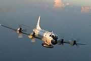
s is used where traditional data sources are not available. Commerce provides pilot reports along aircraft routes and ship reports along shipping routes. Research projects use reconnaissance aircraft
Weather reconnaissance
Weather reconnaissance is the acquisition of weather data used for research and planning. Typically the term reconnaissance refers to observing weather from the air, as opposed to the ground .- Aircraft :Balloon...
to fly in and around weather systems of interest, such as tropical cyclone
Tropical cyclone
A tropical cyclone is a storm system characterized by a large low-pressure center and numerous thunderstorms that produce strong winds and heavy rain. Tropical cyclones strengthen when water evaporated from the ocean is released as the saturated air rises, resulting in condensation of water vapor...
s. Reconnaissance aircraft are also flown over the open oceans during the cold season into systems which cause significant uncertainty in forecast guidance, or are expected to be of high impact 3–7 days into the future over the downstream continent. Sea ice began to be initialized in forecast models in 1971. Efforts to involve sea surface temperature
Sea surface temperature
Sea surface temperature is the water temperature close to the oceans surface. The exact meaning of surface varies according to the measurement method used, but it is between and below the sea surface. Air masses in the Earth's atmosphere are highly modified by sea surface temperatures within a...
in model initialization began in 1972 due to its role in modulating weather in higher latitudes of the Pacific.
Computation
Primitive equations
The primitive equations are a set of nonlinear differential equations that are used to approximate global atmospheric flow and are used in most atmospheric models...
, used to predict the future state of the atmosphere. These equations are initialized from the analysis data and rates of change are determined. These rates of change predict the state of the atmosphere a short time into the future, with each time increment known as a time step. The equations are then applied to this new atmospheric state to find new rates of change, and these new rates of change predict the atmosphere at a yet further time into the future. Time stepping is repeated until the solution reaches the desired forecast time. The length of the time step chosen within the model is related to the distance between the points on the computational grid, and is chosen to maintain numerical stability
Numerical stability
In the mathematical subfield of numerical analysis, numerical stability is a desirable property of numerical algorithms. The precise definition of stability depends on the context, but it is related to the accuracy of the algorithm....
. Time steps for global models are on the order of tens of minutes, while time steps for regional models are between one and four minutes. The global models are run at varying times into the future. The UKMET Unified model
Unified Model
The Unified Model is a Numerical Weather Prediction and climate modeling software suite originally developed by the United Kingdom Met Office, and now both used and further developed by many weather-forecasting agencies around the world...
is run six days into the future, the European Centre for Medium-Range Weather Forecasts
European Centre for Medium-Range Weather Forecasts
The European Centre for Medium-Range Weather Forecasts is an independent intergovernmental organisation supported by 19 European Member States and 15 Co-operating States...
model is run out to 10 days into the future, while the Global Forecast System
Global Forecast System
The Global Forecast System is a global numerical weather prediction computer model run by NOAA. This mathematical model is run four times a day and produces forecasts up to 16 days in advance, but with decreasing spatial and temporal resolution over time...
model run by the Environmental Modeling Center
Environmental Modeling Center
The Environmental Modeling Center , improves numerical weather, marine and climate predictions at the National Centers for Environmental Prediction , through a broad program of research in data assimilation and modeling...
is run 16 days into the future.
The equations used are nonlinear partial differential equations which are impossible to solve exactly through analytical methods, with the exception of a few idealized cases. Therefore, numerical methods obtain approximate solutions. Different models use different solution methods: some global models use spectral method
Spectral method
Spectral methods are a class of techniques used in applied mathematics and scientific computing to numerically solve certain Dynamical Systems, often involving the use of the Fast Fourier Transform. Where applicable, spectral methods have excellent error properties, with the so called "exponential...
s for the horizontal dimensions and finite difference method
Finite difference method
In mathematics, finite-difference methods are numerical methods for approximating the solutions to differential equations using finite difference equations to approximate derivatives.- Derivation from Taylor's polynomial :...
s for the vertical dimension, while regional models and other global models usually use finite-difference methods in all three dimensions. The visual output produced by a model solution is known as a prognostic chart
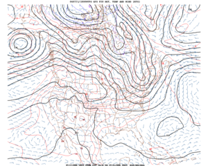
Prognostic chart
Prognostic charts are maps which display what the weather is expected to be like at a future time; in other words, a forecast map. Within the United States, manual prognostic charts generated by the National Centers for Environmental Prediction have special symbols which require interpretation...
, or prog.
Parameterization
Weather and climate model gridboxes have sides of between 5 kilometres (3.1 mi) and 300 kilometres (186.4 mi). A typical cumulus cloudCumulus cloud
Cumulus clouds are a type of cloud with noticeable vertical development and clearly defined edges. Cumulus means "heap" or "pile" in Latin. They are often described as "puffy" or "cotton-like" in appearance. Cumulus clouds may appear alone, in lines, or in clusters...
has a scale of less than 1 kilometre (0.621372736649807 mi), and would require a grid even finer than this to be represented physically by the equations of fluid motion. Therefore the processes that such clouds represent are parameterized
Parametrization
Parametrization is the process of deciding and defining the parameters necessary for a complete or relevant specification of a model or geometric object....
, by processes of various sophistication. In the earliest models, if a column of air in a model gridbox was unstable (i.e., the bottom warmer than the top) then it would be overturned, and the air in that vertical column mixed. More sophisticated schemes add enhancements, recognizing that only some portions of the box might convect
Convection
Convection is the movement of molecules within fluids and rheids. It cannot take place in solids, since neither bulk current flows nor significant diffusion can take place in solids....
and that entrainment and other processes occur. Weather models that have gridboxes with sides between 5 kilometres (3.1 mi) and 25 kilometres (15.5 mi) can explicitly represent convective clouds, although they still need to parameterize cloud microphysics. The formation of large-scale (stratus
Stratus cloud
A stratus cloud is a cloud belonging to a class characterized by horizontal layering with a uniform base, as opposed to convective clouds that are as tall or taller than wide . More specifically, the term stratus is used to describe flat, hazy, featureless clouds of low altitude varying in color...
-type) clouds is more physically based, they form when the relative humidity
Relative humidity
Relative humidity is a term used to describe the amount of water vapor in a mixture of air and water vapor. It is defined as the partial pressure of water vapor in the air-water mixture, given as a percentage of the saturated vapor pressure under those conditions...
reaches some prescribed value. Still, sub grid scale processes need to be taken into account. Rather than assuming that clouds form at 100% relative humidity, the cloud fraction
Cloud fraction
Cloud fraction is the percentage of each pixel in satellite imagery or each gridbox in a weather or climate model that is covered with clouds. A cloud fraction of one means the pixel is completely covered with clouds, while a cloud fraction of zero represents a totally cloud free pixel....
can be related to a critical relative humidity of 70% for stratus-type clouds, and at or above 80% for cumuliform clouds, reflecting the sub grid scale variation that would occur in the real world.
The amount of solar radiation reaching ground level in rugged terrain, or due to variable cloudiness, is parameterized as this process occurs on the molecular scale. Also, the grid size of the models is large when compared to the actual size and roughness of clouds and topography. Sun angle as well as the impact of multiple cloud layers is taken into account. Soil type, vegetation type, and soil moisture all determine how much radiation goes into warming and how much moisture is drawn up into the adjacent atmosphere. Thus, they are important to parameterize.
Domains
The horizontal domain of a model is either global, covering the entire Earth, or regional, covering only part of the Earth. Regional models also are known as limited-area models, or LAMs. Regional models use finer grid spacing to resolve explicitly smaller-scale meteorological phenomena, since their smaller domain decreases computational demands. Regional models use a compatible global model for initial conditions of the edge of their domain. Uncertainty and errors within LAMs are introduced by the global model used for the boundary conditions of the edge of the regional model, as well as within the creation of the boundary conditions for the LAMs itself.The vertical coordinate is handled in various ways. Some models, such as Richardson's 1922 model, use geometric height (
 ) as the vertical coordinate. Later models substituted the geometric
  coordinate with a pressure coordinate system, in which the geopotential height
Geopotential height
Geopotential height is a vertical coordinate referenced to Earth's mean sea level — an adjustment to geometric height using the variation of gravity with latitude and elevation. Thus it can be considered a "gravity-adjusted height"...
s of constant-pressure surfaces become dependent variables, greatly simplifying the primitive equations. This follows since pressure decreases with height through the Earth's atmosphere
Earth's atmosphere
The atmosphere of Earth is a layer of gases surrounding the planet Earth that is retained by Earth's gravity. The atmosphere protects life on Earth by absorbing ultraviolet solar radiation, warming the surface through heat retention , and reducing temperature extremes between day and night...
. The first model used for operational forecasts, the single-layer barotropic model, used a single pressure coordinate at the 500 millibars (14.8 inHg) level, and thus was essentially two-dimensional. High-resolution models—also called mesoscale models—such as the Weather Research and Forecasting model
Weather Research and Forecasting model
The Weather Research and Forecasting model, , is a specific computer program with a dual use for forecasting and research. It was created through a partnership that includes the National Oceanic and Atmospheric Administration , the National Center for Atmospheric Research , and more than 150 other...
tend to use normalized pressure coordinates referred to as sigma coordinates. This coordinate system receives that name since the independent variable
Independent variable
The terms "dependent variable" and "independent variable" are used in similar but subtly different ways in mathematics and statistics as part of the standard terminology in those subjects...
 is used to represent a pressure level (
 ) scaled
Nondimensionalization
Nondimensionalization is the partial or full removal of units from an equation involving physical quantities by a suitable substitution of variables. This technique can simplify and parameterize problems where measured units are involved. It is closely related to dimensional analysis...
with the surface pressure (
 ) and in some cases the pressure at the top of the domain (
 ).
).Global versions
Some of the better known global numerical models are:- GFS Global Forecast SystemGlobal Forecast SystemThe Global Forecast System is a global numerical weather prediction computer model run by NOAA. This mathematical model is run four times a day and produces forecasts up to 16 days in advance, but with decreasing spatial and temporal resolution over time...
(previously AVN) – developed by NOAA - NOGAPS – developed by the US Navy to compare with the GFS
- GEM Global Environmental Multiscale ModelGlobal Environmental Multiscale ModelThe Global Environmental Multiscale Model is an integrated forecasting and data assimilation system developed in the Recherche en Prévision Numérique , Meteorological Research Branch , and the Canadian Meteorological Centre ....
– developed by the Meteorological Service of CanadaMeteorological Service of CanadaThe Meteorological Service of Canada , also known as "The Canadian Weather Service", is a division of Environment Canada, which primarily provides public meteorological information and weather forecasts and warnings of severe weather and other environmental hazards...
(MSC) - IFS developed by the European Centre for Medium-Range Weather ForecastsEuropean Centre for Medium-Range Weather ForecastsThe European Centre for Medium-Range Weather Forecasts is an independent intergovernmental organisation supported by 19 European Member States and 15 Co-operating States...
- UM Unified ModelUnified ModelThe Unified Model is a Numerical Weather Prediction and climate modeling software suite originally developed by the United Kingdom Met Office, and now both used and further developed by many weather-forecasting agencies around the world...
developed by the UKUnited KingdomThe United Kingdom of Great Britain and Northern IrelandIn the United Kingdom and Dependencies, other languages have been officially recognised as legitimate autochthonous languages under the European Charter for Regional or Minority Languages...
Met OfficeMet OfficeThe Met Office , is the United Kingdom's national weather service, and a trading fund of the Department for Business, Innovation and Skills...
, but is hand-corrected by professional forecasters - GME developed by the German Weather ServiceGerman Weather ServiceThe Deutscher Wetterdienst, , commonly abbreviated as DWD, , residing in Offenbach am Main, Germany, is a scientific agency that monitors weather and meteorological conditions over Germany and offers weather services for the general public as well as specific services for e.g. nautical, aviational...
, DWD, NWP Global model of DWD - ARPEGE developed by the French Weather Service, Météo-FranceMétéo-FranceMétéo-France is the French national meteorological service.The organisation was established by decree in June 1993 and is a department of the Ministry of Transportation. It is headquartered in Paris but many domestic operations have been decentralised to Toulouse...
- IGCM Intermediate General Circulation ModelIntermediate General Circulation ModelThe Reading Intermediate General Circulation Model , is a simplified or "intermediate" Global climate model, which is developed by members of the at the University of Reading, and by members of the of the Department of Atmospheric and Oceanic Sciences at McGill UniversityThe IGCM is a fast GCM...
Regional versions
Some of the better known regional numerical models are:- WRF The Weather Research and Forecasting modelWeather Research and Forecasting modelThe Weather Research and Forecasting model, , is a specific computer program with a dual use for forecasting and research. It was created through a partnership that includes the National Oceanic and Atmospheric Administration , the National Center for Atmospheric Research , and more than 150 other...
was developed cooperatively by NCEP, NCAR, and the meteorological research community. WRF has several configurations, including: - WRF-NMM The WRF Nonhydrostatic Mesoscale Model is the primary short-term weather forecast model for the U.S., replacing the Eta model.
- AR-WRF Advanced Research WRF developed primarily at the U.S. National Center for Atmospheric ResearchNational Center for Atmospheric ResearchThe National Center for Atmospheric Research has multiple facilities, including the I. M. Pei-designed Mesa Laboratory headquarters in Boulder, Colorado. NCAR is managed by the nonprofit University Corporation for Atmospheric Research and sponsored by the National Science Foundation...
(NCAR) - NAMNorth American Mesoscale ModelThe North American Mesoscale Model , refers to a numerical weather prediction model run by National Centers for Environmental Prediction for short-term weather forecasting. Currently, the Weather Research and Forecasting Non-hydrostatic Mesoscale Model model is run as the NAM, thus, three names ...
The term North American Mesoscale model refers to whatever regional model NCEPNational Centers for Environmental PredictionThe United States National Centers for Environmental Prediction delivers national and global weather, water, climate and space weather guidance, forecasts, warnings and analyses to its Partners and External User Communities...
operates over the North American domain. NCEP began using this designation system in January 2005. Between January 2005 and May 2006 the Eta model used this designation. Beginning in May 2006, NCEP began to use the WRF-NMM as the operational NAM. - RAMS the Regional Atmospheric Modeling System developed at Colorado State University for numerical simulations of atmospheric meteorology and other environmental phenomena on scales from meters to hundreds of kilometers - now supported in the public domain
- MM5 The Fifth Generation Penn State/NCAR Mesoscale Model
- ARPS the Advanced Region Prediction System developed at the University of Oklahoma is a comprehensive multi-scale nonhydrostatic simulation and prediction system that can be used for regional-scale weather prediction up to the tornado-scale simulation and prediction. Advanced radar data assimilation for thunderstorm prediction is a key part of the system..
- HIRLAMHIRLAMHIRLAM, the High Resolution Limited Area Model, is a Numerical Weather Prediction forecast system developed by the international HIRLAM programme.-Consortium:...
High Resolution Limited Area Model - GEM-LAM Global Environmental Multiscale Limited Area Model, the high resolution (2.5 km) GEM by the Meteorological Service of CanadaMeteorological Service of CanadaThe Meteorological Service of Canada , also known as "The Canadian Weather Service", is a division of Environment Canada, which primarily provides public meteorological information and weather forecasts and warnings of severe weather and other environmental hazards...
(MSC) - ALADIN The high-resolution limited-area hydrostatic and non-hydrostatic model developed and operated by several European and North African countries under the leadership of Météo-France
- COSMO The COSMO Model, formerly known as LM, aLMo or LAMI, is a limited-area non-hydrostatic model developed within the framework of the Consortium for Small-Scale Modelling (Germany, Switzerland, Italy, Greece, Poland, Romania, and Russia).
- COSMO The COSMO Model (formerly known as LM, aLMo or LAMI) is a limited-area non-hydrostatic model for operational numerical weather prediction, regional climate modelling, environmental prediction (aerosols, pollen and atmospheric chemistry) and research (idealised case studies). A first NWP version was originally developed by the German Weather Service. It is now further developed by the Consortium for Small-Scale Modelling, the Climate Limited-area Modelling (CLM)-Community, and other research institutes.[1]
Model output statistics
Because forecast models based upon the equations for atmospheric dynamics do not perfectly determine weather conditions near the ground, statistical corrections were developed to attempt to resolve this problem. Statistical models were created based upon the three-dimensional fields produced by numerical weather models, surface observations, and the climatological conditions for specific locations. These statistical models are collectively referred to as model output statisticsModel output statistics
Model Output Statistics is an omnipresent statistical technique that forms the backbone of modern weather forecasting. The technique pioneered in the 1960s and early 1970s is used to post-process output from numerical weather forecast models...
(MOS), and were developed by the National Weather Service
National Weather Service
The National Weather Service , once known as the Weather Bureau, is one of the six scientific agencies that make up the National Oceanic and Atmospheric Administration of the United States government...
for their suite of weather forecasting models. The United States Air Force
United States Air Force
The United States Air Force is the aerial warfare service branch of the United States Armed Forces and one of the American uniformed services. Initially part of the United States Army, the USAF was formed as a separate branch of the military on September 18, 1947 under the National Security Act of...
developed its own set of MOS based upon their dynamical weather model by 1983.
Model output statistics differ from the perfect prog technique, which assumes that the output of numerical weather prediction guidance is perfect. MOS can correct for local effects that cannot be resolved by the model due to insufficient grid resolution, as well as model biases. Forecast parameters within MOS include maximum and minimum temperatures, percentage chance of rain within a several hour period, precipitation amount expected, chance that the precipitation will be frozen in nature, chance for thunderstorms, cloudiness, and surface winds.
Climate modeling
In 1956, Norman Phillips developed a mathematical model which could realistically depict monthly and seasonal patterns in the troposphere; this became the first successful climate modelClimate model
Climate models use quantitative methods to simulate the interactions of the atmosphere, oceans, land surface, and ice. They are used for a variety of purposes from study of the dynamics of the climate system to projections of future climate...
. Following Phillips's work, several groups began working to create general circulation models. The first general circulation climate model that combined both oceanic and atmospheric processes was developed in the late 1960s at the NOAA Geophysical Fluid Dynamics Laboratory
Geophysical Fluid Dynamics Laboratory
The Geophysical Fluid Dynamics Laboratory is a laboratory in the National Oceanic and Atmospheric Administration /Office of Oceanic and Atmospheric Research . The current director is Dr. V...
. By the early 1980s, the United States' National Center for Atmospheric Research
National Center for Atmospheric Research
The National Center for Atmospheric Research has multiple facilities, including the I. M. Pei-designed Mesa Laboratory headquarters in Boulder, Colorado. NCAR is managed by the nonprofit University Corporation for Atmospheric Research and sponsored by the National Science Foundation...
had developed the Community Atmosphere Model; this model has been continuously refined into the 2000s. In 1986, efforts began to initialize and model soil and vegetation types, which led to more realistic forecasts. Coupled ocean-atmosphere climate models such as the Hadley Centre for Climate Prediction and Research
Hadley Centre for Climate Prediction and Research
The Met Office Hadley Centre for Climate Change — named in honour of George Hadley — is part of, and based at the headquarters of the Met Office in Exeter...
's HadCM3
HadCM3
HadCM3 is a coupled atmosphere-ocean general circulation model developed at the Hadley Centre in the United Kingdom...
model are currently being used as inputs for climate change
Climate change
Climate change is a significant and lasting change in the statistical distribution of weather patterns over periods ranging from decades to millions of years. It may be a change in average weather conditions or the distribution of events around that average...
studies.
Limited area modeling
Air quality forecasts depend on Atmospheric models to provide fluid flow information for tracking the movement of a pollutant. The Urban Airshed Model, a regional forecast model for the effects of air pollution
Air pollution
Air pollution is the introduction of chemicals, particulate matter, or biological materials that cause harm or discomfort to humans or other living organisms, or cause damage to the natural environment or built environment, into the atmosphere....
and acid rain
Acid rain
Acid rain is a rain or any other form of precipitation that is unusually acidic, meaning that it possesses elevated levels of hydrogen ions . It can have harmful effects on plants, aquatic animals, and infrastructure. Acid rain is caused by emissions of carbon dioxide, sulfur dioxide and nitrogen...
, was developed by a private company in the USA in 1970. Development of this model was taken over by the Environmental Protection Agency and improved in the mid to late 1970s using results from a regional air pollution study. While developed in California
California
California is a state located on the West Coast of the United States. It is by far the most populous U.S. state, and the third-largest by land area...
, this model was later used in other areas of North America
North America
North America is a continent wholly within the Northern Hemisphere and almost wholly within the Western Hemisphere. It is also considered a northern subcontinent of the Americas...
, Europe
Europe
Europe is, by convention, one of the world's seven continents. Comprising the westernmost peninsula of Eurasia, Europe is generally 'divided' from Asia to its east by the watershed divides of the Ural and Caucasus Mountains, the Ural River, the Caspian and Black Seas, and the waterways connecting...
and Asia
Asia
Asia is the world's largest and most populous continent, located primarily in the eastern and northern hemispheres. It covers 8.7% of the Earth's total surface area and with approximately 3.879 billion people, it hosts 60% of the world's current human population...
during the 1980s.
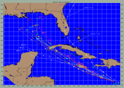
In 1978, the first hurricane-tracking model based on atmospheric dynamics – the movable fine-mesh (MFM) model – began operating. Within the field of tropical cyclone track forecasting
Tropical cyclone track forecasting
Tropical cyclone track forecasting involves predicting where a tropical cyclone is going to track over the next five days, every 6 to 12 hours. The history of tropical cyclone track forecasting has evolved from a single station approach to a comprehensive approach which uses a variety of...
, despite the ever-improving dynamical model guidance which occurred with increased computational power, it was not until the decade of the 1980s when numerical weather prediction showed skill
Forecast skill
Skill in forecasting is a scaled representation of forecast error that relates the forecast accuracy of a particular forecast model to some reference model....
, and until the 1990s when it consistently outperformed statistical
Statistical model
A statistical model is a formalization of relationships between variables in the form of mathematical equations. A statistical model describes how one or more random variables are related to one or more random variables. The model is statistical as the variables are not deterministically but...
or simple dynamical models. However, predictions of the intensity of a tropical cyclone based on numerical weather prediction continues to be a challenge, since statical methods continue to show higher skill over dynamical guidance.
See also
- Climate modelClimate modelClimate models use quantitative methods to simulate the interactions of the atmosphere, oceans, land surface, and ice. They are used for a variety of purposes from study of the dynamics of the climate system to projections of future climate...
- Numerical weather predictionNumerical weather predictionNumerical weather prediction uses mathematical models of the atmosphere and oceans to predict the weather based on current weather conditions. Though first attempted in the 1920s, it was not until the advent of computer simulation in the 1950s that numerical weather predictions produced realistic...
- Upper Atmospheric ModelsUpper Atmospheric ModelsMost climate models simulate a region of the Earth's atmosphere from the surface to the stratopause. There also exist numerical models which simulate the wind, temperature and composition of the Earth's tenuous upper atmosphere, from the mesosphere to the exosphere, including the ionosphere...