

Tropical cyclone track forecasting
Encyclopedia
Tropical cyclone
A tropical cyclone is a storm system characterized by a large low-pressure center and numerous thunderstorms that produce strong winds and heavy rain. Tropical cyclones strengthen when water evaporated from the ocean is released as the saturated air rises, resulting in condensation of water vapor...
is going to track over the next five days, every 6 to 12 hours. The history of tropical cyclone track forecasting has evolved from a single station approach to a comprehensive approach which uses a variety of meteorological tools and methods to make predictions. The weather of a particular location can show signs of the approaching tropical cyclone, such as increasing swell, increasing cloudiness, falling barometric pressure, increasing tides, squall
Squall
A squall is a sudden, sharp increase in wind speed which is usually associated with active weather, such as rain showers, thunderstorms, or heavy snow. Squalls refer to an increase in the sustained winds over a short time interval, as there may be higher gusts during a squall event...
s, and heavy rainfall.
The forces that affect tropical cyclone steering are the higher latitude westerlies, the subtropical ridge
Subtropical ridge
The subtropical ridge is a significant belt of high pressure situated around the latitudes of 30°N in the Northern Hemisphere and 30°S in the Southern Hemisphere. It is characterized by mostly calm winds, which acts to reduce air quality under its axis by causing fog overnight, and haze during...
, and the beta effect caused by changes of the coriolis force within fluids such as the atmosphere
Atmosphere
An atmosphere is a layer of gases that may surround a material body of sufficient mass, and that is held in place by the gravity of the body. An atmosphere may be retained for a longer duration, if the gravity is high and the atmosphere's temperature is low...
. Accurate track predictions depend on determining the position and strength of high
High pressure area
A high-pressure area is a region where the atmospheric pressure at the surface of the planet is greater than its surrounding environment. Winds within high-pressure areas flow outward due to the higher density air near their center and friction with land...
and low pressure area
Low pressure area
A low-pressure area, or "low", is a region where the atmospheric pressure at sea level is below that of surrounding locations. Low-pressure systems form under areas of wind divergence which occur in upper levels of the troposphere. The formation process of a low-pressure area is known as...
s, and predicting how those areas will migrate during the life of a tropical system. Computer forecast models are used to help determine this motion as far out as five to seven days in the future.
History
The methods through which tropical cyclones are forecast have changed with the passage of time. The first known forecasts in the Western Hemisphere were made by Lt. Col. William Reed of the Corps of Royal Engineers at Barbados in 1847. Reed mostly utilized barometric pressure measurements as the basis of his forecasts. Benito Vines introduced a forecast and warning system based on cloud cover changes in HavanaHavana
Havana is the capital city, province, major port, and leading commercial centre of Cuba. The city proper has a population of 2.1 million inhabitants, and it spans a total of — making it the largest city in the Caribbean region, and the most populous...
during the 1870s. Before the early 1900s, though, most forecasts were done by direct observations at weather stations, which were then relayed to forecast centers via telegraph. It was not until the advent of radio
Radio
Radio is the transmission of signals through free space by modulation of electromagnetic waves with frequencies below those of visible light. Electromagnetic radiation travels by means of oscillating electromagnetic fields that pass through the air and the vacuum of space...
in the early twentieth century that observations from ships at sea were available to forecasters. The 1930s saw the usage of radiosondes in tropical cyclone forecasting. The next decade saw the advent of aircraft-based reconnaissance by the military, starting with the first dedicated flight into a hurricane in 1943, and the establishment of the Hurricane Hunters
Hurricane Hunters
The Hurricane Hunters are aircraft that fly into tropical cyclones in the North Atlantic Ocean and Northeastern Pacific Ocean for the specific purpose of directly measuring weather data in and around those storms. In the United States, the Air Force, Navy, and NOAA units have all participated in...
in 1944. In the 1950s, coastal weather radar
Weather radar
Weather radar, also called weather surveillance radar and Doppler weather radar, is a type of radar used to locate precipitation, calculate its motion, estimate its type . Modern weather radars are mostly pulse-Doppler radars, capable of detecting the motion of rain droplets in addition to the...
s began to be used in the United States, and research reconnaissance flights by the precursor of the Hurricane Research Division
Atlantic Oceanographic and Meteorological Laboratory
The Atlantic Oceanographic and Meteorological Laboratory , a federal research laboratory, is part of National Oceanic and Atmospheric Administration's Office of Oceanic and Atmospheric Research , located in Miami, Florida...
began in 1954.
The launch of the first weather satellite, TIROS-I, in 1960, introduced new techniques to tropical cyclone forecasting that remain important to the present day. In the 1970s, buoys were introduced to improve the resolution of surface measurements, which until that point, were not available at all over sea surfaces.
Single station forecasting of a tropical cyclone passage
Ocean Swell
Ocean Swell was a British Thoroughbred racehorse and sire. In a career that lasted from 1943 to 1945 he ran fifteen times and won six races. As a three-year-old 1944 he won the New Derby, a wartime substitute for the Epsom Derby run at Newmarket...
of 1 metres (3.3 ft) in height will roll in about every 10 seconds, moving towards the coast from the direction of the tropical cyclone's location. The ocean swell will slowly increase in height and frequency the closer a tropical cyclone gets to land. Two days in advance of the center's passage, winds go calm as the tropical cyclone interrupts the environmental wind flow. Within 36 hours of the center passage, the pressure begins to fall and a veil of white cirrus clouds approaches from the cyclone
Cyclone
In meteorology, a cyclone is an area of closed, circular fluid motion rotating in the same direction as the Earth. This is usually characterized by inward spiraling winds that rotate anticlockwise in the Northern Hemisphere and clockwise in the Southern Hemisphere of the Earth. Most large-scale...
's direction. Within 24 hours of the closest approach to the center, low clouds begin to move in, also known as the bar
Bar (tropical cyclone)
The bar of a mature tropical cyclone is a very dark gray-black layer of cloud appearing near the horizon as seen from an observer preceding the approach of the storm, and is composed of dense stratocumulus clouds. Cumulus and cumulonimbus clouds bearing precipitation follow immediately after the...
of a tropical cyclone, as the barometric pressure begins to fall more rapidly and the winds begin to increase. Within 18 hours of the center's approach, squall
Squall
A squall is a sudden, sharp increase in wind speed which is usually associated with active weather, such as rain showers, thunderstorms, or heavy snow. Squalls refer to an increase in the sustained winds over a short time interval, as there may be higher gusts during a squall event...
y weather is common, with sudden increases in wind accompanied by rain showers or thunderstorms. Winds increase within 12 hours of the center's approach, occasionally reaching hurricane force. The ocean's surface becomes whipped with foam. Small items begin flying in the wind. Within 6 hours of the center's arrival, rain becomes continuous and the storm surge
Storm surge
A storm surge is an offshore rise of water associated with a low pressure weather system, typically tropical cyclones and strong extratropical cyclones. Storm surges are caused primarily by high winds pushing on the ocean's surface. The wind causes the water to pile up higher than the ordinary sea...
begins to come inland. Within an hour of the center, the rain becomes very heavy and the highest winds within the tropical cyclone are experienced. When the center arrives with a strong tropical cyclone, weather conditions improve and the sun becomes visible as the eye
Eye (cyclone)
The eye is a region of mostly calm weather found at the center of strong tropical cyclones. The eye of a storm is a roughly circular area and typically 30–65 km in diameter. It is surrounded by the eyewall, a ring of towering thunderstorms where the second most severe weather of a cyclone...
moves overhead. At this point, the pressure ceases to drop as the lowest pressure within the storm's center is reached. This is also when the peak depth of the storm surge occurs. Once the system departs, winds reverse and, along with the rain, suddenly increase. The storm surge retreats as the pressure suddenly rises in the wake of its center. One day after the center's passage, the low overcast is replaced with a higher overcast, and the rain becomes intermittent. By 36 hours after the center's passage, the high overcast breaks and the pressure begins to level off.
Basics
The large scale synoptic scale flow determines 70 to 90 percent of a tropical cyclone's motion. The deep-layered mean flow through the troposphereTroposphere
The troposphere is the lowest portion of Earth's atmosphere. It contains approximately 80% of the atmosphere's mass and 99% of its water vapor and aerosols....
is considered to be the best tool in determining track direction and speed. If storms experience significant vertical wind shear
Wind shear
Wind shear, sometimes referred to as windshear or wind gradient, is a difference in wind speed and direction over a relatively short distance in the atmosphere...
, use of a lower level wind such as the 700 hPa pressure level (at a height of 3000 metres (9,842.5 ft) above sea level) will work out as a better predictor. Knowledge of the beta effect can be used to steer a tropical cyclone, since it leads to a more northwest heading for tropical cyclones in the Northern Hemisphere due to differences in the coriolis force around the cyclone. For example, the beta effect will allow a tropical cyclone to track poleward and slightly to the right of the deep layer steering flow while the system lies the south of the subtropical ridge. Northwest moving storms move quicker and left, while northeast moving storms move slower and left. The larger the cyclone, the larger the impact of the beta effect is likely to be.
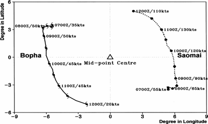
Fujiwhara effect
When two or more tropical cyclones are in proximity to one another, they begin to rotate cyclonically around the midpoint between their circulation centers. In the northern hemisphere, this is in a counterclockwise direction, and in the southern hemisphere, a clockwise direction. Usually, the tropical cyclones need to be within 1450 kilometres (901 mi) of each other for this effect to take place. It is a more common phenomenon in the northern Pacific ocean than elsewhere, due to the higher frequency of tropical cyclone activity which occurs in that region.Trochoidal motions
Small wobbles in a tropical cyclone's track can occur when the convection is distributed unevenly within its circulation. This can be due to changes in vertical wind shear or inner core structure. Because of this effect, forecasters use a longer term (6 to 24 hours) motion to help forecast tropical cyclones, which acts to smooth out such wobbles.Forecast models
High-speed computers and sophisticated simulation software allow meteorologists to run computer models
Tropical cyclone prediction model
A tropical cyclone forecast model is a computer program that uses meteorological data to forecast aspects of the future state of tropical cyclones. There are three types of models: statistical, dynamical, or combined statistical-dynamic...
that forecast tropical cyclone tracks based on the future position and strength of high- and low-pressure systems. Combining forecast models with increased understanding of the forces that act on tropical cyclones, and a wealth of data from Earth-orbiting satellites and other sensors, scientists have increased the accuracy of track forecasts over recent decades. The addition of dropwindsonde
Dropsonde
A dropsonde is a weather reconnaissance device created by the National Center for Atmospheric Research , designed to be dropped from an aircraft at altitude to more accurately measure tropical storm conditions as the device falls to the surface...
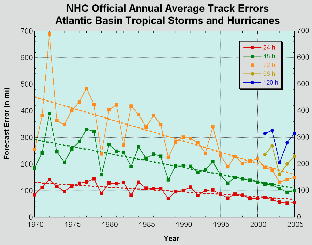
missions around tropical cyclones in what are known as synoptic flow missions in the Atlantic Basin decreased track error by 15-20 percent. Using a consensus of forecast models, as well as ensemble members of the various models, can help reduce forecast error. However, regardless how small the average error becomes, large errors within the guidance are still possible. An accurate track forecast is important, because if the track forecast is incorrect, forecasts for intensity, rainfall, storm surge, and tornado threat will also be incorrect.
Length of forecast period
Hydrometeorological Prediction Center
The Hydrometeorological Prediction Center is one of nine service centers under the umbrella of the National Centers for Environmental Prediction , a part of the National Weather Service, which in turn is part of the National Oceanic and Atmospheric Administration of the U.S. government...
and the National Hurricane Center
National Hurricane Center
The National Hurricane Center , located at Florida International University in Miami, Florida, is the division of the National Weather Service responsible for tracking and predicting weather systems within the tropics between the Prime Meridian and the 140th meridian west poleward to the 30th...
to coordinate tropical cyclone placement on the medium range pressure forecasts 6 and 7 days into the future for the northeast Pacific and Atlantic basins. Every so often, even at this time range, successful predictions can be made.
See also
- Tropical cycloneTropical cycloneA tropical cyclone is a storm system characterized by a large low-pressure center and numerous thunderstorms that produce strong winds and heavy rain. Tropical cyclones strengthen when water evaporated from the ocean is released as the saturated air rises, resulting in condensation of water vapor...
- Tropical cyclone forecastingTropical cyclone forecastingTropical cyclone forecasting is the science and art of forecasting where a tropical cyclone's center, and its effects, are expected to be at some point in the future. There are several elements to tropical cyclone forecasting: track forecasting, intensity forecasting, rainfall forecasting, storm...
- Hebert BoxHebert boxAn Hebert Box is one of two regions of the tropical Atlantic Ocean that are useful as predictors of hurricanes that will strike South Florida, USA...