

Areography
Encyclopedia
Mars
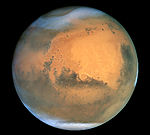
Mars is the fourth planet from the Sun in the Solar System. The planet is named after the Roman god of war, Mars. It is often described as the "Red Planet", as the iron oxide prevalent on its surface gives it a reddish appearance...
. Martian geography is mainly focused on what is called physical geography
Physical geography
Physical geography is one of the two major subfields of geography. Physical geography is that branch of natural science which deals with the study of processes and patterns in the natural environment like the atmosphere, biosphere and geosphere, as opposed to the cultural or built environment, the...
on Earth; that is the distribution of physical features across Mars and their cartographic
Cartography
Cartography is the study and practice of making maps. Combining science, aesthetics, and technique, cartography builds on the premise that reality can be modeled in ways that communicate spatial information effectively.The fundamental problems of traditional cartography are to:*Set the map's...
representations.
History
Opposition (astronomy)
In positional astronomy, two celestial bodies are said to be in opposition when they are on opposite sides of the sky, viewed from a given place . In particular, two planets are in opposition to each other when their ecliptic longitudes differ by 180°.The astronomical symbol for opposition is ☍...
of Mars, when the planet is closest to Earth and hence is most easily visible, which occur every couple of years. Even more notable are the perihelic oppositions of Mars which occur approximately every 16 years, and are distinguished because Mars is close to perihelion
Apsis
An apsis , plural apsides , is the point of greatest or least distance of a body from one of the foci of its elliptical orbit. In modern celestial mechanics this focus is also the center of attraction, which is usually the center of mass of the system...
making it even closer to Earth.
In September 1877, (a perihelic opposition of Mars occurred on September 5), Italian
Italy
Italy , officially the Italian Republic languages]] under the European Charter for Regional or Minority Languages. In each of these, Italy's official name is as follows:;;;;;;;;), is a unitary parliamentary republic in South-Central Europe. To the north it borders France, Switzerland, Austria and...
astronomer Giovanni Schiaparelli
Giovanni Schiaparelli
Giovanni Virginio Schiaparelli was an Italian astronomer and science historian. He studied at the University of Turin and Berlin Observatory. In 1859-1860 he worked in Pulkovo Observatory and then worked for over forty years at Brera Observatory...
published the first detailed map of Mars
Mars
Mars is the fourth planet from the Sun in the Solar System. The planet is named after the Roman god of war, Mars. It is often described as the "Red Planet", as the iron oxide prevalent on its surface gives it a reddish appearance...
. These maps notably contained features he called canali ("channels"), that were later shown to be an optical illusion
Optical illusion
An optical illusion is characterized by visually perceived images that differ from objective reality. The information gathered by the eye is processed in the brain to give a perception that does not tally with a physical measurement of the stimulus source...
. These canali were supposedly long straight lines on the surface of Mars to which he gave names of famous rivers on Earth. His term was popularly mistranslated as canals, and so started the Martian canal controversy.
Following these observations, it was a long held belief that Mars contained vast seas and vegetation. It was not until spacecraft
Spacecraft
A spacecraft or spaceship is a craft or machine designed for spaceflight. Spacecraft are used for a variety of purposes, including communications, earth observation, meteorology, navigation, planetary exploration and transportation of humans and cargo....
visited the planet during NASA
NASA
The National Aeronautics and Space Administration is the agency of the United States government that is responsible for the nation's civilian space program and for aeronautics and aerospace research...
's Mariner missions
Mariner program
The Mariner program was a program conducted by the American space agency NASA that launched a series of robotic interplanetary probes designed to investigate Mars, Venus and Mercury from 1963 to 1973...
in the 1960s that these myths were dispelled. Some maps of Mars were made using the data from these missions, but it wasn't until the Mars Global Surveyor
Mars Global Surveyor
The Mars Global Surveyor was a US spacecraft developed by NASA's Jet Propulsion Laboratory and launched November 1996. It began the United States's return to Mars after a 10-year absence. It completed its primary mission in January 2001 and was in its third extended mission phase when, on 2...
mission, launched in 1996 and ending in late 2006, that complete, extremely detailed maps were obtained. These maps are now available online at http://www.google.com/mars/
Interactive map of Mars
The following map has embedded links, click on the features and you will be taken to the corresponding article pages. NorthNorth
North is a noun, adjective, or adverb indicating direction or geography.North is one of the four cardinal directions or compass points. It is the opposite of south and is perpendicular to east and west.By convention, the top side of a map is north....
is at the top.
Topography
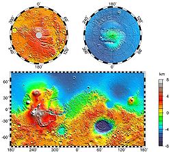
Martian dichotomy
The most conspicuous feature of Martian surface geology is a sharp contrast, known as the Martian dichotomy, between the rugged southern highlands and the relatively smooth northern basins. The two hemispheres differ in elevation by 1 to 3 km...
of Martian topography is striking: northern plains flattened by lava flows contrast with the southern highlands, pitted and cratered by ancient impacts. The surface of Mars as seen from Earth is consequently divided into two kinds of areas, with differing albedo
Albedo
Albedo , or reflection coefficient, is the diffuse reflectivity or reflecting power of a surface. It is defined as the ratio of reflected radiation from the surface to incident radiation upon it...
. The paler plains covered with dust and sand rich in reddish iron oxides were once thought of as Martian 'continents' and given names like Arabia Terra
Arabia Terra
Arabia Terra is a large upland region in the north of Mars in that lies mostly in the Arabia quadrangle. It is densely cratered and heavily eroded. This battered topography indicates great age, and Arabia Terra is presumed to be one of the oldest terrains on the planet...
(land of Arabia) or Amazonis Planitia
Amazonis Planitia
Amazonis Planitia is one of the smoothest plains on Mars. It is located between the Tharsis and Elysium volcanic provinces to the west of Olympus Mons in the Valles Marineris region of the Memnonia quadrangle, centered at...
(Amazonian plain). The dark features were thought to be seas, hence their names Mare Erythraeum
Mare Erythraeum
Mare Erythraeum is a very large dark dusky region of Mars that can be viewed by even a small telescope. The name comes from the Latin for the Erythraean Sea, because it was originally thought to be a large sea of liquid water. It was included in Percival Lowell's 1895 map of Mars.-External links:*...
, Mare Sirenum and Aurorae Sinus
Aurorae Sinus
Aurorae Sinus is a dark feature in the southern hemisphere of the planet Mars. Together with albedo features contributed by Aonius Sinus and Solis Lacus, it is part of a feature known as the "eye of Mars"....
. The largest dark feature seen from Earth is Syrtis Major Planum.
The shield
Shield volcano
A shield volcano is a type of volcano usually built almost entirely of fluid lava flows. They are named for their large size and low profile, resembling a warrior's shield. This is caused by the highly fluid lava they erupt, which travels farther than lava erupted from more explosive volcanoes...
volcano
Volcano
2. Bedrock3. Conduit 4. Base5. Sill6. Dike7. Layers of ash emitted by the volcano8. Flank| 9. Layers of lava emitted by the volcano10. Throat11. Parasitic cone12. Lava flow13. Vent14. Crater15...
, Olympus Mons (Mount Olympus)
Olympus Mons
Olympus Mons is a large volcanic mountain on the planet Mars. At a height of almost , it is one of the tallest mountains in the Solar System, three times as tall as Mount Everest and more than twice the height of Mauna Kea the tallest mountain on Earth. Olympus Mons is the youngest of the large...
, is at 26 km the highest known mountain in the solar system. It is in a vast upland region called Tharsis
Tharsis
The Tharsis region on Mars is a vast volcanic plateau centered near the equator in Mars’ western hemisphere. The region is home to the largest volcanoes in the Solar System, including the three enormous shield volcanoes Arsia Mons, Pavonis Mons, and Ascraeus Mons, which are collectively known as...
, which contains several large volcanos. See list of mountains on Mars. The Tharsis region of Mars also has the solar system's largest canyon system, Valles Marineris
Valles Marineris
Valles Marineris is a system of canyons that runs along the Martian surface east of the Tharsis region...
or the Mariner
Mariner program
The Mariner program was a program conducted by the American space agency NASA that launched a series of robotic interplanetary probes designed to investigate Mars, Venus and Mercury from 1963 to 1973...
Valley, which is 4,000 km long and 7 km deep. Mars is also scarred by a number of impact crater
Impact crater
In the broadest sense, the term impact crater can be applied to any depression, natural or manmade, resulting from the high velocity impact of a projectile with a larger body...
s. The largest of these is the Hellas impact basin
Hellas Planitia
Hellas Planitia, also known as the Hellas Impact Basin, is a huge, roughly circular impact basin located in the southern hemisphere of the planet Mars. It is the second or third largest impact crater and the largest visible impact crater known in the Solar System...
, covered with light red sand. See list of craters on Mars.
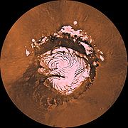
Mars has two permanent polar ice caps, the northern one located at Planum Boreum
Planum Boreum
Planum Boreum is the northern polar plain on Mars. It extends northward from roughly 80°N and is centered at . Surrounding the high polar plain is a flat and featureless lowland plain called Vastitas Borealis which extends for approximately 1500 kilometres southwards, dominating the northern...
and the southern one at Planum Australe
Planum Australe
Planum Australe is the southern polar plain on Mars. It extends southward of roughly 75°S and is centered at . The geology of this region was to be explored by the failed NASA mission Mars Polar Lander, which lost contact on entry into the Martian atmosphere.-Ice cap:Planum Australe is partially...
.
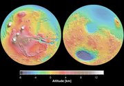
The difference between Mars' highest and lowest points is nearly 31 km (from the top of Olympus Mons at an altitude of 26 km to the bottom of the Hellas impact basin at an altitude of 4 km below the datum). In comparison, the difference between Earth's highest and lowest points (Mount Everest
Mount Everest
Mount Everest is the world's highest mountain, with a peak at above sea level. It is located in the Mahalangur section of the Himalayas. The international boundary runs across the precise summit point...
and the Mariana Trench
Mariana Trench
The Mariana Trench or Marianas Trench is the deepest part of the world's oceans. It is located in the western Pacific Ocean, to the east of the Mariana Islands. The trench is about long but has a mean width of only...
) is only 19.7 km. Combined with the planets' different radii, this means Mars is nearly three times "rougher" than Earth.
The International Astronomical Union
International Astronomical Union
The International Astronomical Union IAU is a collection of professional astronomers, at the Ph.D. level and beyond, active in professional research and education in astronomy...
's Working Group for Planetary System Nomenclature is responsible for naming Martian surface features.
Zero elevation
Since Mars has no oceans and hence no 'sea level', it is convenient to define an arbitrary zero-elevation level or "datum" for mapping the surface. The datum for Mars is defined in terms of the height at which the air has a particular pressure at about the freezing point of water: a pressure of 610.5 Pa (6.105 mbar), approximately 0.6% of Earth's, at a temperature of 273.16 K. This pressure and temperature correspond to the triple pointTriple point
In thermodynamics, the triple point of a substance is the temperature and pressure at which the three phases of that substance coexist in thermodynamic equilibrium...
of water. Conditions on Mars are so different from those on Earth that Martian altitude readings should not be directly compared to Earthly ones for purposes of finding life, potential colony sites, etc..
Zero meridian
Mars' equator is defined by its rotation, but the location of its Prime MeridianPrime Meridian
The Prime Meridian is the meridian at which the longitude is defined to be 0°.The Prime Meridian and its opposite the 180th meridian , which the International Date Line generally follows, form a great circle that divides the Earth into the Eastern and Western Hemispheres.An international...
was specified, as was Earth's, by choice of an arbitrary point which was accepted by later observers. The German astronomers Wilhelm Beer and Johann Heinrich Mädler selected a small circular feature as a reference point when they produced the first systematic chart of Mars features in 1830-32. In 1877, their choice was adopted as the prime meridian by the Italian astronomer Giovanni Schiaparelli
Giovanni Schiaparelli
Giovanni Virginio Schiaparelli was an Italian astronomer and science historian. He studied at the University of Turin and Berlin Observatory. In 1859-1860 he worked in Pulkovo Observatory and then worked for over forty years at Brera Observatory...
when he began work on his notable maps of Mars. After the spacecraft Mariner 9
Mariner 9
Mariner 9 was a NASA space orbiter that helped in the exploration of Mars and was part of the Mariner program. Mariner 9 was launched toward Mars on May 30, 1971 from Cape Canaveral Air Force Station and reached the planet on November 13 of the same year, becoming the first spacecraft to orbit...
provided extensive imagery of Mars in 1972, a small crater (later called Airy-0
Airy-0
Airy-0 is a crater on Mars whose location defines the position of the prime meridian of that planet. It is about across and lies within the larger crater Airy in the region Sinus Meridiani....
), located in the Sinus Meridiani
Sinus Meridiani
Sinus Meridiani is a feature name for an albedo feature on Mars stretching east-west just south of that planet's equator. It was named by the French astronomer Camille Flammarion in the late 1870s.-Observational History:...
('Middle Bay' or 'Meridian Bay') along the line of Beer and Mädler, was chosen by Merton Davies
Merton Davies
Merton E. Davies graduated from Stanford University in 1937 and worked for the Douglas Aircraft corporation in the 1940s. He became a pioneer of spy satellite technology as a member of RAND Corporation after it split off from Douglas in 1948...
of the RAND Corporation
RAND
RAND Corporation is a nonprofit global policy think tank first formed to offer research and analysis to the United States armed forces by Douglas Aircraft Company. It is currently financed by the U.S. government and private endowment, corporations including the healthcare industry, universities...
to provide a more precise definition of 0.0° longitude when he established a planetographic control point network.
Martian dichotomy
Observers of Martian topography will notice a dichotomy between the northern and southern hemispheres. The northern hemisphere is flat with few impact craters caused by asteroids. Most of the northern hemisphere is below the determined ‘zero elevation’ level. In contrast, the southern hemisphere is mountains and highlands, well above zero-elevation. The two hemispheres differ in elevation by 1 to 3 km. The border separating the two areas is very interesting to geologists. One distinctive feature is the Fretted terrainFretted terrain
Fretted terrain is a type of surface feature common to certain areas of Mars and discovered in Mariner 9 images. It lies between two different types of terrain...
. It contains mesas, knobs, and flat-floored valleys having walls about a mile high. Around many of the mesas and knobs are lobate debris apron
Lobate Debris Apron
Lobate debris aprons are geological features on Mars, first seen by the Viking Orbiters, consisting of piles of rock debris below cliffs. These features have a convex topography and a gentle slope from cliffs or escarpments, which suggest flow away from the steep source cliff...
s that have been shown to be rock covered glaciers. These glaciers may be used by future colonists as a source of water. Other interesting features are the large river valleys that cut through the dichotomy.
The northern lowlands comprise about one-third of the surface of Mars and are relatively flat, with occasional impact craters. The other two-thirds of the Martian surface are the highlands of the southern hemisphere. The difference in elevation between the hemispheres is dramatic. Because of the density of impact craters, scientists believe the southern hemisphere to be far older than the northern plains. The heavily cratered southern highlands date back to the period of heavy bombardment.
Multiple hypotheses have been proposed to explain the differences. The three most commonly accepted are: creation by a single mega-impact, creation by multiple impacts, or creation by endogenic processes such as mantle convection. Both impact-related hypotheses involve processes that could have occurred before the end of the primordial bombardment, implying that the crustal dichotomy has its origins early in the history of Mars.
Originally proposed in the early 1980s, the Giant Impact Theory was met with skepticism due to the impact area's non-radial (elliptical) shape, where a circular pattern would be stronger support for impact by larger object(s). But a 2008 study provided additional research that supports the single giant impact theory. Using geologic data, researchers found support for the single impact of a large object hitting Mars at approximately a 45-degree angle. Additional evidence analyzing Martian rock chemistry for post-impact upwelling of mantle material would further support the giant impact theory.
Early nomenclature
Although better remembered for mapping the MoonMoon
The Moon is Earth's only known natural satellite,There are a number of near-Earth asteroids including 3753 Cruithne that are co-orbital with Earth: their orbits bring them close to Earth for periods of time but then alter in the long term . These are quasi-satellites and not true moons. For more...
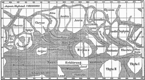
starting in 1830, Johann Heinrich Mädler and Wilhelm Beer were the first "areographers". They started off by establishing once and for all that most of the surface features were permanent, and pinned down Mars' rotation period. In 1840, Mädler combined ten years of observations and drew the first map of Mars ever made. Rather than giving names to the various markings they mapped, Beer and Mädler simply designated them with letters; Meridian Bay (Sinus Meridiani) was thus feature "a".
Over the next twenty years or so, as instruments improved and the number of observers also increased, various Martian features acquired a hodge-podge of names. To give a couple of examples, Solis Lacus
Solis Lacus
Solis Lacus is a dark feature on Mars. It was once called "Oculus" and is still commonly called "The Eye of Mars" because with the surrounding light area called Thaumasia it resembles the pupil of one. Solis Lacus is known for the variability of its appearance, changing its size and shape when...
was known as the "Oculus" (the Eye), and Syrtis Major was usually known as the "Hourglass Sea" or the "Scorpion". In 1858, it was also dubbed the "Atlantic Canale" by the Jesuit astronomer Angelo Secchi
Angelo Secchi
-External links:...
. Secchi commented that it "seems to play the role of the Atlantic which, on Earth, separates the Old Continent from the New" —this was the first time the fateful canale, which in Italian can mean either "channel" or "canal", had been applied to Mars.
In 1867, Richard Anthony Proctor
Richard Anthony Proctor
Richard Anthony Proctor was an English astronomer.He is best remembered for having produced one of the earliest maps of Mars in 1867 from 27 drawings by the English observer William Rutter Dawes....
drew up a map of Mars based, somewhat crudely, on the Rev. William Rutter Dawes
William Rutter Dawes
William Rutter Dawes was an English astronomer.Dawes was born in West Sussex, the son of William Dawes, also an astronomer, who travelled to the colony of New South Wales on the First Fleet in 1788....
' earlier drawings of 1865, then the best ones available. Proctor explained his system of nomenclature by saying, "I have applied to the different features the names of those observers who have studied the physical peculiarities presented by Mars." Here are some of his names, paired with those later used by Schiaparelli
Giovanni Schiaparelli
Giovanni Virginio Schiaparelli was an Italian astronomer and science historian. He studied at the University of Turin and Berlin Observatory. In 1859-1860 he worked in Pulkovo Observatory and then worked for over forty years at Brera Observatory...
in his Martian map created between 1877 and 1886. Schiaparelli's names were generally adopted and are the names actually used today:
- Kaiser Sea = Syrtis Major
- Lockyer Land = Hellas PlanitiaHellas PlanitiaHellas Planitia, also known as the Hellas Impact Basin, is a huge, roughly circular impact basin located in the southern hemisphere of the planet Mars. It is the second or third largest impact crater and the largest visible impact crater known in the Solar System...
- Main Sea = Lacus Moeris
- Herschel II Strait = Sinus Sabaeus
- Dawes Continent = Aeria and Arabia
- De La Rue Ocean = Mare ErythraeumMare ErythraeumMare Erythraeum is a very large dark dusky region of Mars that can be viewed by even a small telescope. The name comes from the Latin for the Erythraean Sea, because it was originally thought to be a large sea of liquid water. It was included in Percival Lowell's 1895 map of Mars.-External links:*...
- Lockyer Sea = Solis LacusSolis LacusSolis Lacus is a dark feature on Mars. It was once called "Oculus" and is still commonly called "The Eye of Mars" because with the surrounding light area called Thaumasia it resembles the pupil of one. Solis Lacus is known for the variability of its appearance, changing its size and shape when...
- Dawes Sea = Tithonius Lacus
- Madler Continent = Chryse PlanitiaChryse PlanitiaChryse Planitia is a smooth circular plain in the northern equatorial region of Mars close to the Tharsis region to the west, centered at . Chryse Planitia lies partially in the Lunae Palus quadrangle and partially in the Oxia Palus quadrangle...
, OphirOphir (disambiguation)Ophir is a region mentioned in the Bible that was famous for its wealth. It may also refer to:-People:Ophir is used as a first and last name among people of Jewish heritage, and others...
, TharsisTharsisThe Tharsis region on Mars is a vast volcanic plateau centered near the equator in Mars’ western hemisphere. The region is home to the largest volcanoes in the Solar System, including the three enormous shield volcanoes Arsia Mons, Pavonis Mons, and Ascraeus Mons, which are collectively known as... - Maraldi Sea = Maria Sirenum and Cimmerium
- Secchi Continent = Memnonia
- Hooke Sea = Mare Tyrrhenum
- Cassini Land = AusoniaAusonia-Places:Argentina* Ausonia, Argentina, a community in General San Martín Department, CórdobaItaly* Ausonia, Lazio, a comune in the Province of Frosinone-Ships:* German aircraft carrier I , a German aircraft carrier...
- Herschel I Continent = Zephyria, AeolisAeolisAeolis or Aeolia was an area that comprised the west and northwestern region of Asia Minor, mostly along the coast, and also several offshore islands , where the Aeolian Greek city-states were located...
, Aethiopis - Hind Land = LibyaLibya MontesThe Libya Montes are a ring of mountains on Mars up-lifted by the giant impact that created the Isidis basin to the north. During 1999, this region became one of the top two that were being considered for the now-canceled Mars Surveyor 2001 Lander. The Isidis basin is very, very ancient...
Proctor's nomenclature has often been criticized, mainly because so many of his names honored English astronomers, but also because he used many names more than once. In particular, Dawes
William Rutter Dawes
William Rutter Dawes was an English astronomer.Dawes was born in West Sussex, the son of William Dawes, also an astronomer, who travelled to the colony of New South Wales on the First Fleet in 1788....
appeared no fewer than six times (Dawes Ocean, Dawes Continent, Dawes Sea, Dawes Strait, Dawes Isle, and Dawes Forked Bay). Even so, Proctor's names are not without charm, and for all their shortcomings they were a foundation on which later astronomers would improve.
Modern nomenclature
Today, names of Martian features derive from a number of sources. Large albedoAlbedo
Albedo , or reflection coefficient, is the diffuse reflectivity or reflecting power of a surface. It is defined as the ratio of reflected radiation from the surface to incident radiation upon it...
features retain many of the older names, but are often updated to reflect new knowledge of the nature of the features. For example 'Nix Olympica' (the snows of Olympus) has become Olympus Mons
Olympus Mons
Olympus Mons is a large volcanic mountain on the planet Mars. At a height of almost , it is one of the tallest mountains in the Solar System, three times as tall as Mount Everest and more than twice the height of Mauna Kea the tallest mountain on Earth. Olympus Mons is the youngest of the large...
(Mount Olympus).
Large Martian craters are named after important scientists and science fiction writers; smaller ones are named after towns and villages on Earth.
Various landforms studied by the Mars Exploration Rover
Mars Exploration Rover
NASA's Mars Exploration Rover Mission is an ongoing robotic space mission involving two rovers, Spirit and Opportunity, exploring the planet Mars...
s are given temporary names or nicknames to identify them during exploration and investigation. However, it is hoped that the International Astronomical Union
International Astronomical Union
The International Astronomical Union IAU is a collection of professional astronomers, at the Ph.D. level and beyond, active in professional research and education in astronomy...
will make permanent the names of certain major features, such as the Columbia Hills, which were named after the seven astronauts who died in the Space Shuttle Columbia disaster
Space Shuttle Columbia disaster
The Space Shuttle Columbia disaster occurred on February 1, 2003, when shortly before it was scheduled to conclude its 28th mission, STS-107, the Space Shuttle Columbia disintegrated over Texas and Louisiana during re-entry into the Earth's atmosphere, resulting in the death of all seven crew members...
.
See also
- Geology of MarsGeology of MarsThe geology of Mars is the scientific study of the surface, crust, and interior of the planet Mars. It emphasizes the composition, structure, history, and physical processes that shape the planet. It is fully analogous to the field of terrestrial geology. In planetary science, the term geology is...
- Martian dichotomyMartian dichotomyThe most conspicuous feature of Martian surface geology is a sharp contrast, known as the Martian dichotomy, between the rugged southern highlands and the relatively smooth northern basins. The two hemispheres differ in elevation by 1 to 3 km...
- List of quadrangles on Mars
- :Category:Surface features of Mars - Category of various surface features on Mars
Further reading
- Sheehan, William, "The Planet Mars: A History of Observation and Discovery" (Full text online) The University of Arizona Press, Tucson. 1996.
External links
- Google Mars - Google MapsGoogle MapsGoogle Maps is a web mapping service application and technology provided by Google, free , that powers many map-based services, including the Google Maps website, Google Ride Finder, Google Transit, and maps embedded on third-party websites via the Google Maps API...
for Mars, with various surface features and interesting places pointed out - Mars Maps - Maps of Mars
- MEC-1 Prototype
- Historical Globes of the Red Planet