
Planum Boreum
Encyclopedia
Planum Boreum is the northern polar plain on Mars
. It extends northward from roughly 80°N and is centered at 88.0°N 15.0°W. Surrounding the high polar plain is a flat and featureless lowland plain called Vastitas Borealis
which extends for approximately 1500 kilometres southwards, dominating the northern hemisphere. In 1999, the Hubble Space Telescope
captured a cyclonic storm in the region. The diameter of the storm was approximately 1750 km and featured an eye 320 kilometres in diameter.
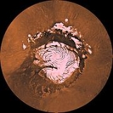
 Planum Boreum is home to a permanent ice cap
consisting mainly of water
and carbon dioxide
ice. It has a volume of 1.2 million cubic kilometres and covers an area equivalent to about 1.5 times the size of Texas
. It has a radius of 600 km. The maximum depth of the cap is 3 km. The spiral patterns in the ice cap are dune-like features analogous to megadunes in Antarctica. Katabatic wind
s driven by the Coriolis effect
entrain and redeposit surface ice to make the pattern.
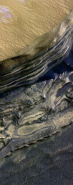
The surface composition of the northern ice cap in middle spring (after a winter's accumulation of seasonal dry ice) has been studied from orbit. The outer edges of the ice cap are contaminated with dust (0.15% by weight) and are mostly water ice. As one moves toward the pole, the surface water ice content decreases and is replaced by dry ice. The purity of the ice also increases. At the pole, the surface seasonal ice consists of essentially pure dry ice with little dust content and 30 parts per million of water ice.
The Phoenix
lander, launched in 2007, arrived at Mars in May 2008 and successfully landed in the Vastitas Borealis region of the planet on May 25, 2008. The polar cap of Mars has been proposed as a landing site for a human Mars expedition by Landis
and by Cockell.
. It is up to 100 km wide and features scarps up to 2 km high. By comparison, the Grand Canyon
is approximately 1.6 km deep in some places and 446 km long but only up to 24 km wide. Chasma Boreale cuts through polar deposits and ice, such as those present at Greenland
.
Planum Boreum interfaces with Vastitas Borealis west of Chasma Boreale at an irregular scarp named Rupes Tenuis. This scarp reaches heights of up to 1 km. At other places, the interface is a collection of mesas and troughs.
Planum Boreum is surrounded by large fields of sand dunes spanning from 75°N to 85°N. These dune fields are named Olympia Undae
, Abalos Undae and Hyperboreae Undae. Olympia Undae, by far the largest, covers from 100°E to 240°E. Abalos Undae covers from 261°E to 280°E and Hyperboreale Undae spans from 311°E to 341°E. See also List of extraterrestrial dune fields.
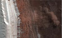 A February 2008 HiRISE observation captured four avalanche
s in progress off a 700 meter cliff. The cloud of fine material is 180 meters across and extends 190 meters from the base of the cliff. The reddish layers are known to be rock rich in water ice while the white layers are seasonal carbon dioxide frost. The landslide is thought to have originated from the uppermost red layer. Follow-up observations are planned to characterize the nature of the landslide debris.
Mars
Mars is the fourth planet from the Sun in the Solar System. The planet is named after the Roman god of war, Mars. It is often described as the "Red Planet", as the iron oxide prevalent on its surface gives it a reddish appearance...
. It extends northward from roughly 80°N and is centered at 88.0°N 15.0°W. Surrounding the high polar plain is a flat and featureless lowland plain called Vastitas Borealis
Vastitas Borealis
Vastitas Borealis is the largest lowland region of Mars. It is in the northerly latitudes of the planet and encircles the northern polar region. Vastitas Borealis is often simply referred to as the Northern plains or Northern lowlands of Mars. The plains lie 4–5 km below the mean radius of...
which extends for approximately 1500 kilometres southwards, dominating the northern hemisphere. In 1999, the Hubble Space Telescope
Hubble Space Telescope
The Hubble Space Telescope is a space telescope that was carried into orbit by a Space Shuttle in 1990 and remains in operation. A 2.4 meter aperture telescope in low Earth orbit, Hubble's four main instruments observe in the near ultraviolet, visible, and near infrared...
captured a cyclonic storm in the region. The diameter of the storm was approximately 1750 km and featured an eye 320 kilometres in diameter.
Ice cap
Polar ice cap
A polar ice cap is a high latitude region of a planet or natural satellite that is covered in ice. There are no requirements with respect to size or composition for a body of ice to be termed a polar ice cap, nor any geological requirement for it to be over land; only that it must be a body of...
consisting mainly of water
Water
Water is a chemical substance with the chemical formula H2O. A water molecule contains one oxygen and two hydrogen atoms connected by covalent bonds. Water is a liquid at ambient conditions, but it often co-exists on Earth with its solid state, ice, and gaseous state . Water also exists in a...
and carbon dioxide
Carbon dioxide
Carbon dioxide is a naturally occurring chemical compound composed of two oxygen atoms covalently bonded to a single carbon atom...
ice. It has a volume of 1.2 million cubic kilometres and covers an area equivalent to about 1.5 times the size of Texas
Texas
Texas is the second largest U.S. state by both area and population, and the largest state by area in the contiguous United States.The name, based on the Caddo word "Tejas" meaning "friends" or "allies", was applied by the Spanish to the Caddo themselves and to the region of their settlement in...
. It has a radius of 600 km. The maximum depth of the cap is 3 km. The spiral patterns in the ice cap are dune-like features analogous to megadunes in Antarctica. Katabatic wind
Katabatic wind
A katabatic wind, from the Greek word katabatikos meaning "going downhill", is the technical name for a drainage wind, a wind that carries high density air from a higher elevation down a slope under the force of gravity. Such winds are sometimes also called fall winds...
s driven by the Coriolis effect
Coriolis effect
In physics, the Coriolis effect is a deflection of moving objects when they are viewed in a rotating reference frame. In a reference frame with clockwise rotation, the deflection is to the left of the motion of the object; in one with counter-clockwise rotation, the deflection is to the right...
entrain and redeposit surface ice to make the pattern.
The surface composition of the northern ice cap in middle spring (after a winter's accumulation of seasonal dry ice) has been studied from orbit. The outer edges of the ice cap are contaminated with dust (0.15% by weight) and are mostly water ice. As one moves toward the pole, the surface water ice content decreases and is replaced by dry ice. The purity of the ice also increases. At the pole, the surface seasonal ice consists of essentially pure dry ice with little dust content and 30 parts per million of water ice.
The Phoenix
Phoenix (spacecraft)
Phoenix was a robotic spacecraft on a space exploration mission on Mars under the Mars Scout Program. The Phoenix lander descended on Mars on May 25, 2008...
lander, launched in 2007, arrived at Mars in May 2008 and successfully landed in the Vastitas Borealis region of the planet on May 25, 2008. The polar cap of Mars has been proposed as a landing site for a human Mars expedition by Landis
Geoffrey A. Landis
Geoffrey A. Landis is an American scientist, working for the National Aeronautics and Space Administration on planetary exploration, interstellar propulsion, solar power and photovoltaics...
and by Cockell.
Features
The main feature of the Planum Boreum is a large fissure or canyon in the polar ice cap called Chasma BorealeChasma Boreale
Chasma Boreale is a large canyon in the Mare Boreum quadrangle of Mars at 83° north latitude and 47.1° west longitude. It is about long and was named after a classical albedo feature name. The canyon shows layered features that result from seasonal melting and deposition of ice, together with...
. It is up to 100 km wide and features scarps up to 2 km high. By comparison, the Grand Canyon
Grand Canyon
The Grand Canyon is a steep-sided canyon carved by the Colorado River in the United States in the state of Arizona. It is largely contained within the Grand Canyon National Park, the 15th national park in the United States...
is approximately 1.6 km deep in some places and 446 km long but only up to 24 km wide. Chasma Boreale cuts through polar deposits and ice, such as those present at Greenland
Greenland
Greenland is an autonomous country within the Kingdom of Denmark, located between the Arctic and Atlantic Oceans, east of the Canadian Arctic Archipelago. Though physiographically a part of the continent of North America, Greenland has been politically and culturally associated with Europe for...
.
Planum Boreum interfaces with Vastitas Borealis west of Chasma Boreale at an irregular scarp named Rupes Tenuis. This scarp reaches heights of up to 1 km. At other places, the interface is a collection of mesas and troughs.
Planum Boreum is surrounded by large fields of sand dunes spanning from 75°N to 85°N. These dune fields are named Olympia Undae
Olympia Undae
Olympia Undae is a vast dune field in the north polar region of the planet Mars. It consists of a broad “sand sea” or erg that partly rings the north polar plateau from about 120° to 240°E longitude and 78° to 83°N latitude. Stretching about across and covering an area of 470,000 km2,...
, Abalos Undae and Hyperboreae Undae. Olympia Undae, by far the largest, covers from 100°E to 240°E. Abalos Undae covers from 261°E to 280°E and Hyperboreale Undae spans from 311°E to 341°E. See also List of extraterrestrial dune fields.
Avalanches
Avalanche
An avalanche is a sudden rapid flow of snow down a slope, occurring when either natural triggers or human activity causes a critical escalating transition from the slow equilibrium evolution of the snow pack. Typically occurring in mountainous terrain, an avalanche can mix air and water with the...
s in progress off a 700 meter cliff. The cloud of fine material is 180 meters across and extends 190 meters from the base of the cliff. The reddish layers are known to be rock rich in water ice while the white layers are seasonal carbon dioxide frost. The landslide is thought to have originated from the uppermost red layer. Follow-up observations are planned to characterize the nature of the landslide debris.
External links
- Fly over the Chasma Boreale at Martian north pole - courtesy of Mars ExpressMars ExpressMars Express is a space exploration mission being conducted by the European Space Agency . The Mars Express mission is exploring the planet Mars, and is the first planetary mission attempted by the agency. "Express" originally referred to the speed and efficiency with which the spacecraft was...
- Geologic Map of the Northern Plains of Mars
- HiRISE image of Martian landslides
- HiRISE image of permanent ice mound separated from cap
- Various HiRISEHiRISEHigh Resolution Imaging Science Experiment is a camera on board the Mars Reconnaissance Orbiter. The 65 kg , $40 million instrument was built under the direction of the University of Arizona's Lunar and Planetary Laboratory by Ball Aerospace & Technologies Corp....
images of the north polar ice cap: http://hiroc.lpl.arizona.edu/images/PSP/PSP_001412_2650/ http://hiroc.lpl.arizona.edu/images/PSP/PSP_001334_2645/color.html http://hiroc.lpl.arizona.edu/images/PSP/PSP_001513_2650/ http://hiroc.lpl.arizona.edu/images/PSP/PSP_001406_2680/