
Mars Global Surveyor
Encyclopedia
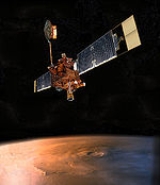
The Mars Global Surveyor (MGS) was a US spacecraft
developed by NASA
's Jet Propulsion Laboratory
and launched November 1996. It began the United States's return to Mars
after a 10-year absence. It completed its primary mission in January 2001 and was in its third extended mission phase when, on 2 November 2006, the spacecraft failed to respond to messages and commands. A faint signal was detected three days later which indicated that the craft had gone into safe mode
. All attempts to recontact the Mars Global Surveyor and resolve the problem failed. In January 2007 NASA officially ended the mission.
Astronautics plant in Denver
, is a rectangular-shaped box with wing-like projections (solar panels
) extending from opposite sides. When fully loaded with propellant at the time of launch, the spacecraft weighed 1060 kg (2,337 lb). Most of Surveyor' s mass lies in the box-shaped module occupying the center portion of the spacecraft. This center module is made of two smaller rectangular modules stacked on top of each other, one of which is called the equipment module and holds the spacecraft's electronics, science instruments
, and the 1750A mission computer. The other module, called the propulsion
module, houses Surveyors rocket
engines and propellant
tanks.
s fly onboard Mars Global Surveyor:
The Mars Orbiter Camera
(MOC) science investigation used 3 instruments: a narrow angle camera that took (black-and-white) high resolution images (usually 1.5 to 12 m per pixel) and red and blue wide angle pictures for context (240 m per pixel) and daily global imaging (7.5 km per pixel). MOC returned more than 240,000 images spanning portions of 4.8 Martian years, from September 1997 and November 2006. A high resolution image from MOC is either 1.5 or 3.1 km wide. So any image from this camera is at most 3.1 km wide. Often, a picture will be smaller than this because it has been cut to just show a certain feature. These high resolution images may be 3 to 10 km long. When a high resolution image is taken, a context image is taken as well. The context image shows the image footprint of the high resolution picture. Context images are typically 115.2 km square with 240 m/pixel resolution.
The Mars Relay antenna supported the Mars Exploration Rovers for data relay in conjunction with Mars Orbiter Camera's 12 MB memory buffer. In total, more than 7.6 terabit
s of data were transferred this way.
Air Station in Florida on 7 November 1996 aboard a Delta II
rocket. The spacecraft traveled nearly 750 million kilometers (466 million miles) over the course of a 300-day cruise to reach Mars on 11 September 1997.
Upon reaching Mars, Surveyor fired its main rocket engine for the 22-minute Mars orbit insertion
(MOI) burn. This maneuver slowed the spacecraft and allowed the planet's gravity to capture it into orbit
. Initially, Surveyor entered a highly elliptical orbit that took 45 hours to complete. The orbit had a periapsis of 262 km (163 mi) above the northern hemisphere, and an apoapsis of 54026 km (33,570 mi) above the southern hemisphere.
technique over a period of four months to lower the high point of its orbit from 54000 km (33,554 mi) to altitudes near 450 km (280 mi).
On 11 October, the flight team performed a maneuver to raise the periapsis out of the atmosphere. This suspension of aerobraking was performed because air pressure from the atmosphere caused one of Surveyors two solar panel
s to bend backward by a slight amount. The panel in question was slightly damaged shortly after launch in November 1996. Aerobraking was resumed on 7 November after flight team members concluded that aerobraking was safe, provided that it occurs at a more gentle pace than proposed by the original mission plan.
 Under the new mission plan, aerobraking occurred with the low point of the orbit at an average altitude of 120 km (75 mi), as opposed to the original altitude of 110 km (68 mi). This slightly higher altitude resulted in a decrease of 66 percent in terms of air resistance pressure experienced by the spacecraft. During these six months, aerobraking reduced the orbit period to between 12 and 6 hours.
From May to November 1998, aerobraking was temporarily suspended to allow the orbit to drift into the proper position with respect to the Sun
. Without this hiatus, 'Surveyor' would complete aerobraking with its orbit in the wrong solar orientation. In order to maximize the efficiency of the mission, these six months were devoted to collecting as much science data as possible. Data was collected between two to four times per day, at the low point of each orbit.
Finally, from November 1998 to March 1999, aerobraking continued and shrank the high point of the orbit down to 450 km (280 mi). At this altitude, Surveyor circled Mars once every two hours. Aerobraking was scheduled to terminate at the same time the orbit drifted into its proper position with respect to the Sun. In the desired orientation for mapping operations, the spacecraft always crossed the day-side equator
at 14:00 (local Mars time) moving from south to north. This geometry was selected to enhance the total quality of the science return.
and 88 orbits, the spacecraft would approximately retrace its previous path, with an offset of 59 km to the east. This ensured eventual full coverage of the entire surface.
In its extended mission, MGS did much more than study the planet directly beneath it. It commonly performed rolls and pitches to acquire images off its nadir
track. The roll maneuvers, called ROTOs (Roll Only Targeting Opportunities), rolled the spacecraft left or right from its ground track to shoot images as much as 30° from nadir. It was possible for a pitch maneuver to be added to compensate for the relative motion between the spacecraft and the planet. This was called a CPROTO (Compensation Pitch Roll Targeting Opportunity), and allowed for some very high resolution imaging by the onboard MOC (Mars Orbiting Camera).
In addition to this, MGS could shoot pictures of other orbiting bodies, such as other spacecraft and the moons of Mars. In 1998 it imaged what was later called the Phobos monolith
, found in MOC Image 55103.
Results from the Mars Global Surveyor primary mission (1996–2001) were published in the Journal of Geophysical Research by M. Malin and K. Edgett. Some of these discoveries are:
relaying data back to Earth from the MER
surface landers. Portions of MGS had been scheduled to remain active until at least September 2008 to support MER.
On November 20, 2006, the Mars Reconnaissance Orbiter
spacecraft attempted to image Mars Global Surveyor to verify the orientation of the spacecraft. The effort was unsuccessful.
On November 21 and 22, 2006, Mars Global Surveyor failed to relay communications to the Opportunity rover on the surface of Mars. In response to this complication, Mars Exploration Program manager Fuk Li stated, "Realistically, we have run through the most likely possibilities for re-establishing communication, and we are facing the likelihood that the amazing flow of scientific observations from Mars Global Surveyor is over."
On April 13, 2007, NASA announced the loss of the spacecraft was caused by a flaw in a parameter update to the spacecraft's system software. The spacecraft was designed to hold two identical copies of the system software for redundancy and error checking. Subsequent updating to the software encountered human error when two independent operators updated separate copies with differing parameters followed by a corrective update that unknowingly included a memory fault which resulted in the loss of the spacecraft.
Originally, the spacecraft was intended to observe Mars for 1 Martian year (approximately 2 Earth years). However, based on the vast amount of valuable science data returned, NASA
had previously extended the mission three times.
of the orbital plane of a test particle moving around a central, rotating mass such as a planet. The interpretation of the out-of-plane Root-Mean-Square (RMS) time series of MGS in terms of such a relativistic feature of motion by L. Iorio was criticized by K. Krogh; however, L. Iorio supported his thesis with new arguments.
 On 6 December 2006 NASA released photos of two craters called Terra Sirenum
and Centauri Montes
which appear to show the presence of water on Mars at some point between 1999 and 2001. The pictures were produced by the Mars Global Surveyor and are quite possibly the spacecraft's final contribution to our knowledge of Mars and the question of whether life or water exists on the planet.
Hundreds of gullies were discovered that were formed from liquid water, possible in recent times. These gullies occur on steep slopes and mostly in certain bands of latitude.
A few channels on Mars displayed inner channels that suggest sustained fluid flows. The most well-known is the one in Nanedi Valles
. Another was found in Nirgal Vallis
.
The Mars Global Surveyor (MGS) was a US spacecraft
developed by NASA
's Jet Propulsion Laboratory
and launched November 1996. It began the United States's return to Mars
after a 10-year absence. It completed its primary mission in January 2001 and was in its third extended mission phase when, on 2 November 2006, the spacecraft failed to respond to messages and commands. A faint signal was detected three days later which indicated that the craft had gone into safe mode
. All attempts to recontact the Mars Global Surveyor and resolve the problem failed. In January 2007 NASA officially ended the mission.
Astronautics plant in Denver
, is a rectangular-shaped box with wing-like projections (solar panels
) extending from opposite sides. When fully loaded with propellant at the time of launch, the spacecraft weighed 1060 kg (2,337 lb). Most of Surveyor' s mass lies in the box-shaped module occupying the center portion of the spacecraft. This center module is made of two smaller rectangular modules stacked on top of each other, one of which is called the equipment module and holds the spacecraft's electronics, science instruments
, and the 1750A mission computer. The other module, called the propulsion
module, houses Surveyors rocket
engines and propellant
tanks.
s fly onboard Mars Global Surveyor:
The Mars Orbiter Camera
(MOC) science investigation used 3 instruments: a narrow angle camera that took (black-and-white) high resolution images (usually 1.5 to 12 m per pixel) and red and blue wide angle pictures for context (240 m per pixel) and daily global imaging (7.5 km per pixel). MOC returned more than 240,000 images spanning portions of 4.8 Martian years, from September 1997 and November 2006. A high resolution image from MOC is either 1.5 or 3.1 km wide. So any image from this camera is at most 3.1 km wide. Often, a picture will be smaller than this because it has been cut to just show a certain feature. These high resolution images may be 3 to 10 km long. When a high resolution image is taken, a context image is taken as well. The context image shows the image footprint of the high resolution picture. Context images are typically 115.2 km square with 240 m/pixel resolution.
The Mars Relay antenna supported the Mars Exploration Rovers for data relay in conjunction with Mars Orbiter Camera's 12 MB memory buffer. In total, more than 7.6 terabit
s of data were transferred this way.
Air Station in Florida on 7 November 1996 aboard a Delta II
rocket. The spacecraft traveled nearly 750 million kilometers (466 million miles) over the course of a 300-day cruise to reach Mars on 11 September 1997.
Upon reaching Mars, Surveyor fired its main rocket engine for the 22-minute Mars orbit insertion
(MOI) burn. This maneuver slowed the spacecraft and allowed the planet's gravity to capture it into orbit
. Initially, Surveyor entered a highly elliptical orbit that took 45 hours to complete. The orbit had a periapsis of 262 km (163 mi) above the northern hemisphere, and an apoapsis of 54026 km (33,570 mi) above the southern hemisphere.
technique over a period of four months to lower the high point of its orbit from 54000 km (33,554 mi) to altitudes near 450 km (280 mi).
On 11 October, the flight team performed a maneuver to raise the periapsis out of the atmosphere. This suspension of aerobraking was performed because air pressure from the atmosphere caused one of Surveyors two solar panel
s to bend backward by a slight amount. The panel in question was slightly damaged shortly after launch in November 1996. Aerobraking was resumed on 7 November after flight team members concluded that aerobraking was safe, provided that it occurs at a more gentle pace than proposed by the original mission plan.
Under the new mission plan, aerobraking occurred with the low point of the orbit at an average altitude of 120 km (75 mi), as opposed to the original altitude of 110 km (68 mi). This slightly higher altitude resulted in a decrease of 66 percent in terms of air resistance pressure experienced by the spacecraft. During these six months, aerobraking reduced the orbit period to between 12 and 6 hours.
From May to November 1998, aerobraking was temporarily suspended to allow the orbit to drift into the proper position with respect to the Sun
. Without this hiatus, 'Surveyor' would complete aerobraking with its orbit in the wrong solar orientation. In order to maximize the efficiency of the mission, these six months were devoted to collecting as much science data as possible. Data was collected between two to four times per day, at the low point of each orbit.
Finally, from November 1998 to March 1999, aerobraking continued and shrank the high point of the orbit down to 450 km (280 mi). At this altitude, Surveyor circled Mars once every two hours. Aerobraking was scheduled to terminate at the same time the orbit drifted into its proper position with respect to the Sun. In the desired orientation for mapping operations, the spacecraft always crossed the day-side equator
at 14:00 (local Mars time) moving from south to north. This geometry was selected to enhance the total quality of the science return.
and 88 orbits, the spacecraft would approximately retrace its previous path, with an offset of 59 km to the east. This ensured eventual full coverage of the entire surface.
In its extended mission, MGS did much more than study the planet directly beneath it. It commonly performed rolls and pitches to acquire images off its nadir
track. The roll maneuvers, called ROTOs (Roll Only Targeting Opportunities), rolled the spacecraft left or right from its ground track to shoot images as much as 30° from nadir. It was possible for a pitch maneuver to be added to compensate for the relative motion between the spacecraft and the planet. This was called a CPROTO (Compensation Pitch Roll Targeting Opportunity), and allowed for some very high resolution imaging by the onboard MOC (Mars Orbiting Camera).
In addition to this, MGS could shoot pictures of other orbiting bodies, such as other spacecraft and the moons of Mars. In 1998 it imaged what was later called the Phobos monolith
, found in MOC Image 55103.
Results from the Mars Global Surveyor primary mission (1996–2001) were published in the Journal of Geophysical Research by M. Malin and K. Edgett. Some of these discoveries are:
relaying data back to Earth from the MER
surface landers. Portions of MGS had been scheduled to remain active until at least September 2008 to support MER.
On November 20, 2006, the Mars Reconnaissance Orbiter
spacecraft attempted to image Mars Global Surveyor to verify the orientation of the spacecraft. The effort was unsuccessful.
On November 21 and 22, 2006, Mars Global Surveyor failed to relay communications to the Opportunity rover on the surface of Mars. In response to this complication, Mars Exploration Program manager Fuk Li stated, "Realistically, we have run through the most likely possibilities for re-establishing communication, and we are facing the likelihood that the amazing flow of scientific observations from Mars Global Surveyor is over."
On April 13, 2007, NASA announced the loss of the spacecraft was caused by a flaw in a parameter update to the spacecraft's system software. The spacecraft was designed to hold two identical copies of the system software for redundancy and error checking. Subsequent updating to the software encountered human error when two independent operators updated separate copies with differing parameters followed by a corrective update that unknowingly included a memory fault which resulted in the loss of the spacecraft.
Originally, the spacecraft was intended to observe Mars for 1 Martian year (approximately 2 Earth years). However, based on the vast amount of valuable science data returned, NASA
had previously extended the mission three times.
of the orbital plane of a test particle moving around a central, rotating mass such as a planet. The interpretation of the out-of-plane Root-Mean-Square (RMS) time series of MGS in terms of such a relativistic feature of motion by L. Iorio was criticized by K. Krogh; however, L. Iorio supported his thesis with new arguments.
On 6 December 2006 NASA released photos of two craters called Terra Sirenum
and Centauri Montes
which appear to show the presence of water on Mars at some point between 1999 and 2001. The pictures were produced by the Mars Global Surveyor and are quite possibly the spacecraft's final contribution to our knowledge of Mars and the question of whether life or water exists on the planet.
Hundreds of gullies were discovered that were formed from liquid water, possible in recent times. These gullies occur on steep slopes and mostly in certain bands of latitude.
A few channels on Mars displayed inner channels that suggest sustained fluid flows. The most well-known is the one in Nanedi Valles
. Another was found in Nirgal Vallis
.
The Mars Global Surveyor (MGS) was a US spacecraft
developed by NASA
's Jet Propulsion Laboratory
and launched November 1996. It began the United States's return to Mars
after a 10-year absence. It completed its primary mission in January 2001 and was in its third extended mission phase when, on 2 November 2006, the spacecraft failed to respond to messages and commands. A faint signal was detected three days later which indicated that the craft had gone into safe mode
. All attempts to recontact the Mars Global Surveyor and resolve the problem failed. In January 2007 NASA officially ended the mission.
Astronautics plant in Denver
, is a rectangular-shaped box with wing-like projections (solar panels
) extending from opposite sides. When fully loaded with propellant at the time of launch, the spacecraft weighed 1060 kg (2,337 lb). Most of Surveyor' s mass lies in the box-shaped module occupying the center portion of the spacecraft. This center module is made of two smaller rectangular modules stacked on top of each other, one of which is called the equipment module and holds the spacecraft's electronics, science instruments
, and the 1750A mission computer. The other module, called the propulsion
module, houses Surveyors rocket
engines and propellant
tanks.
s fly onboard Mars Global Surveyor:
The Mars Orbiter Camera
(MOC) science investigation used 3 instruments: a narrow angle camera that took (black-and-white) high resolution images (usually 1.5 to 12 m per pixel) and red and blue wide angle pictures for context (240 m per pixel) and daily global imaging (7.5 km per pixel). MOC returned more than 240,000 images spanning portions of 4.8 Martian years, from September 1997 and November 2006. A high resolution image from MOC is either 1.5 or 3.1 km wide. So any image from this camera is at most 3.1 km wide. Often, a picture will be smaller than this because it has been cut to just show a certain feature. These high resolution images may be 3 to 10 km long. When a high resolution image is taken, a context image is taken as well. The context image shows the image footprint of the high resolution picture. Context images are typically 115.2 km square with 240 m/pixel resolution.
The Mars Relay antenna supported the Mars Exploration Rovers for data relay in conjunction with Mars Orbiter Camera's 12 MB memory buffer. In total, more than 7.6 terabit
s of data were transferred this way.
Air Station in Florida on 7 November 1996 aboard a Delta II
rocket. The spacecraft traveled nearly 750 million kilometers (466 million miles) over the course of a 300-day cruise to reach Mars on 11 September 1997.
Upon reaching Mars, Surveyor fired its main rocket engine for the 22-minute Mars orbit insertion
(MOI) burn. This maneuver slowed the spacecraft and allowed the planet's gravity to capture it into orbit
. Initially, Surveyor entered a highly elliptical orbit that took 45 hours to complete. The orbit had a periapsis of 262 km (163 mi) above the northern hemisphere, and an apoapsis of 54026 km (33,570 mi) above the southern hemisphere.
technique over a period of four months to lower the high point of its orbit from 54000 km (33,554 mi) to altitudes near 450 km (280 mi).
On 11 October, the flight team performed a maneuver to raise the periapsis out of the atmosphere. This suspension of aerobraking was performed because air pressure from the atmosphere caused one of Surveyors two solar panel
s to bend backward by a slight amount. The panel in question was slightly damaged shortly after launch in November 1996. Aerobraking was resumed on 7 November after flight team members concluded that aerobraking was safe, provided that it occurs at a more gentle pace than proposed by the original mission plan.
Under the new mission plan, aerobraking occurred with the low point of the orbit at an average altitude of 120 km (75 mi), as opposed to the original altitude of 110 km (68 mi). This slightly higher altitude resulted in a decrease of 66 percent in terms of air resistance pressure experienced by the spacecraft. During these six months, aerobraking reduced the orbit period to between 12 and 6 hours.
From May to November 1998, aerobraking was temporarily suspended to allow the orbit to drift into the proper position with respect to the Sun
. Without this hiatus, 'Surveyor' would complete aerobraking with its orbit in the wrong solar orientation. In order to maximize the efficiency of the mission, these six months were devoted to collecting as much science data as possible. Data was collected between two to four times per day, at the low point of each orbit.
Finally, from November 1998 to March 1999, aerobraking continued and shrank the high point of the orbit down to 450 km (280 mi). At this altitude, Surveyor circled Mars once every two hours. Aerobraking was scheduled to terminate at the same time the orbit drifted into its proper position with respect to the Sun. In the desired orientation for mapping operations, the spacecraft always crossed the day-side equator
at 14:00 (local Mars time) moving from south to north. This geometry was selected to enhance the total quality of the science return.
and 88 orbits, the spacecraft would approximately retrace its previous path, with an offset of 59 km to the east. This ensured eventual full coverage of the entire surface.
In its extended mission, MGS did much more than study the planet directly beneath it. It commonly performed rolls and pitches to acquire images off its nadir
track. The roll maneuvers, called ROTOs (Roll Only Targeting Opportunities), rolled the spacecraft left or right from its ground track to shoot images as much as 30° from nadir. It was possible for a pitch maneuver to be added to compensate for the relative motion between the spacecraft and the planet. This was called a CPROTO (Compensation Pitch Roll Targeting Opportunity), and allowed for some very high resolution imaging by the onboard MOC (Mars Orbiting Camera).
In addition to this, MGS could shoot pictures of other orbiting bodies, such as other spacecraft and the moons of Mars. In 1998 it imaged what was later called the Phobos monolith
, found in MOC Image 55103.
Results from the Mars Global Surveyor primary mission (1996–2001) were published in the Journal of Geophysical Research by M. Malin and K. Edgett. Some of these discoveries are:
Image:Layers in a crater in Arabia.JPG|Layers in an old crater in Arabia, as seen by Mars Global Surveyor (MGS). Layers may form from volcanoes, the wind, or by deposition under water. The craters on the left are pedestal craters.
Image:Schiaparelli basin crater.jpg|Layers in crater found within the Schiaparelli crater basin as seen by Mars Global Surveyor. Image from the Sinus Sabaeus quadrangle
.
Image:Layers in Monument Valley.jpg|Layers in Monument Valley
. These are accepted as being formed, at least in part, by water deposition. Since Mars contains similar layers, water remains as a major cause of layering on Mars.
Image:Buttes and layers in Aeolis.jpg|Buttes and layers in Aeolis quadrangle
, as seen by Mars Global Surveyor.
Image:Exhumed crater in Noachis.JPG|Crater that was buried in another age and is now being exposed by erosion, as seen by the Mars Global Surveyor. Image is located in the Noachis quadrangle
.
Image:Exhumed Lava Flows.jpg|Lava flows were once covered over, now these platy flows are being exposed.
Image:Exhumed Crater.jpg|Crater was buried, now it is being exhumed by erosion. Image located in Ismenius Lacus quadrangle
.
Image:Exhumed Craters.jpg|The northern hemisphere appears smooth, but the craters are covered over. Here, a group of craters are patially exposed. Image located in Cebrenia quadrangle
.
Image:Gully in Phaethontis.jpg|Group of gullies on north wall of crater that lies west of the crater Newton (41.3047 degrees south latitude, 192.89 east longitide). Image taken with Mars Global Surveyor. Image is located in the Phaethontis quadrangle
.
Image:Gullies and tongue-shaped glacier.jpg|Gullies in a crater in Eridania quadrangle
, north of the large crater Kepler. Also, features that may be remains of old glaciers are present. One, to the right, has the shape of a tongue.
Image:Kaiser Gullies.JPG|Gullies on one wall of Kaiser Crater. Gullies usually are found in only one wall of a crater.
Image:Gullies in Gorgonum.jpg|Full color image of gullies on wall of Gorgonum Chaos
. Image is located in the Phaethontis quadrangle
.
Image:Phaethontis surface.JPG|Close up image of Phaethontis surface taken with Mars Global Surveyor. Pits are thought to be caused by buried ice turning into a gas.
Image:Mantle on Cliff.JPG|The mantle drapes most of the area. Note the absence of boulders on the cliff face. An area that shows the edges of the mantle is circled. Image located in Ismenius Lacus quadrangle
.
Image:Mantle material from MGS.jpg|Mantle material, as seen by MGS.
Image:Steep cliff in Ismenius Lacus taken with MGS.JPG|Steep Cliff in Ismenius Lacus quadrangle
with smooth mantle covering its face.
Image:Dust devil tracks in Eridania.JPG|Pattern of large and small tracks made by giant dust devils as seen by Mars Global Surveyor. Image is located in Eridania quadrangle
.
Image:Kepler Crater.JPG|Kepler (Martian crater)
showing dust devil tracks, as seen by Mars Global Surveyor. Kepler is a large crater in the Eridania quadrangle
.
Image:Dust Devil with Labels.JPG|Dust Devil, as seen by MGS.
Image:Dust Devil with Shadow.JPG|Dust Devil in action showing shadow to the right. Image located in Cebrenia quadrangle
.
Image:South pole changes in two year period.JPG|Changes in South Pole from 1999 to 2001, as seen by Mars Global Surveyor. Notice how swiss-cheese type holes have grown in the two years.
Image:Swiss Cheese in South.JPG|Swiss Cheese Terrain, as seen by MGS. Largest mesa in image is 4 meters high.
Image:Swiss Cheese Layers.JPG|Layers in Swiss Cheese Terrain. There is a bright upper layer and a darker lower layer.
Image:Swiss Cheese Terrain close-up.JPG|Close-up view of Swiss Cheese Terrain. Polygonal pattern was probably formed by shallow troughs.
Image:Cerauniustholus.jpg|Ceraunius Tholus, one of many volcanoes found on Mars.
Image:LavaFlows from MGS.JPG|Lava flows in the Tharsis quadrangle
.
Image:Young and Old Lava Flows.JPG|Image shows both young and old lava flows from the base of Olympus Mons
. The flat plain is the younger flow. The older flow has channels with levees along their edges. The presence of levees is quite common in many lava flows.
Image:Small Volcano mgs.jpg|Small Volcano in Phoenicis Lacus quadrangle
. Image is 1.9 miles (3.1 km) wide.
Image:Boulders from MGS.JPG|House-sized boulders are scattered throughout this image.
Image:Boulders near Volcano.JPG|These boulders are near Ascraeus Mons
, a Martian volcano. Volcanoes on Mars probably form hard boulders made up of basalt that is resistant to erosion in the current environment of Mars.
Image:Changes in Slope Streaks.JPG|Many streaks underwent changes during the many years that MGS functioned.
Image:Tikonravev Crater Floor.JPG|Tikonravev Crater Floor, as seen by Mars Global Surveyor. Click on image to see dark slope streaks and layers. Tikonravev Crater is in the Arabia quadrangle
.
Image:Dark streaks in Diacria.JPG|Dark streaks in Diacria quadrangle
, as seen by Mars Global Surveyor.
relaying data back to Earth from the MER
surface landers. Portions of MGS had been scheduled to remain active until at least September 2008 to support MER.
On November 20, 2006, the Mars Reconnaissance Orbiter
spacecraft attempted to image Mars Global Surveyor to verify the orientation of the spacecraft. The effort was unsuccessful.
On November 21 and 22, 2006, Mars Global Surveyor failed to relay communications to the Opportunity rover on the surface of Mars. In response to this complication, Mars Exploration Program manager Fuk Li stated, "Realistically, we have run through the most likely possibilities for re-establishing communication, and we are facing the likelihood that the amazing flow of scientific observations from Mars Global Surveyor is over."
On April 13, 2007, NASA announced the loss of the spacecraft was caused by a flaw in a parameter update to the spacecraft's system software. The spacecraft was designed to hold two identical copies of the system software for redundancy and error checking. Subsequent updating to the software encountered human error when two independent operators updated separate copies with differing parameters followed by a corrective update that unknowingly included a memory fault which resulted in the loss of the spacecraft.
Originally, the spacecraft was intended to observe Mars for 1 Martian year (approximately 2 Earth years). However, based on the vast amount of valuable science data returned, NASA
had previously extended the mission three times.
of the orbital plane of a test particle moving around a central, rotating mass such as a planet. The interpretation of the out-of-plane Root-Mean-Square (RMS) time series of MGS in terms of such a relativistic feature of motion by L. Iorio was criticized by K. Krogh; however, L. Iorio supported his thesis with new arguments.
On 6 December 2006 NASA released photos of two craters called Terra Sirenum
and Centauri Montes
which appear to show the presence of water on Mars at some point between 1999 and 2001. The pictures were produced by the Mars Global Surveyor and are quite possibly the spacecraft's final contribution to our knowledge of Mars and the question of whether life or water exists on the planet.
Hundreds of gullies were discovered that were formed from liquid water, possible in recent times. These gullies occur on steep slopes and mostly in certain bands of latitude.
A few channels on Mars displayed inner channels that suggest sustained fluid flows. The most well-known is the one in Nanedi Valles
. Another was found in Nirgal Vallis
.
The Mars Global Surveyor (MGS) was a US spacecraft
developed by NASA
's Jet Propulsion Laboratory
and launched November 1996. It began the United States's return to Mars
after a 10-year absence. It completed its primary mission in January 2001 and was in its third extended mission phase when, on 2 November 2006, the spacecraft failed to respond to messages and commands. A faint signal was detected three days later which indicated that the craft had gone into safe mode
. All attempts to recontact the Mars Global Surveyor and resolve the problem failed. In January 2007 NASA officially ended the mission.
Astronautics plant in Denver
, is a rectangular-shaped box with wing-like projections (solar panels
) extending from opposite sides. When fully loaded with propellant at the time of launch, the spacecraft weighed 1060 kg (2,337 lb). Most of Surveyor' s mass lies in the box-shaped module occupying the center portion of the spacecraft. This center module is made of two smaller rectangular modules stacked on top of each other, one of which is called the equipment module and holds the spacecraft's electronics, science instruments
, and the 1750A mission computer. The other module, called the propulsion
module, houses Surveyors rocket
engines and propellant
tanks.
s fly onboard Mars Global Surveyor:
The Mars Orbiter Camera
(MOC) science investigation used 3 instruments: a narrow angle camera that took (black-and-white) high resolution images (usually 1.5 to 12 m per pixel) and red and blue wide angle pictures for context (240 m per pixel) and daily global imaging (7.5 km per pixel). MOC returned more than 240,000 images spanning portions of 4.8 Martian years, from September 1997 and November 2006. A high resolution image from MOC is either 1.5 or 3.1 km wide. So any image from this camera is at most 3.1 km wide. Often, a picture will be smaller than this because it has been cut to just show a certain feature. These high resolution images may be 3 to 10 km long. When a high resolution image is taken, a context image is taken as well. The context image shows the image footprint of the high resolution picture. Context images are typically 115.2 km square with 240 m/pixel resolution.
The Mars Relay antenna supported the Mars Exploration Rovers for data relay in conjunction with Mars Orbiter Camera's 12 MB memory buffer. In total, more than 7.6 terabit
s of data were transferred this way.
Air Station in Florida on 7 November 1996 aboard a Delta II
rocket. The spacecraft traveled nearly 750 million kilometers (466 million miles) over the course of a 300-day cruise to reach Mars on 11 September 1997.
Upon reaching Mars, Surveyor fired its main rocket engine for the 22-minute Mars orbit insertion
(MOI) burn. This maneuver slowed the spacecraft and allowed the planet's gravity to capture it into orbit
. Initially, Surveyor entered a highly elliptical orbit that took 45 hours to complete. The orbit had a periapsis of 262 km (163 mi) above the northern hemisphere, and an apoapsis of 54026 km (33,570 mi) above the southern hemisphere.
technique over a period of four months to lower the high point of its orbit from 54000 km (33,554 mi) to altitudes near 450 km (280 mi).
On 11 October, the flight team performed a maneuver to raise the periapsis out of the atmosphere. This suspension of aerobraking was performed because air pressure from the atmosphere caused one of Surveyors two solar panel
s to bend backward by a slight amount. The panel in question was slightly damaged shortly after launch in November 1996. Aerobraking was resumed on 7 November after flight team members concluded that aerobraking was safe, provided that it occurs at a more gentle pace than proposed by the original mission plan.
Under the new mission plan, aerobraking occurred with the low point of the orbit at an average altitude of 120 km (75 mi), as opposed to the original altitude of 110 km (68 mi). This slightly higher altitude resulted in a decrease of 66 percent in terms of air resistance pressure experienced by the spacecraft. During these six months, aerobraking reduced the orbit period to between 12 and 6 hours.
From May to November 1998, aerobraking was temporarily suspended to allow the orbit to drift into the proper position with respect to the Sun
. Without this hiatus, 'Surveyor' would complete aerobraking with its orbit in the wrong solar orientation. In order to maximize the efficiency of the mission, these six months were devoted to collecting as much science data as possible. Data was collected between two to four times per day, at the low point of each orbit.
Finally, from November 1998 to March 1999, aerobraking continued and shrank the high point of the orbit down to 450 km (280 mi). At this altitude, Surveyor circled Mars once every two hours. Aerobraking was scheduled to terminate at the same time the orbit drifted into its proper position with respect to the Sun. In the desired orientation for mapping operations, the spacecraft always crossed the day-side equator
at 14:00 (local Mars time) moving from south to north. This geometry was selected to enhance the total quality of the science return.
and 88 orbits, the spacecraft would approximately retrace its previous path, with an offset of 59 km to the east. This ensured eventual full coverage of the entire surface.
In its extended mission, MGS did much more than study the planet directly beneath it. It commonly performed rolls and pitches to acquire images off its nadir
track. The roll maneuvers, called ROTOs (Roll Only Targeting Opportunities), rolled the spacecraft left or right from its ground track to shoot images as much as 30° from nadir. It was possible for a pitch maneuver to be added to compensate for the relative motion between the spacecraft and the planet. This was called a CPROTO (Compensation Pitch Roll Targeting Opportunity), and allowed for some very high resolution imaging by the onboard MOC (Mars Orbiting Camera).
In addition to this, MGS could shoot pictures of other orbiting bodies, such as other spacecraft and the moons of Mars. In 1998 it imaged what was later called the Phobos monolith
, found in MOC Image 55103.
Results from the Mars Global Surveyor primary mission (1996–2001) were published in the Journal of Geophysical Research by M. Malin and K. Edgett. Some of these discoveries are:
Image:Layers in a crater in Arabia.JPG|Layers in an old crater in Arabia, as seen by Mars Global Surveyor (MGS). Layers may form from volcanoes, the wind, or by deposition under water. The craters on the left are pedestal craters.
Image:Schiaparelli basin crater.jpg|Layers in crater found within the Schiaparelli crater basin as seen by Mars Global Surveyor. Image from the Sinus Sabaeus quadrangle
.
Image:Layers in Monument Valley.jpg|Layers in Monument Valley
. These are accepted as being formed, at least in part, by water deposition. Since Mars contains similar layers, water remains as a major cause of layering on Mars.
Image:Buttes and layers in Aeolis.jpg|Buttes and layers in Aeolis quadrangle
, as seen by Mars Global Surveyor.
Image:Exhumed crater in Noachis.JPG|Crater that was buried in another age and is now being exposed by erosion, as seen by the Mars Global Surveyor. Image is located in the Noachis quadrangle
.
Image:Exhumed Lava Flows.jpg|Lava flows were once covered over, now these platy flows are being exposed.
Image:Exhumed Crater.jpg|Crater was buried, now it is being exhumed by erosion. Image located in Ismenius Lacus quadrangle
.
Image:Exhumed Craters.jpg|The northern hemisphere appears smooth, but the craters are covered over. Here, a group of craters are patially exposed. Image located in Cebrenia quadrangle
.
Image:Gully in Phaethontis.jpg|Group of gullies on north wall of crater that lies west of the crater Newton (41.3047 degrees south latitude, 192.89 east longitide). Image taken with Mars Global Surveyor. Image is located in the Phaethontis quadrangle
.
Image:Gullies and tongue-shaped glacier.jpg|Gullies in a crater in Eridania quadrangle
, north of the large crater Kepler. Also, features that may be remains of old glaciers are present. One, to the right, has the shape of a tongue.
Image:Kaiser Gullies.JPG|Gullies on one wall of Kaiser Crater. Gullies usually are found in only one wall of a crater.
Image:Gullies in Gorgonum.jpg|Full color image of gullies on wall of Gorgonum Chaos
. Image is located in the Phaethontis quadrangle
.
Image:Phaethontis surface.JPG|Close up image of Phaethontis surface taken with Mars Global Surveyor. Pits are thought to be caused by buried ice turning into a gas.
Image:Mantle on Cliff.JPG|The mantle drapes most of the area. Note the absence of boulders on the cliff face. An area that shows the edges of the mantle is circled. Image located in Ismenius Lacus quadrangle
.
Image:Mantle material from MGS.jpg|Mantle material, as seen by MGS.
Image:Steep cliff in Ismenius Lacus taken with MGS.JPG|Steep Cliff in Ismenius Lacus quadrangle
with smooth mantle covering its face.
Image:Dust devil tracks in Eridania.JPG|Pattern of large and small tracks made by giant dust devils as seen by Mars Global Surveyor. Image is located in Eridania quadrangle
.
Image:Kepler Crater.JPG|Kepler (Martian crater)
showing dust devil tracks, as seen by Mars Global Surveyor. Kepler is a large crater in the Eridania quadrangle
.
Image:Dust Devil with Labels.JPG|Dust Devil, as seen by MGS.
Image:Dust Devil with Shadow.JPG|Dust Devil in action showing shadow to the right. Image located in Cebrenia quadrangle
.
Image:South pole changes in two year period.JPG|Changes in South Pole from 1999 to 2001, as seen by Mars Global Surveyor. Notice how swiss-cheese type holes have grown in the two years.
Image:Swiss Cheese in South.JPG|Swiss Cheese Terrain, as seen by MGS. Largest mesa in image is 4 meters high.
Image:Swiss Cheese Layers.JPG|Layers in Swiss Cheese Terrain. There is a bright upper layer and a darker lower layer.
Image:Swiss Cheese Terrain close-up.JPG|Close-up view of Swiss Cheese Terrain. Polygonal pattern was probably formed by shallow troughs.
Image:Cerauniustholus.jpg|Ceraunius Tholus, one of many volcanoes found on Mars.
Image:LavaFlows from MGS.JPG|Lava flows in the Tharsis quadrangle
.
Image:Young and Old Lava Flows.JPG|Image shows both young and old lava flows from the base of Olympus Mons
. The flat plain is the younger flow. The older flow has channels with levees along their edges. The presence of levees is quite common in many lava flows.
Image:Small Volcano mgs.jpg|Small Volcano in Phoenicis Lacus quadrangle
. Image is 1.9 miles (3.1 km) wide.
Image:Boulders from MGS.JPG|House-sized boulders are scattered throughout this image.
Image:Boulders near Volcano.JPG|These boulders are near Ascraeus Mons
, a Martian volcano. Volcanoes on Mars probably form hard boulders made up of basalt that is resistant to erosion in the current environment of Mars.
Image:Changes in Slope Streaks.JPG|Many streaks underwent changes during the many years that MGS functioned.
Image:Tikonravev Crater Floor.JPG|Tikonravev Crater Floor, as seen by Mars Global Surveyor. Click on image to see dark slope streaks and layers. Tikonravev Crater is in the Arabia quadrangle
.
Image:Dark streaks in Diacria.JPG|Dark streaks in Diacria quadrangle
, as seen by Mars Global Surveyor.
relaying data back to Earth from the MER
surface landers. Portions of MGS had been scheduled to remain active until at least September 2008 to support MER.
On November 20, 2006, the Mars Reconnaissance Orbiter
spacecraft attempted to image Mars Global Surveyor to verify the orientation of the spacecraft. The effort was unsuccessful.
On November 21 and 22, 2006, Mars Global Surveyor failed to relay communications to the Opportunity rover on the surface of Mars. In response to this complication, Mars Exploration Program manager Fuk Li stated, "Realistically, we have run through the most likely possibilities for re-establishing communication, and we are facing the likelihood that the amazing flow of scientific observations from Mars Global Surveyor is over."
On April 13, 2007, NASA announced the loss of the spacecraft was caused by a flaw in a parameter update to the spacecraft's system software. The spacecraft was designed to hold two identical copies of the system software for redundancy and error checking. Subsequent updating to the software encountered human error when two independent operators updated separate copies with differing parameters followed by a corrective update that unknowingly included a memory fault which resulted in the loss of the spacecraft.
Originally, the spacecraft was intended to observe Mars for 1 Martian year (approximately 2 Earth years). However, based on the vast amount of valuable science data returned, NASA
had previously extended the mission three times.
of the orbital plane of a test particle moving around a central, rotating mass such as a planet. The interpretation of the out-of-plane Root-Mean-Square (RMS) time series of MGS in terms of such a relativistic feature of motion by L. Iorio was criticized by K. Krogh; however, L. Iorio supported his thesis with new arguments.
On 6 December 2006 NASA released photos of two craters called Terra Sirenum
and Centauri Montes
which appear to show the presence of water on Mars at some point between 1999 and 2001. The pictures were produced by the Mars Global Surveyor and are quite possibly the spacecraft's final contribution to our knowledge of Mars and the question of whether life or water exists on the planet.
Hundreds of gullies were discovered that were formed from liquid water, possible in recent times. These gullies occur on steep slopes and mostly in certain bands of latitude.
A few channels on Mars displayed inner channels that suggest sustained fluid flows. The most well-known is the one in Nanedi Valles
. Another was found in Nirgal Vallis
.
The Mars Global Surveyor (MGS) was a US spacecraft
developed by NASA
's Jet Propulsion Laboratory
and launched November 1996. It began the United States's return to Mars
after a 10-year absence. It completed its primary mission in January 2001 and was in its third extended mission phase when, on 2 November 2006, the spacecraft failed to respond to messages and commands. A faint signal was detected three days later which indicated that the craft had gone into safe mode
. All attempts to recontact the Mars Global Surveyor and resolve the problem failed. In January 2007 NASA officially ended the mission.
Astronautics plant in Denver
, is a rectangular-shaped box with wing-like projections (solar panels
) extending from opposite sides. When fully loaded with propellant at the time of launch, the spacecraft weighed 1060 kg (2,337 lb). Most of Surveyor' s mass lies in the box-shaped module occupying the center portion of the spacecraft. This center module is made of two smaller rectangular modules stacked on top of each other, one of which is called the equipment module and holds the spacecraft's electronics, science instruments
, and the 1750A mission computer. The other module, called the propulsion
module, houses Surveyors rocket
engines and propellant
tanks.
s fly onboard Mars Global Surveyor:
The Mars Orbiter Camera
(MOC) science investigation used 3 instruments: a narrow angle camera that took (black-and-white) high resolution images (usually 1.5 to 12 m per pixel) and red and blue wide angle pictures for context (240 m per pixel) and daily global imaging (7.5 km per pixel). MOC returned more than 240,000 images spanning portions of 4.8 Martian years, from September 1997 and November 2006. A high resolution image from MOC is either 1.5 or 3.1 km wide. So any image from this camera is at most 3.1 km wide. Often, a picture will be smaller than this because it has been cut to just show a certain feature. These high resolution images may be 3 to 10 km long. When a high resolution image is taken, a context image is taken as well. The context image shows the image footprint of the high resolution picture. Context images are typically 115.2 km square with 240 m/pixel resolution.
The Mars Relay antenna supported the Mars Exploration Rovers for data relay in conjunction with Mars Orbiter Camera's 12 MB memory buffer. In total, more than 7.6 terabit
s of data were transferred this way.
Air Station in Florida on 7 November 1996 aboard a Delta II
rocket. The spacecraft traveled nearly 750 million kilometers (466 million miles) over the course of a 300-day cruise to reach Mars on 11 September 1997.
Upon reaching Mars, Surveyor fired its main rocket engine for the 22-minute Mars orbit insertion
(MOI) burn. This maneuver slowed the spacecraft and allowed the planet's gravity to capture it into orbit
. Initially, Surveyor entered a highly elliptical orbit that took 45 hours to complete. The orbit had a periapsis of 262 km (163 mi) above the northern hemisphere, and an apoapsis of 54026 km (33,570 mi) above the southern hemisphere.
technique over a period of four months to lower the high point of its orbit from 54000 km (33,554 mi) to altitudes near 450 km (280 mi).
On 11 October, the flight team performed a maneuver to raise the periapsis out of the atmosphere. This suspension of aerobraking was performed because air pressure from the atmosphere caused one of Surveyors two solar panel
s to bend backward by a slight amount. The panel in question was slightly damaged shortly after launch in November 1996. Aerobraking was resumed on 7 November after flight team members concluded that aerobraking was safe, provided that it occurs at a more gentle pace than proposed by the original mission plan.
Under the new mission plan, aerobraking occurred with the low point of the orbit at an average altitude of 120 km (75 mi), as opposed to the original altitude of 110 km (68 mi). This slightly higher altitude resulted in a decrease of 66 percent in terms of air resistance pressure experienced by the spacecraft. During these six months, aerobraking reduced the orbit period to between 12 and 6 hours.
From May to November 1998, aerobraking was temporarily suspended to allow the orbit to drift into the proper position with respect to the Sun
. Without this hiatus, 'Surveyor' would complete aerobraking with its orbit in the wrong solar orientation. In order to maximize the efficiency of the mission, these six months were devoted to collecting as much science data as possible. Data was collected between two to four times per day, at the low point of each orbit.
Finally, from November 1998 to March 1999, aerobraking continued and shrank the high point of the orbit down to 450 km (280 mi). At this altitude, Surveyor circled Mars once every two hours. Aerobraking was scheduled to terminate at the same time the orbit drifted into its proper position with respect to the Sun. In the desired orientation for mapping operations, the spacecraft always crossed the day-side equator
at 14:00 (local Mars time) moving from south to north. This geometry was selected to enhance the total quality of the science return.
and 88 orbits, the spacecraft would approximately retrace its previous path, with an offset of 59 km to the east. This ensured eventual full coverage of the entire surface.
In its extended mission, MGS did much more than study the planet directly beneath it. It commonly performed rolls and pitches to acquire images off its nadir
track. The roll maneuvers, called ROTOs (Roll Only Targeting Opportunities), rolled the spacecraft left or right from its ground track to shoot images as much as 30° from nadir. It was possible for a pitch maneuver to be added to compensate for the relative motion between the spacecraft and the planet. This was called a CPROTO (Compensation Pitch Roll Targeting Opportunity), and allowed for some very high resolution imaging by the onboard MOC (Mars Orbiting Camera).
In addition to this, MGS could shoot pictures of other orbiting bodies, such as other spacecraft and the moons of Mars. In 1998 it imaged what was later called the Phobos monolith
, found in MOC Image 55103.
Results from the Mars Global Surveyor primary mission (1996–2001) were published in the Journal of Geophysical Research by M. Malin and K. Edgett. Some of these discoveries are:
Image:Layers in a crater in Arabia.JPG|Layers in an old crater in Arabia, as seen by Mars Global Surveyor (MGS). Layers may form from volcanoes, the wind, or by deposition under water. The craters on the left are pedestal craters.
Image:Schiaparelli basin crater.jpg|Layers in crater found within the Schiaparelli crater basin as seen by Mars Global Surveyor. Image from the Sinus Sabaeus quadrangle
.
Image:Layers in Monument Valley.jpg|Layers in Monument Valley
. These are accepted as being formed, at least in part, by water deposition. Since Mars contains similar layers, water remains as a major cause of layering on Mars.
Image:Buttes and layers in Aeolis.jpg|Buttes and layers in Aeolis quadrangle
, as seen by Mars Global Surveyor.
Image:Exhumed crater in Noachis.JPG|Crater that was buried in another age and is now being exposed by erosion, as seen by the Mars Global Surveyor. Image is located in the Noachis quadrangle
.
Image:Exhumed Lava Flows.jpg|Lava flows were once covered over, now these platy flows are being exposed.
Image:Exhumed Crater.jpg|Crater was buried, now it is being exhumed by erosion. Image located in Ismenius Lacus quadrangle
.
Image:Exhumed Craters.jpg|The northern hemisphere appears smooth, but the craters are covered over. Here, a group of craters are patially exposed. Image located in Cebrenia quadrangle
.
Image:Gully in Phaethontis.jpg|Group of gullies on north wall of crater that lies west of the crater Newton (41.3047 degrees south latitude, 192.89 east longitide). Image taken with Mars Global Surveyor. Image is located in the Phaethontis quadrangle
.
Image:Gullies and tongue-shaped glacier.jpg|Gullies in a crater in Eridania quadrangle
, north of the large crater Kepler. Also, features that may be remains of old glaciers are present. One, to the right, has the shape of a tongue.
Image:Kaiser Gullies.JPG|Gullies on one wall of Kaiser Crater. Gullies usually are found in only one wall of a crater.
Image:Gullies in Gorgonum.jpg|Full color image of gullies on wall of Gorgonum Chaos
. Image is located in the Phaethontis quadrangle
.
Image:Phaethontis surface.JPG|Close up image of Phaethontis surface taken with Mars Global Surveyor. Pits are thought to be caused by buried ice turning into a gas.
Image:Mantle on Cliff.JPG|The mantle drapes most of the area. Note the absence of boulders on the cliff face. An area that shows the edges of the mantle is circled. Image located in Ismenius Lacus quadrangle
.
Image:Mantle material from MGS.jpg|Mantle material, as seen by MGS.
Image:Steep cliff in Ismenius Lacus taken with MGS.JPG|Steep Cliff in Ismenius Lacus quadrangle
with smooth mantle covering its face.
Image:Dust devil tracks in Eridania.JPG|Pattern of large and small tracks made by giant dust devils as seen by Mars Global Surveyor. Image is located in Eridania quadrangle
.
Image:Kepler Crater.JPG|Kepler (Martian crater)
showing dust devil tracks, as seen by Mars Global Surveyor. Kepler is a large crater in the Eridania quadrangle
.
Image:Dust Devil with Labels.JPG|Dust Devil, as seen by MGS.
Image:Dust Devil with Shadow.JPG|Dust Devil in action showing shadow to the right. Image located in Cebrenia quadrangle
.
Image:South pole changes in two year period.JPG|Changes in South Pole from 1999 to 2001, as seen by Mars Global Surveyor. Notice how swiss-cheese type holes have grown in the two years.
Image:Swiss Cheese in South.JPG|Swiss Cheese Terrain, as seen by MGS. Largest mesa in image is 4 meters high.
Image:Swiss Cheese Layers.JPG|Layers in Swiss Cheese Terrain. There is a bright upper layer and a darker lower layer.
Image:Swiss Cheese Terrain close-up.JPG|Close-up view of Swiss Cheese Terrain. Polygonal pattern was probably formed by shallow troughs.
Image:Cerauniustholus.jpg|Ceraunius Tholus, one of many volcanoes found on Mars.
Image:LavaFlows from MGS.JPG|Lava flows in the Tharsis quadrangle
.
Image:Young and Old Lava Flows.JPG|Image shows both young and old lava flows from the base of Olympus Mons
. The flat plain is the younger flow. The older flow has channels with levees along their edges. The presence of levees is quite common in many lava flows.
Image:Small Volcano mgs.jpg|Small Volcano in Phoenicis Lacus quadrangle
. Image is 1.9 miles (3.1 km) wide.
Image:Boulders from MGS.JPG|House-sized boulders are scattered throughout this image.
Image:Boulders near Volcano.JPG|These boulders are near Ascraeus Mons
, a Martian volcano. Volcanoes on Mars probably form hard boulders made up of basalt that is resistant to erosion in the current environment of Mars.
Image:Changes in Slope Streaks.JPG|Many streaks underwent changes during the many years that MGS functioned.
Image:Tikonravev Crater Floor.JPG|Tikonravev Crater Floor, as seen by Mars Global Surveyor. Click on image to see dark slope streaks and layers. Tikonravev Crater is in the Arabia quadrangle
.
Image:Dark streaks in Diacria.JPG|Dark streaks in Diacria quadrangle
, as seen by Mars Global Surveyor.
relaying data back to Earth from the MER
surface landers. Portions of MGS had been scheduled to remain active until at least September 2008 to support MER.
On November 20, 2006, the Mars Reconnaissance Orbiter
spacecraft attempted to image Mars Global Surveyor to verify the orientation of the spacecraft. The effort was unsuccessful.
On November 21 and 22, 2006, Mars Global Surveyor failed to relay communications to the Opportunity rover on the surface of Mars. In response to this complication, Mars Exploration Program manager Fuk Li stated, "Realistically, we have run through the most likely possibilities for re-establishing communication, and we are facing the likelihood that the amazing flow of scientific observations from Mars Global Surveyor is over."
On April 13, 2007, NASA announced the loss of the spacecraft was caused by a flaw in a parameter update to the spacecraft's system software. The spacecraft was designed to hold two identical copies of the system software for redundancy and error checking. Subsequent updating to the software encountered human error when two independent operators updated separate copies with differing parameters followed by a corrective update that unknowingly included a memory fault which resulted in the loss of the spacecraft.
Originally, the spacecraft was intended to observe Mars for 1 Martian year (approximately 2 Earth years). However, based on the vast amount of valuable science data returned, NASA
had previously extended the mission three times.
of the orbital plane of a test particle moving around a central, rotating mass such as a planet. The interpretation of the out-of-plane Root-Mean-Square (RMS) time series of MGS in terms of such a relativistic feature of motion by L. Iorio was criticized by K. Krogh; however, L. Iorio supported his thesis with new arguments.
On 6 December 2006 NASA released photos of two craters called Terra Sirenum
and Centauri Montes
which appear to show the presence of water on Mars at some point between 1999 and 2001. The pictures were produced by the Mars Global Surveyor and are quite possibly the spacecraft's final contribution to our knowledge of Mars and the question of whether life or water exists on the planet.
Hundreds of gullies were discovered that were formed from liquid water, possible in recent times. These gullies occur on steep slopes and mostly in certain bands of latitude.
A few channels on Mars displayed inner channels that suggest sustained fluid flows. The most well-known is the one in Nanedi Valles
. Another was found in Nirgal Vallis
.
Image:Mars Global Surveyor 1.jpg|Surface of Mars taken by the Mars Global Surveyor and released on 16 October 2000.
Image:M1501228a.jpg|Surface of Mars taken by the Mars Global Surveyor.
Image:M1501228b.jpg|Surface of Mars taken by the Mars Global Surveyor.
Image:Moc2 166a msss.gif|Surface of Mars taken by the Mars Global Surveyor on 10 August 1999.
Image:Moc2 166b msss.gif|Surface of Mars taken by the Mars Global Surveyor on 10 August 1999.
File:Cratere Bonneville Rover Spirit.gif|The Mars Rover Spirit's landing site and tracks taken by Mars Global Surveyor.
Image:mgs_express.gif|The Mars Express spacecraft image taken by Mars Global Surveyor.
Image:mgs_odyssey.gif|The Mars Odyssey spacecraft image taken by Mars Global Surveyor.
Image:Gully in Phaethontis.jpg|Group of gullies on north wall of crater that lies west of the crater Newton (41.3047 degrees south latitude, 192.89 east longitide). Image taken with Mars Global Surveyor.
Image:Layers in a crater in Arabia.JPG|Layers in an old crater in Arabia, as seen by Mars Global Surveyor (MGS)Mars Global Surveyor Layers may form from volcanoes, the wind, or by deposition under water. The craters on the left are pedestal craters.
Image:Coprates layers.JPG|Layers in the canyon wall in Coprates quadrangle
, as seen by Mars Global Surveyor.
Image:Banded terrain in Hellas.JPG|Banded or taffy-pull terrain in Hellas, as seen by Mars Global Surveyor. Origin is unknown at present.
Image:Lava flow in Elysium.JPG|Lava flow in Elysium. There are many lava flows in the Elysium quadrangle
. In this one, the lava flowed toward the upper right. Image taken by Mars Global Surveyor.
Image:Bright rays in Memnonia.JPG|Bright rays caused by impact throwing out a bright lower layer. Some bright layers contain hydrated minerals. Picture taken with Mars Global Surveyor. Location is Memnonia quadrangle.
Image:PIA05229 label.jpg|Mars Global Surveyor orbiter
's photograph of Opportunty Rover's landing site showing "hole in one
."
Image:Inverted channelsmgs.JPG|Inverted Channels in Aeolis quadrangle
. It is believed that stream channels became raised features after coarse materials were deposited and cemented.
Image:Distributaryfanmgs.jpg|Picture probably is of a delta that formed in a huge lake. The area is of great interest to geologists. Evidence of life may be found in this location.
Image:Parvonis Mons mgs.JPG|Pavonis Mons, located on the equator in Tharsis quadrangle
.
Spacecraft
A spacecraft or spaceship is a craft or machine designed for spaceflight. Spacecraft are used for a variety of purposes, including communications, earth observation, meteorology, navigation, planetary exploration and transportation of humans and cargo....
developed by NASA
NASA
The National Aeronautics and Space Administration is the agency of the United States government that is responsible for the nation's civilian space program and for aeronautics and aerospace research...
's Jet Propulsion Laboratory
Jet Propulsion Laboratory
Jet Propulsion Laboratory is a federally funded research and development center and NASA field center located in the San Gabriel Valley area of Los Angeles County, California, United States. The facility is headquartered in the city of Pasadena on the border of La Cañada Flintridge and Pasadena...
and launched November 1996. It began the United States's return to Mars
Mars
Mars is the fourth planet from the Sun in the Solar System. The planet is named after the Roman god of war, Mars. It is often described as the "Red Planet", as the iron oxide prevalent on its surface gives it a reddish appearance...
after a 10-year absence. It completed its primary mission in January 2001 and was in its third extended mission phase when, on 2 November 2006, the spacecraft failed to respond to messages and commands. A faint signal was detected three days later which indicated that the craft had gone into safe mode
Safe mode (spacecraft)
Safe mode is an operating mode of a modern spacecraft during which all non-essential systems are shut down and only essential functions such as thermal management, radio reception and attitude control are active.-Triggering events:...
. All attempts to recontact the Mars Global Surveyor and resolve the problem failed. In January 2007 NASA officially ended the mission.
Specifications
The Surveyor spacecraft, fabricated at the Lockheed MartinLockheed Martin
Lockheed Martin is an American global aerospace, defense, security, and advanced technology company with worldwide interests. It was formed by the merger of Lockheed Corporation with Martin Marietta in March 1995. It is headquartered in Bethesda, Maryland, in the Washington Metropolitan Area....
Astronautics plant in Denver
Denver, Colorado
The City and County of Denver is the capital and the most populous city of the U.S. state of Colorado. Denver is a consolidated city-county, located in the South Platte River Valley on the western edge of the High Plains just east of the Front Range of the Rocky Mountains...
, is a rectangular-shaped box with wing-like projections (solar panels
Photovoltaic module
A solar panel is a packaged, connected assembly of solar cells, also known as photovoltaic cells...
) extending from opposite sides. When fully loaded with propellant at the time of launch, the spacecraft weighed 1060 kg (2,337 lb). Most of Surveyor
Laboratory equipment
Laboratory equipment refers to the various tools and equipment used by scientists working in a laboratory. These include tools such as Bunsen burners, and microscopes as well as speciality equipment such as operant conditioning chambers, spectrophotometers and calorimeters...
, and the 1750A mission computer. The other module, called the propulsion
Spacecraft propulsion
Spacecraft propulsion is any method used to accelerate spacecraft and artificial satellites. There are many different methods. Each method has drawbacks and advantages, and spacecraft propulsion is an active area of research. However, most spacecraft today are propelled by forcing a gas from the...
module, houses Surveyors rocket
Rocket
A rocket is a missile, spacecraft, aircraft or other vehicle which obtains thrust from a rocket engine. In all rockets, the exhaust is formed entirely from propellants carried within the rocket before use. Rocket engines work by action and reaction...
engines and propellant
Propellant
A propellant is a material that produces pressurized gas that:* can be directed through a nozzle, thereby producing thrust ;...
tanks.
Scientific instruments
Five scientific instrumentMeasuring instrument
In the physical sciences, quality assurance, and engineering, measurement is the activity of obtaining and comparing physical quantities of real-world objects and events. Established standard objects and events are used as units, and the process of measurement gives a number relating the item...
s fly onboard Mars Global Surveyor:
- MOC - the Mars Orbiter CameraMars Orbiter CameraThe Mars Orbiter Camera or Mars Observer Camera was a scientific instrument on board the Mars Observer and Mars Global Surveyor spacecrafts...
, operated by Malin Space Science SystemsMalin Space Science SystemsMalin Space Science Systems is a San Diego, California company that designs, develops, and operates instruments to fly on unmanned spacecraft. MSSS is headed by chief scientist and CEO Michael C. Malin.... - MOLA - the Mars Orbiter Laser AltimeterMars Orbiter Laser Altimeterright|thumb|260px|MOLA topographic images of the two hemispheres of Mars. This image appeared on the cover of Science magazine in May 1999.The Mars Orbiter Laser Altimeter was one of five instruments on board the Mars Global Surveyor spacecraft, which operated in Mars orbit from September 1997 to...
- TES - the Thermal Emission SpectrometerThermal Emission SpectrometerThe Thermal Emission Spectrometer is an instrument on board Mars Global Surveyor. TES collects two types of data, hyperspectral thermal infrared data from 6 to 50 micrometers and bolometric visible-NIR measurements...
- MAG/ER - a MagnetometerMagnetometerA magnetometer is a measuring instrument used to measure the strength or direction of a magnetic field either produced in the laboratory or existing in nature...
and electron reflectometer - USO/RS Ultrastable Oscillator for Doppler measurements
- MR Mars Relay - Signal receiver
The Mars Orbiter Camera
Mars Orbiter Camera
The Mars Orbiter Camera or Mars Observer Camera was a scientific instrument on board the Mars Observer and Mars Global Surveyor spacecrafts...
(MOC) science investigation used 3 instruments: a narrow angle camera that took (black-and-white) high resolution images (usually 1.5 to 12 m per pixel) and red and blue wide angle pictures for context (240 m per pixel) and daily global imaging (7.5 km per pixel). MOC returned more than 240,000 images spanning portions of 4.8 Martian years, from September 1997 and November 2006. A high resolution image from MOC is either 1.5 or 3.1 km wide. So any image from this camera is at most 3.1 km wide. Often, a picture will be smaller than this because it has been cut to just show a certain feature. These high resolution images may be 3 to 10 km long. When a high resolution image is taken, a context image is taken as well. The context image shows the image footprint of the high resolution picture. Context images are typically 115.2 km square with 240 m/pixel resolution.
The Mars Relay antenna supported the Mars Exploration Rovers for data relay in conjunction with Mars Orbiter Camera's 12 MB memory buffer. In total, more than 7.6 terabit
Terabit
The terabit is a multiple of the unit bit for digital information or computer storage. The prefix tera is defined in the International System of Units as a multiplier of 1012 , and therefore...
s of data were transferred this way.
Launch and orbit insertion
The Surveyor spacecraft was launched from the Cape CanaveralCape Canaveral
Cape Canaveral, from the Spanish Cabo Cañaveral, is a headland in Brevard County, Florida, United States, near the center of the state's Atlantic coast. Known as Cape Kennedy from 1963 to 1973, it lies east of Merritt Island, separated from it by the Banana River.It is part of a region known as the...
Air Station in Florida on 7 November 1996 aboard a Delta II
Delta II
Delta II was an American space launch system, originally designed and built by McDonnell Douglas. Delta II is part of the Delta rocket family and was in service from 1989 until November 1, 2011...
rocket. The spacecraft traveled nearly 750 million kilometers (466 million miles) over the course of a 300-day cruise to reach Mars on 11 September 1997.
Upon reaching Mars, Surveyor fired its main rocket engine for the 22-minute Mars orbit insertion
Orbit insertion
Orbit insertion is the spaceflight operation of adjusting a spacecraft’s momentum to allow for entry into a stable orbit around a planet, moon, or other celestial body...
(MOI) burn. This maneuver slowed the spacecraft and allowed the planet's gravity to capture it into orbit
Orbit
In physics, an orbit is the gravitationally curved path of an object around a point in space, for example the orbit of a planet around the center of a star system, such as the Solar System...
. Initially, Surveyor entered a highly elliptical orbit that took 45 hours to complete. The orbit had a periapsis of 262 km (163 mi) above the northern hemisphere, and an apoapsis of 54026 km (33,570 mi) above the southern hemisphere.
Aerobraking
After orbit insertion, Surveyor performed a series of orbit changes to lower the periapsis of its orbit into the upper fringes of the Martian atmosphere at an altitude of about 110 km (68 mi). During every atmospheric pass, the spacecraft slowed down by a slight amount because of atmospheric resistance. The density of the Martian atmosphere at such altitudes is comparatively low, allowing this procedure to be performed without damage to the spacecraft. This slowing caused the spacecraft to lose altitude on its next pass through the orbit's apoapsis. Surveyor used this aerobrakingAerobraking
Aerobraking is a spaceflight maneuver that reduces the high point of an elliptical orbit by flying the vehicle through the atmosphere at the low point of the orbit . The resulting drag slows the spacecraft...
technique over a period of four months to lower the high point of its orbit from 54000 km (33,554 mi) to altitudes near 450 km (280 mi).
On 11 October, the flight team performed a maneuver to raise the periapsis out of the atmosphere. This suspension of aerobraking was performed because air pressure from the atmosphere caused one of Surveyors two solar panel
Photovoltaic module
A solar panel is a packaged, connected assembly of solar cells, also known as photovoltaic cells...
s to bend backward by a slight amount. The panel in question was slightly damaged shortly after launch in November 1996. Aerobraking was resumed on 7 November after flight team members concluded that aerobraking was safe, provided that it occurs at a more gentle pace than proposed by the original mission plan.
From May to November 1998, aerobraking was temporarily suspended to allow the orbit to drift into the proper position with respect to the Sun
Sun
The Sun is the star at the center of the Solar System. It is almost perfectly spherical and consists of hot plasma interwoven with magnetic fields...
. Without this hiatus, 'Surveyor' would complete aerobraking with its orbit in the wrong solar orientation. In order to maximize the efficiency of the mission, these six months were devoted to collecting as much science data as possible. Data was collected between two to four times per day, at the low point of each orbit.
Finally, from November 1998 to March 1999, aerobraking continued and shrank the high point of the orbit down to 450 km (280 mi). At this altitude, Surveyor circled Mars once every two hours. Aerobraking was scheduled to terminate at the same time the orbit drifted into its proper position with respect to the Sun. In the desired orientation for mapping operations, the spacecraft always crossed the day-side equator
Equator
An equator is the intersection of a sphere's surface with the plane perpendicular to the sphere's axis of rotation and containing the sphere's center of mass....
at 14:00 (local Mars time) moving from south to north. This geometry was selected to enhance the total quality of the science return.
Mapping
The spacecraft circled Mars once every 117.65 minutes at an average altitude of 378 kilometres (234.9 mi). It is in a near polar orbit (inclination = 93°) which is almost perfectly circular, moving from being over the south pole to being over the north pole in just under an hour. The altitude was chosen to make the orbit sun-synchronous, so that all images that were taken by the spacecraft of the same surface features on different dates were taken under identical lighting conditions. After each orbit, the spacecraft viewed the planet 28.62° to the west because Mars had rotated underneath it. In effect, it was always 14:00 for Mars Global Surveyor as it moved from one time zone to the next exactly as fast as the Sun. After seven solsTimekeeping on Mars
Various schemes have been used or proposed to keep track of time and date on the planet Mars independently of Earth time and calendars.Mars has an axial tilt and a rotation period similar to those of Earth. Thus it experiences seasons of spring, summer, autumn and winter much like Earth, and its...
and 88 orbits, the spacecraft would approximately retrace its previous path, with an offset of 59 km to the east. This ensured eventual full coverage of the entire surface.
In its extended mission, MGS did much more than study the planet directly beneath it. It commonly performed rolls and pitches to acquire images off its nadir
Nadir
The nadir is the direction pointing directly below a particular location; that is, it is one of two vertical directions at a specified location, orthogonal to a horizontal flat surface there. Since the concept of being below is itself somewhat vague, scientists define the nadir in more rigorous...
track. The roll maneuvers, called ROTOs (Roll Only Targeting Opportunities), rolled the spacecraft left or right from its ground track to shoot images as much as 30° from nadir. It was possible for a pitch maneuver to be added to compensate for the relative motion between the spacecraft and the planet. This was called a CPROTO (Compensation Pitch Roll Targeting Opportunity), and allowed for some very high resolution imaging by the onboard MOC (Mars Orbiting Camera).
In addition to this, MGS could shoot pictures of other orbiting bodies, such as other spacecraft and the moons of Mars. In 1998 it imaged what was later called the Phobos monolith
Phobos monolith
The Phobos monolith is a surface feature on the moon Phobos, which orbits Mars. A monolith is a geological feature consisting of a single massive piece of rock. Monoliths also occur naturally on Earth, but it has been suggested that the Phobos monolith may be a piece of impact ejecta...
, found in MOC Image 55103.
Primary Mission Results
After analyzing hundreds of high-resolution pictures of the Martian surface taken by the orbiting Mars Surveyor spacecraft, a team of researchers found that weathering and winds on the planet create landforms, especially sand dunes, remarkably similar to those in some deserts on Earth.Results from the Mars Global Surveyor primary mission (1996–2001) were published in the Journal of Geophysical Research by M. Malin and K. Edgett. Some of these discoveries are:
- The planet was found to have a layered crust to depths of 10 km or more. To produce the layers, large amounts of material had to be weathered, transported and deposited.
- The northern hemisphere is probably just as cratered as the southern hemisphere, but the craters are mostly buried.
- Many features, like impact craters, were buried, then recently exhumed.
- Hundreds of gullies were discovered that were formed from liquid water, possible in recent times.
- Large areas of Mars are covered by a mantle that coats all, but the very steepest slopes. The mantle is sometimes smooth, sometimes pitted. Some believe the pits are due to the escape of water through sublimation (ice changing directly to a vapor) of buried ice.
- Some areas are covered by hematiteHematiteHematite, also spelled as haematite, is the mineral form of iron oxide , one of several iron oxides. Hematite crystallizes in the rhombohedral system, and it has the same crystal structure as ilmenite and corundum...
-rich material. The hematite could have been put in place by liquid water in the past.
- Dark streaks were found to be caused by giant dust devilsDust DevilsDust Devils is an independently published role-playing game set in the Old West, written by Matt Snyder. It was voted the 2002 Indie RPG of the Year; it also won the Best Synergy of Game and Rules category, as well as placing in the Best Production and Most Innovative Game categories.The game uses...
. Dust Devil TracksDust Devil TracksMany areas on Mars experience the passage of giant dust devils. A thin coating of fine bright dust covers most of the Martian surface. When a dust devil goes by it blows away the coating and exposes the underlying dark surface, which within a few weeks assumes its former bright colour, either from...
were observed to frequently change; some changed in just one month.
- The south pole's residual cap was observed to look like Swiss cheese. The holes are generally a few meters deep. The holes get bigger each year, so Mars may be warming.
- The Thermal Emission Spectrometer found that just about all of the surface of Mars is covered with volcanic rock.
- Hundreds of house-sized boulders were found in some areas. This indicates that some materials are strong enough to hold together, even when moving downslope. Most of the boulders appeared in volcanic regions so they were probably from weathered from lava flows.
- Thousands of dark slope streaks were observed. Most scientists believe they result from the avalanching of dust. However, some researchers think that water may be involved.
MER communications subsystem
Mars Global Surveyor functioned as a communications satelliteCommunications satellite
A communications satellite is an artificial satellite stationed in space for the purpose of telecommunications...
relaying data back to Earth from the MER
Mars Exploration Rover
NASA's Mars Exploration Rover Mission is an ongoing robotic space mission involving two rovers, Spirit and Opportunity, exploring the planet Mars...
surface landers. Portions of MGS had been scheduled to remain active until at least September 2008 to support MER.
Loss of contact
On November 2, 2006, NASA lost contact with the spacecraft after commanding it to adjust its solar panels. Several days passed before a faint signal was received indicating that the spacecraft had entered safe mode and was awaiting further instructions.On November 20, 2006, the Mars Reconnaissance Orbiter
Mars Reconnaissance Orbiter
Mars Reconnaissance Orbiter is a NASA multipurpose spacecraft designed to conduct reconnaissance and Exploration of Mars from orbit...
spacecraft attempted to image Mars Global Surveyor to verify the orientation of the spacecraft. The effort was unsuccessful.
On November 21 and 22, 2006, Mars Global Surveyor failed to relay communications to the Opportunity rover on the surface of Mars. In response to this complication, Mars Exploration Program manager Fuk Li stated, "Realistically, we have run through the most likely possibilities for re-establishing communication, and we are facing the likelihood that the amazing flow of scientific observations from Mars Global Surveyor is over."
On April 13, 2007, NASA announced the loss of the spacecraft was caused by a flaw in a parameter update to the spacecraft's system software. The spacecraft was designed to hold two identical copies of the system software for redundancy and error checking. Subsequent updating to the software encountered human error when two independent operators updated separate copies with differing parameters followed by a corrective update that unknowingly included a memory fault which resulted in the loss of the spacecraft.
- Previously, in November of 2005, two operators had changed unknowingly, the same parameter on separate copies of the system software. Each operator had used a slightly different precision when inputting a parameter, which resulted in a small but significant difference in the two copies. A subsequent memory readout revealed this inconsistency to the mission's team.
- In order to correct the error, an update was drafted in June of 2006. However, two memory addressMemory addressA digital computer's memory, more specifically main memory, consists of many memory locations, each having a memory address, a number, analogous to a street address, at which computer programs store and retrieve, machine code or data. Most application programs do not directly read and write to...
es were incorrectly handled in the update, which could allow values to be written into the wrong memory addresses and further complications with the mission. Five months later, the problematic memory addresses were called, resulting in the solar arrays being driven until they hit a hard stop and became unmovable. The complication lead the spacecraft to incorrectly diagnose a failure of a gimbal motor causing the spacecraft to rotate to allow the unmovable solar array to point toward the Sun. However, in this position the remaining usable battery was also directed toward the Sun, resulting in the battery overheating and eventually failing. The spacecraft subsequently went into safe mode and contact with the spacecraft was lost.
Originally, the spacecraft was intended to observe Mars for 1 Martian year (approximately 2 Earth years). However, based on the vast amount of valuable science data returned, NASA
NASA
The National Aeronautics and Space Administration is the agency of the United States government that is responsible for the nation's civilian space program and for aeronautics and aerospace research...
had previously extended the mission three times.
MGS and general relativity: the Lense-Thirring test
Data from MGS have also been used to perform a test of the general relativistic Lense-Thirring effect which consists of a small precessionPrecession
Precession is a change in the orientation of the rotation axis of a rotating body. It can be defined as a change in direction of the rotation axis in which the second Euler angle is constant...
of the orbital plane of a test particle moving around a central, rotating mass such as a planet. The interpretation of the out-of-plane Root-Mean-Square (RMS) time series of MGS in terms of such a relativistic feature of motion by L. Iorio was criticized by K. Krogh; however, L. Iorio supported his thesis with new arguments.
Discovery of water on Mars
Terra Sirenum
Terra Sirenum is a large region in the southern hemisphere of the planet Mars. It is centered at and covers 3900 km at its broadest extent. It covers latitudes 10 to 70 South and longitudes 110 to 180 W. Terra Sirenum is an upland area notable for massive cratering including the large Newton...
and Centauri Montes
Centauri Montes
Centauri Montes is a group of mountains in the Hellas quadrangle of Mars, located at . It is 270 km across and was named after the albedo feature Centauri Lacus....
which appear to show the presence of water on Mars at some point between 1999 and 2001. The pictures were produced by the Mars Global Surveyor and are quite possibly the spacecraft's final contribution to our knowledge of Mars and the question of whether life or water exists on the planet.
Hundreds of gullies were discovered that were formed from liquid water, possible in recent times. These gullies occur on steep slopes and mostly in certain bands of latitude.
A few channels on Mars displayed inner channels that suggest sustained fluid flows. The most well-known is the one in Nanedi Valles
Nanedi Valles
Nanedi Valles is a large valley in the Lunae Palus quadrangle of Mars, located at4.9° N and 49.0° W. It is 508.0 km long and was named for the word for "planet" in Sesotho, the national language of Lesotho, Africa....
. Another was found in Nirgal Vallis
Nirgal Vallis
Nirgal Vallis is a long river channel in the Coprates quadrangle and the Phoenicis Lacus quadrangle of Mars at 28.4° south latitude and 42° west longitude. It is 496 km long and is named after the word for "Mars" in Babylonian. The western half of Nirgal Valles is a branched system, but the...
.
Mission timeline
- 7 November 1996: Launch from Cape CanaveralCape CanaveralCape Canaveral, from the Spanish Cabo Cañaveral, is a headland in Brevard County, Florida, United States, near the center of the state's Atlantic coast. Known as Cape Kennedy from 1963 to 1973, it lies east of Merritt Island, separated from it by the Banana River.It is part of a region known as the...
. - 11 September 1997: Arrival at Mars, began orbit insertion.
- 1 April 1999: Primary mapping phase began.
- 1 February 2001: First extended mission phase began.
- 1 February 2002: Second extended mission phase began.
- 1 January 2003: Relay mission began.
- 30 March 2004: Surveyor photographed the Mars Exploration RoverMars Exploration RoverNASA's Mars Exploration Rover Mission is an ongoing robotic space mission involving two rovers, Spirit and Opportunity, exploring the planet Mars...
Spirit along with its wheel tracks showing its first 85 sols of travel. - 1 December 2004: Science and Support mission began.
- April 2005: MGS became the first spacecraft to photograph another spacecraft in orbit around a planet other than Earth when it captured two images of the Mars Odyssey spacecraft and one image of the Mars ExpressMars ExpressMars Express is a space exploration mission being conducted by the European Space Agency . The Mars Express mission is exploring the planet Mars, and is the first planetary mission attempted by the agency. "Express" originally referred to the speed and efficiency with which the spacecraft was...
spacecraft. - 1 October 2006: Extended mission phase began for another two years.
- 2 November 2006: Spacecraft suffers an error while attempting to reorient a solar panel and communication was lost.
- 5 November 2006: Weak signals were detected, indicating the spacecraft was awaiting instructions. The signal cut out later that day.
- 21 November 2006: NASA announces the spacecraft has likely finished its operating career.
- 6 December 2006: NASA releases imagery taken by MGS of a newly found gully deposit, suggesting that water still flows on Mars.
- 13 April 2007: NASA releases its Preliminary Report on the cause(s) of MGS' loss of contact. (See External Links for document)
Other pictures
The Mars Global Surveyor (MGS) was a US spacecraft
Spacecraft
A spacecraft or spaceship is a craft or machine designed for spaceflight. Spacecraft are used for a variety of purposes, including communications, earth observation, meteorology, navigation, planetary exploration and transportation of humans and cargo....
developed by NASA
NASA
The National Aeronautics and Space Administration is the agency of the United States government that is responsible for the nation's civilian space program and for aeronautics and aerospace research...
's Jet Propulsion Laboratory
Jet Propulsion Laboratory
Jet Propulsion Laboratory is a federally funded research and development center and NASA field center located in the San Gabriel Valley area of Los Angeles County, California, United States. The facility is headquartered in the city of Pasadena on the border of La Cañada Flintridge and Pasadena...
and launched November 1996. It began the United States's return to Mars
Mars
Mars is the fourth planet from the Sun in the Solar System. The planet is named after the Roman god of war, Mars. It is often described as the "Red Planet", as the iron oxide prevalent on its surface gives it a reddish appearance...
after a 10-year absence. It completed its primary mission in January 2001 and was in its third extended mission phase when, on 2 November 2006, the spacecraft failed to respond to messages and commands. A faint signal was detected three days later which indicated that the craft had gone into safe mode
Safe mode (spacecraft)
Safe mode is an operating mode of a modern spacecraft during which all non-essential systems are shut down and only essential functions such as thermal management, radio reception and attitude control are active.-Triggering events:...
. All attempts to recontact the Mars Global Surveyor and resolve the problem failed. In January 2007 NASA officially ended the mission.
Specifications
The Surveyor spacecraft, fabricated at the Lockheed MartinLockheed Martin
Lockheed Martin is an American global aerospace, defense, security, and advanced technology company with worldwide interests. It was formed by the merger of Lockheed Corporation with Martin Marietta in March 1995. It is headquartered in Bethesda, Maryland, in the Washington Metropolitan Area....
Astronautics plant in Denver
Denver, Colorado
The City and County of Denver is the capital and the most populous city of the U.S. state of Colorado. Denver is a consolidated city-county, located in the South Platte River Valley on the western edge of the High Plains just east of the Front Range of the Rocky Mountains...
, is a rectangular-shaped box with wing-like projections (solar panels
Photovoltaic module
A solar panel is a packaged, connected assembly of solar cells, also known as photovoltaic cells...
) extending from opposite sides. When fully loaded with propellant at the time of launch, the spacecraft weighed 1060 kg (2,337 lb). Most of Surveyor
Laboratory equipment
Laboratory equipment refers to the various tools and equipment used by scientists working in a laboratory. These include tools such as Bunsen burners, and microscopes as well as speciality equipment such as operant conditioning chambers, spectrophotometers and calorimeters...
, and the 1750A mission computer. The other module, called the propulsion
Spacecraft propulsion
Spacecraft propulsion is any method used to accelerate spacecraft and artificial satellites. There are many different methods. Each method has drawbacks and advantages, and spacecraft propulsion is an active area of research. However, most spacecraft today are propelled by forcing a gas from the...
module, houses Surveyors rocket
Rocket
A rocket is a missile, spacecraft, aircraft or other vehicle which obtains thrust from a rocket engine. In all rockets, the exhaust is formed entirely from propellants carried within the rocket before use. Rocket engines work by action and reaction...
engines and propellant
Propellant
A propellant is a material that produces pressurized gas that:* can be directed through a nozzle, thereby producing thrust ;...
tanks.
Scientific instruments
Five scientific instrumentMeasuring instrument
In the physical sciences, quality assurance, and engineering, measurement is the activity of obtaining and comparing physical quantities of real-world objects and events. Established standard objects and events are used as units, and the process of measurement gives a number relating the item...
s fly onboard Mars Global Surveyor:
- MOC - the Mars Orbiter CameraMars Orbiter CameraThe Mars Orbiter Camera or Mars Observer Camera was a scientific instrument on board the Mars Observer and Mars Global Surveyor spacecrafts...
, operated by Malin Space Science SystemsMalin Space Science SystemsMalin Space Science Systems is a San Diego, California company that designs, develops, and operates instruments to fly on unmanned spacecraft. MSSS is headed by chief scientist and CEO Michael C. Malin.... - MOLA - the Mars Orbiter Laser AltimeterMars Orbiter Laser Altimeterright|thumb|260px|MOLA topographic images of the two hemispheres of Mars. This image appeared on the cover of Science magazine in May 1999.The Mars Orbiter Laser Altimeter was one of five instruments on board the Mars Global Surveyor spacecraft, which operated in Mars orbit from September 1997 to...
- TES - the Thermal Emission SpectrometerThermal Emission SpectrometerThe Thermal Emission Spectrometer is an instrument on board Mars Global Surveyor. TES collects two types of data, hyperspectral thermal infrared data from 6 to 50 micrometers and bolometric visible-NIR measurements...
- MAG/ER - a MagnetometerMagnetometerA magnetometer is a measuring instrument used to measure the strength or direction of a magnetic field either produced in the laboratory or existing in nature...
and electron reflectometer - USO/RS Ultrastable Oscillator for Doppler measurements
- MR Mars Relay - Signal receiver
The Mars Orbiter Camera
Mars Orbiter Camera
The Mars Orbiter Camera or Mars Observer Camera was a scientific instrument on board the Mars Observer and Mars Global Surveyor spacecrafts...
(MOC) science investigation used 3 instruments: a narrow angle camera that took (black-and-white) high resolution images (usually 1.5 to 12 m per pixel) and red and blue wide angle pictures for context (240 m per pixel) and daily global imaging (7.5 km per pixel). MOC returned more than 240,000 images spanning portions of 4.8 Martian years, from September 1997 and November 2006. A high resolution image from MOC is either 1.5 or 3.1 km wide. So any image from this camera is at most 3.1 km wide. Often, a picture will be smaller than this because it has been cut to just show a certain feature. These high resolution images may be 3 to 10 km long. When a high resolution image is taken, a context image is taken as well. The context image shows the image footprint of the high resolution picture. Context images are typically 115.2 km square with 240 m/pixel resolution.
The Mars Relay antenna supported the Mars Exploration Rovers for data relay in conjunction with Mars Orbiter Camera's 12 MB memory buffer. In total, more than 7.6 terabit
Terabit
The terabit is a multiple of the unit bit for digital information or computer storage. The prefix tera is defined in the International System of Units as a multiplier of 1012 , and therefore...
s of data were transferred this way.
Launch and orbit insertion
The Surveyor spacecraft was launched from the Cape CanaveralCape Canaveral
Cape Canaveral, from the Spanish Cabo Cañaveral, is a headland in Brevard County, Florida, United States, near the center of the state's Atlantic coast. Known as Cape Kennedy from 1963 to 1973, it lies east of Merritt Island, separated from it by the Banana River.It is part of a region known as the...
Air Station in Florida on 7 November 1996 aboard a Delta II
Delta II
Delta II was an American space launch system, originally designed and built by McDonnell Douglas. Delta II is part of the Delta rocket family and was in service from 1989 until November 1, 2011...
rocket. The spacecraft traveled nearly 750 million kilometers (466 million miles) over the course of a 300-day cruise to reach Mars on 11 September 1997.
Upon reaching Mars, Surveyor fired its main rocket engine for the 22-minute Mars orbit insertion
Orbit insertion
Orbit insertion is the spaceflight operation of adjusting a spacecraft’s momentum to allow for entry into a stable orbit around a planet, moon, or other celestial body...
(MOI) burn. This maneuver slowed the spacecraft and allowed the planet's gravity to capture it into orbit
Orbit
In physics, an orbit is the gravitationally curved path of an object around a point in space, for example the orbit of a planet around the center of a star system, such as the Solar System...
. Initially, Surveyor entered a highly elliptical orbit that took 45 hours to complete. The orbit had a periapsis of 262 km (163 mi) above the northern hemisphere, and an apoapsis of 54026 km (33,570 mi) above the southern hemisphere.
Aerobraking
After orbit insertion, Surveyor performed a series of orbit changes to lower the periapsis of its orbit into the upper fringes of the Martian atmosphere at an altitude of about 110 km (68 mi). During every atmospheric pass, the spacecraft slowed down by a slight amount because of atmospheric resistance. The density of the Martian atmosphere at such altitudes is comparatively low, allowing this procedure to be performed without damage to the spacecraft. This slowing caused the spacecraft to lose altitude on its next pass through the orbit's apoapsis. Surveyor used this aerobrakingAerobraking
Aerobraking is a spaceflight maneuver that reduces the high point of an elliptical orbit by flying the vehicle through the atmosphere at the low point of the orbit . The resulting drag slows the spacecraft...
technique over a period of four months to lower the high point of its orbit from 54000 km (33,554 mi) to altitudes near 450 km (280 mi).
On 11 October, the flight team performed a maneuver to raise the periapsis out of the atmosphere. This suspension of aerobraking was performed because air pressure from the atmosphere caused one of Surveyors two solar panel
Photovoltaic module
A solar panel is a packaged, connected assembly of solar cells, also known as photovoltaic cells...
s to bend backward by a slight amount. The panel in question was slightly damaged shortly after launch in November 1996. Aerobraking was resumed on 7 November after flight team members concluded that aerobraking was safe, provided that it occurs at a more gentle pace than proposed by the original mission plan.
From May to November 1998, aerobraking was temporarily suspended to allow the orbit to drift into the proper position with respect to the Sun
Sun
The Sun is the star at the center of the Solar System. It is almost perfectly spherical and consists of hot plasma interwoven with magnetic fields...
. Without this hiatus, 'Surveyor' would complete aerobraking with its orbit in the wrong solar orientation. In order to maximize the efficiency of the mission, these six months were devoted to collecting as much science data as possible. Data was collected between two to four times per day, at the low point of each orbit.
Finally, from November 1998 to March 1999, aerobraking continued and shrank the high point of the orbit down to 450 km (280 mi). At this altitude, Surveyor circled Mars once every two hours. Aerobraking was scheduled to terminate at the same time the orbit drifted into its proper position with respect to the Sun. In the desired orientation for mapping operations, the spacecraft always crossed the day-side equator
Equator
An equator is the intersection of a sphere's surface with the plane perpendicular to the sphere's axis of rotation and containing the sphere's center of mass....
at 14:00 (local Mars time) moving from south to north. This geometry was selected to enhance the total quality of the science return.
Mapping
The spacecraft circled Mars once every 117.65 minutes at an average altitude of 378 kilometres (234.9 mi). It is in a near polar orbit (inclination = 93°) which is almost perfectly circular, moving from being over the south pole to being over the north pole in just under an hour. The altitude was chosen to make the orbit sun-synchronous, so that all images that were taken by the spacecraft of the same surface features on different dates were taken under identical lighting conditions. After each orbit, the spacecraft viewed the planet 28.62° to the west because Mars had rotated underneath it. In effect, it was always 14:00 for Mars Global Surveyor as it moved from one time zone to the next exactly as fast as the Sun. After seven solsTimekeeping on Mars
Various schemes have been used or proposed to keep track of time and date on the planet Mars independently of Earth time and calendars.Mars has an axial tilt and a rotation period similar to those of Earth. Thus it experiences seasons of spring, summer, autumn and winter much like Earth, and its...
and 88 orbits, the spacecraft would approximately retrace its previous path, with an offset of 59 km to the east. This ensured eventual full coverage of the entire surface.
In its extended mission, MGS did much more than study the planet directly beneath it. It commonly performed rolls and pitches to acquire images off its nadir
Nadir
The nadir is the direction pointing directly below a particular location; that is, it is one of two vertical directions at a specified location, orthogonal to a horizontal flat surface there. Since the concept of being below is itself somewhat vague, scientists define the nadir in more rigorous...
track. The roll maneuvers, called ROTOs (Roll Only Targeting Opportunities), rolled the spacecraft left or right from its ground track to shoot images as much as 30° from nadir. It was possible for a pitch maneuver to be added to compensate for the relative motion between the spacecraft and the planet. This was called a CPROTO (Compensation Pitch Roll Targeting Opportunity), and allowed for some very high resolution imaging by the onboard MOC (Mars Orbiting Camera).
In addition to this, MGS could shoot pictures of other orbiting bodies, such as other spacecraft and the moons of Mars. In 1998 it imaged what was later called the Phobos monolith
Phobos monolith
The Phobos monolith is a surface feature on the moon Phobos, which orbits Mars. A monolith is a geological feature consisting of a single massive piece of rock. Monoliths also occur naturally on Earth, but it has been suggested that the Phobos monolith may be a piece of impact ejecta...
, found in MOC Image 55103.
Primary Mission Results
After analyzing hundreds of high-resolution pictures of the Martian surface taken by the orbiting Mars Surveyor spacecraft, a team of researchers found that weathering and winds on the planet create landforms, especially sand dunes, remarkably similar to those in some deserts on Earth.Results from the Mars Global Surveyor primary mission (1996–2001) were published in the Journal of Geophysical Research by M. Malin and K. Edgett. Some of these discoveries are:
- The planet was found to have a layered crust to depths of 10 km or more. To produce the layers, large amounts of material had to be weathered, transported and deposited.
Image:Layers in a crater in Arabia.JPG|Layers in an old crater in Arabia, as seen by Mars Global Surveyor (MGS). Layers may form from volcanoes, the wind, or by deposition under water. The craters on the left are pedestal craters.
Image:Schiaparelli basin crater.jpg|Layers in crater found within the Schiaparelli crater basin as seen by Mars Global Surveyor. Image from the Sinus Sabaeus quadrangle
Sinus Sabaeus quadrangle
The Sinus Sabaeus quadrangle is one of a series of 30 quadrangle maps of Mars used by the United States Geological Survey Astrogeology Research Program. It is also referred to as MC-20 ....
.
Image:Layers in Monument Valley.jpg|Layers in Monument Valley
Monument Valley
Monument Valley is a region of the Colorado Plateau characterized by a cluster of vast sandstone buttes, the largest reaching above the valley floor. It is located on the northern border of Arizona with southern Utah , near the Four Corners area...
. These are accepted as being formed, at least in part, by water deposition. Since Mars contains similar layers, water remains as a major cause of layering on Mars.
Image:Buttes and layers in Aeolis.jpg|Buttes and layers in Aeolis quadrangle
Aeolis quadrangle
The Aeolis quadrangle is one of a series of 30 quadrangle maps of Mars used by the United States Geological Survey Astrogeology Research Program. The Aeolis quadrangle is also referred to as MC-23 ....
, as seen by Mars Global Surveyor.
- The northern hemisphere is probably just as cratered as the southern hemisphere, but the craters are mostly buried.
- Many features, like impact craters, were buried, then recently exhumed.
Image:Exhumed crater in Noachis.JPG|Crater that was buried in another age and is now being exposed by erosion, as seen by the Mars Global Surveyor. Image is located in the Noachis quadrangle
Noachis quadrangle
The Noachis quadrangle is one of a series of 30 quadrangle maps of Mars used by the United States Geological Survey Astrogeology Research Program. The Noachis quadrangle is also referred to as MC-27 ....
.
Image:Exhumed Lava Flows.jpg|Lava flows were once covered over, now these platy flows are being exposed.
Image:Exhumed Crater.jpg|Crater was buried, now it is being exhumed by erosion. Image located in Ismenius Lacus quadrangle
Ismenius Lacus quadrangle
The Ismenius Lacus quadrangle is one of a series of 30 quadrangle maps of Mars used by the United States Geological Survey Astrogeology Research Program. The quadrangle is located in the northwestern portion of Mars’ eastern hemisphere and covers 0° to 60° east longitude and 30° to 65° north...
.
Image:Exhumed Craters.jpg|The northern hemisphere appears smooth, but the craters are covered over. Here, a group of craters are patially exposed. Image located in Cebrenia quadrangle
Cebrenia quadrangle
The Cebrenia quadrangle is one of a series of 30 quadrangle maps of Mars used by the United States Geological Survey Astrogeology Research Program. The quadrangle is located in the northeastern portion of Mars’ eastern hemisphere and covers 120° to 180° east longitude and 30° to 65° north latitude...
.
- Hundreds of gullies were discovered that were formed from liquid water, possible in recent times.
Image:Gully in Phaethontis.jpg|Group of gullies on north wall of crater that lies west of the crater Newton (41.3047 degrees south latitude, 192.89 east longitide). Image taken with Mars Global Surveyor. Image is located in the Phaethontis quadrangle
Phaethontis quadrangle
The Phaethontis quadrangle is one of a series of 30 quadrangle maps of Mars used by the United States Geological Survey Astrogeology Research Program. The Phaethontis quadrangle is also referred to as MC-24 ....
.
Image:Gullies and tongue-shaped glacier.jpg|Gullies in a crater in Eridania quadrangle
Eridania quadrangle
The Eridania quadrangle is one of a series of 30 quadrangle maps of Mars used by the United States Geological Survey Astrogeology Research Program. The Eridania quadrangle is also referred to as MC-29 ....
, north of the large crater Kepler. Also, features that may be remains of old glaciers are present. One, to the right, has the shape of a tongue.
Image:Kaiser Gullies.JPG|Gullies on one wall of Kaiser Crater. Gullies usually are found in only one wall of a crater.
Image:Gullies in Gorgonum.jpg|Full color image of gullies on wall of Gorgonum Chaos
Gorgonum Chaos
Gorgonum Chaos is a set of canyons in the Phaethontis quadrangle of Mars. It is located at37.5° south latitude and 170.9° west longitude. Its name comes from an albedo feature at 24S, 154W.- Gullies :...
. Image is located in the Phaethontis quadrangle
Phaethontis quadrangle
The Phaethontis quadrangle is one of a series of 30 quadrangle maps of Mars used by the United States Geological Survey Astrogeology Research Program. The Phaethontis quadrangle is also referred to as MC-24 ....
.
- Large areas of Mars are covered by a mantle that coats all, but the very steepest slopes. The mantle is sometimes smooth, sometimes pitted. Some believe the pits are due to the escape of water through sublimation (ice changing directly to a vapor) of buried ice.
Image:Phaethontis surface.JPG|Close up image of Phaethontis surface taken with Mars Global Surveyor. Pits are thought to be caused by buried ice turning into a gas.
Image:Mantle on Cliff.JPG|The mantle drapes most of the area. Note the absence of boulders on the cliff face. An area that shows the edges of the mantle is circled. Image located in Ismenius Lacus quadrangle
Ismenius Lacus quadrangle
The Ismenius Lacus quadrangle is one of a series of 30 quadrangle maps of Mars used by the United States Geological Survey Astrogeology Research Program. The quadrangle is located in the northwestern portion of Mars’ eastern hemisphere and covers 0° to 60° east longitude and 30° to 65° north...
.
Image:Mantle material from MGS.jpg|Mantle material, as seen by MGS.
Image:Steep cliff in Ismenius Lacus taken with MGS.JPG|Steep Cliff in Ismenius Lacus quadrangle
Ismenius Lacus quadrangle
The Ismenius Lacus quadrangle is one of a series of 30 quadrangle maps of Mars used by the United States Geological Survey Astrogeology Research Program. The quadrangle is located in the northwestern portion of Mars’ eastern hemisphere and covers 0° to 60° east longitude and 30° to 65° north...
with smooth mantle covering its face.
- Some areas are covered by hematiteHematiteHematite, also spelled as haematite, is the mineral form of iron oxide , one of several iron oxides. Hematite crystallizes in the rhombohedral system, and it has the same crystal structure as ilmenite and corundum...
-rich material. The hematite could have been put in place by liquid water in the past.
- Dark streaks were found to be caused by giant dust devilsDust DevilsDust Devils is an independently published role-playing game set in the Old West, written by Matt Snyder. It was voted the 2002 Indie RPG of the Year; it also won the Best Synergy of Game and Rules category, as well as placing in the Best Production and Most Innovative Game categories.The game uses...
. Dust Devil TracksDust Devil TracksMany areas on Mars experience the passage of giant dust devils. A thin coating of fine bright dust covers most of the Martian surface. When a dust devil goes by it blows away the coating and exposes the underlying dark surface, which within a few weeks assumes its former bright colour, either from...
were observed to frequently change; some changed in just one month.
Image:Dust devil tracks in Eridania.JPG|Pattern of large and small tracks made by giant dust devils as seen by Mars Global Surveyor. Image is located in Eridania quadrangle
Eridania quadrangle
The Eridania quadrangle is one of a series of 30 quadrangle maps of Mars used by the United States Geological Survey Astrogeology Research Program. The Eridania quadrangle is also referred to as MC-29 ....
.
Image:Kepler Crater.JPG|Kepler (Martian crater)
Kepler (Martian crater)
Kepler is a crater in the Eridania quadrangle on Mars. Located at 46.8° S, 140.9° E, Kepler is 233 km wide and was named in 1973, in honor of the astronomer Johannes Kepler. On March 25, 2006 a section of the floor of Kepler was photographed by the HiRISE camera aboard the Mars Reconnaissance...
showing dust devil tracks, as seen by Mars Global Surveyor. Kepler is a large crater in the Eridania quadrangle
Eridania quadrangle
The Eridania quadrangle is one of a series of 30 quadrangle maps of Mars used by the United States Geological Survey Astrogeology Research Program. The Eridania quadrangle is also referred to as MC-29 ....
.
Image:Dust Devil with Labels.JPG|Dust Devil, as seen by MGS.
Image:Dust Devil with Shadow.JPG|Dust Devil in action showing shadow to the right. Image located in Cebrenia quadrangle
Cebrenia quadrangle
The Cebrenia quadrangle is one of a series of 30 quadrangle maps of Mars used by the United States Geological Survey Astrogeology Research Program. The quadrangle is located in the northeastern portion of Mars’ eastern hemisphere and covers 120° to 180° east longitude and 30° to 65° north latitude...
.
- The south pole's residual cap was observed to look like Swiss cheese. The holes are generally a few meters deep. The holes get bigger each year, so Mars may be warming.
Image:South pole changes in two year period.JPG|Changes in South Pole from 1999 to 2001, as seen by Mars Global Surveyor. Notice how swiss-cheese type holes have grown in the two years.
Image:Swiss Cheese in South.JPG|Swiss Cheese Terrain, as seen by MGS. Largest mesa in image is 4 meters high.
Image:Swiss Cheese Layers.JPG|Layers in Swiss Cheese Terrain. There is a bright upper layer and a darker lower layer.
Image:Swiss Cheese Terrain close-up.JPG|Close-up view of Swiss Cheese Terrain. Polygonal pattern was probably formed by shallow troughs.
- The Thermal Emission Spectrometer found that just about all of the surface of Mars is covered with volcanic rock.
Image:Cerauniustholus.jpg|Ceraunius Tholus, one of many volcanoes found on Mars.
Image:LavaFlows from MGS.JPG|Lava flows in the Tharsis quadrangle
Tharsis quadrangle
The Tharsis quadrangle is one of a series of 30 quadrangle maps of Mars used by the United States Geological Survey Astrogeology Research Program. The Tharsis quadrangle is also referred to as MC-9 ....
.
Image:Young and Old Lava Flows.JPG|Image shows both young and old lava flows from the base of Olympus Mons
Olympus Mons
Olympus Mons is a large volcanic mountain on the planet Mars. At a height of almost , it is one of the tallest mountains in the Solar System, three times as tall as Mount Everest and more than twice the height of Mauna Kea the tallest mountain on Earth. Olympus Mons is the youngest of the large...
. The flat plain is the younger flow. The older flow has channels with levees along their edges. The presence of levees is quite common in many lava flows.
Image:Small Volcano mgs.jpg|Small Volcano in Phoenicis Lacus quadrangle
Phoenicis Lacus quadrangle
The Phoenicis Lacus quadrangle is one of a series of 30 quadrangle maps of Mars used by the United States Geological Survey Astrogeology Research Program. The Phoenicis Lacus quadrangle is also referred to as MC-17 ....
. Image is 1.9 miles (3.1 km) wide.
- Hundreds of house-sized boulders were found in some areas. This indicates that some materials are strong enough to hold together, even when moving downslope. Most of the boulders appeared in volcanic regions so they were probably from weathered from lava flows.
Image:Boulders from MGS.JPG|House-sized boulders are scattered throughout this image.
Image:Boulders near Volcano.JPG|These boulders are near Ascraeus Mons
Ascraeus Mons
Ascraeus Mons is a large shield volcano located in the Tharsis region of the planet Mars. It is the northernmost and tallest of three shield volcanoes collectively known as the Tharsis Montes. The volcano's location corresponds to the classical albedo feature Ascraeus Lacus.Ascraeus Mons was...
, a Martian volcano. Volcanoes on Mars probably form hard boulders made up of basalt that is resistant to erosion in the current environment of Mars.
- Thousands of dark slope streaks were observed. Most scientists believe they result from the avalanching of dust. However, some researchers think that water may be involved.
Image:Changes in Slope Streaks.JPG|Many streaks underwent changes during the many years that MGS functioned.
Image:Tikonravev Crater Floor.JPG|Tikonravev Crater Floor, as seen by Mars Global Surveyor. Click on image to see dark slope streaks and layers. Tikonravev Crater is in the Arabia quadrangle
Arabia quadrangle
The Arabia quadrangle is one of a series of 30 quadrangle maps of Mars used by the United States Geological Survey Astrogeology Research Program. The Arabia quadrangle is also referred to as MC-12 ....
.
Image:Dark streaks in Diacria.JPG|Dark streaks in Diacria quadrangle
Diacria quadrangle
The Diacria quadrangle is one of a series of 30 quadrangle maps of Mars used by the United States Geological Survey Astrogeology Research Program. The quadrangle is located in the northwestern portion of Mars’ western hemisphere and covers 180° to 240° east longitude and 30° to 65° north latitude...
, as seen by Mars Global Surveyor.
MER communications subsystem
Mars Global Surveyor functioned as a communications satelliteCommunications satellite
A communications satellite is an artificial satellite stationed in space for the purpose of telecommunications...
relaying data back to Earth from the MER
Mars Exploration Rover
NASA's Mars Exploration Rover Mission is an ongoing robotic space mission involving two rovers, Spirit and Opportunity, exploring the planet Mars...
surface landers. Portions of MGS had been scheduled to remain active until at least September 2008 to support MER.
Loss of contact
On November 2, 2006, NASA lost contact with the spacecraft after commanding it to adjust its solar panels. Several days passed before a faint signal was received indicating that the spacecraft had entered safe mode and was awaiting further instructions.On November 20, 2006, the Mars Reconnaissance Orbiter
Mars Reconnaissance Orbiter
Mars Reconnaissance Orbiter is a NASA multipurpose spacecraft designed to conduct reconnaissance and Exploration of Mars from orbit...
spacecraft attempted to image Mars Global Surveyor to verify the orientation of the spacecraft. The effort was unsuccessful.
On November 21 and 22, 2006, Mars Global Surveyor failed to relay communications to the Opportunity rover on the surface of Mars. In response to this complication, Mars Exploration Program manager Fuk Li stated, "Realistically, we have run through the most likely possibilities for re-establishing communication, and we are facing the likelihood that the amazing flow of scientific observations from Mars Global Surveyor is over."
On April 13, 2007, NASA announced the loss of the spacecraft was caused by a flaw in a parameter update to the spacecraft's system software. The spacecraft was designed to hold two identical copies of the system software for redundancy and error checking. Subsequent updating to the software encountered human error when two independent operators updated separate copies with differing parameters followed by a corrective update that unknowingly included a memory fault which resulted in the loss of the spacecraft.
- Previously, in November of 2005, two operators had changed unknowingly, the same parameter on separate copies of the system software. Each operator had used a slightly different precision when inputting a parameter, which resulted in a small but significant difference in the two copies. A subsequent memory readout revealed this inconsistency to the mission's team.
- In order to correct the error, an update was drafted in June of 2006. However, two memory addressMemory addressA digital computer's memory, more specifically main memory, consists of many memory locations, each having a memory address, a number, analogous to a street address, at which computer programs store and retrieve, machine code or data. Most application programs do not directly read and write to...
es were incorrectly handled in the update, which could allow values to be written into the wrong memory addresses and further complications with the mission. Five months later, the problematic memory addresses were called, resulting in the solar arrays being driven until they hit a hard stop and became unmovable. The complication lead the spacecraft to incorrectly diagnose a failure of a gimbal motor causing the spacecraft to rotate to allow the unmovable solar array to point toward the Sun. However, in this position the remaining usable battery was also directed toward the Sun, resulting in the battery overheating and eventually failing. The spacecraft subsequently went into safe mode and contact with the spacecraft was lost.
Originally, the spacecraft was intended to observe Mars for 1 Martian year (approximately 2 Earth years). However, based on the vast amount of valuable science data returned, NASA
NASA
The National Aeronautics and Space Administration is the agency of the United States government that is responsible for the nation's civilian space program and for aeronautics and aerospace research...
had previously extended the mission three times.
MGS and general relativity: the Lense-Thirring test
Data from MGS have also been used to perform a test of the general relativistic Lense-Thirring effect which consists of a small precessionPrecession
Precession is a change in the orientation of the rotation axis of a rotating body. It can be defined as a change in direction of the rotation axis in which the second Euler angle is constant...
of the orbital plane of a test particle moving around a central, rotating mass such as a planet. The interpretation of the out-of-plane Root-Mean-Square (RMS) time series of MGS in terms of such a relativistic feature of motion by L. Iorio was criticized by K. Krogh; however, L. Iorio supported his thesis with new arguments.
Discovery of water on Mars
Terra Sirenum
Terra Sirenum is a large region in the southern hemisphere of the planet Mars. It is centered at and covers 3900 km at its broadest extent. It covers latitudes 10 to 70 South and longitudes 110 to 180 W. Terra Sirenum is an upland area notable for massive cratering including the large Newton...
and Centauri Montes
Centauri Montes
Centauri Montes is a group of mountains in the Hellas quadrangle of Mars, located at . It is 270 km across and was named after the albedo feature Centauri Lacus....
which appear to show the presence of water on Mars at some point between 1999 and 2001. The pictures were produced by the Mars Global Surveyor and are quite possibly the spacecraft's final contribution to our knowledge of Mars and the question of whether life or water exists on the planet.
Hundreds of gullies were discovered that were formed from liquid water, possible in recent times. These gullies occur on steep slopes and mostly in certain bands of latitude.
A few channels on Mars displayed inner channels that suggest sustained fluid flows. The most well-known is the one in Nanedi Valles
Nanedi Valles
Nanedi Valles is a large valley in the Lunae Palus quadrangle of Mars, located at4.9° N and 49.0° W. It is 508.0 km long and was named for the word for "planet" in Sesotho, the national language of Lesotho, Africa....
. Another was found in Nirgal Vallis
Nirgal Vallis
Nirgal Vallis is a long river channel in the Coprates quadrangle and the Phoenicis Lacus quadrangle of Mars at 28.4° south latitude and 42° west longitude. It is 496 km long and is named after the word for "Mars" in Babylonian. The western half of Nirgal Valles is a branched system, but the...
.
Mission timeline
- 7 November 1996: Launch from Cape CanaveralCape CanaveralCape Canaveral, from the Spanish Cabo Cañaveral, is a headland in Brevard County, Florida, United States, near the center of the state's Atlantic coast. Known as Cape Kennedy from 1963 to 1973, it lies east of Merritt Island, separated from it by the Banana River.It is part of a region known as the...
. - 11 September 1997: Arrival at Mars, began orbit insertion.
- 1 April 1999: Primary mapping phase began.
- 1 February 2001: First extended mission phase began.
- 1 February 2002: Second extended mission phase began.
- 1 January 2003: Relay mission began.
- 30 March 2004: Surveyor photographed the Mars Exploration RoverMars Exploration RoverNASA's Mars Exploration Rover Mission is an ongoing robotic space mission involving two rovers, Spirit and Opportunity, exploring the planet Mars...
Spirit along with its wheel tracks showing its first 85 sols of travel. - 1 December 2004: Science and Support mission began.
- April 2005: MGS became the first spacecraft to photograph another spacecraft in orbit around a planet other than Earth when it captured two images of the Mars Odyssey spacecraft and one image of the Mars ExpressMars ExpressMars Express is a space exploration mission being conducted by the European Space Agency . The Mars Express mission is exploring the planet Mars, and is the first planetary mission attempted by the agency. "Express" originally referred to the speed and efficiency with which the spacecraft was...
spacecraft. - 1 October 2006: Extended mission phase began for another two years.
- 2 November 2006: Spacecraft suffers an error while attempting to reorient a solar panel and communication was lost.
- 5 November 2006: Weak signals were detected, indicating the spacecraft was awaiting instructions. The signal cut out later that day.
- 21 November 2006: NASA announces the spacecraft has likely finished its operating career.
- 6 December 2006: NASA releases imagery taken by MGS of a newly found gully deposit, suggesting that water still flows on Mars.
- 13 April 2007: NASA releases its Preliminary Report on the cause(s) of MGS' loss of contact. (See External Links for document)
Other pictures
The Mars Global Surveyor (MGS) was a US spacecraft
Spacecraft
A spacecraft or spaceship is a craft or machine designed for spaceflight. Spacecraft are used for a variety of purposes, including communications, earth observation, meteorology, navigation, planetary exploration and transportation of humans and cargo....
developed by NASA
NASA
The National Aeronautics and Space Administration is the agency of the United States government that is responsible for the nation's civilian space program and for aeronautics and aerospace research...
's Jet Propulsion Laboratory
Jet Propulsion Laboratory
Jet Propulsion Laboratory is a federally funded research and development center and NASA field center located in the San Gabriel Valley area of Los Angeles County, California, United States. The facility is headquartered in the city of Pasadena on the border of La Cañada Flintridge and Pasadena...
and launched November 1996. It began the United States's return to Mars
Mars
Mars is the fourth planet from the Sun in the Solar System. The planet is named after the Roman god of war, Mars. It is often described as the "Red Planet", as the iron oxide prevalent on its surface gives it a reddish appearance...
after a 10-year absence. It completed its primary mission in January 2001 and was in its third extended mission phase when, on 2 November 2006, the spacecraft failed to respond to messages and commands. A faint signal was detected three days later which indicated that the craft had gone into safe mode
Safe mode (spacecraft)
Safe mode is an operating mode of a modern spacecraft during which all non-essential systems are shut down and only essential functions such as thermal management, radio reception and attitude control are active.-Triggering events:...
. All attempts to recontact the Mars Global Surveyor and resolve the problem failed. In January 2007 NASA officially ended the mission.
Specifications
The Surveyor spacecraft, fabricated at the Lockheed MartinLockheed Martin
Lockheed Martin is an American global aerospace, defense, security, and advanced technology company with worldwide interests. It was formed by the merger of Lockheed Corporation with Martin Marietta in March 1995. It is headquartered in Bethesda, Maryland, in the Washington Metropolitan Area....
Astronautics plant in Denver
Denver, Colorado
The City and County of Denver is the capital and the most populous city of the U.S. state of Colorado. Denver is a consolidated city-county, located in the South Platte River Valley on the western edge of the High Plains just east of the Front Range of the Rocky Mountains...
, is a rectangular-shaped box with wing-like projections (solar panels
Photovoltaic module
A solar panel is a packaged, connected assembly of solar cells, also known as photovoltaic cells...
) extending from opposite sides. When fully loaded with propellant at the time of launch, the spacecraft weighed 1060 kg (2,337 lb). Most of Surveyor
Laboratory equipment
Laboratory equipment refers to the various tools and equipment used by scientists working in a laboratory. These include tools such as Bunsen burners, and microscopes as well as speciality equipment such as operant conditioning chambers, spectrophotometers and calorimeters...
, and the 1750A mission computer. The other module, called the propulsion
Spacecraft propulsion
Spacecraft propulsion is any method used to accelerate spacecraft and artificial satellites. There are many different methods. Each method has drawbacks and advantages, and spacecraft propulsion is an active area of research. However, most spacecraft today are propelled by forcing a gas from the...
module, houses Surveyors rocket
Rocket
A rocket is a missile, spacecraft, aircraft or other vehicle which obtains thrust from a rocket engine. In all rockets, the exhaust is formed entirely from propellants carried within the rocket before use. Rocket engines work by action and reaction...
engines and propellant
Propellant
A propellant is a material that produces pressurized gas that:* can be directed through a nozzle, thereby producing thrust ;...
tanks.
Scientific instruments
Five scientific instrumentMeasuring instrument
In the physical sciences, quality assurance, and engineering, measurement is the activity of obtaining and comparing physical quantities of real-world objects and events. Established standard objects and events are used as units, and the process of measurement gives a number relating the item...
s fly onboard Mars Global Surveyor:
- MOC - the Mars Orbiter CameraMars Orbiter CameraThe Mars Orbiter Camera or Mars Observer Camera was a scientific instrument on board the Mars Observer and Mars Global Surveyor spacecrafts...
, operated by Malin Space Science SystemsMalin Space Science SystemsMalin Space Science Systems is a San Diego, California company that designs, develops, and operates instruments to fly on unmanned spacecraft. MSSS is headed by chief scientist and CEO Michael C. Malin.... - MOLA - the Mars Orbiter Laser AltimeterMars Orbiter Laser Altimeterright|thumb|260px|MOLA topographic images of the two hemispheres of Mars. This image appeared on the cover of Science magazine in May 1999.The Mars Orbiter Laser Altimeter was one of five instruments on board the Mars Global Surveyor spacecraft, which operated in Mars orbit from September 1997 to...
- TES - the Thermal Emission SpectrometerThermal Emission SpectrometerThe Thermal Emission Spectrometer is an instrument on board Mars Global Surveyor. TES collects two types of data, hyperspectral thermal infrared data from 6 to 50 micrometers and bolometric visible-NIR measurements...
- MAG/ER - a MagnetometerMagnetometerA magnetometer is a measuring instrument used to measure the strength or direction of a magnetic field either produced in the laboratory or existing in nature...
and electron reflectometer - USO/RS Ultrastable Oscillator for Doppler measurements
- MR Mars Relay - Signal receiver
The Mars Orbiter Camera
Mars Orbiter Camera
The Mars Orbiter Camera or Mars Observer Camera was a scientific instrument on board the Mars Observer and Mars Global Surveyor spacecrafts...
(MOC) science investigation used 3 instruments: a narrow angle camera that took (black-and-white) high resolution images (usually 1.5 to 12 m per pixel) and red and blue wide angle pictures for context (240 m per pixel) and daily global imaging (7.5 km per pixel). MOC returned more than 240,000 images spanning portions of 4.8 Martian years, from September 1997 and November 2006. A high resolution image from MOC is either 1.5 or 3.1 km wide. So any image from this camera is at most 3.1 km wide. Often, a picture will be smaller than this because it has been cut to just show a certain feature. These high resolution images may be 3 to 10 km long. When a high resolution image is taken, a context image is taken as well. The context image shows the image footprint of the high resolution picture. Context images are typically 115.2 km square with 240 m/pixel resolution.
The Mars Relay antenna supported the Mars Exploration Rovers for data relay in conjunction with Mars Orbiter Camera's 12 MB memory buffer. In total, more than 7.6 terabit
Terabit
The terabit is a multiple of the unit bit for digital information or computer storage. The prefix tera is defined in the International System of Units as a multiplier of 1012 , and therefore...
s of data were transferred this way.
Launch and orbit insertion
The Surveyor spacecraft was launched from the Cape CanaveralCape Canaveral
Cape Canaveral, from the Spanish Cabo Cañaveral, is a headland in Brevard County, Florida, United States, near the center of the state's Atlantic coast. Known as Cape Kennedy from 1963 to 1973, it lies east of Merritt Island, separated from it by the Banana River.It is part of a region known as the...
Air Station in Florida on 7 November 1996 aboard a Delta II
Delta II
Delta II was an American space launch system, originally designed and built by McDonnell Douglas. Delta II is part of the Delta rocket family and was in service from 1989 until November 1, 2011...
rocket. The spacecraft traveled nearly 750 million kilometers (466 million miles) over the course of a 300-day cruise to reach Mars on 11 September 1997.
Upon reaching Mars, Surveyor fired its main rocket engine for the 22-minute Mars orbit insertion
Orbit insertion
Orbit insertion is the spaceflight operation of adjusting a spacecraft’s momentum to allow for entry into a stable orbit around a planet, moon, or other celestial body...
(MOI) burn. This maneuver slowed the spacecraft and allowed the planet's gravity to capture it into orbit
Orbit
In physics, an orbit is the gravitationally curved path of an object around a point in space, for example the orbit of a planet around the center of a star system, such as the Solar System...
. Initially, Surveyor entered a highly elliptical orbit that took 45 hours to complete. The orbit had a periapsis of 262 km (163 mi) above the northern hemisphere, and an apoapsis of 54026 km (33,570 mi) above the southern hemisphere.
Aerobraking
After orbit insertion, Surveyor performed a series of orbit changes to lower the periapsis of its orbit into the upper fringes of the Martian atmosphere at an altitude of about 110 km (68 mi). During every atmospheric pass, the spacecraft slowed down by a slight amount because of atmospheric resistance. The density of the Martian atmosphere at such altitudes is comparatively low, allowing this procedure to be performed without damage to the spacecraft. This slowing caused the spacecraft to lose altitude on its next pass through the orbit's apoapsis. Surveyor used this aerobrakingAerobraking
Aerobraking is a spaceflight maneuver that reduces the high point of an elliptical orbit by flying the vehicle through the atmosphere at the low point of the orbit . The resulting drag slows the spacecraft...
technique over a period of four months to lower the high point of its orbit from 54000 km (33,554 mi) to altitudes near 450 km (280 mi).
On 11 October, the flight team performed a maneuver to raise the periapsis out of the atmosphere. This suspension of aerobraking was performed because air pressure from the atmosphere caused one of Surveyors two solar panel
Photovoltaic module
A solar panel is a packaged, connected assembly of solar cells, also known as photovoltaic cells...
s to bend backward by a slight amount. The panel in question was slightly damaged shortly after launch in November 1996. Aerobraking was resumed on 7 November after flight team members concluded that aerobraking was safe, provided that it occurs at a more gentle pace than proposed by the original mission plan.
From May to November 1998, aerobraking was temporarily suspended to allow the orbit to drift into the proper position with respect to the Sun
Sun
The Sun is the star at the center of the Solar System. It is almost perfectly spherical and consists of hot plasma interwoven with magnetic fields...
. Without this hiatus, 'Surveyor' would complete aerobraking with its orbit in the wrong solar orientation. In order to maximize the efficiency of the mission, these six months were devoted to collecting as much science data as possible. Data was collected between two to four times per day, at the low point of each orbit.
Finally, from November 1998 to March 1999, aerobraking continued and shrank the high point of the orbit down to 450 km (280 mi). At this altitude, Surveyor circled Mars once every two hours. Aerobraking was scheduled to terminate at the same time the orbit drifted into its proper position with respect to the Sun. In the desired orientation for mapping operations, the spacecraft always crossed the day-side equator
Equator
An equator is the intersection of a sphere's surface with the plane perpendicular to the sphere's axis of rotation and containing the sphere's center of mass....
at 14:00 (local Mars time) moving from south to north. This geometry was selected to enhance the total quality of the science return.
Mapping
The spacecraft circled Mars once every 117.65 minutes at an average altitude of 378 kilometres (234.9 mi). It is in a near polar orbit (inclination = 93°) which is almost perfectly circular, moving from being over the south pole to being over the north pole in just under an hour. The altitude was chosen to make the orbit sun-synchronous, so that all images that were taken by the spacecraft of the same surface features on different dates were taken under identical lighting conditions. After each orbit, the spacecraft viewed the planet 28.62° to the west because Mars had rotated underneath it. In effect, it was always 14:00 for Mars Global Surveyor as it moved from one time zone to the next exactly as fast as the Sun. After seven solsTimekeeping on Mars
Various schemes have been used or proposed to keep track of time and date on the planet Mars independently of Earth time and calendars.Mars has an axial tilt and a rotation period similar to those of Earth. Thus it experiences seasons of spring, summer, autumn and winter much like Earth, and its...
and 88 orbits, the spacecraft would approximately retrace its previous path, with an offset of 59 km to the east. This ensured eventual full coverage of the entire surface.
In its extended mission, MGS did much more than study the planet directly beneath it. It commonly performed rolls and pitches to acquire images off its nadir
Nadir
The nadir is the direction pointing directly below a particular location; that is, it is one of two vertical directions at a specified location, orthogonal to a horizontal flat surface there. Since the concept of being below is itself somewhat vague, scientists define the nadir in more rigorous...
track. The roll maneuvers, called ROTOs (Roll Only Targeting Opportunities), rolled the spacecraft left or right from its ground track to shoot images as much as 30° from nadir. It was possible for a pitch maneuver to be added to compensate for the relative motion between the spacecraft and the planet. This was called a CPROTO (Compensation Pitch Roll Targeting Opportunity), and allowed for some very high resolution imaging by the onboard MOC (Mars Orbiting Camera).
In addition to this, MGS could shoot pictures of other orbiting bodies, such as other spacecraft and the moons of Mars. In 1998 it imaged what was later called the Phobos monolith
Phobos monolith
The Phobos monolith is a surface feature on the moon Phobos, which orbits Mars. A monolith is a geological feature consisting of a single massive piece of rock. Monoliths also occur naturally on Earth, but it has been suggested that the Phobos monolith may be a piece of impact ejecta...
, found in MOC Image 55103.
Primary Mission Results
After analyzing hundreds of high-resolution pictures of the Martian surface taken by the orbiting Mars Surveyor spacecraft, a team of researchers found that weathering and winds on the planet create landforms, especially sand dunes, remarkably similar to those in some deserts on Earth.Results from the Mars Global Surveyor primary mission (1996–2001) were published in the Journal of Geophysical Research by M. Malin and K. Edgett. Some of these discoveries are:
- The planet was found to have a layered crust to depths of 10 km or more. To produce the layers, large amounts of material had to be weathered, transported and deposited.
- The northern hemisphere is probably just as cratered as the southern hemisphere, but the craters are mostly buried.
- Many features, like impact craters, were buried, then recently exhumed.
- Hundreds of gullies were discovered that were formed from liquid water, possible in recent times.
- Large areas of Mars are covered by a mantle that coats all, but the very steepest slopes. The mantle is sometimes smooth, sometimes pitted. Some believe the pits are due to the escape of water through sublimation (ice changing directly to a vapor) of buried ice.
- Some areas are covered by hematiteHematiteHematite, also spelled as haematite, is the mineral form of iron oxide , one of several iron oxides. Hematite crystallizes in the rhombohedral system, and it has the same crystal structure as ilmenite and corundum...
-rich material. The hematite could have been put in place by liquid water in the past.
- Dark streaks were found to be caused by giant dust devilsDust DevilsDust Devils is an independently published role-playing game set in the Old West, written by Matt Snyder. It was voted the 2002 Indie RPG of the Year; it also won the Best Synergy of Game and Rules category, as well as placing in the Best Production and Most Innovative Game categories.The game uses...
. Dust Devil TracksDust Devil TracksMany areas on Mars experience the passage of giant dust devils. A thin coating of fine bright dust covers most of the Martian surface. When a dust devil goes by it blows away the coating and exposes the underlying dark surface, which within a few weeks assumes its former bright colour, either from...
were observed to frequently change; some changed in just one month.
- The south pole's residual cap was observed to look like Swiss cheese. The holes are generally a few meters deep. The holes get bigger each year, so Mars may be warming.
- The Thermal Emission Spectrometer found that just about all of the surface of Mars is covered with volcanic rock.
- Hundreds of house-sized boulders were found in some areas. This indicates that some materials are strong enough to hold together, even when moving downslope. Most of the boulders appeared in volcanic regions so they were probably from weathered from lava flows.
- Thousands of dark slope streaks were observed. Most scientists believe they result from the avalanching of dust. However, some researchers think that water may be involved.
MER communications subsystem
Mars Global Surveyor functioned as a communications satelliteCommunications satellite
A communications satellite is an artificial satellite stationed in space for the purpose of telecommunications...
relaying data back to Earth from the MER
Mars Exploration Rover
NASA's Mars Exploration Rover Mission is an ongoing robotic space mission involving two rovers, Spirit and Opportunity, exploring the planet Mars...
surface landers. Portions of MGS had been scheduled to remain active until at least September 2008 to support MER.
Loss of contact
On November 2, 2006, NASA lost contact with the spacecraft after commanding it to adjust its solar panels. Several days passed before a faint signal was received indicating that the spacecraft had entered safe mode and was awaiting further instructions.On November 20, 2006, the Mars Reconnaissance Orbiter
Mars Reconnaissance Orbiter
Mars Reconnaissance Orbiter is a NASA multipurpose spacecraft designed to conduct reconnaissance and Exploration of Mars from orbit...
spacecraft attempted to image Mars Global Surveyor to verify the orientation of the spacecraft. The effort was unsuccessful.
On November 21 and 22, 2006, Mars Global Surveyor failed to relay communications to the Opportunity rover on the surface of Mars. In response to this complication, Mars Exploration Program manager Fuk Li stated, "Realistically, we have run through the most likely possibilities for re-establishing communication, and we are facing the likelihood that the amazing flow of scientific observations from Mars Global Surveyor is over."
On April 13, 2007, NASA announced the loss of the spacecraft was caused by a flaw in a parameter update to the spacecraft's system software. The spacecraft was designed to hold two identical copies of the system software for redundancy and error checking. Subsequent updating to the software encountered human error when two independent operators updated separate copies with differing parameters followed by a corrective update that unknowingly included a memory fault which resulted in the loss of the spacecraft.
- Previously, in November of 2005, two operators had changed unknowingly, the same parameter on separate copies of the system software. Each operator had used a slightly different precision when inputting a parameter, which resulted in a small but significant difference in the two copies. A subsequent memory readout revealed this inconsistency to the mission's team.
- In order to correct the error, an update was drafted in June of 2006. However, two memory addressMemory addressA digital computer's memory, more specifically main memory, consists of many memory locations, each having a memory address, a number, analogous to a street address, at which computer programs store and retrieve, machine code or data. Most application programs do not directly read and write to...
es were incorrectly handled in the update, which could allow values to be written into the wrong memory addresses and further complications with the mission. Five months later, the problematic memory addresses were called, resulting in the solar arrays being driven until they hit a hard stop and became unmovable. The complication lead the spacecraft to incorrectly diagnose a failure of a gimbal motor causing the spacecraft to rotate to allow the unmovable solar array to point toward the Sun. However, in this position the remaining usable battery was also directed toward the Sun, resulting in the battery overheating and eventually failing. The spacecraft subsequently went into safe mode and contact with the spacecraft was lost.
Originally, the spacecraft was intended to observe Mars for 1 Martian year (approximately 2 Earth years). However, based on the vast amount of valuable science data returned, NASA
NASA
The National Aeronautics and Space Administration is the agency of the United States government that is responsible for the nation's civilian space program and for aeronautics and aerospace research...
had previously extended the mission three times.
MGS and general relativity: the Lense-Thirring test
Data from MGS have also been used to perform a test of the general relativistic Lense-Thirring effect which consists of a small precessionPrecession
Precession is a change in the orientation of the rotation axis of a rotating body. It can be defined as a change in direction of the rotation axis in which the second Euler angle is constant...
of the orbital plane of a test particle moving around a central, rotating mass such as a planet. The interpretation of the out-of-plane Root-Mean-Square (RMS) time series of MGS in terms of such a relativistic feature of motion by L. Iorio was criticized by K. Krogh; however, L. Iorio supported his thesis with new arguments.
Discovery of water on Mars
Terra Sirenum
Terra Sirenum is a large region in the southern hemisphere of the planet Mars. It is centered at and covers 3900 km at its broadest extent. It covers latitudes 10 to 70 South and longitudes 110 to 180 W. Terra Sirenum is an upland area notable for massive cratering including the large Newton...
and Centauri Montes
Centauri Montes
Centauri Montes is a group of mountains in the Hellas quadrangle of Mars, located at . It is 270 km across and was named after the albedo feature Centauri Lacus....
which appear to show the presence of water on Mars at some point between 1999 and 2001. The pictures were produced by the Mars Global Surveyor and are quite possibly the spacecraft's final contribution to our knowledge of Mars and the question of whether life or water exists on the planet.
Hundreds of gullies were discovered that were formed from liquid water, possible in recent times. These gullies occur on steep slopes and mostly in certain bands of latitude.
A few channels on Mars displayed inner channels that suggest sustained fluid flows. The most well-known is the one in Nanedi Valles
Nanedi Valles
Nanedi Valles is a large valley in the Lunae Palus quadrangle of Mars, located at4.9° N and 49.0° W. It is 508.0 km long and was named for the word for "planet" in Sesotho, the national language of Lesotho, Africa....
. Another was found in Nirgal Vallis
Nirgal Vallis
Nirgal Vallis is a long river channel in the Coprates quadrangle and the Phoenicis Lacus quadrangle of Mars at 28.4° south latitude and 42° west longitude. It is 496 km long and is named after the word for "Mars" in Babylonian. The western half of Nirgal Valles is a branched system, but the...
.
Mission timeline
- 7 November 1996: Launch from Cape CanaveralCape CanaveralCape Canaveral, from the Spanish Cabo Cañaveral, is a headland in Brevard County, Florida, United States, near the center of the state's Atlantic coast. Known as Cape Kennedy from 1963 to 1973, it lies east of Merritt Island, separated from it by the Banana River.It is part of a region known as the...
. - 11 September 1997: Arrival at Mars, began orbit insertion.
- 1 April 1999: Primary mapping phase began.
- 1 February 2001: First extended mission phase began.
- 1 February 2002: Second extended mission phase began.
- 1 January 2003: Relay mission began.
- 30 March 2004: Surveyor photographed the Mars Exploration RoverMars Exploration RoverNASA's Mars Exploration Rover Mission is an ongoing robotic space mission involving two rovers, Spirit and Opportunity, exploring the planet Mars...
Spirit along with its wheel tracks showing its first 85 sols of travel. - 1 December 2004: Science and Support mission began.
- April 2005: MGS became the first spacecraft to photograph another spacecraft in orbit around a planet other than Earth when it captured two images of the Mars Odyssey spacecraft and one image of the Mars ExpressMars ExpressMars Express is a space exploration mission being conducted by the European Space Agency . The Mars Express mission is exploring the planet Mars, and is the first planetary mission attempted by the agency. "Express" originally referred to the speed and efficiency with which the spacecraft was...
spacecraft. - 1 October 2006: Extended mission phase began for another two years.
- 2 November 2006: Spacecraft suffers an error while attempting to reorient a solar panel and communication was lost.
- 5 November 2006: Weak signals were detected, indicating the spacecraft was awaiting instructions. The signal cut out later that day.
- 21 November 2006: NASA announces the spacecraft has likely finished its operating career.
- 6 December 2006: NASA releases imagery taken by MGS of a newly found gully deposit, suggesting that water still flows on Mars.
- 13 April 2007: NASA releases its Preliminary Report on the cause(s) of MGS' loss of contact. (See External Links for document)
Other pictures
The Mars Global Surveyor (MGS) was a US spacecraft
Spacecraft
A spacecraft or spaceship is a craft or machine designed for spaceflight. Spacecraft are used for a variety of purposes, including communications, earth observation, meteorology, navigation, planetary exploration and transportation of humans and cargo....
developed by NASA
NASA
The National Aeronautics and Space Administration is the agency of the United States government that is responsible for the nation's civilian space program and for aeronautics and aerospace research...
's Jet Propulsion Laboratory
Jet Propulsion Laboratory
Jet Propulsion Laboratory is a federally funded research and development center and NASA field center located in the San Gabriel Valley area of Los Angeles County, California, United States. The facility is headquartered in the city of Pasadena on the border of La Cañada Flintridge and Pasadena...
and launched November 1996. It began the United States's return to Mars
Mars
Mars is the fourth planet from the Sun in the Solar System. The planet is named after the Roman god of war, Mars. It is often described as the "Red Planet", as the iron oxide prevalent on its surface gives it a reddish appearance...
after a 10-year absence. It completed its primary mission in January 2001 and was in its third extended mission phase when, on 2 November 2006, the spacecraft failed to respond to messages and commands. A faint signal was detected three days later which indicated that the craft had gone into safe mode
Safe mode (spacecraft)
Safe mode is an operating mode of a modern spacecraft during which all non-essential systems are shut down and only essential functions such as thermal management, radio reception and attitude control are active.-Triggering events:...
. All attempts to recontact the Mars Global Surveyor and resolve the problem failed. In January 2007 NASA officially ended the mission.
Specifications
The Surveyor spacecraft, fabricated at the Lockheed MartinLockheed Martin
Lockheed Martin is an American global aerospace, defense, security, and advanced technology company with worldwide interests. It was formed by the merger of Lockheed Corporation with Martin Marietta in March 1995. It is headquartered in Bethesda, Maryland, in the Washington Metropolitan Area....
Astronautics plant in Denver
Denver, Colorado
The City and County of Denver is the capital and the most populous city of the U.S. state of Colorado. Denver is a consolidated city-county, located in the South Platte River Valley on the western edge of the High Plains just east of the Front Range of the Rocky Mountains...
, is a rectangular-shaped box with wing-like projections (solar panels
Photovoltaic module
A solar panel is a packaged, connected assembly of solar cells, also known as photovoltaic cells...
) extending from opposite sides. When fully loaded with propellant at the time of launch, the spacecraft weighed 1060 kg (2,337 lb). Most of Surveyor
Laboratory equipment
Laboratory equipment refers to the various tools and equipment used by scientists working in a laboratory. These include tools such as Bunsen burners, and microscopes as well as speciality equipment such as operant conditioning chambers, spectrophotometers and calorimeters...
, and the 1750A mission computer. The other module, called the propulsion
Spacecraft propulsion
Spacecraft propulsion is any method used to accelerate spacecraft and artificial satellites. There are many different methods. Each method has drawbacks and advantages, and spacecraft propulsion is an active area of research. However, most spacecraft today are propelled by forcing a gas from the...
module, houses Surveyors rocket
Rocket
A rocket is a missile, spacecraft, aircraft or other vehicle which obtains thrust from a rocket engine. In all rockets, the exhaust is formed entirely from propellants carried within the rocket before use. Rocket engines work by action and reaction...
engines and propellant
Propellant
A propellant is a material that produces pressurized gas that:* can be directed through a nozzle, thereby producing thrust ;...
tanks.
Scientific instruments
Five scientific instrumentMeasuring instrument
In the physical sciences, quality assurance, and engineering, measurement is the activity of obtaining and comparing physical quantities of real-world objects and events. Established standard objects and events are used as units, and the process of measurement gives a number relating the item...
s fly onboard Mars Global Surveyor:
- MOC - the Mars Orbiter CameraMars Orbiter CameraThe Mars Orbiter Camera or Mars Observer Camera was a scientific instrument on board the Mars Observer and Mars Global Surveyor spacecrafts...
, operated by Malin Space Science SystemsMalin Space Science SystemsMalin Space Science Systems is a San Diego, California company that designs, develops, and operates instruments to fly on unmanned spacecraft. MSSS is headed by chief scientist and CEO Michael C. Malin.... - MOLA - the Mars Orbiter Laser AltimeterMars Orbiter Laser Altimeterright|thumb|260px|MOLA topographic images of the two hemispheres of Mars. This image appeared on the cover of Science magazine in May 1999.The Mars Orbiter Laser Altimeter was one of five instruments on board the Mars Global Surveyor spacecraft, which operated in Mars orbit from September 1997 to...
- TES - the Thermal Emission SpectrometerThermal Emission SpectrometerThe Thermal Emission Spectrometer is an instrument on board Mars Global Surveyor. TES collects two types of data, hyperspectral thermal infrared data from 6 to 50 micrometers and bolometric visible-NIR measurements...
- MAG/ER - a MagnetometerMagnetometerA magnetometer is a measuring instrument used to measure the strength or direction of a magnetic field either produced in the laboratory or existing in nature...
and electron reflectometer - USO/RS Ultrastable Oscillator for Doppler measurements
- MR Mars Relay - Signal receiver
The Mars Orbiter Camera
Mars Orbiter Camera
The Mars Orbiter Camera or Mars Observer Camera was a scientific instrument on board the Mars Observer and Mars Global Surveyor spacecrafts...
(MOC) science investigation used 3 instruments: a narrow angle camera that took (black-and-white) high resolution images (usually 1.5 to 12 m per pixel) and red and blue wide angle pictures for context (240 m per pixel) and daily global imaging (7.5 km per pixel). MOC returned more than 240,000 images spanning portions of 4.8 Martian years, from September 1997 and November 2006. A high resolution image from MOC is either 1.5 or 3.1 km wide. So any image from this camera is at most 3.1 km wide. Often, a picture will be smaller than this because it has been cut to just show a certain feature. These high resolution images may be 3 to 10 km long. When a high resolution image is taken, a context image is taken as well. The context image shows the image footprint of the high resolution picture. Context images are typically 115.2 km square with 240 m/pixel resolution.
The Mars Relay antenna supported the Mars Exploration Rovers for data relay in conjunction with Mars Orbiter Camera's 12 MB memory buffer. In total, more than 7.6 terabit
Terabit
The terabit is a multiple of the unit bit for digital information or computer storage. The prefix tera is defined in the International System of Units as a multiplier of 1012 , and therefore...
s of data were transferred this way.
Launch and orbit insertion
The Surveyor spacecraft was launched from the Cape CanaveralCape Canaveral
Cape Canaveral, from the Spanish Cabo Cañaveral, is a headland in Brevard County, Florida, United States, near the center of the state's Atlantic coast. Known as Cape Kennedy from 1963 to 1973, it lies east of Merritt Island, separated from it by the Banana River.It is part of a region known as the...
Air Station in Florida on 7 November 1996 aboard a Delta II
Delta II
Delta II was an American space launch system, originally designed and built by McDonnell Douglas. Delta II is part of the Delta rocket family and was in service from 1989 until November 1, 2011...
rocket. The spacecraft traveled nearly 750 million kilometers (466 million miles) over the course of a 300-day cruise to reach Mars on 11 September 1997.
Upon reaching Mars, Surveyor fired its main rocket engine for the 22-minute Mars orbit insertion
Orbit insertion
Orbit insertion is the spaceflight operation of adjusting a spacecraft’s momentum to allow for entry into a stable orbit around a planet, moon, or other celestial body...
(MOI) burn. This maneuver slowed the spacecraft and allowed the planet's gravity to capture it into orbit
Orbit
In physics, an orbit is the gravitationally curved path of an object around a point in space, for example the orbit of a planet around the center of a star system, such as the Solar System...
. Initially, Surveyor entered a highly elliptical orbit that took 45 hours to complete. The orbit had a periapsis of 262 km (163 mi) above the northern hemisphere, and an apoapsis of 54026 km (33,570 mi) above the southern hemisphere.
Aerobraking
After orbit insertion, Surveyor performed a series of orbit changes to lower the periapsis of its orbit into the upper fringes of the Martian atmosphere at an altitude of about 110 km (68 mi). During every atmospheric pass, the spacecraft slowed down by a slight amount because of atmospheric resistance. The density of the Martian atmosphere at such altitudes is comparatively low, allowing this procedure to be performed without damage to the spacecraft. This slowing caused the spacecraft to lose altitude on its next pass through the orbit's apoapsis. Surveyor used this aerobrakingAerobraking
Aerobraking is a spaceflight maneuver that reduces the high point of an elliptical orbit by flying the vehicle through the atmosphere at the low point of the orbit . The resulting drag slows the spacecraft...
technique over a period of four months to lower the high point of its orbit from 54000 km (33,554 mi) to altitudes near 450 km (280 mi).
On 11 October, the flight team performed a maneuver to raise the periapsis out of the atmosphere. This suspension of aerobraking was performed because air pressure from the atmosphere caused one of Surveyors two solar panel
Photovoltaic module
A solar panel is a packaged, connected assembly of solar cells, also known as photovoltaic cells...
s to bend backward by a slight amount. The panel in question was slightly damaged shortly after launch in November 1996. Aerobraking was resumed on 7 November after flight team members concluded that aerobraking was safe, provided that it occurs at a more gentle pace than proposed by the original mission plan.
From May to November 1998, aerobraking was temporarily suspended to allow the orbit to drift into the proper position with respect to the Sun
Sun
The Sun is the star at the center of the Solar System. It is almost perfectly spherical and consists of hot plasma interwoven with magnetic fields...
. Without this hiatus, 'Surveyor' would complete aerobraking with its orbit in the wrong solar orientation. In order to maximize the efficiency of the mission, these six months were devoted to collecting as much science data as possible. Data was collected between two to four times per day, at the low point of each orbit.
Finally, from November 1998 to March 1999, aerobraking continued and shrank the high point of the orbit down to 450 km (280 mi). At this altitude, Surveyor circled Mars once every two hours. Aerobraking was scheduled to terminate at the same time the orbit drifted into its proper position with respect to the Sun. In the desired orientation for mapping operations, the spacecraft always crossed the day-side equator
Equator
An equator is the intersection of a sphere's surface with the plane perpendicular to the sphere's axis of rotation and containing the sphere's center of mass....
at 14:00 (local Mars time) moving from south to north. This geometry was selected to enhance the total quality of the science return.
Mapping
The spacecraft circled Mars once every 117.65 minutes at an average altitude of 378 kilometres (234.9 mi). It is in a near polar orbit (inclination = 93°) which is almost perfectly circular, moving from being over the south pole to being over the north pole in just under an hour. The altitude was chosen to make the orbit sun-synchronous, so that all images that were taken by the spacecraft of the same surface features on different dates were taken under identical lighting conditions. After each orbit, the spacecraft viewed the planet 28.62° to the west because Mars had rotated underneath it. In effect, it was always 14:00 for Mars Global Surveyor as it moved from one time zone to the next exactly as fast as the Sun. After seven solsTimekeeping on Mars
Various schemes have been used or proposed to keep track of time and date on the planet Mars independently of Earth time and calendars.Mars has an axial tilt and a rotation period similar to those of Earth. Thus it experiences seasons of spring, summer, autumn and winter much like Earth, and its...
and 88 orbits, the spacecraft would approximately retrace its previous path, with an offset of 59 km to the east. This ensured eventual full coverage of the entire surface.
In its extended mission, MGS did much more than study the planet directly beneath it. It commonly performed rolls and pitches to acquire images off its nadir
Nadir
The nadir is the direction pointing directly below a particular location; that is, it is one of two vertical directions at a specified location, orthogonal to a horizontal flat surface there. Since the concept of being below is itself somewhat vague, scientists define the nadir in more rigorous...
track. The roll maneuvers, called ROTOs (Roll Only Targeting Opportunities), rolled the spacecraft left or right from its ground track to shoot images as much as 30° from nadir. It was possible for a pitch maneuver to be added to compensate for the relative motion between the spacecraft and the planet. This was called a CPROTO (Compensation Pitch Roll Targeting Opportunity), and allowed for some very high resolution imaging by the onboard MOC (Mars Orbiting Camera).
In addition to this, MGS could shoot pictures of other orbiting bodies, such as other spacecraft and the moons of Mars. In 1998 it imaged what was later called the Phobos monolith
Phobos monolith
The Phobos monolith is a surface feature on the moon Phobos, which orbits Mars. A monolith is a geological feature consisting of a single massive piece of rock. Monoliths also occur naturally on Earth, but it has been suggested that the Phobos monolith may be a piece of impact ejecta...
, found in MOC Image 55103.
Primary Mission Results
After analyzing hundreds of high-resolution pictures of the Martian surface taken by the orbiting Mars Surveyor spacecraft, a team of researchers found that weathering and winds on the planet create landforms, especially sand dunes, remarkably similar to those in some deserts on Earth.Results from the Mars Global Surveyor primary mission (1996–2001) were published in the Journal of Geophysical Research by M. Malin and K. Edgett. Some of these discoveries are:
- The planet was found to have a layered crust to depths of 10 km or more. To produce the layers, large amounts of material had to be weathered, transported and deposited.
Image:Layers in a crater in Arabia.JPG|Layers in an old crater in Arabia, as seen by Mars Global Surveyor (MGS). Layers may form from volcanoes, the wind, or by deposition under water. The craters on the left are pedestal craters.
Image:Schiaparelli basin crater.jpg|Layers in crater found within the Schiaparelli crater basin as seen by Mars Global Surveyor. Image from the Sinus Sabaeus quadrangle
Sinus Sabaeus quadrangle
The Sinus Sabaeus quadrangle is one of a series of 30 quadrangle maps of Mars used by the United States Geological Survey Astrogeology Research Program. It is also referred to as MC-20 ....
.
Image:Layers in Monument Valley.jpg|Layers in Monument Valley
Monument Valley
Monument Valley is a region of the Colorado Plateau characterized by a cluster of vast sandstone buttes, the largest reaching above the valley floor. It is located on the northern border of Arizona with southern Utah , near the Four Corners area...
. These are accepted as being formed, at least in part, by water deposition. Since Mars contains similar layers, water remains as a major cause of layering on Mars.
Image:Buttes and layers in Aeolis.jpg|Buttes and layers in Aeolis quadrangle
Aeolis quadrangle
The Aeolis quadrangle is one of a series of 30 quadrangle maps of Mars used by the United States Geological Survey Astrogeology Research Program. The Aeolis quadrangle is also referred to as MC-23 ....
, as seen by Mars Global Surveyor.
- The northern hemisphere is probably just as cratered as the southern hemisphere, but the craters are mostly buried.
- Many features, like impact craters, were buried, then recently exhumed.
Image:Exhumed crater in Noachis.JPG|Crater that was buried in another age and is now being exposed by erosion, as seen by the Mars Global Surveyor. Image is located in the Noachis quadrangle
Noachis quadrangle
The Noachis quadrangle is one of a series of 30 quadrangle maps of Mars used by the United States Geological Survey Astrogeology Research Program. The Noachis quadrangle is also referred to as MC-27 ....
.
Image:Exhumed Lava Flows.jpg|Lava flows were once covered over, now these platy flows are being exposed.
Image:Exhumed Crater.jpg|Crater was buried, now it is being exhumed by erosion. Image located in Ismenius Lacus quadrangle
Ismenius Lacus quadrangle
The Ismenius Lacus quadrangle is one of a series of 30 quadrangle maps of Mars used by the United States Geological Survey Astrogeology Research Program. The quadrangle is located in the northwestern portion of Mars’ eastern hemisphere and covers 0° to 60° east longitude and 30° to 65° north...
.
Image:Exhumed Craters.jpg|The northern hemisphere appears smooth, but the craters are covered over. Here, a group of craters are patially exposed. Image located in Cebrenia quadrangle
Cebrenia quadrangle
The Cebrenia quadrangle is one of a series of 30 quadrangle maps of Mars used by the United States Geological Survey Astrogeology Research Program. The quadrangle is located in the northeastern portion of Mars’ eastern hemisphere and covers 120° to 180° east longitude and 30° to 65° north latitude...
.
- Hundreds of gullies were discovered that were formed from liquid water, possible in recent times.
Image:Gully in Phaethontis.jpg|Group of gullies on north wall of crater that lies west of the crater Newton (41.3047 degrees south latitude, 192.89 east longitide). Image taken with Mars Global Surveyor. Image is located in the Phaethontis quadrangle
Phaethontis quadrangle
The Phaethontis quadrangle is one of a series of 30 quadrangle maps of Mars used by the United States Geological Survey Astrogeology Research Program. The Phaethontis quadrangle is also referred to as MC-24 ....
.
Image:Gullies and tongue-shaped glacier.jpg|Gullies in a crater in Eridania quadrangle
Eridania quadrangle
The Eridania quadrangle is one of a series of 30 quadrangle maps of Mars used by the United States Geological Survey Astrogeology Research Program. The Eridania quadrangle is also referred to as MC-29 ....
, north of the large crater Kepler. Also, features that may be remains of old glaciers are present. One, to the right, has the shape of a tongue.
Image:Kaiser Gullies.JPG|Gullies on one wall of Kaiser Crater. Gullies usually are found in only one wall of a crater.
Image:Gullies in Gorgonum.jpg|Full color image of gullies on wall of Gorgonum Chaos
Gorgonum Chaos
Gorgonum Chaos is a set of canyons in the Phaethontis quadrangle of Mars. It is located at37.5° south latitude and 170.9° west longitude. Its name comes from an albedo feature at 24S, 154W.- Gullies :...
. Image is located in the Phaethontis quadrangle
Phaethontis quadrangle
The Phaethontis quadrangle is one of a series of 30 quadrangle maps of Mars used by the United States Geological Survey Astrogeology Research Program. The Phaethontis quadrangle is also referred to as MC-24 ....
.
- Large areas of Mars are covered by a mantle that coats all, but the very steepest slopes. The mantle is sometimes smooth, sometimes pitted. Some believe the pits are due to the escape of water through sublimation (ice changing directly to a vapor) of buried ice.
Image:Phaethontis surface.JPG|Close up image of Phaethontis surface taken with Mars Global Surveyor. Pits are thought to be caused by buried ice turning into a gas.
Image:Mantle on Cliff.JPG|The mantle drapes most of the area. Note the absence of boulders on the cliff face. An area that shows the edges of the mantle is circled. Image located in Ismenius Lacus quadrangle
Ismenius Lacus quadrangle
The Ismenius Lacus quadrangle is one of a series of 30 quadrangle maps of Mars used by the United States Geological Survey Astrogeology Research Program. The quadrangle is located in the northwestern portion of Mars’ eastern hemisphere and covers 0° to 60° east longitude and 30° to 65° north...
.
Image:Mantle material from MGS.jpg|Mantle material, as seen by MGS.
Image:Steep cliff in Ismenius Lacus taken with MGS.JPG|Steep Cliff in Ismenius Lacus quadrangle
Ismenius Lacus quadrangle
The Ismenius Lacus quadrangle is one of a series of 30 quadrangle maps of Mars used by the United States Geological Survey Astrogeology Research Program. The quadrangle is located in the northwestern portion of Mars’ eastern hemisphere and covers 0° to 60° east longitude and 30° to 65° north...
with smooth mantle covering its face.
- Some areas are covered by hematiteHematiteHematite, also spelled as haematite, is the mineral form of iron oxide , one of several iron oxides. Hematite crystallizes in the rhombohedral system, and it has the same crystal structure as ilmenite and corundum...
-rich material. The hematite could have been put in place by liquid water in the past.
- Dark streaks were found to be caused by giant dust devilsDust DevilsDust Devils is an independently published role-playing game set in the Old West, written by Matt Snyder. It was voted the 2002 Indie RPG of the Year; it also won the Best Synergy of Game and Rules category, as well as placing in the Best Production and Most Innovative Game categories.The game uses...
. Dust Devil TracksDust Devil TracksMany areas on Mars experience the passage of giant dust devils. A thin coating of fine bright dust covers most of the Martian surface. When a dust devil goes by it blows away the coating and exposes the underlying dark surface, which within a few weeks assumes its former bright colour, either from...
were observed to frequently change; some changed in just one month.
Image:Dust devil tracks in Eridania.JPG|Pattern of large and small tracks made by giant dust devils as seen by Mars Global Surveyor. Image is located in Eridania quadrangle
Eridania quadrangle
The Eridania quadrangle is one of a series of 30 quadrangle maps of Mars used by the United States Geological Survey Astrogeology Research Program. The Eridania quadrangle is also referred to as MC-29 ....
.
Image:Kepler Crater.JPG|Kepler (Martian crater)
Kepler (Martian crater)
Kepler is a crater in the Eridania quadrangle on Mars. Located at 46.8° S, 140.9° E, Kepler is 233 km wide and was named in 1973, in honor of the astronomer Johannes Kepler. On March 25, 2006 a section of the floor of Kepler was photographed by the HiRISE camera aboard the Mars Reconnaissance...
showing dust devil tracks, as seen by Mars Global Surveyor. Kepler is a large crater in the Eridania quadrangle
Eridania quadrangle
The Eridania quadrangle is one of a series of 30 quadrangle maps of Mars used by the United States Geological Survey Astrogeology Research Program. The Eridania quadrangle is also referred to as MC-29 ....
.
Image:Dust Devil with Labels.JPG|Dust Devil, as seen by MGS.
Image:Dust Devil with Shadow.JPG|Dust Devil in action showing shadow to the right. Image located in Cebrenia quadrangle
Cebrenia quadrangle
The Cebrenia quadrangle is one of a series of 30 quadrangle maps of Mars used by the United States Geological Survey Astrogeology Research Program. The quadrangle is located in the northeastern portion of Mars’ eastern hemisphere and covers 120° to 180° east longitude and 30° to 65° north latitude...
.
- The south pole's residual cap was observed to look like Swiss cheese. The holes are generally a few meters deep. The holes get bigger each year, so Mars may be warming.
Image:South pole changes in two year period.JPG|Changes in South Pole from 1999 to 2001, as seen by Mars Global Surveyor. Notice how swiss-cheese type holes have grown in the two years.
Image:Swiss Cheese in South.JPG|Swiss Cheese Terrain, as seen by MGS. Largest mesa in image is 4 meters high.
Image:Swiss Cheese Layers.JPG|Layers in Swiss Cheese Terrain. There is a bright upper layer and a darker lower layer.
Image:Swiss Cheese Terrain close-up.JPG|Close-up view of Swiss Cheese Terrain. Polygonal pattern was probably formed by shallow troughs.
- The Thermal Emission Spectrometer found that just about all of the surface of Mars is covered with volcanic rock.
Image:Cerauniustholus.jpg|Ceraunius Tholus, one of many volcanoes found on Mars.
Image:LavaFlows from MGS.JPG|Lava flows in the Tharsis quadrangle
Tharsis quadrangle
The Tharsis quadrangle is one of a series of 30 quadrangle maps of Mars used by the United States Geological Survey Astrogeology Research Program. The Tharsis quadrangle is also referred to as MC-9 ....
.
Image:Young and Old Lava Flows.JPG|Image shows both young and old lava flows from the base of Olympus Mons
Olympus Mons
Olympus Mons is a large volcanic mountain on the planet Mars. At a height of almost , it is one of the tallest mountains in the Solar System, three times as tall as Mount Everest and more than twice the height of Mauna Kea the tallest mountain on Earth. Olympus Mons is the youngest of the large...
. The flat plain is the younger flow. The older flow has channels with levees along their edges. The presence of levees is quite common in many lava flows.
Image:Small Volcano mgs.jpg|Small Volcano in Phoenicis Lacus quadrangle
Phoenicis Lacus quadrangle
The Phoenicis Lacus quadrangle is one of a series of 30 quadrangle maps of Mars used by the United States Geological Survey Astrogeology Research Program. The Phoenicis Lacus quadrangle is also referred to as MC-17 ....
. Image is 1.9 miles (3.1 km) wide.
- Hundreds of house-sized boulders were found in some areas. This indicates that some materials are strong enough to hold together, even when moving downslope. Most of the boulders appeared in volcanic regions so they were probably from weathered from lava flows.
Image:Boulders from MGS.JPG|House-sized boulders are scattered throughout this image.
Image:Boulders near Volcano.JPG|These boulders are near Ascraeus Mons
Ascraeus Mons
Ascraeus Mons is a large shield volcano located in the Tharsis region of the planet Mars. It is the northernmost and tallest of three shield volcanoes collectively known as the Tharsis Montes. The volcano's location corresponds to the classical albedo feature Ascraeus Lacus.Ascraeus Mons was...
, a Martian volcano. Volcanoes on Mars probably form hard boulders made up of basalt that is resistant to erosion in the current environment of Mars.
- Thousands of dark slope streaks were observed. Most scientists believe they result from the avalanching of dust. However, some researchers think that water may be involved.
Image:Changes in Slope Streaks.JPG|Many streaks underwent changes during the many years that MGS functioned.
Image:Tikonravev Crater Floor.JPG|Tikonravev Crater Floor, as seen by Mars Global Surveyor. Click on image to see dark slope streaks and layers. Tikonravev Crater is in the Arabia quadrangle
Arabia quadrangle
The Arabia quadrangle is one of a series of 30 quadrangle maps of Mars used by the United States Geological Survey Astrogeology Research Program. The Arabia quadrangle is also referred to as MC-12 ....
.
Image:Dark streaks in Diacria.JPG|Dark streaks in Diacria quadrangle
Diacria quadrangle
The Diacria quadrangle is one of a series of 30 quadrangle maps of Mars used by the United States Geological Survey Astrogeology Research Program. The quadrangle is located in the northwestern portion of Mars’ western hemisphere and covers 180° to 240° east longitude and 30° to 65° north latitude...
, as seen by Mars Global Surveyor.
MER communications subsystem
Mars Global Surveyor functioned as a communications satelliteCommunications satellite
A communications satellite is an artificial satellite stationed in space for the purpose of telecommunications...
relaying data back to Earth from the MER
Mars Exploration Rover
NASA's Mars Exploration Rover Mission is an ongoing robotic space mission involving two rovers, Spirit and Opportunity, exploring the planet Mars...
surface landers. Portions of MGS had been scheduled to remain active until at least September 2008 to support MER.
Loss of contact
On November 2, 2006, NASA lost contact with the spacecraft after commanding it to adjust its solar panels. Several days passed before a faint signal was received indicating that the spacecraft had entered safe mode and was awaiting further instructions.On November 20, 2006, the Mars Reconnaissance Orbiter
Mars Reconnaissance Orbiter
Mars Reconnaissance Orbiter is a NASA multipurpose spacecraft designed to conduct reconnaissance and Exploration of Mars from orbit...
spacecraft attempted to image Mars Global Surveyor to verify the orientation of the spacecraft. The effort was unsuccessful.
On November 21 and 22, 2006, Mars Global Surveyor failed to relay communications to the Opportunity rover on the surface of Mars. In response to this complication, Mars Exploration Program manager Fuk Li stated, "Realistically, we have run through the most likely possibilities for re-establishing communication, and we are facing the likelihood that the amazing flow of scientific observations from Mars Global Surveyor is over."
On April 13, 2007, NASA announced the loss of the spacecraft was caused by a flaw in a parameter update to the spacecraft's system software. The spacecraft was designed to hold two identical copies of the system software for redundancy and error checking. Subsequent updating to the software encountered human error when two independent operators updated separate copies with differing parameters followed by a corrective update that unknowingly included a memory fault which resulted in the loss of the spacecraft.
- Previously, in November of 2005, two operators had changed unknowingly, the same parameter on separate copies of the system software. Each operator had used a slightly different precision when inputting a parameter, which resulted in a small but significant difference in the two copies. A subsequent memory readout revealed this inconsistency to the mission's team.
- In order to correct the error, an update was drafted in June of 2006. However, two memory addressMemory addressA digital computer's memory, more specifically main memory, consists of many memory locations, each having a memory address, a number, analogous to a street address, at which computer programs store and retrieve, machine code or data. Most application programs do not directly read and write to...
es were incorrectly handled in the update, which could allow values to be written into the wrong memory addresses and further complications with the mission. Five months later, the problematic memory addresses were called, resulting in the solar arrays being driven until they hit a hard stop and became unmovable. The complication lead the spacecraft to incorrectly diagnose a failure of a gimbal motor causing the spacecraft to rotate to allow the unmovable solar array to point toward the Sun. However, in this position the remaining usable battery was also directed toward the Sun, resulting in the battery overheating and eventually failing. The spacecraft subsequently went into safe mode and contact with the spacecraft was lost.
Originally, the spacecraft was intended to observe Mars for 1 Martian year (approximately 2 Earth years). However, based on the vast amount of valuable science data returned, NASA
NASA
The National Aeronautics and Space Administration is the agency of the United States government that is responsible for the nation's civilian space program and for aeronautics and aerospace research...
had previously extended the mission three times.
MGS and general relativity: the Lense-Thirring test
Data from MGS have also been used to perform a test of the general relativistic Lense-Thirring effect which consists of a small precessionPrecession
Precession is a change in the orientation of the rotation axis of a rotating body. It can be defined as a change in direction of the rotation axis in which the second Euler angle is constant...
of the orbital plane of a test particle moving around a central, rotating mass such as a planet. The interpretation of the out-of-plane Root-Mean-Square (RMS) time series of MGS in terms of such a relativistic feature of motion by L. Iorio was criticized by K. Krogh; however, L. Iorio supported his thesis with new arguments.
Discovery of water on Mars
Terra Sirenum
Terra Sirenum is a large region in the southern hemisphere of the planet Mars. It is centered at and covers 3900 km at its broadest extent. It covers latitudes 10 to 70 South and longitudes 110 to 180 W. Terra Sirenum is an upland area notable for massive cratering including the large Newton...
and Centauri Montes
Centauri Montes
Centauri Montes is a group of mountains in the Hellas quadrangle of Mars, located at . It is 270 km across and was named after the albedo feature Centauri Lacus....
which appear to show the presence of water on Mars at some point between 1999 and 2001. The pictures were produced by the Mars Global Surveyor and are quite possibly the spacecraft's final contribution to our knowledge of Mars and the question of whether life or water exists on the planet.
Hundreds of gullies were discovered that were formed from liquid water, possible in recent times. These gullies occur on steep slopes and mostly in certain bands of latitude.
A few channels on Mars displayed inner channels that suggest sustained fluid flows. The most well-known is the one in Nanedi Valles
Nanedi Valles
Nanedi Valles is a large valley in the Lunae Palus quadrangle of Mars, located at4.9° N and 49.0° W. It is 508.0 km long and was named for the word for "planet" in Sesotho, the national language of Lesotho, Africa....
. Another was found in Nirgal Vallis
Nirgal Vallis
Nirgal Vallis is a long river channel in the Coprates quadrangle and the Phoenicis Lacus quadrangle of Mars at 28.4° south latitude and 42° west longitude. It is 496 km long and is named after the word for "Mars" in Babylonian. The western half of Nirgal Valles is a branched system, but the...
.
Mission timeline
- 7 November 1996: Launch from Cape CanaveralCape CanaveralCape Canaveral, from the Spanish Cabo Cañaveral, is a headland in Brevard County, Florida, United States, near the center of the state's Atlantic coast. Known as Cape Kennedy from 1963 to 1973, it lies east of Merritt Island, separated from it by the Banana River.It is part of a region known as the...
. - 11 September 1997: Arrival at Mars, began orbit insertion.
- 1 April 1999: Primary mapping phase began.
- 1 February 2001: First extended mission phase began.
- 1 February 2002: Second extended mission phase began.
- 1 January 2003: Relay mission began.
- 30 March 2004: Surveyor photographed the Mars Exploration RoverMars Exploration RoverNASA's Mars Exploration Rover Mission is an ongoing robotic space mission involving two rovers, Spirit and Opportunity, exploring the planet Mars...
Spirit along with its wheel tracks showing its first 85 sols of travel. - 1 December 2004: Science and Support mission began.
- April 2005: MGS became the first spacecraft to photograph another spacecraft in orbit around a planet other than Earth when it captured two images of the Mars Odyssey spacecraft and one image of the Mars ExpressMars ExpressMars Express is a space exploration mission being conducted by the European Space Agency . The Mars Express mission is exploring the planet Mars, and is the first planetary mission attempted by the agency. "Express" originally referred to the speed and efficiency with which the spacecraft was...
spacecraft. - 1 October 2006: Extended mission phase began for another two years.
- 2 November 2006: Spacecraft suffers an error while attempting to reorient a solar panel and communication was lost.
- 5 November 2006: Weak signals were detected, indicating the spacecraft was awaiting instructions. The signal cut out later that day.
- 21 November 2006: NASA announces the spacecraft has likely finished its operating career.
- 6 December 2006: NASA releases imagery taken by MGS of a newly found gully deposit, suggesting that water still flows on Mars.
- 13 April 2007: NASA releases its Preliminary Report on the cause(s) of MGS' loss of contact. (See External Links for document)
Other pictures
The Mars Global Surveyor (MGS) was a US spacecraft
Spacecraft
A spacecraft or spaceship is a craft or machine designed for spaceflight. Spacecraft are used for a variety of purposes, including communications, earth observation, meteorology, navigation, planetary exploration and transportation of humans and cargo....
developed by NASA
NASA
The National Aeronautics and Space Administration is the agency of the United States government that is responsible for the nation's civilian space program and for aeronautics and aerospace research...
's Jet Propulsion Laboratory
Jet Propulsion Laboratory
Jet Propulsion Laboratory is a federally funded research and development center and NASA field center located in the San Gabriel Valley area of Los Angeles County, California, United States. The facility is headquartered in the city of Pasadena on the border of La Cañada Flintridge and Pasadena...
and launched November 1996. It began the United States's return to Mars
Mars
Mars is the fourth planet from the Sun in the Solar System. The planet is named after the Roman god of war, Mars. It is often described as the "Red Planet", as the iron oxide prevalent on its surface gives it a reddish appearance...
after a 10-year absence. It completed its primary mission in January 2001 and was in its third extended mission phase when, on 2 November 2006, the spacecraft failed to respond to messages and commands. A faint signal was detected three days later which indicated that the craft had gone into safe mode
Safe mode (spacecraft)
Safe mode is an operating mode of a modern spacecraft during which all non-essential systems are shut down and only essential functions such as thermal management, radio reception and attitude control are active.-Triggering events:...
. All attempts to recontact the Mars Global Surveyor and resolve the problem failed. In January 2007 NASA officially ended the mission.
Specifications
The Surveyor spacecraft, fabricated at the Lockheed MartinLockheed Martin
Lockheed Martin is an American global aerospace, defense, security, and advanced technology company with worldwide interests. It was formed by the merger of Lockheed Corporation with Martin Marietta in March 1995. It is headquartered in Bethesda, Maryland, in the Washington Metropolitan Area....
Astronautics plant in Denver
Denver, Colorado
The City and County of Denver is the capital and the most populous city of the U.S. state of Colorado. Denver is a consolidated city-county, located in the South Platte River Valley on the western edge of the High Plains just east of the Front Range of the Rocky Mountains...
, is a rectangular-shaped box with wing-like projections (solar panels
Photovoltaic module
A solar panel is a packaged, connected assembly of solar cells, also known as photovoltaic cells...
) extending from opposite sides. When fully loaded with propellant at the time of launch, the spacecraft weighed 1060 kg (2,337 lb). Most of Surveyor
Laboratory equipment
Laboratory equipment refers to the various tools and equipment used by scientists working in a laboratory. These include tools such as Bunsen burners, and microscopes as well as speciality equipment such as operant conditioning chambers, spectrophotometers and calorimeters...
, and the 1750A mission computer. The other module, called the propulsion
Spacecraft propulsion
Spacecraft propulsion is any method used to accelerate spacecraft and artificial satellites. There are many different methods. Each method has drawbacks and advantages, and spacecraft propulsion is an active area of research. However, most spacecraft today are propelled by forcing a gas from the...
module, houses Surveyors rocket
Rocket
A rocket is a missile, spacecraft, aircraft or other vehicle which obtains thrust from a rocket engine. In all rockets, the exhaust is formed entirely from propellants carried within the rocket before use. Rocket engines work by action and reaction...
engines and propellant
Propellant
A propellant is a material that produces pressurized gas that:* can be directed through a nozzle, thereby producing thrust ;...
tanks.
Scientific instruments
Five scientific instrumentMeasuring instrument
In the physical sciences, quality assurance, and engineering, measurement is the activity of obtaining and comparing physical quantities of real-world objects and events. Established standard objects and events are used as units, and the process of measurement gives a number relating the item...
s fly onboard Mars Global Surveyor:
- MOC - the Mars Orbiter CameraMars Orbiter CameraThe Mars Orbiter Camera or Mars Observer Camera was a scientific instrument on board the Mars Observer and Mars Global Surveyor spacecrafts...
, operated by Malin Space Science SystemsMalin Space Science SystemsMalin Space Science Systems is a San Diego, California company that designs, develops, and operates instruments to fly on unmanned spacecraft. MSSS is headed by chief scientist and CEO Michael C. Malin.... - MOLA - the Mars Orbiter Laser AltimeterMars Orbiter Laser Altimeterright|thumb|260px|MOLA topographic images of the two hemispheres of Mars. This image appeared on the cover of Science magazine in May 1999.The Mars Orbiter Laser Altimeter was one of five instruments on board the Mars Global Surveyor spacecraft, which operated in Mars orbit from September 1997 to...
- TES - the Thermal Emission SpectrometerThermal Emission SpectrometerThe Thermal Emission Spectrometer is an instrument on board Mars Global Surveyor. TES collects two types of data, hyperspectral thermal infrared data from 6 to 50 micrometers and bolometric visible-NIR measurements...
- MAG/ER - a MagnetometerMagnetometerA magnetometer is a measuring instrument used to measure the strength or direction of a magnetic field either produced in the laboratory or existing in nature...
and electron reflectometer - USO/RS Ultrastable Oscillator for Doppler measurements
- MR Mars Relay - Signal receiver
The Mars Orbiter Camera
Mars Orbiter Camera
The Mars Orbiter Camera or Mars Observer Camera was a scientific instrument on board the Mars Observer and Mars Global Surveyor spacecrafts...
(MOC) science investigation used 3 instruments: a narrow angle camera that took (black-and-white) high resolution images (usually 1.5 to 12 m per pixel) and red and blue wide angle pictures for context (240 m per pixel) and daily global imaging (7.5 km per pixel). MOC returned more than 240,000 images spanning portions of 4.8 Martian years, from September 1997 and November 2006. A high resolution image from MOC is either 1.5 or 3.1 km wide. So any image from this camera is at most 3.1 km wide. Often, a picture will be smaller than this because it has been cut to just show a certain feature. These high resolution images may be 3 to 10 km long. When a high resolution image is taken, a context image is taken as well. The context image shows the image footprint of the high resolution picture. Context images are typically 115.2 km square with 240 m/pixel resolution.
The Mars Relay antenna supported the Mars Exploration Rovers for data relay in conjunction with Mars Orbiter Camera's 12 MB memory buffer. In total, more than 7.6 terabit
Terabit
The terabit is a multiple of the unit bit for digital information or computer storage. The prefix tera is defined in the International System of Units as a multiplier of 1012 , and therefore...
s of data were transferred this way.
Launch and orbit insertion
The Surveyor spacecraft was launched from the Cape CanaveralCape Canaveral
Cape Canaveral, from the Spanish Cabo Cañaveral, is a headland in Brevard County, Florida, United States, near the center of the state's Atlantic coast. Known as Cape Kennedy from 1963 to 1973, it lies east of Merritt Island, separated from it by the Banana River.It is part of a region known as the...
Air Station in Florida on 7 November 1996 aboard a Delta II
Delta II
Delta II was an American space launch system, originally designed and built by McDonnell Douglas. Delta II is part of the Delta rocket family and was in service from 1989 until November 1, 2011...
rocket. The spacecraft traveled nearly 750 million kilometers (466 million miles) over the course of a 300-day cruise to reach Mars on 11 September 1997.
Upon reaching Mars, Surveyor fired its main rocket engine for the 22-minute Mars orbit insertion
Orbit insertion
Orbit insertion is the spaceflight operation of adjusting a spacecraft’s momentum to allow for entry into a stable orbit around a planet, moon, or other celestial body...
(MOI) burn. This maneuver slowed the spacecraft and allowed the planet's gravity to capture it into orbit
Orbit
In physics, an orbit is the gravitationally curved path of an object around a point in space, for example the orbit of a planet around the center of a star system, such as the Solar System...
. Initially, Surveyor entered a highly elliptical orbit that took 45 hours to complete. The orbit had a periapsis of 262 km (163 mi) above the northern hemisphere, and an apoapsis of 54026 km (33,570 mi) above the southern hemisphere.
Aerobraking
After orbit insertion, Surveyor performed a series of orbit changes to lower the periapsis of its orbit into the upper fringes of the Martian atmosphere at an altitude of about 110 km (68 mi). During every atmospheric pass, the spacecraft slowed down by a slight amount because of atmospheric resistance. The density of the Martian atmosphere at such altitudes is comparatively low, allowing this procedure to be performed without damage to the spacecraft. This slowing caused the spacecraft to lose altitude on its next pass through the orbit's apoapsis. Surveyor used this aerobrakingAerobraking
Aerobraking is a spaceflight maneuver that reduces the high point of an elliptical orbit by flying the vehicle through the atmosphere at the low point of the orbit . The resulting drag slows the spacecraft...
technique over a period of four months to lower the high point of its orbit from 54000 km (33,554 mi) to altitudes near 450 km (280 mi).
On 11 October, the flight team performed a maneuver to raise the periapsis out of the atmosphere. This suspension of aerobraking was performed because air pressure from the atmosphere caused one of Surveyors two solar panel
Photovoltaic module
A solar panel is a packaged, connected assembly of solar cells, also known as photovoltaic cells...
s to bend backward by a slight amount. The panel in question was slightly damaged shortly after launch in November 1996. Aerobraking was resumed on 7 November after flight team members concluded that aerobraking was safe, provided that it occurs at a more gentle pace than proposed by the original mission plan.
From May to November 1998, aerobraking was temporarily suspended to allow the orbit to drift into the proper position with respect to the Sun
Sun
The Sun is the star at the center of the Solar System. It is almost perfectly spherical and consists of hot plasma interwoven with magnetic fields...
. Without this hiatus, 'Surveyor' would complete aerobraking with its orbit in the wrong solar orientation. In order to maximize the efficiency of the mission, these six months were devoted to collecting as much science data as possible. Data was collected between two to four times per day, at the low point of each orbit.
Finally, from November 1998 to March 1999, aerobraking continued and shrank the high point of the orbit down to 450 km (280 mi). At this altitude, Surveyor circled Mars once every two hours. Aerobraking was scheduled to terminate at the same time the orbit drifted into its proper position with respect to the Sun. In the desired orientation for mapping operations, the spacecraft always crossed the day-side equator
Equator
An equator is the intersection of a sphere's surface with the plane perpendicular to the sphere's axis of rotation and containing the sphere's center of mass....
at 14:00 (local Mars time) moving from south to north. This geometry was selected to enhance the total quality of the science return.
Mapping
The spacecraft circled Mars once every 117.65 minutes at an average altitude of 378 kilometres (234.9 mi). It is in a near polar orbit (inclination = 93°) which is almost perfectly circular, moving from being over the south pole to being over the north pole in just under an hour. The altitude was chosen to make the orbit sun-synchronous, so that all images that were taken by the spacecraft of the same surface features on different dates were taken under identical lighting conditions. After each orbit, the spacecraft viewed the planet 28.62° to the west because Mars had rotated underneath it. In effect, it was always 14:00 for Mars Global Surveyor as it moved from one time zone to the next exactly as fast as the Sun. After seven solsTimekeeping on Mars
Various schemes have been used or proposed to keep track of time and date on the planet Mars independently of Earth time and calendars.Mars has an axial tilt and a rotation period similar to those of Earth. Thus it experiences seasons of spring, summer, autumn and winter much like Earth, and its...
and 88 orbits, the spacecraft would approximately retrace its previous path, with an offset of 59 km to the east. This ensured eventual full coverage of the entire surface.
In its extended mission, MGS did much more than study the planet directly beneath it. It commonly performed rolls and pitches to acquire images off its nadir
Nadir
The nadir is the direction pointing directly below a particular location; that is, it is one of two vertical directions at a specified location, orthogonal to a horizontal flat surface there. Since the concept of being below is itself somewhat vague, scientists define the nadir in more rigorous...
track. The roll maneuvers, called ROTOs (Roll Only Targeting Opportunities), rolled the spacecraft left or right from its ground track to shoot images as much as 30° from nadir. It was possible for a pitch maneuver to be added to compensate for the relative motion between the spacecraft and the planet. This was called a CPROTO (Compensation Pitch Roll Targeting Opportunity), and allowed for some very high resolution imaging by the onboard MOC (Mars Orbiting Camera).
In addition to this, MGS could shoot pictures of other orbiting bodies, such as other spacecraft and the moons of Mars. In 1998 it imaged what was later called the Phobos monolith
Phobos monolith
The Phobos monolith is a surface feature on the moon Phobos, which orbits Mars. A monolith is a geological feature consisting of a single massive piece of rock. Monoliths also occur naturally on Earth, but it has been suggested that the Phobos monolith may be a piece of impact ejecta...
, found in MOC Image 55103.
Primary Mission Results
After analyzing hundreds of high-resolution pictures of the Martian surface taken by the orbiting Mars Surveyor spacecraft, a team of researchers found that weathering and winds on the planet create landforms, especially sand dunes, remarkably similar to those in some deserts on Earth.Results from the Mars Global Surveyor primary mission (1996–2001) were published in the Journal of Geophysical Research by M. Malin and K. Edgett. Some of these discoveries are:
- The planet was found to have a layered crust to depths of 10 km or more. To produce the layers, large amounts of material had to be weathered, transported and deposited.
Image:Layers in a crater in Arabia.JPG|Layers in an old crater in Arabia, as seen by Mars Global Surveyor (MGS). Layers may form from volcanoes, the wind, or by deposition under water. The craters on the left are pedestal craters.
Image:Schiaparelli basin crater.jpg|Layers in crater found within the Schiaparelli crater basin as seen by Mars Global Surveyor. Image from the Sinus Sabaeus quadrangle
Sinus Sabaeus quadrangle
The Sinus Sabaeus quadrangle is one of a series of 30 quadrangle maps of Mars used by the United States Geological Survey Astrogeology Research Program. It is also referred to as MC-20 ....
.
Image:Layers in Monument Valley.jpg|Layers in Monument Valley
Monument Valley
Monument Valley is a region of the Colorado Plateau characterized by a cluster of vast sandstone buttes, the largest reaching above the valley floor. It is located on the northern border of Arizona with southern Utah , near the Four Corners area...
. These are accepted as being formed, at least in part, by water deposition. Since Mars contains similar layers, water remains as a major cause of layering on Mars.
Image:Buttes and layers in Aeolis.jpg|Buttes and layers in Aeolis quadrangle
Aeolis quadrangle
The Aeolis quadrangle is one of a series of 30 quadrangle maps of Mars used by the United States Geological Survey Astrogeology Research Program. The Aeolis quadrangle is also referred to as MC-23 ....
, as seen by Mars Global Surveyor.
- The northern hemisphere is probably just as cratered as the southern hemisphere, but the craters are mostly buried.
- Many features, like impact craters, were buried, then recently exhumed.
Image:Exhumed crater in Noachis.JPG|Crater that was buried in another age and is now being exposed by erosion, as seen by the Mars Global Surveyor. Image is located in the Noachis quadrangle
Noachis quadrangle
The Noachis quadrangle is one of a series of 30 quadrangle maps of Mars used by the United States Geological Survey Astrogeology Research Program. The Noachis quadrangle is also referred to as MC-27 ....
.
Image:Exhumed Lava Flows.jpg|Lava flows were once covered over, now these platy flows are being exposed.
Image:Exhumed Crater.jpg|Crater was buried, now it is being exhumed by erosion. Image located in Ismenius Lacus quadrangle
Ismenius Lacus quadrangle
The Ismenius Lacus quadrangle is one of a series of 30 quadrangle maps of Mars used by the United States Geological Survey Astrogeology Research Program. The quadrangle is located in the northwestern portion of Mars’ eastern hemisphere and covers 0° to 60° east longitude and 30° to 65° north...
.
Image:Exhumed Craters.jpg|The northern hemisphere appears smooth, but the craters are covered over. Here, a group of craters are patially exposed. Image located in Cebrenia quadrangle
Cebrenia quadrangle
The Cebrenia quadrangle is one of a series of 30 quadrangle maps of Mars used by the United States Geological Survey Astrogeology Research Program. The quadrangle is located in the northeastern portion of Mars’ eastern hemisphere and covers 120° to 180° east longitude and 30° to 65° north latitude...
.
- Hundreds of gullies were discovered that were formed from liquid water, possible in recent times.
Image:Gully in Phaethontis.jpg|Group of gullies on north wall of crater that lies west of the crater Newton (41.3047 degrees south latitude, 192.89 east longitide). Image taken with Mars Global Surveyor. Image is located in the Phaethontis quadrangle
Phaethontis quadrangle
The Phaethontis quadrangle is one of a series of 30 quadrangle maps of Mars used by the United States Geological Survey Astrogeology Research Program. The Phaethontis quadrangle is also referred to as MC-24 ....
.
Image:Gullies and tongue-shaped glacier.jpg|Gullies in a crater in Eridania quadrangle
Eridania quadrangle
The Eridania quadrangle is one of a series of 30 quadrangle maps of Mars used by the United States Geological Survey Astrogeology Research Program. The Eridania quadrangle is also referred to as MC-29 ....
, north of the large crater Kepler. Also, features that may be remains of old glaciers are present. One, to the right, has the shape of a tongue.
Image:Kaiser Gullies.JPG|Gullies on one wall of Kaiser Crater. Gullies usually are found in only one wall of a crater.
Image:Gullies in Gorgonum.jpg|Full color image of gullies on wall of Gorgonum Chaos
Gorgonum Chaos
Gorgonum Chaos is a set of canyons in the Phaethontis quadrangle of Mars. It is located at37.5° south latitude and 170.9° west longitude. Its name comes from an albedo feature at 24S, 154W.- Gullies :...
. Image is located in the Phaethontis quadrangle
Phaethontis quadrangle
The Phaethontis quadrangle is one of a series of 30 quadrangle maps of Mars used by the United States Geological Survey Astrogeology Research Program. The Phaethontis quadrangle is also referred to as MC-24 ....
.
- Large areas of Mars are covered by a mantle that coats all, but the very steepest slopes. The mantle is sometimes smooth, sometimes pitted. Some believe the pits are due to the escape of water through sublimation (ice changing directly to a vapor) of buried ice.
Image:Phaethontis surface.JPG|Close up image of Phaethontis surface taken with Mars Global Surveyor. Pits are thought to be caused by buried ice turning into a gas.
Image:Mantle on Cliff.JPG|The mantle drapes most of the area. Note the absence of boulders on the cliff face. An area that shows the edges of the mantle is circled. Image located in Ismenius Lacus quadrangle
Ismenius Lacus quadrangle
The Ismenius Lacus quadrangle is one of a series of 30 quadrangle maps of Mars used by the United States Geological Survey Astrogeology Research Program. The quadrangle is located in the northwestern portion of Mars’ eastern hemisphere and covers 0° to 60° east longitude and 30° to 65° north...
.
Image:Mantle material from MGS.jpg|Mantle material, as seen by MGS.
Image:Steep cliff in Ismenius Lacus taken with MGS.JPG|Steep Cliff in Ismenius Lacus quadrangle
Ismenius Lacus quadrangle
The Ismenius Lacus quadrangle is one of a series of 30 quadrangle maps of Mars used by the United States Geological Survey Astrogeology Research Program. The quadrangle is located in the northwestern portion of Mars’ eastern hemisphere and covers 0° to 60° east longitude and 30° to 65° north...
with smooth mantle covering its face.
- Some areas are covered by hematiteHematiteHematite, also spelled as haematite, is the mineral form of iron oxide , one of several iron oxides. Hematite crystallizes in the rhombohedral system, and it has the same crystal structure as ilmenite and corundum...
-rich material. The hematite could have been put in place by liquid water in the past.
- Dark streaks were found to be caused by giant dust devilsDust DevilsDust Devils is an independently published role-playing game set in the Old West, written by Matt Snyder. It was voted the 2002 Indie RPG of the Year; it also won the Best Synergy of Game and Rules category, as well as placing in the Best Production and Most Innovative Game categories.The game uses...
. Dust Devil TracksDust Devil TracksMany areas on Mars experience the passage of giant dust devils. A thin coating of fine bright dust covers most of the Martian surface. When a dust devil goes by it blows away the coating and exposes the underlying dark surface, which within a few weeks assumes its former bright colour, either from...
were observed to frequently change; some changed in just one month.
Image:Dust devil tracks in Eridania.JPG|Pattern of large and small tracks made by giant dust devils as seen by Mars Global Surveyor. Image is located in Eridania quadrangle
Eridania quadrangle
The Eridania quadrangle is one of a series of 30 quadrangle maps of Mars used by the United States Geological Survey Astrogeology Research Program. The Eridania quadrangle is also referred to as MC-29 ....
.
Image:Kepler Crater.JPG|Kepler (Martian crater)
Kepler (Martian crater)
Kepler is a crater in the Eridania quadrangle on Mars. Located at 46.8° S, 140.9° E, Kepler is 233 km wide and was named in 1973, in honor of the astronomer Johannes Kepler. On March 25, 2006 a section of the floor of Kepler was photographed by the HiRISE camera aboard the Mars Reconnaissance...
showing dust devil tracks, as seen by Mars Global Surveyor. Kepler is a large crater in the Eridania quadrangle
Eridania quadrangle
The Eridania quadrangle is one of a series of 30 quadrangle maps of Mars used by the United States Geological Survey Astrogeology Research Program. The Eridania quadrangle is also referred to as MC-29 ....
.
Image:Dust Devil with Labels.JPG|Dust Devil, as seen by MGS.
Image:Dust Devil with Shadow.JPG|Dust Devil in action showing shadow to the right. Image located in Cebrenia quadrangle
Cebrenia quadrangle
The Cebrenia quadrangle is one of a series of 30 quadrangle maps of Mars used by the United States Geological Survey Astrogeology Research Program. The quadrangle is located in the northeastern portion of Mars’ eastern hemisphere and covers 120° to 180° east longitude and 30° to 65° north latitude...
.
- The south pole's residual cap was observed to look like Swiss cheese. The holes are generally a few meters deep. The holes get bigger each year, so Mars may be warming.
Image:South pole changes in two year period.JPG|Changes in South Pole from 1999 to 2001, as seen by Mars Global Surveyor. Notice how swiss-cheese type holes have grown in the two years.
Image:Swiss Cheese in South.JPG|Swiss Cheese Terrain, as seen by MGS. Largest mesa in image is 4 meters high.
Image:Swiss Cheese Layers.JPG|Layers in Swiss Cheese Terrain. There is a bright upper layer and a darker lower layer.
Image:Swiss Cheese Terrain close-up.JPG|Close-up view of Swiss Cheese Terrain. Polygonal pattern was probably formed by shallow troughs.
- The Thermal Emission Spectrometer found that just about all of the surface of Mars is covered with volcanic rock.
Image:Cerauniustholus.jpg|Ceraunius Tholus, one of many volcanoes found on Mars.
Image:LavaFlows from MGS.JPG|Lava flows in the Tharsis quadrangle
Tharsis quadrangle
The Tharsis quadrangle is one of a series of 30 quadrangle maps of Mars used by the United States Geological Survey Astrogeology Research Program. The Tharsis quadrangle is also referred to as MC-9 ....
.
Image:Young and Old Lava Flows.JPG|Image shows both young and old lava flows from the base of Olympus Mons
Olympus Mons
Olympus Mons is a large volcanic mountain on the planet Mars. At a height of almost , it is one of the tallest mountains in the Solar System, three times as tall as Mount Everest and more than twice the height of Mauna Kea the tallest mountain on Earth. Olympus Mons is the youngest of the large...
. The flat plain is the younger flow. The older flow has channels with levees along their edges. The presence of levees is quite common in many lava flows.
Image:Small Volcano mgs.jpg|Small Volcano in Phoenicis Lacus quadrangle
Phoenicis Lacus quadrangle
The Phoenicis Lacus quadrangle is one of a series of 30 quadrangle maps of Mars used by the United States Geological Survey Astrogeology Research Program. The Phoenicis Lacus quadrangle is also referred to as MC-17 ....
. Image is 1.9 miles (3.1 km) wide.
- Hundreds of house-sized boulders were found in some areas. This indicates that some materials are strong enough to hold together, even when moving downslope. Most of the boulders appeared in volcanic regions so they were probably from weathered from lava flows.
Image:Boulders from MGS.JPG|House-sized boulders are scattered throughout this image.
Image:Boulders near Volcano.JPG|These boulders are near Ascraeus Mons
Ascraeus Mons
Ascraeus Mons is a large shield volcano located in the Tharsis region of the planet Mars. It is the northernmost and tallest of three shield volcanoes collectively known as the Tharsis Montes. The volcano's location corresponds to the classical albedo feature Ascraeus Lacus.Ascraeus Mons was...
, a Martian volcano. Volcanoes on Mars probably form hard boulders made up of basalt that is resistant to erosion in the current environment of Mars.
- Thousands of dark slope streaks were observed. Most scientists believe they result from the avalanching of dust. However, some researchers think that water may be involved.
Image:Changes in Slope Streaks.JPG|Many streaks underwent changes during the many years that MGS functioned.
Image:Tikonravev Crater Floor.JPG|Tikonravev Crater Floor, as seen by Mars Global Surveyor. Click on image to see dark slope streaks and layers. Tikonravev Crater is in the Arabia quadrangle
Arabia quadrangle
The Arabia quadrangle is one of a series of 30 quadrangle maps of Mars used by the United States Geological Survey Astrogeology Research Program. The Arabia quadrangle is also referred to as MC-12 ....
.
Image:Dark streaks in Diacria.JPG|Dark streaks in Diacria quadrangle
Diacria quadrangle
The Diacria quadrangle is one of a series of 30 quadrangle maps of Mars used by the United States Geological Survey Astrogeology Research Program. The quadrangle is located in the northwestern portion of Mars’ western hemisphere and covers 180° to 240° east longitude and 30° to 65° north latitude...
, as seen by Mars Global Surveyor.
MER communications subsystem
Mars Global Surveyor functioned as a communications satelliteCommunications satellite
A communications satellite is an artificial satellite stationed in space for the purpose of telecommunications...
relaying data back to Earth from the MER
Mars Exploration Rover
NASA's Mars Exploration Rover Mission is an ongoing robotic space mission involving two rovers, Spirit and Opportunity, exploring the planet Mars...
surface landers. Portions of MGS had been scheduled to remain active until at least September 2008 to support MER.
Loss of contact
On November 2, 2006, NASA lost contact with the spacecraft after commanding it to adjust its solar panels. Several days passed before a faint signal was received indicating that the spacecraft had entered safe mode and was awaiting further instructions.On November 20, 2006, the Mars Reconnaissance Orbiter
Mars Reconnaissance Orbiter
Mars Reconnaissance Orbiter is a NASA multipurpose spacecraft designed to conduct reconnaissance and Exploration of Mars from orbit...
spacecraft attempted to image Mars Global Surveyor to verify the orientation of the spacecraft. The effort was unsuccessful.
On November 21 and 22, 2006, Mars Global Surveyor failed to relay communications to the Opportunity rover on the surface of Mars. In response to this complication, Mars Exploration Program manager Fuk Li stated, "Realistically, we have run through the most likely possibilities for re-establishing communication, and we are facing the likelihood that the amazing flow of scientific observations from Mars Global Surveyor is over."
On April 13, 2007, NASA announced the loss of the spacecraft was caused by a flaw in a parameter update to the spacecraft's system software. The spacecraft was designed to hold two identical copies of the system software for redundancy and error checking. Subsequent updating to the software encountered human error when two independent operators updated separate copies with differing parameters followed by a corrective update that unknowingly included a memory fault which resulted in the loss of the spacecraft.
- Previously, in November of 2005, two operators had changed unknowingly, the same parameter on separate copies of the system software. Each operator had used a slightly different precision when inputting a parameter, which resulted in a small but significant difference in the two copies. A subsequent memory readout revealed this inconsistency to the mission's team.
- In order to correct the error, an update was drafted in June of 2006. However, two memory addressMemory addressA digital computer's memory, more specifically main memory, consists of many memory locations, each having a memory address, a number, analogous to a street address, at which computer programs store and retrieve, machine code or data. Most application programs do not directly read and write to...
es were incorrectly handled in the update, which could allow values to be written into the wrong memory addresses and further complications with the mission. Five months later, the problematic memory addresses were called, resulting in the solar arrays being driven until they hit a hard stop and became unmovable. The complication lead the spacecraft to incorrectly diagnose a failure of a gimbal motor causing the spacecraft to rotate to allow the unmovable solar array to point toward the Sun. However, in this position the remaining usable battery was also directed toward the Sun, resulting in the battery overheating and eventually failing. The spacecraft subsequently went into safe mode and contact with the spacecraft was lost.
Originally, the spacecraft was intended to observe Mars for 1 Martian year (approximately 2 Earth years). However, based on the vast amount of valuable science data returned, NASA
NASA
The National Aeronautics and Space Administration is the agency of the United States government that is responsible for the nation's civilian space program and for aeronautics and aerospace research...
had previously extended the mission three times.
MGS and general relativity: the Lense-Thirring test
Data from MGS have also been used to perform a test of the general relativistic Lense-Thirring effect which consists of a small precessionPrecession
Precession is a change in the orientation of the rotation axis of a rotating body. It can be defined as a change in direction of the rotation axis in which the second Euler angle is constant...
of the orbital plane of a test particle moving around a central, rotating mass such as a planet. The interpretation of the out-of-plane Root-Mean-Square (RMS) time series of MGS in terms of such a relativistic feature of motion by L. Iorio was criticized by K. Krogh; however, L. Iorio supported his thesis with new arguments.
Discovery of water on Mars
Terra Sirenum
Terra Sirenum is a large region in the southern hemisphere of the planet Mars. It is centered at and covers 3900 km at its broadest extent. It covers latitudes 10 to 70 South and longitudes 110 to 180 W. Terra Sirenum is an upland area notable for massive cratering including the large Newton...
and Centauri Montes
Centauri Montes
Centauri Montes is a group of mountains in the Hellas quadrangle of Mars, located at . It is 270 km across and was named after the albedo feature Centauri Lacus....
which appear to show the presence of water on Mars at some point between 1999 and 2001. The pictures were produced by the Mars Global Surveyor and are quite possibly the spacecraft's final contribution to our knowledge of Mars and the question of whether life or water exists on the planet.
Hundreds of gullies were discovered that were formed from liquid water, possible in recent times. These gullies occur on steep slopes and mostly in certain bands of latitude.
A few channels on Mars displayed inner channels that suggest sustained fluid flows. The most well-known is the one in Nanedi Valles
Nanedi Valles
Nanedi Valles is a large valley in the Lunae Palus quadrangle of Mars, located at4.9° N and 49.0° W. It is 508.0 km long and was named for the word for "planet" in Sesotho, the national language of Lesotho, Africa....
. Another was found in Nirgal Vallis
Nirgal Vallis
Nirgal Vallis is a long river channel in the Coprates quadrangle and the Phoenicis Lacus quadrangle of Mars at 28.4° south latitude and 42° west longitude. It is 496 km long and is named after the word for "Mars" in Babylonian. The western half of Nirgal Valles is a branched system, but the...
.
Mission timeline
- 7 November 1996: Launch from Cape CanaveralCape CanaveralCape Canaveral, from the Spanish Cabo Cañaveral, is a headland in Brevard County, Florida, United States, near the center of the state's Atlantic coast. Known as Cape Kennedy from 1963 to 1973, it lies east of Merritt Island, separated from it by the Banana River.It is part of a region known as the...
. - 11 September 1997: Arrival at Mars, began orbit insertion.
- 1 April 1999: Primary mapping phase began.
- 1 February 2001: First extended mission phase began.
- 1 February 2002: Second extended mission phase began.
- 1 January 2003: Relay mission began.
- 30 March 2004: Surveyor photographed the Mars Exploration RoverMars Exploration RoverNASA's Mars Exploration Rover Mission is an ongoing robotic space mission involving two rovers, Spirit and Opportunity, exploring the planet Mars...
Spirit along with its wheel tracks showing its first 85 sols of travel. - 1 December 2004: Science and Support mission began.
- April 2005: MGS became the first spacecraft to photograph another spacecraft in orbit around a planet other than Earth when it captured two images of the Mars Odyssey spacecraft and one image of the Mars ExpressMars ExpressMars Express is a space exploration mission being conducted by the European Space Agency . The Mars Express mission is exploring the planet Mars, and is the first planetary mission attempted by the agency. "Express" originally referred to the speed and efficiency with which the spacecraft was...
spacecraft. - 1 October 2006: Extended mission phase began for another two years.
- 2 November 2006: Spacecraft suffers an error while attempting to reorient a solar panel and communication was lost.
- 5 November 2006: Weak signals were detected, indicating the spacecraft was awaiting instructions. The signal cut out later that day.
- 21 November 2006: NASA announces the spacecraft has likely finished its operating career.
- 6 December 2006: NASA releases imagery taken by MGS of a newly found gully deposit, suggesting that water still flows on Mars.
- 13 April 2007: NASA releases its Preliminary Report on the cause(s) of MGS' loss of contact. (See External Links for document)
Other pictures
Image:Mars Global Surveyor 1.jpg|Surface of Mars taken by the Mars Global Surveyor and released on 16 October 2000.
Image:M1501228a.jpg|Surface of Mars taken by the Mars Global Surveyor.
Image:M1501228b.jpg|Surface of Mars taken by the Mars Global Surveyor.
Image:Moc2 166a msss.gif|Surface of Mars taken by the Mars Global Surveyor on 10 August 1999.
Image:Moc2 166b msss.gif|Surface of Mars taken by the Mars Global Surveyor on 10 August 1999.
File:Cratere Bonneville Rover Spirit.gif|The Mars Rover Spirit's landing site and tracks taken by Mars Global Surveyor.
Image:mgs_express.gif|The Mars Express spacecraft image taken by Mars Global Surveyor.
Image:mgs_odyssey.gif|The Mars Odyssey spacecraft image taken by Mars Global Surveyor.
Image:Gully in Phaethontis.jpg|Group of gullies on north wall of crater that lies west of the crater Newton (41.3047 degrees south latitude, 192.89 east longitide). Image taken with Mars Global Surveyor.
Image:Layers in a crater in Arabia.JPG|Layers in an old crater in Arabia, as seen by Mars Global Surveyor (MGS)Mars Global Surveyor Layers may form from volcanoes, the wind, or by deposition under water. The craters on the left are pedestal craters.
Image:Coprates layers.JPG|Layers in the canyon wall in Coprates quadrangle
Coprates quadrangle
The Coprates quadrangle is one of a series of 30 quadrangle maps of Mars used by the United States Geological Survey Astrogeology Research Program...
, as seen by Mars Global Surveyor.
Image:Banded terrain in Hellas.JPG|Banded or taffy-pull terrain in Hellas, as seen by Mars Global Surveyor. Origin is unknown at present.
Image:Lava flow in Elysium.JPG|Lava flow in Elysium. There are many lava flows in the Elysium quadrangle
Elysium quadrangle
The Elysium quadrangle is one of a series of 30 quadrangle maps of Mars used by the United States Geological Survey Astrogeology Research Program...
. In this one, the lava flowed toward the upper right. Image taken by Mars Global Surveyor.
Image:Bright rays in Memnonia.JPG|Bright rays caused by impact throwing out a bright lower layer. Some bright layers contain hydrated minerals. Picture taken with Mars Global Surveyor. Location is Memnonia quadrangle.
Image:PIA05229 label.jpg|Mars Global Surveyor orbiter
Orbiter
An orbiter is a space probe that orbits a planet.-Asteroids:*NEAR Shoemaker...
's photograph of Opportunty Rover's landing site showing "hole in one
Eagle (crater)
Eagle is a 22-metre impact crater located on Mars on Meridiani Planum. The Opportunity rover came to rest inside Eagle crater when it landed in 2004...
."
Image:Inverted channelsmgs.JPG|Inverted Channels in Aeolis quadrangle
Aeolis quadrangle
The Aeolis quadrangle is one of a series of 30 quadrangle maps of Mars used by the United States Geological Survey Astrogeology Research Program. The Aeolis quadrangle is also referred to as MC-23 ....
. It is believed that stream channels became raised features after coarse materials were deposited and cemented.
Image:Distributaryfanmgs.jpg|Picture probably is of a delta that formed in a huge lake. The area is of great interest to geologists. Evidence of life may be found in this location.
Image:Parvonis Mons mgs.JPG|Pavonis Mons, located on the equator in Tharsis quadrangle
Tharsis quadrangle
The Tharsis quadrangle is one of a series of 30 quadrangle maps of Mars used by the United States Geological Survey Astrogeology Research Program. The Tharsis quadrangle is also referred to as MC-9 ....
.
See also
- Exploration of MarsExploration of MarsThe exploration of Mars has been an important part of the space exploration programs of the Soviet Union, the United States, Europe, and Japan. Dozens of robotic spacecraft, including orbiters, landers, and rovers, have been launched toward Mars since the 1960s...
- Space explorationSpace explorationSpace exploration is the use of space technology to explore outer space. Physical exploration of space is conducted both by human spaceflights and by robotic spacecraft....
- Unmanned space mission
- Nickel hydrogen batteryNickel hydrogen batteryA nickel–hydrogen battery is a rechargeable electrochemical power source based on nickel and hydrogen. It differs from a nickel–metal hydride battery by the use of hydrogen in a pressurized cell at up to 1200 psi pressure.The cathode is made up of a dry sintered porous nickel plaque, which...
- Phobos monolithPhobos monolithThe Phobos monolith is a surface feature on the moon Phobos, which orbits Mars. A monolith is a geological feature consisting of a single massive piece of rock. Monoliths also occur naturally on Earth, but it has been suggested that the Phobos monolith may be a piece of impact ejecta...
Further reading
External links
- NASA JPL Mars Link
- NASA mission overview
- Mars Global Surveyor Mission Profile by NASA's Solar System Exploration
- Global Surveyor Mission plan
- Malin Space Science Systems (complete image gallery)
- Preliminary Report: MGS Loss of Contact (Released 13 April 2007)
- 04/13/07: Mars Global Surveyor: Report Reveals Reasons for Loss.
- New Scientist article on the general relativistic test
- 04/13/07: Nasa confirmes first speculations about the reason for the loss of the spacecraft
- MGS Photograph