
2007 Midwest flooding
Encyclopedia
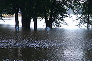
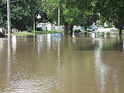
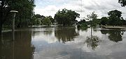
The 2007 Midwest flooding was a major flood
ing event that occurred in the Midwestern United States
in the third week of August 2007. While Hurricane Dean
was affecting the Yucatán Peninsula
and the Gulf of Mexico
, and Tropical Storm Erin
was affecting Oklahoma
and Texas
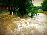
, a persistent storm system hung over the Midwest for several days, causing repeated flash flood
ing in the U.S. state
s of Illinois
, Indiana
, Iowa
, Minnesota
, Ohio
, and Wisconsin
. Cool Canadian air clashed with large quantities of warm moist air from the Gulf, producing torrential rains along a stationary front
. Eighteen deaths across the central United States
were attributed to the resulting flooding. Twenty-one counties in Minnesota, Ohio and Wisconsin, and six counties in Illinois were declared Federal Disaster Areas.
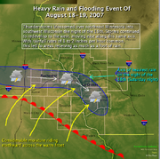 On Saturday, August 18, a warm front
pushed northward into Iowa and Illinois, where it became stationary
. Warm, moist air pushing over the frontal boundary fueled showers and thunderstorms that moved in a west-to-east fashion, training
over the same areas for hours at a time. Some parts of Minnesota, Wisconsin and Iowa saw moderate to heavy rain for nearly a full day before the activity finally cleared out. Additional thunderstorms formed over these areas on Sunday, August 19, exacerbating the flooding problems. Tropical Storm Erin had pushed into the coast of Texas on August 15, and by August 18 had stalled over Oklahoma. Though the remnants of Erin did not directly impact the flooding in these areas, moisture from Erin streamed northward, enhancing the thunderstorm activity for two to three days.
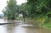
The stationary front and associated energy then extended eastward through Illinois, Indiana and Ohio on August 19 and August 20. Similarly, the front was the focus for thunderstorm development, and the precipitation continued moving over the same areas, leading to extended periods of heavy rainfall. Approximately 1,000,000 homes lost electricity due to the storms.
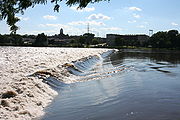
Runoff from the heavy rain also caused river flooding to the south of the affected areas. The Rock River near Joslin, Illinois peaked at 17.11 feet, 5.11 feet (1.56 m) above flood stage. Moderate flooding was also reported on the Mississippi River
from the Quad Cities
to St. Louis, Missouri
.
 The city of Rockford, Illinois
was deluged in the weeks preceding the major flooding during the third week of August. On August 7, 2007, Rockford was hit by five to seven inches (127–178 mm) of rain. Many streets, including main thoroughfares, were flooded. There was also fear that the Alpine Dam might break. The following day, Governor Rod Blagojevich
declared both Rockford and Winnebago County
a state disaster area. With this declaration, he dispatched both the Illinois Emergency Management Agency and the Illinois Department of Natural Resources
to assist the city. Debris removal, law enforcement, damage assessment, and other physical assistance were offered by the governor.
 About two weeks later on August 23, violent storms rolled through the Chicago area. A Tornado Warning was issued for all of Chicago during the first storm and a tornado touched down in Winfield. The second storm was more rain and lightning. Governor Rod Blagojevich
declared McHenry
, Lake
, Cook
(including Chicago), DuPage
, and Kane
counties to be disaster areas after the storm. Though not affected by flooding as it was on August 7, the city of Rockford received 1.23 inches (31 mm) of rain, setting an all time record for Rockford's wettest month in recorded climate data history, with a total of 13.82 inches (351 mm) of rain. The storm shut down airports (including O'Hare International Airport
and Midway International Airport), uprooted trees and left over 600,000 residents in northern Illinois without power, some for several days. It also caused flooding on streets and major expressways shuch as the Bishop Ford Freeway
. Wind gusts registered as high as 80 miles per hour (130 km/h) in the area, with the highest being reported in Manhattan
. A small tornado was also reported in Bolingbrook
in a DuPage County
Forest Preserve. Rainfall totals in Boone and LaSalle Counties topped 1987 records. Flooding across northern Illinois was widespread in the aftermath of the storms. Along the Rock River in Byron
, the river reached moderate flood stage on August 24; moderate stage is above 14 feet (4 m). Officials in Ogle County
recommended that people in low-lying areas along the Rock River, and along Killbuck Creek
near Lindenwood
, evacuate to higher ground. Downstream, in Lee County at Dixon
, the river had not reached flood stage as off August 25, though it continued to rise.
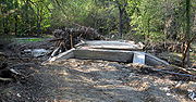
 Other rivers and streams in the Rock River valley experienced moderate to major flooding as well. The Kishwaukee River
at Perryville crested at 17.57 feet (5.36 m), more than five feet above flood stage. The same river also rose above flood stage in Belvidere
. After 4.85 inches (123 mm) of rain fell on August 23 and 24 in DeKalb County
, at DeKalb
, the South Branch Kishwaukee River
rose to its highest level since 1983 and its second highest level in recorded history. Numerous roads and bridges were closed, and the cities of DeKalb and Sycamore
declared local emergencies, though DeKalb County was not included in Blagojevich's initial disaster declaration. DeKalb County received state disaster area designation from Blagojevich on August 26. In DeKalb and Sycamore, about 600 residents were displaced from their homes, and the DeKalb campus of Northern Illinois University
was closed because of the flood.
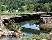
 The Fox River
at Dayton crested after it rose to more than 17 feet (5 m), over five feet above the river's flood stage. In Plano, Illinois
the Fox rose up around the historic Farnsworth House, a modern architecture masterpiece designed by Ludwig Mies van der Rohe
. Preservationists used a boat to save the home and its furnishings, which previously had been devastated by high water in 1996. With the boat, preservationists were able to enter the house and move vulnerable furnishings to higher locations within the home. Water rose to within a foot of the Farnsworth House's raised platform, covering the terrace
in front of the home, but the river crested before any damage occurred. At Starved Rock State Park
, parking lots were closed due to the level of the Illinois River
, which stood at 26.5 feet on August 25, 6.5 feet (2 m) above its flood stage.
Governor Blagojevich estimated total flood damages could cost nine Illinois counties and the state more than $22.8 million, and the state requested federal assistance. On September 25, the Federal Emergency Management Agency
(FEMA) announced that federal disaster aid was available for the state of Illinois to assist with recovery from the August storms. The disaster aid was made available when President George W. Bush declared DeKalb
, Grundy, Kane
, LaSalle, Lake
, and Will
Counties, in northern Illinois, "major disaster" areas. The federal funding made individual assistance available to flood victims in Lake, Will and Grundy Counties, and individual and public assistance available to those in DeKalb, Kane and LaSalle Counties.
, southeast of Chicago, authorities evacuated 70 patients from St. Margaret Mercy Hospital after a waters from a nearby creek started seeping into the hospital. Also in northwest Indiana, a section of Interstate 80
/94
(Borman Expressway
) was closed on August 24 due to flooding on the roadway. It was reopened on August 27.
near Fort Dodge
crested at 4 feet (1.2 m) above flood stage, necessitating the evacuation of three subdivisions. In Ottumwa
, storm sewers backed up into the city's water treatment
plant, shutting four pumps down and leaving the entire town without adequate drinking water. This was caused by rainfall of over 12 inches (304.8 mm) that fell in southeast Iowa during the night of August 23–24. August 24 damage estimates in nearby Boone County, Iowa
reached $150,000 in road damage and an additional $1 million damage to a scenic railroad.
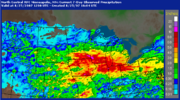
 A large swath of heavy rain fell across most of southern Minnesota during Saturday, August 18, and Sunday, August 19, with the highest totals in the far southeast counties
of the state. Twenty-four hour rainfall totals of 15.10 inches (384 mm) were recorded in Hokah
, which easily broke the old state record of 10.84 inches (275 mm). An unofficial twenty-four hour total of over 17 inches (432 mm) was recorded near Caledonia
. During the entire weekend rainfall event, parts or all of 28 counties in Minnesota received at least 4 inches (102 mm) of rain. The highest total for the entire event was 18.17 inches (462 mm) near La Crescent
.
 Southeast Minnesota
and southwestern Wisconsin are in the Driftless Area, which was not covered by the last glaciation, and therefore is not covered by deep layers of glacial till. The soils therefore are thin and less able to retain water; they lie atop porous rock into and through which surface waters can rapidly drain into the water table. The highly dissected topography, characterized by steep hills and bluffs and deep coulee
s, gives steep gradients to the drainage and makes streams highly erosive. As the rains far exceeded the absorption rate of 1.5 inches (3.8 cm) in six hours, flash floods rapidly overflowed the water courses and spread across the valley floors. The towns of Stockton
, Houston
, Elba
, Minnesota City
, and portions of Winona
, on the Mississippi River
, were evacuated. Citizens were moved to Saint Mary's University
in Winona, Lewiston
, and Caledonia, Minnesota
. Massive bluffs gave way in Brownsville and several homes were completely washed away. Governor Tim Pawlenty
ordered 240 National Guard soldiers to help and declared a state of emergency in six counties. The Minnesota Army National Guard
soldiers guarded communities that were cleared out after the flooding early August 19. The Army Corps of Engineers opened up the floodgates on the rising Root River
to release some of the water creating pressure on the dike in Houston.
 High flood waters on the Middle Branch of the Whitewater River
, which runs through Whitewater State Park
, destroyed three bridges and damaged campgrounds, bathhouses, a group dining hall, and water and sewer systems in the park. About 500 campers were staying in Whitewater State Park at the time. The park was closed to the public on August 20, 2007, for an indefinite period of time. E. coli
bacteria were found in the Rushford
's water supply, and residents were urged not to use it until the city's water system could be flushed.
 Amtrak
train service between Minneapolis and La Crosse, Wisconsin
was shut down for a week because of damage to the tracks. Passengers were bussed between the two until repairs could be made. The passenger rail line resumed service on August 27.
State Senator Sharon Erickson Ropes
stated after initial flooding, "This is the worst disaster that's hit southeast Minnesota in a lifetime." Four thousand two hundred homes were damaged or destroyed in the state, and seven deaths were reported. It is estimated that there has been $67 million in damage. Dodge
, Fillmore
, Houston
, Olmsted
, Steele
, Wabasha
, and Winona
counties were declared federal
disaster area
s.
 The Blanchard River
was 7.5 feet (2 m) above flood level in Findlay
, the highest level since 1913. A 92-year-old man drowned trying to get to safety after his car became trapped in floodwater near Findlay
, where water poured into the downtown area from the Blanchard and its tributary creeks. One hundred thirty inmates were moved from a Hancock County
jail. Bucyrus
received 9 inches (229 mm) of rain, and several hundred people were evacuated from their homes in Crawford County
. The river also reached 8.7 feet (3 m) above flood level in Ottawa, Ohio
. Ottawa's Main Street (U.S Route 224) was fully flooded, as were homes and churches for blocks around. Between Findlay and Ottawa, Route 224 was washed out in several spots. The fire department in Ottawa rescued dozens of people from their deluged homes by boat.
Northwest Ohio's most serious flooding was along the Blanchard, though other rivers, including the Auglaize
, Tiffin
, Portage
, and Sandusky
, all experienced some level of flooding. The cities of Bellevue
and Shelby
also had severe flooding that forced residents from their homes. Allen
, Crawford
, Hancock
, Putnam
, Richland
, and Wyandot
counties were declared federal
disaster area
s.
 In Wisconsin, Governor Jim Doyle
declared a state of emergency on August 20 in three counties in the southwest corner of his state after weekend rains of ten to twelve inches fell. (254–305 mm). More than 200 homes were flooded in the Crawford County communities of Gays Mills
and Soldiers Grove
, each with about 600 to 640 residents. A mudslide pushed one house onto state Highway 35 in Vernon County
. Approximately $48 million in damage was reported in 12 Wisconsin counties. Crawford, La Crosse, Richland, Sauk
, and Vernon
counties were declared federal
disaster area
s.
In Madison
, a mother and daughter waiting for a Madison Metro
bus were electrocuted
when lightning
struck a power line
and caused it to fall onto a flooded street on which they were standing, while another child was injured. A passenger on the bus was killed, and the driver was injured, both having been shocked after coming out of the bus to help.
Before this torrential rain and flooding event, much of the state was in a moderate to severe drought that had persisted until mid-August. Although the southern half of the state received abundant precipitation, an upper-level high pressure ridge centered in Quebec
caused a cut-off of precipitation to the north, leaving much of northern Wisconsin and Upper Michigan
with continued drought conditions.
Flood
A flood is an overflow of an expanse of water that submerges land. The EU Floods directive defines a flood as a temporary covering by water of land not normally covered by water...
ing event that occurred in the Midwestern United States
Midwestern United States
The Midwestern United States is one of the four U.S. geographic regions defined by the United States Census Bureau, providing an official definition of the American Midwest....
in the third week of August 2007. While Hurricane Dean
Hurricane Dean
The name Dean was used for five tropical cyclones in the Northern Atlantic Ocean:*1983's Tropical Storm Dean, which struck the coast of Virginia, causing minor erosion and flooding...
was affecting the Yucatán Peninsula
Yucatán Peninsula
The Yucatán Peninsula, in southeastern Mexico, separates the Caribbean Sea from the Gulf of Mexico, with the northern coastline on the Yucatán Channel...
and the Gulf of Mexico
Gulf of Mexico
The Gulf of Mexico is a partially landlocked ocean basin largely surrounded by the North American continent and the island of Cuba. It is bounded on the northeast, north and northwest by the Gulf Coast of the United States, on the southwest and south by Mexico, and on the southeast by Cuba. In...
, and Tropical Storm Erin
Tropical Storm Erin (2007)
Tropical Storm Erin was the second tropical cyclone to make landfall in the United States in the 2007 Atlantic hurricane season. The fifth named storm of the season, it formed in the Gulf of Mexico on August 14 from a persistent area of convection...
was affecting Oklahoma
Oklahoma
Oklahoma is a state located in the South Central region of the United States of America. With an estimated 3,751,351 residents as of the 2010 census and a land area of 68,667 square miles , Oklahoma is the 28th most populous and 20th-largest state...
and Texas
Texas
Texas is the second largest U.S. state by both area and population, and the largest state by area in the contiguous United States.The name, based on the Caddo word "Tejas" meaning "friends" or "allies", was applied by the Spanish to the Caddo themselves and to the region of their settlement in...
, a persistent storm system hung over the Midwest for several days, causing repeated flash flood
Flash flood
A flash flood is a rapid flooding of geomorphic low-lying areas—washes, rivers, dry lakes and basins. It may be caused by heavy rain associated with a storm, hurricane, or tropical storm or meltwater from ice or snow flowing over ice sheets or snowfields...
ing in the U.S. state
U.S. state
A U.S. state is any one of the 50 federated states of the United States of America that share sovereignty with the federal government. Because of this shared sovereignty, an American is a citizen both of the federal entity and of his or her state of domicile. Four states use the official title of...
s of Illinois
Illinois
Illinois is the fifth-most populous state of the United States of America, and is often noted for being a microcosm of the entire country. With Chicago in the northeast, small industrial cities and great agricultural productivity in central and northern Illinois, and natural resources like coal,...
, Indiana
Indiana
Indiana is a US state, admitted to the United States as the 19th on December 11, 1816. It is located in the Midwestern United States and Great Lakes Region. With 6,483,802 residents, the state is ranked 15th in population and 16th in population density. Indiana is ranked 38th in land area and is...
, Iowa
Iowa
Iowa is a state located in the Midwestern United States, an area often referred to as the "American Heartland". It derives its name from the Ioway people, one of the many American Indian tribes that occupied the state at the time of European exploration. Iowa was a part of the French colony of New...
, Minnesota
Minnesota
Minnesota is a U.S. state located in the Midwestern United States. The twelfth largest state of the U.S., it is the twenty-first most populous, with 5.3 million residents. Minnesota was carved out of the eastern half of the Minnesota Territory and admitted to the Union as the thirty-second state...
, Ohio
Ohio
Ohio is a Midwestern state in the United States. The 34th largest state by area in the U.S.,it is the 7th‑most populous with over 11.5 million residents, containing several major American cities and seven metropolitan areas with populations of 500,000 or more.The state's capital is Columbus...
, and Wisconsin
Wisconsin
Wisconsin is a U.S. state located in the north-central United States and is part of the Midwest. It is bordered by Minnesota to the west, Iowa to the southwest, Illinois to the south, Lake Michigan to the east, Michigan to the northeast, and Lake Superior to the north. Wisconsin's capital is...
. Cool Canadian air clashed with large quantities of warm moist air from the Gulf, producing torrential rains along a stationary front
Stationary front
A stationary front is a boundary between two different air masses, neither of which is strong enough to replace the other. On a weather map, this is shown by an inter-playing series of blue spikes pointing one direction and red domes pointing the other. They tend to remain essentially in the same...
. Eighteen deaths across the central United States
Central United States
The Central United States is sometimes conceived as between the Eastern United States and Western United States as part of a three-region model, roughly coincident with the Midwestern United States plus the western and central portions of the Southern United States; the term is also sometimes used...
were attributed to the resulting flooding. Twenty-one counties in Minnesota, Ohio and Wisconsin, and six counties in Illinois were declared Federal Disaster Areas.
Meteorological synopsis
Warm front
A warm front is a density discontinuity located at the leading edge of a homogeneous warm air mass, and is typically located on the equator-facing edge of an isotherm gradient...
pushed northward into Iowa and Illinois, where it became stationary
Stationary front
A stationary front is a boundary between two different air masses, neither of which is strong enough to replace the other. On a weather map, this is shown by an inter-playing series of blue spikes pointing one direction and red domes pointing the other. They tend to remain essentially in the same...
. Warm, moist air pushing over the frontal boundary fueled showers and thunderstorms that moved in a west-to-east fashion, training
Training (meteorology)
In meteorology, training denotes repeated areas of rain, typically associated with thunderstorms, that move over the same region in a relatively short period of time. Training thunderstorms are capable of producing excessive rainfall totals, often causing flash flooding...
over the same areas for hours at a time. Some parts of Minnesota, Wisconsin and Iowa saw moderate to heavy rain for nearly a full day before the activity finally cleared out. Additional thunderstorms formed over these areas on Sunday, August 19, exacerbating the flooding problems. Tropical Storm Erin had pushed into the coast of Texas on August 15, and by August 18 had stalled over Oklahoma. Though the remnants of Erin did not directly impact the flooding in these areas, moisture from Erin streamed northward, enhancing the thunderstorm activity for two to three days.
The stationary front and associated energy then extended eastward through Illinois, Indiana and Ohio on August 19 and August 20. Similarly, the front was the focus for thunderstorm development, and the precipitation continued moving over the same areas, leading to extended periods of heavy rainfall. Approximately 1,000,000 homes lost electricity due to the storms.
Runoff from the heavy rain also caused river flooding to the south of the affected areas. The Rock River near Joslin, Illinois peaked at 17.11 feet, 5.11 feet (1.56 m) above flood stage. Moderate flooding was also reported on the Mississippi River
Mississippi River
The Mississippi River is the largest river system in North America. Flowing entirely in the United States, this river rises in western Minnesota and meanders slowly southwards for to the Mississippi River Delta at the Gulf of Mexico. With its many tributaries, the Mississippi's watershed drains...
from the Quad Cities
Quad Cities
The Quad Cities is a group of five cities straddling the Mississippi River on the Iowa–Illinois boundary. These cities, Davenport and Bettendorf and Rock Island, Moline, and East Moline , are the center of the Quad Cities Metropolitan Area, which, as of 2010, had an estimated population of...
to St. Louis, Missouri
St. Louis, Missouri
St. Louis is an independent city on the eastern border of Missouri, United States. With a population of 319,294, it was the 58th-largest U.S. city at the 2010 U.S. Census. The Greater St...
.
| Summary of Casualties and Damage | |||
|---|---|---|---|
| State | Counties affected | Fatalities | Estimated Damage |
| Illinois Illinois Illinois is the fifth-most populous state of the United States of America, and is often noted for being a microcosm of the entire country. With Chicago in the northeast, small industrial cities and great agricultural productivity in central and northern Illinois, and natural resources like coal,... |
7 | 2 | $22.8 million |
| Indiana Indiana Indiana is a US state, admitted to the United States as the 19th on December 11, 1816. It is located in the Midwestern United States and Great Lakes Region. With 6,483,802 residents, the state is ranked 15th in population and 16th in population density. Indiana is ranked 38th in land area and is... |
1 | 0 | $5 million |
| Iowa Iowa Iowa is a state located in the Midwestern United States, an area often referred to as the "American Heartland". It derives its name from the Ioway people, one of the many American Indian tribes that occupied the state at the time of European exploration. Iowa was a part of the French colony of New... |
1 | $8 million | |
| Minnesota Minnesota Minnesota is a U.S. state located in the Midwestern United States. The twelfth largest state of the U.S., it is the twenty-first most populous, with 5.3 million residents. Minnesota was carved out of the eastern half of the Minnesota Territory and admitted to the Union as the thirty-second state... |
7 | 7 | $179 million |
| Ohio Ohio Ohio is a Midwestern state in the United States. The 34th largest state by area in the U.S.,it is the 7th‑most populous with over 11.5 million residents, containing several major American cities and seven metropolitan areas with populations of 500,000 or more.The state's capital is Columbus... |
6 | 1 | $241 million |
| Wisconsin Wisconsin Wisconsin is a U.S. state located in the north-central United States and is part of the Midwest. It is bordered by Minnesota to the west, Iowa to the southwest, Illinois to the south, Lake Michigan to the east, Michigan to the northeast, and Lake Superior to the north. Wisconsin's capital is... |
5 | 3 | $93 million |
Tornadoes reported
Illinois
Rockford, Illinois
Rockford is a mid-sized city located on both banks of the Rock River in far northern Illinois. Often referred to as "The Forest City", Rockford is the county seat of Winnebago County, Illinois, USA. As reported in the 2010 U.S. census, the city was home to 152,871 people, the third most populated...
was deluged in the weeks preceding the major flooding during the third week of August. On August 7, 2007, Rockford was hit by five to seven inches (127–178 mm) of rain. Many streets, including main thoroughfares, were flooded. There was also fear that the Alpine Dam might break. The following day, Governor Rod Blagojevich
Rod Blagojevich
Rod R. Blagojevich is an American politician who served as the 40th Governor of Illinois from 2003 to 2009. A Democrat, Blagojevich was a State Representative before being elected to the United States House of Representatives representing parts of Chicago...
declared both Rockford and Winnebago County
Winnebago County, Illinois
Winnebago County is a county located in the U.S. state of Illinois. According to the 2010 census, it has a population of 295,266, which is an increase of 6.1% from 278,418 in 2000...
a state disaster area. With this declaration, he dispatched both the Illinois Emergency Management Agency and the Illinois Department of Natural Resources
Illinois Department of Natural Resources
The Illinois Department of Natural Resources is a cabinet-level department of the state government of Illinois. It is headquartered in the state capital of Springfield...
to assist the city. Debris removal, law enforcement, damage assessment, and other physical assistance were offered by the governor.
Rod Blagojevich
Rod R. Blagojevich is an American politician who served as the 40th Governor of Illinois from 2003 to 2009. A Democrat, Blagojevich was a State Representative before being elected to the United States House of Representatives representing parts of Chicago...
declared McHenry
McHenry County, Illinois
McHenry County is a county located in the U.S. state of Illinois. According to the 2010 census, it has a population of 308,760, which is an increase of 18.7% from 260,077 in 2000. Its county seat is Woodstock. This county is part of the Chicago metropolitan area. It is the sixth largest county, in...
, Lake
Lake County, Illinois
Lake County is a county in the northeastern corner of the state of Illinois, on the shore of Lake Michigan. According to the 2010 census, it has a population of 703,462, which is an increase of 9.2% from 644,356 in 2000. Its county seat is Waukegan. The county is part of the Chicago metropolitan area...
, Cook
Cook County, Illinois
Cook County is a county in the U.S. state of Illinois, with its county seat in Chicago. It is the second most populous county in the United States after Los Angeles County. The county has 5,194,675 residents, which is 40.5 percent of all Illinois residents. Cook County's population is larger than...
(including Chicago), DuPage
DuPage County, Illinois
As of the 2010 Census, the population of the county was 916,924, White Americans made up 77.9% of Dupage County's population; non-Hispanic whites represented 70.5% of the population. Black Americans made up 4.6% of the population. Native Americans made up 0.3% of Dupage County's population...
, and Kane
Kane County, Illinois
Kane County is a county located in the U.S. state of Illinois. According to the 2010 census, it has a population of 515,269, which is an increase of 27.5% from 404,119 in 2000. Its county seat is Geneva, and its largest city is Aurora.- Geography :...
counties to be disaster areas after the storm. Though not affected by flooding as it was on August 7, the city of Rockford received 1.23 inches (31 mm) of rain, setting an all time record for Rockford's wettest month in recorded climate data history, with a total of 13.82 inches (351 mm) of rain. The storm shut down airports (including O'Hare International Airport
O'Hare International Airport
Chicago O'Hare International Airport , also known as O'Hare Airport, O'Hare Field, Chicago Airport, Chicago International Airport, or simply O'Hare, is a major airport located in the northwestern-most corner of Chicago, Illinois, United States, northwest of the Chicago Loop...
and Midway International Airport), uprooted trees and left over 600,000 residents in northern Illinois without power, some for several days. It also caused flooding on streets and major expressways shuch as the Bishop Ford Freeway
Bishop Ford Freeway
The Bishop Ford Freeway, formerly known as the Calumet Expressway, is a portion of Interstate 94 in northeastern Illinois, south of downtown Chicago. It runs from Interstate 57 south to the intersection with Interstate 80, Interstate 294 and Illinois Route 394...
. Wind gusts registered as high as 80 miles per hour (130 km/h) in the area, with the highest being reported in Manhattan
Manhattan, Illinois
Manhattan is a village in Will County, Illinois, United States. The population was 6,071 at the 2006 special census. The city is located in northeastern Illinois approximately 50 miles southwest of Chicago.- History :...
. A small tornado was also reported in Bolingbrook
Bolingbrook, Illinois
Bolingbrook is a large village in Will and DuPage Counties in the U.S. state of Illinois. As of the 2010 US Census, the population is 73,366...
in a DuPage County
DuPage County, Illinois
As of the 2010 Census, the population of the county was 916,924, White Americans made up 77.9% of Dupage County's population; non-Hispanic whites represented 70.5% of the population. Black Americans made up 4.6% of the population. Native Americans made up 0.3% of Dupage County's population...
Forest Preserve. Rainfall totals in Boone and LaSalle Counties topped 1987 records. Flooding across northern Illinois was widespread in the aftermath of the storms. Along the Rock River in Byron
Byron, Illinois
Byron is a city in Ogle County, Illinois, United States, probably best known as the location of the Byron Nuclear Generating Station, one of the last nuclear power plants commissioned in the United States. Byron is located in Byron Township, along the Rock River. The population was 3,753 at the...
, the river reached moderate flood stage on August 24; moderate stage is above 14 feet (4 m). Officials in Ogle County
Ogle County, Illinois
Ogle County is a county located in the U.S. state of Illinois. According to the 2010 census, it has a population of 53,497, which is an increase of 4.8% from 51,032 in 2000. Its county seat is Oregon, and its largest city is Rochelle...
recommended that people in low-lying areas along the Rock River, and along Killbuck Creek
Killbuck Creek (Kishwaukee River)
Killbuck Creek is a tributary of the Kishwaukee River in northern Illinois, United States.-Course:The creek runs north through southeastern Ogle County, where it cuts through Galena limestone and blue limestone. The Killbuck passes through Pine Rock Township, where a stone quarry was once located...
near Lindenwood
Lindenwood, Illinois
Lindenwood is an unincorporated community in Ogle County, Illinois, and is located north of Rochelle, along the banks of the Kilbuck Creek.-Geography:...
, evacuate to higher ground. Downstream, in Lee County at Dixon
Dixon, Illinois
Dixon is a city in Lee County, Illinois, United States. The population was 15,733 as of the 2010 census, down from 15,941 at the 2000 census. Named for its founder, John Dixon , it is the county seat of Lee County. Located on the Rock River, Dixon was the boyhood home of former U.S...
, the river had not reached flood stage as off August 25, though it continued to rise.
Kishwaukee River
The Kishwaukee River, sometimes locally known as simply "The Kish", is a river in the U.S. state of Illinois. "The Kish" is famous for its high number of bridges that cross within its 100-year floodplain.-Location:...
at Perryville crested at 17.57 feet (5.36 m), more than five feet above flood stage. The same river also rose above flood stage in Belvidere
Belvidere, Illinois
Belvidere is a city in Boone County, Illinois, United States. The population was 25,585 as of the 2010 census. It is the county seat of Boone County. Belvidere is part of the Rockford, Illinois Metropolitan Statistical Area.-Geography:...
. After 4.85 inches (123 mm) of rain fell on August 23 and 24 in DeKalb County
DeKalb County, Illinois
DeKalb County is a county located in the U.S. state of Illinois. According to the 2010 census, it has a population of 105,160, which is an increase of 18.2% from 88,969 in 2000. Its county seat is Sycamore. DeKalb County is part of the Chicago metropolitan statistical area.-History:DeKalb County...
, at DeKalb
DeKalb, Illinois
DeKalb is a city in DeKalb County, Illinois, United States. The population was 43,862 at the 2010 census, up from 39,018 at the 2000 census. The city is named after decorated German war hero Johann De Kalb, who died during the American Revolutionary War....
, the South Branch Kishwaukee River
South Branch Kishwaukee River
The South Branch Kishwaukee River is a tributary of the Kishwaukee River in northern Illinois. The South Branch is the main branch of the Kishwaukee River, joining it above its confluence with the Rock River...
rose to its highest level since 1983 and its second highest level in recorded history. Numerous roads and bridges were closed, and the cities of DeKalb and Sycamore
Sycamore, Illinois
Sycamore is a city in DeKalb County, Illinois, United States. It has a commercial district based and centered on Illinois Route 64. The population was 17,519 at the 2010 census, up from 12,020 at the 2000 census.-Early settlement:...
declared local emergencies, though DeKalb County was not included in Blagojevich's initial disaster declaration. DeKalb County received state disaster area designation from Blagojevich on August 26. In DeKalb and Sycamore, about 600 residents were displaced from their homes, and the DeKalb campus of Northern Illinois University
Northern Illinois University
Northern Illinois University is a state university and research institution located in DeKalb, Illinois, with satellite centers in Hoffman Estates, Naperville, Rockford, and Oregon. It was originally founded as Northern Illinois State Normal School on May 22, 1895 by Illinois Governor John P...
was closed because of the flood.
Fox River (Illinois River tributary)
The Fox River is a tributary of the Illinois River in the states of Wisconsin and Illinois in the United States. There are two other "Fox Rivers" in southern Illinois: the Fox River and a smaller "Fox River" that joins the Wabash River near New Harmony, Indiana.-Wisconsin:The Fox River rises near...
at Dayton crested after it rose to more than 17 feet (5 m), over five feet above the river's flood stage. In Plano, Illinois
Plano, Illinois
Plano is a city in Kendall County, Illinois, United States near Aurora, with a population of 5,633 at the 2000 census. The city is rapidly growing with new subdivisions such as Lakewood Springs completed and several other developments under construction or in the planning stages. Former Speaker...
the Fox rose up around the historic Farnsworth House, a modern architecture masterpiece designed by Ludwig Mies van der Rohe
Ludwig Mies van der Rohe
Ludwig Mies van der Rohe was a German architect. He is commonly referred to and addressed as Mies, his surname....
. Preservationists used a boat to save the home and its furnishings, which previously had been devastated by high water in 1996. With the boat, preservationists were able to enter the house and move vulnerable furnishings to higher locations within the home. Water rose to within a foot of the Farnsworth House's raised platform, covering the terrace
Terrace (building)
A terrace is an outdoor, occupiable extension of a building above ground level. Although its physical characteristics may vary to a great degree, a terrace will generally be larger than a balcony and will have an "open-top" facing the sky...
in front of the home, but the river crested before any damage occurred. At Starved Rock State Park
Starved Rock State Park
Starved Rock State Park is a state park in Illinois, characterized by the many canyons within its 2360 acres. Located just southwest of the village of North Utica, in Deer Park Township, LaSalle County, Illinois, along the south bank of the Illinois River, the park hosts over two million visitors...
, parking lots were closed due to the level of the Illinois River
Illinois River
The Illinois River is a principal tributary of the Mississippi River, approximately long, in the State of Illinois. The river drains a large section of central Illinois, with a drainage basin of . This river was important among Native Americans and early French traders as the principal water route...
, which stood at 26.5 feet on August 25, 6.5 feet (2 m) above its flood stage.
Governor Blagojevich estimated total flood damages could cost nine Illinois counties and the state more than $22.8 million, and the state requested federal assistance. On September 25, the Federal Emergency Management Agency
Federal Emergency Management Agency
The Federal Emergency Management Agency is an agency of the United States Department of Homeland Security, initially created by Presidential Reorganization Plan No. 1 of 1978 and implemented by two Executive Orders...
(FEMA) announced that federal disaster aid was available for the state of Illinois to assist with recovery from the August storms. The disaster aid was made available when President George W. Bush declared DeKalb
DeKalb County, Illinois
DeKalb County is a county located in the U.S. state of Illinois. According to the 2010 census, it has a population of 105,160, which is an increase of 18.2% from 88,969 in 2000. Its county seat is Sycamore. DeKalb County is part of the Chicago metropolitan statistical area.-History:DeKalb County...
, Grundy, Kane
Kane County, Illinois
Kane County is a county located in the U.S. state of Illinois. According to the 2010 census, it has a population of 515,269, which is an increase of 27.5% from 404,119 in 2000. Its county seat is Geneva, and its largest city is Aurora.- Geography :...
, LaSalle, Lake
Lake County, Illinois
Lake County is a county in the northeastern corner of the state of Illinois, on the shore of Lake Michigan. According to the 2010 census, it has a population of 703,462, which is an increase of 9.2% from 644,356 in 2000. Its county seat is Waukegan. The county is part of the Chicago metropolitan area...
, and Will
Will County, Illinois
As of the census of 2000, there were 502,266 people, 167,542 households, and 131,017 families residing in the county. The population density was 600 people per square mile . There were 175,524 housing units at an average density of 210 per square mile...
Counties, in northern Illinois, "major disaster" areas. The federal funding made individual assistance available to flood victims in Lake, Will and Grundy Counties, and individual and public assistance available to those in DeKalb, Kane and LaSalle Counties.
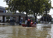
Indiana
In Dyer, IndianaDyer, Indiana
As of the census of 2010, there were 16,390 people residing in the town. The population density was 2,731.67 people per square mile . There were 6,125 housing units at an average density of 1,020.83 per square mile...
, southeast of Chicago, authorities evacuated 70 patients from St. Margaret Mercy Hospital after a waters from a nearby creek started seeping into the hospital. Also in northwest Indiana, a section of Interstate 80
Interstate 80
Interstate 80 is the second-longest Interstate Highway in the United States, following Interstate 90. It is a transcontinental artery running from downtown San Francisco, California to Teaneck, New Jersey in the New York City Metropolitan Area...
/94
Interstate 94
Interstate 94 is the northernmost east–west Interstate Highway, connecting the Great Lakes and Intermountain regions of the United States. I-94's western terminus is in Billings, Montana at a junction with Interstate 90; its eastern terminus is the U.S...
(Borman Expressway
Borman Expressway
The Frank Borman Expressway is an east–west highway in the northwest part of the U.S. state of Indiana, named after astronaut and former Eastern Airlines CEO Frank Borman. The expressway consists of parts of Interstate 80 , I-94, and U.S. Highway 6 , as well as a short section of US 41...
) was closed on August 24 due to flooding on the roadway. It was reopened on August 27.
Iowa
The Des Moines RiverDes Moines River
The Des Moines River is a tributary river of the Mississippi River, approximately long to its farther headwaters, in the upper Midwestern United States...
near Fort Dodge
Fort Dodge, Iowa
Fort Dodge is a city and county seat of Webster County, Iowa, United States, along the Des Moines River. The population was 25,206 in the 2010 census, an increase from 25,136 in the 2000 census. Fort Dodge is a major commercial center for North Central and Northwest Iowa. It is located on U.S...
crested at 4 feet (1.2 m) above flood stage, necessitating the evacuation of three subdivisions. In Ottumwa
Ottumwa, Iowa
Ottumwa is a city in and the county seat of Wapello County, Iowa, United States. The population was 24,998 at the 2000 census. It is located in the southeastern part of Iowa, and the city is split into northern and southern halves by the Des Moines River....
, storm sewers backed up into the city's water treatment
Water treatment
Water treatment describes those processes used to make water more acceptable for a desired end-use. These can include use as drinking water, industrial processes, medical and many other uses. The goal of all water treatment process is to remove existing contaminants in the water, or reduce the...
plant, shutting four pumps down and leaving the entire town without adequate drinking water. This was caused by rainfall of over 12 inches (304.8 mm) that fell in southeast Iowa during the night of August 23–24. August 24 damage estimates in nearby Boone County, Iowa
Boone County, Iowa
-2010 census:The 2010 census recorded a population of 26,306 in the county, with a population density of . There were 11,756 housing units, of which 10,728 were occupied.-2000 census:...
reached $150,000 in road damage and an additional $1 million damage to a scenic railroad.
Minnesota
Southeast Minnesota
Southeast Minnesota is the corner of Minnesota south of the Twin Cities metropolitan area extending east, and part of the multi-state area known as the Driftless Area. Rochester is the largest city in the area; other major cities include Winona, Owatonna, Faribault, Northfield, Austin, and Red...
of the state. Twenty-four hour rainfall totals of 15.10 inches (384 mm) were recorded in Hokah
Hokah, Minnesota
Hokah is a city in Houston County, Minnesota, United States. The population was 580 at the 2010 census.-Geography:According to the United States Census Bureau, the city has a total area of , of which, of it is land and 1.37% is water.-Transportation:...
, which easily broke the old state record of 10.84 inches (275 mm). An unofficial twenty-four hour total of over 17 inches (432 mm) was recorded near Caledonia
Caledonia, Minnesota
As of the census of 2000, there were 2,965 people, 1,223 households, and 754 families residing in the city. The population density was 1,037.1 people per square mile . There were 1,286 housing units at an average density of 449.8 per square mile...
. During the entire weekend rainfall event, parts or all of 28 counties in Minnesota received at least 4 inches (102 mm) of rain. The highest total for the entire event was 18.17 inches (462 mm) near La Crescent
La Crescent, Minnesota
As of the census of 2000, there were 4,923 people, 1,940 households, and 1,367 families residing in the city. The population density was 1,634.4 people per square mile . There were 2,014 housing units at an average density of 668.6 per square mile...
.
Southeast Minnesota
Southeast Minnesota is the corner of Minnesota south of the Twin Cities metropolitan area extending east, and part of the multi-state area known as the Driftless Area. Rochester is the largest city in the area; other major cities include Winona, Owatonna, Faribault, Northfield, Austin, and Red...
and southwestern Wisconsin are in the Driftless Area, which was not covered by the last glaciation, and therefore is not covered by deep layers of glacial till. The soils therefore are thin and less able to retain water; they lie atop porous rock into and through which surface waters can rapidly drain into the water table. The highly dissected topography, characterized by steep hills and bluffs and deep coulee
Coulee
Coulee is applied rather loosely to different landforms, all of which refer to a kind of valley or drainage zone.The word coulee comes from the Canadian French coulée, from French word couler meaning "to flow"....
s, gives steep gradients to the drainage and makes streams highly erosive. As the rains far exceeded the absorption rate of 1.5 inches (3.8 cm) in six hours, flash floods rapidly overflowed the water courses and spread across the valley floors. The towns of Stockton
Stockton, Minnesota
Stockton is a city in Winona County, Minnesota, United States. The population was 697 at the 2010 census.-Geography:According to the United States Census Bureau, the city has a total area of , all of it land....
, Houston
Houston, Minnesota
Houston is a city in Houston County, Minnesota, United States. The population was 979 at the 2010 census.-History:The community was named after Sam Houston, first president of the Republic of Texas....
, Elba
Elba, Minnesota
Elba is a city in Winona County, Minnesota, United States. The population was 152 at the 2010 census. It is on Minnesota State Highway 74 just north of Whitewater State Park.-Geography:...
, Minnesota City
Minnesota City, Minnesota
Minnesota City is a city in Winona County, Minnesota, United States. The population was 204 at the 2010 census.-Geography:According to the United States Census Bureau, the city has a total area of , all of it land.-Demographics:...
, and portions of Winona
Winona, Minnesota
Winona is a city in and the county seat of Winona County, in the U.S. State of Minnesota. Located in picturesque bluff country on the Mississippi River, its most noticeable physical landmark is Sugar Loaf....
, on the Mississippi River
Mississippi River
The Mississippi River is the largest river system in North America. Flowing entirely in the United States, this river rises in western Minnesota and meanders slowly southwards for to the Mississippi River Delta at the Gulf of Mexico. With its many tributaries, the Mississippi's watershed drains...
, were evacuated. Citizens were moved to Saint Mary's University
Saint Mary's University of Minnesota
Saint Mary's University of Minnesota is a private, comprehensive, coeducational university with an undergraduate campus in the city of Winona, Minnesota, United States...
in Winona, Lewiston
Lewiston, Minnesota
Lewiston is a city in Winona County, Minnesota, United States. The population was 1,620 at the 2010 census.-Geography:According to the United States Census Bureau, the city has a total area of , all of it land....
, and Caledonia, Minnesota
Caledonia, Minnesota
As of the census of 2000, there were 2,965 people, 1,223 households, and 754 families residing in the city. The population density was 1,037.1 people per square mile . There were 1,286 housing units at an average density of 449.8 per square mile...
. Massive bluffs gave way in Brownsville and several homes were completely washed away. Governor Tim Pawlenty
Tim Pawlenty
Timothy James "Tim" Pawlenty , also known affectionately among supporters as T-Paw, is an American politician who served as the 39th Governor of Minnesota . He was a Republican candidate for President of the United States in the 2012 election from May to August 2011...
ordered 240 National Guard soldiers to help and declared a state of emergency in six counties. The Minnesota Army National Guard
Minnesota Army National Guard
The Minnesota Army National Guard, along with the Minnesota Air National Guard, is an element of the Minnesota National Guard. The Constitution of the United States specifically charges the National Guard with dual federal and state missions. In fact, the National Guard is the only United States...
soldiers guarded communities that were cleared out after the flooding early August 19. The Army Corps of Engineers opened up the floodgates on the rising Root River
Root River (Minnesota)
The Root River flows for through the Driftless Area of southeastern Minnesota and is a tributary of the Upper Mississippi River. It is an excellent river for canoeing...
to release some of the water creating pressure on the dike in Houston.
Whitewater River (Minnesota)
The Whitewater River is a tributary of the Upper Mississippi River which flows through the Driftless Area of Minnesota, reaching its mouth in Winona County opposite Buffalo, Wisconsin. The nearest towns are Altura, Saint Charles, and Elba...
, which runs through Whitewater State Park
Whitewater State Park
Whitewater State Park is a Minnesota state park in Winona County in the southeastern blufflands area of the state. The park features scenic overlooks and excellent trout fishing in the spring fed Whitewater River and Trout Run Creek. It has about 300,000 visitors annually, and is located 7 miles ...
, destroyed three bridges and damaged campgrounds, bathhouses, a group dining hall, and water and sewer systems in the park. About 500 campers were staying in Whitewater State Park at the time. The park was closed to the public on August 20, 2007, for an indefinite period of time. E. coli
Escherichia coli
Escherichia coli is a Gram-negative, rod-shaped bacterium that is commonly found in the lower intestine of warm-blooded organisms . Most E. coli strains are harmless, but some serotypes can cause serious food poisoning in humans, and are occasionally responsible for product recalls...
bacteria were found in the Rushford
Rushford, Minnesota
As of the census of 2000, there are 1,696 people, 704 households, and 433 families residing in the city. The population density is 988.5 people per square mile . There are 761 housing units at an average density of 443.6 per square mile...
's water supply, and residents were urged not to use it until the city's water system could be flushed.
Amtrak
The National Railroad Passenger Corporation, doing business as Amtrak , is a government-owned corporation that was organized on May 1, 1971, to provide intercity passenger train service in the United States. "Amtrak" is a portmanteau of the words "America" and "track". It is headquartered at Union...
train service between Minneapolis and La Crosse, Wisconsin
La Crosse, Wisconsin
La Crosse is a city in and the county seat of La Crosse County, Wisconsin, United States. The city lies alongside the Mississippi River.The 2011 Census Bureau estimates the city had a population of 52,485...
was shut down for a week because of damage to the tracks. Passengers were bussed between the two until repairs could be made. The passenger rail line resumed service on August 27.
State Senator Sharon Erickson Ropes
Sharon Erickson Ropes
Sharon L. Erickson Ropes is a Minnesota politician and a former member of the Minnesota Senate who represented District 31, which includes portions of Fillmore, Houston, and Winona counties in the southeastern part of the state. A Democrat, she was first elected to the Senate in 2006...
stated after initial flooding, "This is the worst disaster that's hit southeast Minnesota in a lifetime." Four thousand two hundred homes were damaged or destroyed in the state, and seven deaths were reported. It is estimated that there has been $67 million in damage. Dodge
Dodge County, Minnesota
As of the census of 2000, there were 17,731 people, 6,420 households, and 4,853 families residing in the county. The population density was 40 people per square mile . There were 6,642 housing units at an average density of 15 per square mile...
, Fillmore
Fillmore County, Minnesota
As of the census of 2000, there were 21,122 people, 8,228 households, and 5,718 families residing in the county. The population density was 24 people per square mile . There were 8,908 housing units at an average density of 10 per square mile...
, Houston
Houston County, Minnesota
As of the census of 2000, there were 19,718 people, 7,633 households, and 5,411 families residing in the county. The population density was 35 people per square mile . There were 8,168 housing units at an average density of 15 per square mile...
, Olmsted
Olmsted County, Minnesota
As of the census of 2000, there were 124,277 people, 47,807 households, and 32,317 families residing in the county. The population density was 190 people per square mile . There were 49,422 housing units at an average density of 76 per square mile...
, Steele
Steele County, Minnesota
As of the census of 2000, there were 33,680 people, 12,846 households, and 9,082 families residing in the county. The population density was 78 people per square mile . There were 13,306 housing units at an average density of 31 per square mile...
, Wabasha
Wabasha County, Minnesota
As of the census of 2000, there were 21,610 people, 8,277 households, and 5,876 families residing in the county. The population density was 41 people per square mile . There were 9,066 housing units at an average density of 17 per square mile...
, and Winona
Winona County, Minnesota
As of the census of 2000, there were 49,985 people, 18,744 households, and 11,696 families residing in the county. The population density was 80 people per square mile . There were 19,551 housing units at an average density of 31 per square mile...
counties were declared federal
Federal government of the United States
The federal government of the United States is the national government of the constitutional republic of fifty states that is the United States of America. The federal government comprises three distinct branches of government: a legislative, an executive and a judiciary. These branches and...
disaster area
Disaster area
A disaster area is a region or a locale heavily damaged by either natural hazards, such as tornadoes, hurricanes, tsunamis, floods, earthquakes, technological hazards including nuclear and radiation accidents, or sociological hazards like riots, terrorism or war. The population living there often...
s.
Ohio
Blanchard River (Ohio)
The Blanchard River is a tributary of the Auglaize River in northwestern Ohio in the United States. It drains a primarily rural farming area in the watershed of Lake Erie....
was 7.5 feet (2 m) above flood level in Findlay
Findlay, Ohio
As of the census of 2000, there were 38,967 people, 15,905 households, and 10,004 families residing in the city. The population density was 2,266.3 people per square mile . There were 17,152 housing units at an average density of 997.6 per square mile...
, the highest level since 1913. A 92-year-old man drowned trying to get to safety after his car became trapped in floodwater near Findlay
Findlay, Ohio
As of the census of 2000, there were 38,967 people, 15,905 households, and 10,004 families residing in the city. The population density was 2,266.3 people per square mile . There were 17,152 housing units at an average density of 997.6 per square mile...
, where water poured into the downtown area from the Blanchard and its tributary creeks. One hundred thirty inmates were moved from a Hancock County
Hancock County, Ohio
Hancock County is a county located in the state of Ohio, United States. As of the 2010 census, the population was 74,782. Its county seat is Findlay and was named for John Hancock, the first signer of the Declaration of Independence...
jail. Bucyrus
Bucyrus, Ohio
As of the census of 2000, there were 13,224 people, 5,559 households, and 3,552 families residing in the city. The population density was 1,812.0 people per square mile . There were 5,955 housing units at an average density of 816.0 per square mile...
received 9 inches (229 mm) of rain, and several hundred people were evacuated from their homes in Crawford County
Crawford County, Ohio
Crawford County is a county located in the state of Ohio, United States. It was named for Colonel William Crawford, a soldier during the American Revolution....
. The river also reached 8.7 feet (3 m) above flood level in Ottawa, Ohio
Ottawa, Ohio
Ottawa is a village in and the county seat of Putnam County, Ohio, United States. The population was 4,460 at the 2010 census.-History:In 1792 Major Alexander Truman, his servant William Lynch and guide/interpreter William Smalley were sent by George Washington on a peace mission...
. Ottawa's Main Street (U.S Route 224) was fully flooded, as were homes and churches for blocks around. Between Findlay and Ottawa, Route 224 was washed out in several spots. The fire department in Ottawa rescued dozens of people from their deluged homes by boat.
Northwest Ohio's most serious flooding was along the Blanchard, though other rivers, including the Auglaize
Auglaize River
The Auglaize River is a tributary of the Maumee River in northwestern Ohio in the United States. It drains a primarily rural farming area in the watershed of Lake Erie. The name of the river either comes from a Shawnee phrase meaning "fallen timbers" or a French term for "frozen water."It rises in...
, Tiffin
Tiffin River
The Tiffin River is a tributary of the Maumee River in northwestern Ohio in the United States. Headwater tributaries of the river rise in southeastern Michigan. The river drains a primarily rural farming region in the watershed of Lake Erie. Early French traders called the river Crique Féve,...
, Portage
Portage River (Ohio)
Approximately in length, the Portage River meanders across Ottawa, Sandusky, and Wood counties in northwest Ohio before it empties into Lake Erie at Port Clinton...
, and Sandusky
Sandusky River
The Sandusky River is a tributary to Lake Erie in north-central Ohio in the United States. It is about long and flows into Lake Erie at Sandusky Bay.-Course:...
, all experienced some level of flooding. The cities of Bellevue
Bellevue, Ohio
Bellevue is a city in Erie, Huron, Sandusky and Seneca counties in the U.S. state of Ohio. The population was 8,193 at the 2000 census. The National Arbor Day Foundation has designated Bellevue as a Tree City USA....
and Shelby
Shelby, Ohio
Shelby is a city in Richland County in the U.S. state of Ohio, northwest of the city of Mansfield. It is part of the Mansfield, Ohio Metropolitan Statistical Area. The population was 9,821 at the 2000 census.-History:...
also had severe flooding that forced residents from their homes. Allen
Allen County, Ohio
Allen County is a county located in the U.S. state of Ohio. Its population was 106,331 as of the 2010 census. It is included in the Lima, Ohio Metropolitan Statistical Area as well as the Lima–Van Wert–Wapakoneta Combined Statistical Area....
, Crawford
Crawford County, Ohio
Crawford County is a county located in the state of Ohio, United States. It was named for Colonel William Crawford, a soldier during the American Revolution....
, Hancock
Hancock County, Ohio
Hancock County is a county located in the state of Ohio, United States. As of the 2010 census, the population was 74,782. Its county seat is Findlay and was named for John Hancock, the first signer of the Declaration of Independence...
, Putnam
Putnam County, Ohio
Putnam County is a county located in the state of Ohio, United States. As of the 2010 census, the population was 34,499. The name is in honor of Israel Putnam, who was a hero in the French and Indian War and a general in the American Revolutionary War. Its county seat is...
, Richland
Richland County, Ohio
Richland County is a county located in the state of Ohio, United States. As of the 2010 census, the population was 124,475. It is included in the Mansfield, Ohio, Metropolitan Statistical Area as well as the Mansfield–Bucyrus Combined Statistical Area....
, and Wyandot
Wyandot County, Ohio
As of the census of 2000, there were 22,908 people, 8,882 households, and 6,270 families residing in the county. The population density was 56 people per square mile . There were 9,324 housing units at an average density of 23 per square mile...
counties were declared federal
Federal government of the United States
The federal government of the United States is the national government of the constitutional republic of fifty states that is the United States of America. The federal government comprises three distinct branches of government: a legislative, an executive and a judiciary. These branches and...
disaster area
Disaster area
A disaster area is a region or a locale heavily damaged by either natural hazards, such as tornadoes, hurricanes, tsunamis, floods, earthquakes, technological hazards including nuclear and radiation accidents, or sociological hazards like riots, terrorism or war. The population living there often...
s.
Wisconsin
Jim Doyle
James Edward "Jim" Doyle is a Wisconsin politician and member of the Democratic Party. He was the 44th Governor of Wisconsin, serving from January 6, 2003 to January 3, 2011. He defeated incumbent Governor Scott McCallum by a margin of 45 percent to 41 percent; the Libertarian Party candidate Ed...
declared a state of emergency on August 20 in three counties in the southwest corner of his state after weekend rains of ten to twelve inches fell. (254–305 mm). More than 200 homes were flooded in the Crawford County communities of Gays Mills
Gays Mills, Wisconsin
Gays Mills is a village in Crawford County, Wisconsin, United States. The population was 625 at the 2000 census.- History :In 1847 James B. Gay, a native of Indiana, built a dam and a sawmill on the Kickapoo River, which proved to be a flourishing success. When his health started to fail, James...
and Soldiers Grove
Soldiers Grove, Wisconsin
Soldiers Grove is a village located alongside the Kickapoo River in Crawford County, Wisconsin, in the United States. As of the 2000 census, the village population was 653.-Claim to fame:...
, each with about 600 to 640 residents. A mudslide pushed one house onto state Highway 35 in Vernon County
Vernon County, Wisconsin
Vernon County is a county in the U.S. state of Wisconsin. As of 2009, the population estimate was 29,324. Its county seat is Viroqua.-History:...
. Approximately $48 million in damage was reported in 12 Wisconsin counties. Crawford, La Crosse, Richland, Sauk
Sauk County, Wisconsin
Sauk County is a county in the U.S. state of Wisconsin. As of 2000, the population was 55,225. Its county seat and largest city is Baraboo. Sauk County is included in the Baraboo Micropolitan Statistical Area and in the Madison Combined Statistical Area....
, and Vernon
Vernon County, Wisconsin
Vernon County is a county in the U.S. state of Wisconsin. As of 2009, the population estimate was 29,324. Its county seat is Viroqua.-History:...
counties were declared federal
Federal government of the United States
The federal government of the United States is the national government of the constitutional republic of fifty states that is the United States of America. The federal government comprises three distinct branches of government: a legislative, an executive and a judiciary. These branches and...
disaster area
Disaster area
A disaster area is a region or a locale heavily damaged by either natural hazards, such as tornadoes, hurricanes, tsunamis, floods, earthquakes, technological hazards including nuclear and radiation accidents, or sociological hazards like riots, terrorism or war. The population living there often...
s.
In Madison
Madison, Wisconsin
Madison is the capital of the U.S. state of Wisconsin and the county seat of Dane County. It is also home to the University of Wisconsin–Madison....
, a mother and daughter waiting for a Madison Metro
Madison Metro
Madison Metro Transit operates extensive bus service throughout the city of Madison, Wisconsin and to the surrounding communities of Middleton, Fitchburg, and Verona. Systemwide, fixed route ridership was 13.4 million in 2008...
bus were electrocuted
Electric shock
Electric Shock of a body with any source of electricity that causes a sufficient current through the skin, muscles or hair. Typically, the expression is used to denote an unwanted exposure to electricity, hence the effects are considered undesirable....
when lightning
Lightning
Lightning is an atmospheric electrostatic discharge accompanied by thunder, which typically occurs during thunderstorms, and sometimes during volcanic eruptions or dust storms...
struck a power line
Electric power transmission
Electric-power transmission is the bulk transfer of electrical energy, from generating power plants to Electrical substations located near demand centers...
and caused it to fall onto a flooded street on which they were standing, while another child was injured. A passenger on the bus was killed, and the driver was injured, both having been shocked after coming out of the bus to help.
Before this torrential rain and flooding event, much of the state was in a moderate to severe drought that had persisted until mid-August. Although the southern half of the state received abundant precipitation, an upper-level high pressure ridge centered in Quebec
Quebec
Quebec or is a province in east-central Canada. It is the only Canadian province with a predominantly French-speaking population and the only one whose sole official language is French at the provincial level....
caused a cut-off of precipitation to the north, leaving much of northern Wisconsin and Upper Michigan
Upper Peninsula of Michigan
The Upper Peninsula of Michigan is the northern of the two major land masses that make up the U.S. state of Michigan. It is commonly referred to as the Upper Peninsula, the U.P., or Upper Michigan. It is also known as the land "above the Bridge" linking the two peninsulas. The peninsula is bounded...
with continued drought conditions.
See also
- Floods in the United States: 2001-presentFloods in the United States: 2001-presentFloods in the United States: since 2001 is a list of significant floods which have struck the United States since 2001. Floods are generally caused by excessive rainfall, excessive snowmelt, storm surge from hurricanes, and dam failure...
- List of Minnesota weather records
- Tropical Storm ErinTropical Storm Erin (2007)Tropical Storm Erin was the second tropical cyclone to make landfall in the United States in the 2007 Atlantic hurricane season. The fifth named storm of the season, it formed in the Gulf of Mexico on August 14 from a persistent area of convection...
External links
- Amateur video of a flash flood in a residential area – Minneapolis Star Tribune
- Flooding at the Farnsworth House, Landmarks Preservation Council of IllinoisLandmarks Preservation Council of IllinoisThe Landmarks Preservation Council of Illinois -- also known as Landmarks Illinois -- is a not-for-profit organization founded in 1971 to prevent the demolition of the Dankmar Adler and Louis Sullivan designed Chicago Stock Exchange Building...
, includes photo slide show. - Rainfall totals & prediction – Advanced Hydrologic Prediction Service