

List of Minnesota weather records
Encyclopedia
The following is a list of Minnesota weather records observed
at various stations across the state during the last 130 years. Minnesota
is a state
in the Upper Midwest
ern region of the United States
. Due to its location in the northern plains of the United States its climate
is one of extremes. Minnesota's history of nearly continuous meteorological
record keeping stretches back nearly two centuries to 1819 when Fort Snelling
was settled. By 1871 the first official government
observations were taking place in the Twin Cities and by the early 20th century most state-wide stations that exist today were in operation.
 Record flood stages for selected cities in Minnesota
Large-scale events that affected Minnesota
Surface weather observation
Surface weather observations are the fundamental data used for safety as well as climatological reasons to forecast weather and issue warnings worldwide. They can be taken manually, by a weather observer, by computer through the use of automated weather stations, or in a hybrid scheme using...
at various stations across the state during the last 130 years. Minnesota
Minnesota
Minnesota is a U.S. state located in the Midwestern United States. The twelfth largest state of the U.S., it is the twenty-first most populous, with 5.3 million residents. Minnesota was carved out of the eastern half of the Minnesota Territory and admitted to the Union as the thirty-second state...
is a state
U.S. state
A U.S. state is any one of the 50 federated states of the United States of America that share sovereignty with the federal government. Because of this shared sovereignty, an American is a citizen both of the federal entity and of his or her state of domicile. Four states use the official title of...
in the Upper Midwest
Upper Midwest
The Upper Midwest is a region in the northern portion of the U.S. Census Bureau's Midwestern United States. It is largely a sub-region of the midwest. Although there are no uniformly agreed-upon boundaries, the region is most commonly used to refer to the states of Minnesota, Wisconsin, and...
ern region of the United States
United States
The United States of America is a federal constitutional republic comprising fifty states and a federal district...
. Due to its location in the northern plains of the United States its climate
Climate of Minnesota
The climate of Minnesota is typical of a continental climate, with cold winters and hot summers. Minnesota's location in the Upper Midwest allows it to experience some of the widest variety of weather in the United States, with each of the four seasons having its own distinct characteristics...
is one of extremes. Minnesota's history of nearly continuous meteorological
Meteorology
Meteorology is the interdisciplinary scientific study of the atmosphere. Studies in the field stretch back millennia, though significant progress in meteorology did not occur until the 18th century. The 19th century saw breakthroughs occur after observing networks developed across several countries...
record keeping stretches back nearly two centuries to 1819 when Fort Snelling
Fort Snelling, Minnesota
Fort Snelling, originally known as Fort Saint Anthony, was a military fortification located at the confluence of the Minnesota River and Mississippi River in Hennepin County, Minnesota...
was settled. By 1871 the first official government
Federal government of the United States
The federal government of the United States is the national government of the constitutional republic of fifty states that is the United States of America. The federal government comprises three distinct branches of government: a legislative, an executive and a judiciary. These branches and...
observations were taking place in the Twin Cities and by the early 20th century most state-wide stations that exist today were in operation.
Overall
| Event | Measurement | Date | Location |
|---|---|---|---|
| Highest Temperature Temperature Temperature is a physical property of matter that quantitatively expresses the common notions of hot and cold. Objects of low temperature are cold, while various degrees of higher temperatures are referred to as warm or hot... |
114 °F (46 °C) | July 29, 1917 July 6, 1936 |
Beardsley Beardsley, Minnesota Beardsley is a city in Big Stone County, Minnesota, United States. The population was 233 at the 2010 census.Beardsley holds two state monthly record high temperatures, 111°F in September, set in 1931, and 98°F Beardsley is a city in Big Stone County, Minnesota, United States. The population was... Moorhead Moorhead, Minnesota Moorhead is a city in Clay County, Minnesota, United States, and the largest city in northwest Minnesota. The population was 38,065 at the 2010 Census. It is the county seat of Clay County.... |
| Lowest Temperature | -60 °F | February 1996 | Embarrass Tower Tower, Minnesota As of the census of 2000, there are 479 people in the city, organized into 233 households and 137 families. The population density is 176.8 people per square mile . There are 295 housing units at an average density of 108.9 per square mile... |
| Largest single-day change | 71 °F drop (39 °C) | April 3, 1982 | Lamberton Lamberton, Minnesota Lamberton is a city in Redwood County, Minnesota, United States. The population was 824 at the 2010 census.-Geography:According to the United States Census Bureau, the city has a total area of , all of it land.Lamberton is located along U.S... |
By month
| Event | Measurement | Date | Location |
|---|---|---|---|
| January | |||
| Highest Temperature | 69 °F (21 °C) | January 24, 1981 | Montevideo Montevideo, Minnesota As of the census of 2000, there were 5,346 people, 2,353 households, and 1,444 families residing in the city. The population density was 1,190.5 people per square mile . There were 2,551 housing units at an average density of 568.1 per square mile... |
| Lowest Temperature | -57 °F | January 24, 1904 January 21, 1996 January 22, 1996 |
Pokegama Dam Embarrass Embarrass |
| February | |||
| Highest Temperature | 73 °F (23 °C) | February 26, 1896 | Pleasant Mound Pleasant Mound Township, Minnesota Pleasant Mound Township is a township in Blue Earth County, Minnesota, United States. The population was 235 as of the 2000 census.-Geography:... |
| Lowest Temperature | -60 °F | February 2, 1996 | Tower |
| March | |||
| Highest Temperature | 88 °F (31 °C) | March 23, 1910 | Montevideo |
| Lowest Temperature | -50 °F | March 2, 1897 | Pokegama Dam |
| April | |||
| Highest Temperature | 101 °F (38 °C) | April 22, 1980 | Hawley Hawley, Minnesota As of the census of 2000, there were 1,882 people, 744 households, and 514 families residing in the city. The population density was 764.8 people per square mile . There were 787 housing units at an average density of 319.8 per square mile... |
| Lowest Temperature | -22 °F | April 6, 1979 | Karlstad Karlstad, Minnesota As of the census of 2000, there were 794 people, 340 households, and 199 families residing in the city. The population density was 522.3 people per square mile . There were 394 housing units at an average density of 259.2 per square mile . The racial makeup of the city was 97.86% White, 0.63%... |
| May | |||
| Highest Temperature | 112 °F (44 °C) | May 31, 1934 | Maple Plain Maple Plain, Minnesota As of the census of 2000, there were 2,088 people, 770 households, and 536 families residing in the city. The population density was 1,875.4 people per square mile . There were 786 housing units at an average density of 706.0 per square mile... |
| Lowest Temperature | 4 °F (-16 °C) | May 1, 1909 May 2, 1909 |
Pine River Pine River, Minnesota As of the census of 2000, there were 928 people, 438 households, and 216 families residing in the city. The population density was 834.6 people per square mile . There were 464 housing units at an average density of 417.3 per square mile... Pine River |
| June | |||
| Highest Temperature | 110 °F (43 °C) | June 29, 1931 | Canby Canby, Minnesota As of the census of 2000, there are 1,903 people, 842 households, and 453 families residing in the city. The population density is 876.5 people per square mile . There are 918 housing units at an average density of 422.8 per square mile... |
| Lowest Temperature | 15 °F (-9 °C) | June 1, 1964 | Bigfork Bigfork, Minnesota Bigfork is a city in Itasca County, Minnesota, United States. The population was 446 at the 2010 census. Scenic State Park is nearby.Minnesota State Highway 38 serves as a main route in the community... |
| July | |||
| Highest Temperature | 114 °F (46 °C) | July 29, 1917 July 6, 1936 |
Beardsley Moorhead |
| Lowest Temperature | 24 °F (-4 °C) | July 7, 1997 | Tower |
| August | |||
| Highest Temperature | 110 °F (43 °C) | August 10, 1947 August 1, 1988 |
Beardsley Montevideo |
| Lowest Temperature | 21 °F (-6 °C) | August 28, 1996 August 2, 2002 |
Tower Kelliher Kelliher, Minnesota Kelliher is a city in Beltrami County, Minnesota, United States. The population was 262 at the 2010 census.-Geography:According to the United States Census Bureau, the city has a total area of , of which, of it is land and of it is water.... |
| September | |||
| Highest Temperature | 111 °F (44 °C) | September 11, 1931 | Beardsley |
| Lowest Temperature | 10 °F (-12 °C) | September 30, 1930 September 22, 1974 |
Big Falls Big Falls, Minnesota Big Falls is a city in Koochiching County, Minnesota, United States. The population was 236 at the 2010 census.-Geography:According to the United States Census Bureau, the city has a total area of , all land.U.S... Thorhult |
| October | |||
| Highest Temperature | 98 °F (37 °C) | October 5, 1963 | Beardsley |
| Lowest Temperature | -16 °F | October 26, 1936 | Roseau Roseau, Minnesota As of the census of 2000, there were 2,756 people, 1,157 households, and 713 families residing in the city. The population density was 1,153.6 people per square mile . There were 1,229 housing units at an average density of 514.4 per square mile... |
| November | |||
| Highest Temperature | 84 °F (29 °C) | November 1, 1950 | Winona Winona, Minnesota Winona is a city in and the county seat of Winona County, in the U.S. State of Minnesota. Located in picturesque bluff country on the Mississippi River, its most noticeable physical landmark is Sugar Loaf.... |
| Lowest Temperature | -45 °F | November 30, 1896 | Pokegama Dam |
| December | |||
| Highest Temperature | 74 °F (23 °C) | December 9, 1939 | Wheaton Wheaton, Minnesota As of the census of 2000, there were 1,619 people, 747 households, and 434 families residing in the city. The population density was 909.2 people per square mile . There were 907 housing units at an average density of 509.4 per square mile... |
| Lowest Temperature | -57 °F | December 31, 1898 | Pokegama Dam |
Precipitation
| Event | Measurement | Date | Location |
|---|---|---|---|
| Most yearly precip Precipitation (meteorology) In meteorology, precipitation In meteorology, precipitation In meteorology, precipitation (also known as one of the classes of hydrometeors, which are atmospheric water phenomena is any product of the condensation of atmospheric water vapor that falls under gravity. The main forms of precipitation... (one location) |
53.52 inches (1,359 mm) | 1991 | St. Francis St. Francis, Minnesota As of the census of 2009, there were 7,298 people, 1,638 households, and 1,300 families residing in the city. The population density was 210.6 people per square mile . There were 1,686 housing units at an average density of 72.3 per square mile... |
| Least yearly precip (one location) | 6.37 inches (162 mm) | 1976 | Ortonville Ortonville, Minnesota As of the census of 2000, there were 2,158 people, 923 households, and 594 families residing in the city. The population density was 635.8 people per square mile . There were 1,125 housing units at an average density of 331.4 per square mile... |
| Most yearly precip Precipitation (meteorology) In meteorology, precipitation In meteorology, precipitation In meteorology, precipitation (also known as one of the classes of hydrometeors, which are atmospheric water phenomena is any product of the condensation of atmospheric water vapor that falls under gravity. The main forms of precipitation... (State average) |
33.92 inches (862 mm) | 1977 | State wide |
| Longest dryspell Drought A drought is an extended period of months or years when a region notes a deficiency in its water supply. Generally, this occurs when a region receives consistently below average precipitation. It can have a substantial impact on the ecosystem and agriculture of the affected region... |
79 days | November 9, 1943 - January 26, 1944 |
Beardsley, Canby, Marshall, Dawson Dawson, Minnesota As of the census of 2000, there were 1,539 people, 677 households, and 398 families residing in the city. The population density was 1,043.4 people per square mile . There were 756 housing units at an average density of 512.6 per square mile... |
Rain
| Event | Measurement | Date | Location |
|---|---|---|---|
| Most rain Rain Rain is liquid precipitation, as opposed to non-liquid kinds of precipitation such as snow, hail and sleet. Rain requires the presence of a thick layer of the atmosphere to have temperatures above the melting point of water near and above the Earth's surface... in 24 hours |
15.1 inches (384 mm) | August 18 – August 19, 2007 | Hokah Hokah, Minnesota Hokah is a city in Houston County, Minnesota, United States. The population was 580 at the 2010 census.-Geography:According to the United States Census Bureau, the city has a total area of , of which, of it is land and 1.37% is water.-Transportation:... |
| Most rain in one month | 23.86 inches (606 mm) | August, 2007 | Hokah |
Snow
| Event | Measurement | Date | Location |
|---|---|---|---|
| Earliest recorded snow Snow Snow is a form of precipitation within the Earth's atmosphere in the form of crystalline water ice, consisting of a multitude of snowflakes that fall from clouds. Since snow is composed of small ice particles, it is a granular material. It has an open and therefore soft structure, unless packed by... |
Trace | August 31, 1949 | Duluth |
| Earliest measurable snow | 0.3 inch (1 cm) | September 14, 1964 | International Falls |
| Latest recorded snow | 1.5 inches (4 cm) | June 4, 1935 | Mizpah Mizpah, Minnesota Mizpah is a city in Koochiching County, Minnesota, United States. Its population was 56 at the 2010 census. The name is the Hebrew word for "watchtower."... |
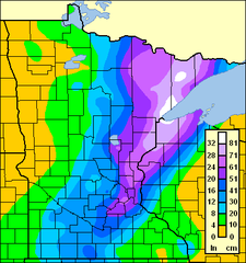
| Most snow, 24 hours | 36 inches (91 cm) | January 7, 1994 | Lake County Lake County, Minnesota Lake County is a county located in the U.S. state of Minnesota. As of 2010, the population was 10,866. Its county seat is Two Harbors. Lake County was founded on February 20, 1855, as Superior County, though its name was changed on March 3, of that year to St. Louis County. On March 1, 1856, St... |
| Most snow, one storm Winter storm A winter storm is an event in which the dominant varieties of precipitation are formed that only occur at low temperatures, such as snow or sleet, or a rainstorm where ground temperatures are low enough to allow ice to form... |
47 inches (119 cm) | January 6–8, 1994 | Lake County |
| Most snow, one month | 66 inches (168 cm) | March, 1965 | Collegeville |
| Most snow, season | 170 inches (432 cm) | 1949 – 1950 | Grand Portage State Park Grand Portage State Park Grand Portage State Park is a state park at the northeastern tip of Minnesota, USA, on the Canada – United States border. It contains a waterfall, the tallest in the state, on the Pigeon River. The High Falls and other waterfalls and rapids upstream necessitated a historically important portage... |
| Largest snow cover | 88 inches (224 cm) | February 21, 1969 | Meadowlands |
| Most fatalities, winter storm | up to 200 Schoolhouse Blizzard The Schoolhouse Blizzard, also known as the Schoolchildren's Blizzard or the Children's Blizzard, hit the U.S. plains states on January 12, 1888... |
January 12–13, 1888 | State-wide |
Tornadoes
| Event | Date | Location | |
|---|---|---|---|
| Most in one day | 48 | June 17, 2010 | State-wide |
| Most in one month | 71 | June, 2010 | State-wide |
| Most in one year | 113 | 2010 | State-wide |
| Earliest in season | March 18, 1968 | Truman Truman, Minnesota As of the census of 2000, there were 1,259 people, 510 households, and 318 families residing in the city. The population density was 1,160.1 people per square mile . There were 542 housing units at an average density of 499.4 per square mile... |
|
| Earliest outbreak in season (2 or more) | 14 | March 29, 1998 | Southern Minnesota |
| Latest in season | November 16, 1931 | Maple Plain | |
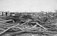
| Most fatalities, single tornado Tornado A tornado is a violent, dangerous, rotating column of air that is in contact with both the surface of the earth and a cumulonimbus cloud or, in rare cases, the base of a cumulus cloud. They are often referred to as a twister or a cyclone, although the word cyclone is used in meteorology in a wider... |
72 | April 14, 1886 | St. Cloud St. Cloud, Minnesota St. Cloud is a city in the U.S. state of Minnesota and the largest population center in the state's central region. The population was 65,842 at the 2010 census. It is the county seat of Stearns County... , Sauk Rapids Sauk Rapids, Minnesota As of the census of 2000, there were 10,213 people, 3,921 households, and 2,599 families residing in the city. The population density was 2,234.1 people per square mile . There were 4,017 housing units at an average density of 878.7 per square mile... , Rice Rice, Minnesota As of the census of 2000, there were 711 people, 247 households, and 185 families residing in the city. The population density was 118.8 people per square mile . There were 250 housing units at an average density of 41.8 per square mile . The racial makeup of the city was 98.87% White, 0.70% Native... |
| Most intense damage measured | F5 Fujita scale The Fujita scale , or Fujita-Pearson scale, is a scale for rating tornado intensity, based primarily on the damage tornadoes inflict on human-built structures and vegetation... |
June 13, 1968 June 16, 1992 |
Tracy Tracy, Minnesota As of the census of 2000, there were 2,268 people, 922 households, and 533 families residing in the city. The population density was 1,045.2 people per square mile . There were 1,013 housing units at an average density of 466.8 per square mile... Chandler Chandler, Minnesota As of the census of 2000, there were 276 people, 113 households, and 72 families residing in the city. The population density was 342.7 people per square mile . There were 121 housing units at an average density of 150.2 per square mile . The racial makeup of the city was 97.46% White, 1.81%... |
| Longest track (broken path) |
110 miles (177 km) | August 26, 1977 | Otter Tail, Wadena, Cass, Crow Wing counties |
| Longest track (continuous path) |
67 miles (108 km) | March 29, 1998 | Murray, Cottonwood, Brown, Watonwan, Blue Earth, Nicollet counties |
| Biggest outbreak | 48 | Mid-June 2010 tornado outbreak Mid-June 2010 tornado outbreak -June 16 event:-June 17 event:-June 18 event:-Wadena supercell:Around 3:20 p.m. CDT , a supercell thunderstorm developed over Stevens County, Minnesota and initially tracked north-northeastward before turning fully northeast... |
State-wide |
Hail
| Event | Measurement | Date | Location |
|---|---|---|---|
| Largest hail Hail Hail is a form of solid precipitation. It consists of balls or irregular lumps of ice, each of which is referred to as a hail stone. Hail stones on Earth consist mostly of water ice and measure between and in diameter, with the larger stones coming from severe thunderstorms... stone |
6 inches (15 cm) dia. Diameter In geometry, a diameter of a circle is any straight line segment that passes through the center of the circle and whose endpoints are on the circle. The diameters are the longest chords of the circle... |
July 4, 1968 July 28, 1986 |
Edgerton Edgerton, Minnesota As of the census of 2000, there were 1,033 people, 435 households, and 287 families residing in the city. The population density was 890.2 people per square mile . There were 477 housing units at an average density of 411.1 per square mile . The racial makeup of the city was 98.84% White, 0.29%... Reading Reading, Minnesota Reading is an unincorporated community in Nobles County, Minnesota, United States.-Geography:Reading is northwest of Worthington. According to A.P Rose's History of Nobles County, Reading is nearer to the geographic center of the county than any other community... |
Flooding
| Event | Measurement | Date | Location |
|---|---|---|---|
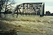
| Middle Fork, Whitewater River Whitewater River (Minnesota) The Whitewater River is a tributary of the Upper Mississippi River which flows through the Driftless Area of Minnesota, reaching its mouth in Winona County opposite Buffalo, Wisconsin. The nearest towns are Altura, Saint Charles, and Elba... |
|||
| Highest flood stage Flood stage Flood stage is the level at which the surface of a river, creek, or other body of water has risen to a sufficient level to cause damage or affects use of man-made structures... |
19.24 ft | August 19, 2007 | Whitewater State Park Whitewater State Park Whitewater State Park is a Minnesota state park in Winona County in the southeastern blufflands area of the state. The park features scenic overlooks and excellent trout fishing in the spring fed Whitewater River and Trout Run Creek. It has about 300,000 visitors annually, and is located 7 miles ... |
| Root River Root River (Minnesota) The Root River flows for through the Driftless Area of southeastern Minnesota and is a tributary of the Upper Mississippi River. It is an excellent river for canoeing... |
|||
| Highest flood stage | 18.75 ft | August 19, 2007 | Houston Houston, Minnesota Houston is a city in Houston County, Minnesota, United States. The population was 979 at the 2010 census.-History:The community was named after Sam Houston, first president of the Republic of Texas.... |
| Red River of the North | |||
| Highest flood stage | 40.82 ft | March 28, 2009 | Moorhead |
| Highest flood stage | 54.35 ft | April 22, 1997 | East Grand Forks |
| Minnesota River | |||
| Highest flood stage | 23.90 ft | April 6, 1997 | Montevideo |
| Highest flood stage | 35.07 ft | April 12, 1965 | Jordan Jordan, Minnesota Jordan is a city in Scott County, Minnesota, United States. The population was 5,470 at the 2010 census.-Geography:According to the United States Census Bureau, the city has a total area of , of which, of it is land and of it is water. U.S. Highway 169; and State Highways 21 and 282 are three... |
| Mississippi River | |||
| Highest flood stage | 26.01 ft | April 16, 1965 | St. Paul |
| Highest flood stage | 20.77 ft | April 19, 1965 | Winona |
Other records
over Minnesota| Event | Measurement | Date | Location |
|---|---|---|---|
| Highest Pressure Atmospheric pressure Atmospheric pressure is the force per unit area exerted into a surface by the weight of air above that surface in the atmosphere of Earth . In most circumstances atmospheric pressure is closely approximated by the hydrostatic pressure caused by the weight of air above the measurement point... |
31.11 inHg Inch of mercury Inches of mercury, ' is a unit of measurement for pressure. It is still widely used for barometric pressure in weather reports, refrigeration and aviation in the United States, but is seldom used elsewhere.... (1053.5 mb Bar (unit) The bar is a unit of pressure equal to 100 kilopascals, and roughly equal to the atmospheric pressure on Earth at sea level. Other units derived from the bar are the megabar , kilobar , decibar , centibar , and millibar... ) |
January 21, 1922 | Collegeville |
| Lowest Pressure | 28.21 inHg (956 mb) | October 26, 2010 | Bigfork Bigfork, Minnesota Bigfork is a city in Itasca County, Minnesota, United States. The population was 446 at the 2010 census. Scenic State Park is nearby.Minnesota State Highway 38 serves as a main route in the community... |
| Highest dew point Dew point The dew point is the temperature to which a given parcel of humid air must be cooled, at constant barometric pressure, for water vapor to condense into liquid water. The condensed water is called dew when it forms on a solid surface. The dew point is a saturation temperature.The dew point is... |
88 °F (31 °C) | July 18, 2011 July 19, 2011 |
Madison Madison, Minnesota As of the census of 2000, there were 1,768 people, 789 households, and 462 families residing in the city. The population density was 1,737.6 people per square mile . There were 882 housing units at an average density of 866.9 per square mile . The racial makeup of the city was 99.21% White,... Moorhead Moorhead, Minnesota Moorhead is a city in Clay County, Minnesota, United States, and the largest city in northwest Minnesota. The population was 38,065 at the 2010 Census. It is the county seat of Clay County.... |
| Highest heat index Heat index The heat index is an index that combines air temperature and relative humidity in an attempt to determine the human-perceived equivalent temperature — how hot it feels, termed the felt air temperature. The human body normally cools itself by perspiration, or sweating, which evaporates and carries... |
130 °F (54 °C) | July 19, 2011 | Moorhead |
| Lowest wind chill Wind chill Wind chill is the felt air temperature on exposed skin due to wind. The wind chill temperature is always lower than the air temperature, and the windchill is undefined at the higher temps... (estimated) |
-100 °F (old formula) -71 °F (new formula) |
January 9 – January 10, 1982 |
Northern Minnesota |
| Highest wind (sustained) | 121 mph (194 km/h) | September 1, 2011 | Donaldson Donaldson, Minnesota As of the census of 2000, there were 41 people, 18 households, and 10 families residing in the city. The population density was 49.6 people per square mile . There were 22 housing units at an average density of 26.6 per square mile . The racial makeup of the city was 97.56% White, and 2.44% from... |
| Highest wind Wind Wind is the flow of gases on a large scale. On Earth, wind consists of the bulk movement of air. In outer space, solar wind is the movement of gases or charged particles from the sun through space, while planetary wind is the outgassing of light chemical elements from a planet's atmosphere into space... (gust) |
180 mph (290 km/h) | August 20, 1904 | St. Paul |
See also
GeneralLarge-scale events that affected Minnesota
- 2007 Midwest flooding2007 Midwest floodingThe 2007 Midwest flooding was a major flooding event that occurred in the Midwestern United States in the third week of August 2007. While Hurricane Dean was affecting the Yucatán Peninsula and the Gulf of Mexico, and Tropical Storm Erin was affecting Oklahoma and Texas, a persistent storm system...
- Mid-June 1992 Tornado OutbreakMid-June 1992 Tornado OutbreakThe Mid-June 1992 tornado outbreak was a one of the largest tornado outbreaks on record, affecting portions of the Central United States from June 14 to June 18, 1992. The outbreak began on June 14 when six tornadoes touched down in Colorado and Idaho...
- 1968 Tracy tornado1968 Tracy tornadoThe 1968 Tracy tornado was an F5 tornado that struck Tracy, Minnesota on June 13, 1968. The tornado killed nine people and injured 150 others as it tracked through Murray, Lyon and Redwood counties in southwestern Minnesota...
- Halloween BlizzardHalloween BlizzardThe Halloween Blizzard was a period of heavy snowfall and ice accumulation that affected parts of the Upper Midwest of the United States, from October 31 to November 3, 1991...
- Great Storm of 1975Great Storm of 1975The Great Storm of 1975 was an intense storm system that impacted a large portion of the Central and Southeast United States from January 9 to January 12, 1975. The storm produced 45 tornadoes in the Southeast U.S...
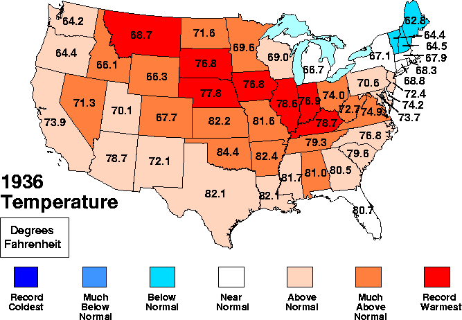
- 1936 North American heat wave
- 1997 Red River Flood1997 Red River Flood in the United StatesThe Red River Flood of 1997 in the United States was a major flood that occurred in April 1997, along the Red River of the North in North Dakota and Minnesota...