

South Branch Kishwaukee River
Encyclopedia
The South Branch Kishwaukee River is a 63.6 miles (102.4 km) tributary of the Kishwaukee River
in northern Illinois
. The South Branch is the main branch of the Kishwaukee River, joining it 10.6 miles (17.1 km) above its confluence
with the Rock River. The South Branch flows through DeKalb County
; in 2007 flooding along the tributary inundated areas of DeKalb County and Sycamore, Illinois
.
A separate South Branch Kishwaukee River flows through Kane County
and McHenry County
, joining the main stem of the Kishwaukee east of Marengo
.
of the Kishwaukee River
, originates on the Cropsey Moraine, near Shabbona, Illinois
. The stream flows in a northeast direction until it comes to Genoa
, where it makes a westerly turn and begins flowing west-northwest.
Of all tributaries of the Kishwaukee, the South Branch is the largest in terms of the area drained. The South Branch joins the main branch Kishwaukee River
about 10.6 miles (17.1 km) above the river's mouth at the Rock River. The South Branch flows through DeKalb County, Illinois
, draining 441 square miles (1,142 km²) of land area.
. The river wanders over moraine
s throughout its course. The substrate is rock strewn with sand and gravel; north of Sycamore
the river has been mined for gravel
. The average width of the South Branch is 55 feet (16.8 m). It has the lowest natural flow rate of any stream in the Kishwaukee River watershed. The stream, however, also receives the largest discharge of any of the streams in the watershed due to treated wastewater from the city of DeKalb
.
A 1996 Illinois Environmental Protection Agency
assessment of 62 miles (99.8 km) of the South Branch revealed that 30 miles (48.3 km) were "fair" condition and 32 miles (51.5 km) were characterized as "good". The assessment looked at overall resource quality and determined the factors responsible for lower quality conditions were "nutrients and organic enrichment (low dissolved oxygen) from agriculture and municipal point source pollution."
is 10 feet (3 m). Dating back to 1926 the South Branch has risen above flood stage nine times. The record flood occurred on July 2, 1983, when the river reached 15.8 feet (4.8 m). Flash flooding, which predominantly occurs in mid to late summer, can occur throughout the county in low lying areas on the flood plain. Flooding resulting in a federal disaster declaration occurred in 1973, 1974, 1993, 1996 and 2007.
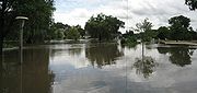 After 4.85 inches (12.3 cm) of rain fell on August 23 and 24, 2007, at DeKalb
, the South Branch Kishwaukee River rose to its highest level since 1983 and its second highest level in recorded history. Numerous roads and bridges were closed, and the cities of DeKalb and Sycamore
declared local emergencies. Federal disaster aid was made available when President George W. Bush declared DeKalb
, Grundy, Kane
, LaSalle, Lake
, and Will
counties, in northern Illinois, "major disaster" areas. The federal funding made individual assistance available to flood victims in Lake, Will and Grundy counties, and individual and public assistance available to those in DeKalb, Kane and LaSalle counties. In DeKalb and Sycamore, about 600 residents were displaced from their homes, and the DeKalb campus of Northern Illinois University
was closed because of the flood.
Kishwaukee River
The Kishwaukee River, sometimes locally known as simply "The Kish", is a river in the U.S. state of Illinois. "The Kish" is famous for its high number of bridges that cross within its 100-year floodplain.-Location:...
in northern Illinois
Northern Illinois
Northern Illinois is a region generally covering the northern third of the U.S. state of Illinois.-Economics:Northern Illinois is dominated by the metropolitan areas of Chicago, Rockford, and the Quad Cities, which contain a majority of Illinois' population and economic activity, including...
. The South Branch is the main branch of the Kishwaukee River, joining it 10.6 miles (17.1 km) above its confluence
Confluence
Confluence, in geography, describes the meeting of two or more bodies of water.Confluence may also refer to:* Confluence , a property of term rewriting systems...
with the Rock River. The South Branch flows through DeKalb County
DeKalb County, Illinois
DeKalb County is a county located in the U.S. state of Illinois. According to the 2010 census, it has a population of 105,160, which is an increase of 18.2% from 88,969 in 2000. Its county seat is Sycamore. DeKalb County is part of the Chicago metropolitan statistical area.-History:DeKalb County...
; in 2007 flooding along the tributary inundated areas of DeKalb County and Sycamore, Illinois
Sycamore, Illinois
Sycamore is a city in DeKalb County, Illinois, United States. It has a commercial district based and centered on Illinois Route 64. The population was 17,519 at the 2010 census, up from 12,020 at the 2000 census.-Early settlement:...
.
A separate South Branch Kishwaukee River flows through Kane County
Kane County, Illinois
Kane County is a county located in the U.S. state of Illinois. According to the 2010 census, it has a population of 515,269, which is an increase of 27.5% from 404,119 in 2000. Its county seat is Geneva, and its largest city is Aurora.- Geography :...
and McHenry County
McHenry County, Illinois
McHenry County is a county located in the U.S. state of Illinois. According to the 2010 census, it has a population of 308,760, which is an increase of 18.7% from 260,077 in 2000. Its county seat is Woodstock. This county is part of the Chicago metropolitan area. It is the sixth largest county, in...
, joining the main stem of the Kishwaukee east of Marengo
Marengo, Illinois
Marengo is a city in McHenry County, Illinois, United States. The population was 6,355 at the 2000 census.- Geography :Marengo is located at .According to the United States Census Bureau, the city has a total area of , all of it land.-Major Streets:...
.
Course
The South Branch Kishwaukee River, a major tributaryTributary
A tributary or affluent is a stream or river that flows into a main stem river or a lake. A tributary does not flow directly into a sea or ocean...
of the Kishwaukee River
Kishwaukee River
The Kishwaukee River, sometimes locally known as simply "The Kish", is a river in the U.S. state of Illinois. "The Kish" is famous for its high number of bridges that cross within its 100-year floodplain.-Location:...
, originates on the Cropsey Moraine, near Shabbona, Illinois
Shabbona, Illinois
Shabbona is a village in DeKalb County, Illinois, United States. The population was 925 at the 2010 census, down from 929 at the 2000 census.The village takes its name from the Potawatomi chief and peacemaker Shabbona. Chief Shabbona traveled through the Fox Valley warning the white people about...
. The stream flows in a northeast direction until it comes to Genoa
Genoa, Illinois
Genoa is a city in the north-east corner of DeKalb County, Illinois in the United States. It is located on the historic Galena-Chicago stagecoach route. At the 2010 census the city had a population of 5,193, up from 4,169 at the 2000 census.-History:...
, where it makes a westerly turn and begins flowing west-northwest.
Of all tributaries of the Kishwaukee, the South Branch is the largest in terms of the area drained. The South Branch joins the main branch Kishwaukee River
Kishwaukee River
The Kishwaukee River, sometimes locally known as simply "The Kish", is a river in the U.S. state of Illinois. "The Kish" is famous for its high number of bridges that cross within its 100-year floodplain.-Location:...
about 10.6 miles (17.1 km) above the river's mouth at the Rock River. The South Branch flows through DeKalb County, Illinois
DeKalb County, Illinois
DeKalb County is a county located in the U.S. state of Illinois. According to the 2010 census, it has a population of 105,160, which is an increase of 18.2% from 88,969 in 2000. Its county seat is Sycamore. DeKalb County is part of the Chicago metropolitan statistical area.-History:DeKalb County...
, draining 441 square miles (1,142 km²) of land area.
Description
Part of the South Branch's river bed is the plain of an ancient lakeAncient Lake
An ancient lake is a lake that carried water uninterruptedly for more than one million years. The vast majority of lakes, including very large ones such as the Great Lakes, are of much more recent origin...
. The river wanders over moraine
Moraine
A moraine is any glacially formed accumulation of unconsolidated glacial debris which can occur in currently glaciated and formerly glaciated regions, such as those areas acted upon by a past glacial maximum. This debris may have been plucked off a valley floor as a glacier advanced or it may have...
s throughout its course. The substrate is rock strewn with sand and gravel; north of Sycamore
Sycamore, Illinois
Sycamore is a city in DeKalb County, Illinois, United States. It has a commercial district based and centered on Illinois Route 64. The population was 17,519 at the 2010 census, up from 12,020 at the 2000 census.-Early settlement:...
the river has been mined for gravel
Gravel pit
Gravel pit is the term for an open cast working for extraction of gravel. Gravel pits often lie in river valleys where the water table is high, so they may fill naturally with water to form ponds or lakes. Old, abandoned gravel pits are normally used either as nature reserves, or as amenity areas...
. The average width of the South Branch is 55 feet (16.8 m). It has the lowest natural flow rate of any stream in the Kishwaukee River watershed. The stream, however, also receives the largest discharge of any of the streams in the watershed due to treated wastewater from the city of DeKalb
DeKalb, Illinois
DeKalb is a city in DeKalb County, Illinois, United States. The population was 43,862 at the 2010 census, up from 39,018 at the 2000 census. The city is named after decorated German war hero Johann De Kalb, who died during the American Revolutionary War....
.
A 1996 Illinois Environmental Protection Agency
Illinois Environmental Protection Agency
The Illinois Environmental Protection Agency of the state of Illinois is the primary body concerned with the protection of the environment for the state...
assessment of 62 miles (99.8 km) of the South Branch revealed that 30 miles (48.3 km) were "fair" condition and 32 miles (51.5 km) were characterized as "good". The assessment looked at overall resource quality and determined the factors responsible for lower quality conditions were "nutrients and organic enrichment (low dissolved oxygen) from agriculture and municipal point source pollution."
Flooding
Where the South Branch flows through DeKalb County flood stageFlood stage
Flood stage is the level at which the surface of a river, creek, or other body of water has risen to a sufficient level to cause damage or affects use of man-made structures...
is 10 feet (3 m). Dating back to 1926 the South Branch has risen above flood stage nine times. The record flood occurred on July 2, 1983, when the river reached 15.8 feet (4.8 m). Flash flooding, which predominantly occurs in mid to late summer, can occur throughout the county in low lying areas on the flood plain. Flooding resulting in a federal disaster declaration occurred in 1973, 1974, 1993, 1996 and 2007.
DeKalb, Illinois
DeKalb is a city in DeKalb County, Illinois, United States. The population was 43,862 at the 2010 census, up from 39,018 at the 2000 census. The city is named after decorated German war hero Johann De Kalb, who died during the American Revolutionary War....
, the South Branch Kishwaukee River rose to its highest level since 1983 and its second highest level in recorded history. Numerous roads and bridges were closed, and the cities of DeKalb and Sycamore
Sycamore, Illinois
Sycamore is a city in DeKalb County, Illinois, United States. It has a commercial district based and centered on Illinois Route 64. The population was 17,519 at the 2010 census, up from 12,020 at the 2000 census.-Early settlement:...
declared local emergencies. Federal disaster aid was made available when President George W. Bush declared DeKalb
DeKalb County, Illinois
DeKalb County is a county located in the U.S. state of Illinois. According to the 2010 census, it has a population of 105,160, which is an increase of 18.2% from 88,969 in 2000. Its county seat is Sycamore. DeKalb County is part of the Chicago metropolitan statistical area.-History:DeKalb County...
, Grundy, Kane
Kane County, Illinois
Kane County is a county located in the U.S. state of Illinois. According to the 2010 census, it has a population of 515,269, which is an increase of 27.5% from 404,119 in 2000. Its county seat is Geneva, and its largest city is Aurora.- Geography :...
, LaSalle, Lake
Lake County, Illinois
Lake County is a county in the northeastern corner of the state of Illinois, on the shore of Lake Michigan. According to the 2010 census, it has a population of 703,462, which is an increase of 9.2% from 644,356 in 2000. Its county seat is Waukegan. The county is part of the Chicago metropolitan area...
, and Will
Will County, Illinois
As of the census of 2000, there were 502,266 people, 167,542 households, and 131,017 families residing in the county. The population density was 600 people per square mile . There were 175,524 housing units at an average density of 210 per square mile...
counties, in northern Illinois, "major disaster" areas. The federal funding made individual assistance available to flood victims in Lake, Will and Grundy counties, and individual and public assistance available to those in DeKalb, Kane and LaSalle counties. In DeKalb and Sycamore, about 600 residents were displaced from their homes, and the DeKalb campus of Northern Illinois University
Northern Illinois University
Northern Illinois University is a state university and research institution located in DeKalb, Illinois, with satellite centers in Hoffman Estates, Naperville, Rockford, and Oregon. It was originally founded as Northern Illinois State Normal School on May 22, 1895 by Illinois Governor John P...
was closed because of the flood.