

Vernon County, Wisconsin
Encyclopedia
Vernon County is a county
in the U.S. state
of Wisconsin
. As of 2009, the population estimate was 29,324. Its county seat
is Viroqua
.
, the county has a total area of 816 square miles (2,113.4 km²), of which 795 square miles (2,059 km²) is land and 22 square miles (57 km²) (2.64%) is water.
As of the census
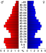
of 2000, there were 28,056 people, 10,825 households, and 7,501 families residing in the county. The population density
was 35 people per square mile (14/km²). There were 12,416 housing units at an average density of 16 per square mile (6/km²). The racial makeup of the county was 98.81% White
, 0.06% Black
or African American
, 0.15% Native American
, 0.21% Asian
, 0.01% Pacific Islander
, 0.27% from other races
, and 0.48% from two or more races. 0.66% of the population were Hispanic
or Latino
of any race. 38.3% were of Norwegian, 26.9% German, 6.4% Irish
and 6.1% English
ancestry. 90.9% spoke English
, 3.5% German
, 1.8% Norwegian
, 1.2% Pennsylvania Dutch
and 1.0% Spanish
as their first language.
There were 10,825 households out of which 31.50% had children under the age of 18 living with them, 58.70% were married couples
living together, 6.80% had a female householder with no husband present, and 30.70% were non-families. 26.70% of all households were made up of individuals and 13.70% had someone living alone who was 65 years of age or older. The average household size was 2.55 and the average family size was 3.11.
In the county, the population was spread out with 27.40% under the age of 18, 6.80% from 18 to 24, 25.30% from 25 to 44, 23.50% from 45 to 64, and 17.00% who were 65 years of age or older. The median age was 39 years. For every 100 females there were 97.70 males. For every 100 females age 18 and over, there were 95.60 males.
County (United States)
In the United States, a county is a geographic subdivision of a state , usually assigned some governmental authority. The term "county" is used in 48 of the 50 states; Louisiana is divided into parishes and Alaska into boroughs. Parishes and boroughs are called "county-equivalents" by the U.S...
in the U.S. state
U.S. state
A U.S. state is any one of the 50 federated states of the United States of America that share sovereignty with the federal government. Because of this shared sovereignty, an American is a citizen both of the federal entity and of his or her state of domicile. Four states use the official title of...
of Wisconsin
Wisconsin
Wisconsin is a U.S. state located in the north-central United States and is part of the Midwest. It is bordered by Minnesota to the west, Iowa to the southwest, Illinois to the south, Lake Michigan to the east, Michigan to the northeast, and Lake Superior to the north. Wisconsin's capital is...
. As of 2009, the population estimate was 29,324. Its county seat
County seat
A county seat is an administrative center, or seat of government, for a county or civil parish. The term is primarily used in the United States....
is Viroqua
Viroqua, Wisconsin
Viroqua is the county seat of Vernon County, Wisconsin, United States. The population was 5,079 at the 2010 census. The city is located within the Town of Viroqua.-History:...
.
History
Vernon County was renamed from Bad Axe County in 1862. Bad Axe County had been formed 11 years before, from portions of Richland and Crawford counties.Geography
According to the U.S. Census BureauUnited States Census Bureau
The United States Census Bureau is the government agency that is responsible for the United States Census. It also gathers other national demographic and economic data...
, the county has a total area of 816 square miles (2,113.4 km²), of which 795 square miles (2,059 km²) is land and 22 square miles (57 km²) (2.64%) is water.
Major highways
 U.S. Highway 14
 U.S. Highway 61


Adjacent counties
- La Crosse County - north western
- Monroe CountyMonroe County, WisconsinMonroe County is a county in the U.S. state of Wisconsin. As of 2000, the population was 40,899. Its county seat is Sparta.-Geography:According to the U.S...
- north - Juneau CountyJuneau County, WisconsinJuneau County is a county located in the U.S. state of Wisconsin. As of the 2000 census, the population was 24,316. Its county seat is Mauston. It should not, however, be confused with the city of Juneau, Wisconsin, to which it has no connection.-Geography:...
- northeast - Sauk CountySauk County, WisconsinSauk County is a county in the U.S. state of Wisconsin. As of 2000, the population was 55,225. Its county seat and largest city is Baraboo. Sauk County is included in the Baraboo Micropolitan Statistical Area and in the Madison Combined Statistical Area....
- east - Richland County - southeast
- Crawford County - south
- Allamakee County, IowaAllamakee County, Iowa-2010 census:The 2010 census recorded a population of 14,330 in the county, with a population density of . There were 7,617 housing units, of which 5,845 were occupied.-2000 census:...
- southwest - Houston County, MinnesotaHouston County, MinnesotaAs of the census of 2000, there were 19,718 people, 7,633 households, and 5,411 families residing in the county. The population density was 35 people per square mile . There were 8,168 housing units at an average density of 15 per square mile...
- west
Demographics
As of the census
Census
A census is the procedure of systematically acquiring and recording information about the members of a given population. It is a regularly occurring and official count of a particular population. The term is used mostly in connection with national population and housing censuses; other common...
of 2000, there were 28,056 people, 10,825 households, and 7,501 families residing in the county. The population density
Population density
Population density is a measurement of population per unit area or unit volume. It is frequently applied to living organisms, and particularly to humans...
was 35 people per square mile (14/km²). There were 12,416 housing units at an average density of 16 per square mile (6/km²). The racial makeup of the county was 98.81% White
Race (United States Census)
Race and ethnicity in the United States Census, as defined by the Federal Office of Management and Budget and the United States Census Bureau, are self-identification data items in which residents choose the race or races with which they most closely identify, and indicate whether or not they are...
, 0.06% Black
Race (United States Census)
Race and ethnicity in the United States Census, as defined by the Federal Office of Management and Budget and the United States Census Bureau, are self-identification data items in which residents choose the race or races with which they most closely identify, and indicate whether or not they are...
or African American
Race (United States Census)
Race and ethnicity in the United States Census, as defined by the Federal Office of Management and Budget and the United States Census Bureau, are self-identification data items in which residents choose the race or races with which they most closely identify, and indicate whether or not they are...
, 0.15% Native American
Race (United States Census)
Race and ethnicity in the United States Census, as defined by the Federal Office of Management and Budget and the United States Census Bureau, are self-identification data items in which residents choose the race or races with which they most closely identify, and indicate whether or not they are...
, 0.21% Asian
Race (United States Census)
Race and ethnicity in the United States Census, as defined by the Federal Office of Management and Budget and the United States Census Bureau, are self-identification data items in which residents choose the race or races with which they most closely identify, and indicate whether or not they are...
, 0.01% Pacific Islander
Race (United States Census)
Race and ethnicity in the United States Census, as defined by the Federal Office of Management and Budget and the United States Census Bureau, are self-identification data items in which residents choose the race or races with which they most closely identify, and indicate whether or not they are...
, 0.27% from other races
Race (United States Census)
Race and ethnicity in the United States Census, as defined by the Federal Office of Management and Budget and the United States Census Bureau, are self-identification data items in which residents choose the race or races with which they most closely identify, and indicate whether or not they are...
, and 0.48% from two or more races. 0.66% of the population were Hispanic
Race (United States Census)
Race and ethnicity in the United States Census, as defined by the Federal Office of Management and Budget and the United States Census Bureau, are self-identification data items in which residents choose the race or races with which they most closely identify, and indicate whether or not they are...
or Latino
Race (United States Census)
Race and ethnicity in the United States Census, as defined by the Federal Office of Management and Budget and the United States Census Bureau, are self-identification data items in which residents choose the race or races with which they most closely identify, and indicate whether or not they are...
of any race. 38.3% were of Norwegian, 26.9% German, 6.4% Irish
Irish people
The Irish people are an ethnic group who originate in Ireland, an island in northwestern Europe. Ireland has been populated for around 9,000 years , with the Irish people's earliest ancestors recorded having legends of being descended from groups such as the Nemedians, Fomorians, Fir Bolg, Tuatha...
and 6.1% English
English people
The English are a nation and ethnic group native to England, who speak English. The English identity is of early mediaeval origin, when they were known in Old English as the Anglecynn. England is now a country of the United Kingdom, and the majority of English people in England are British Citizens...
ancestry. 90.9% spoke English
English language
English is a West Germanic language that arose in the Anglo-Saxon kingdoms of England and spread into what was to become south-east Scotland under the influence of the Anglian medieval kingdom of Northumbria...
, 3.5% German
German language
German is a West Germanic language, related to and classified alongside English and Dutch. With an estimated 90 – 98 million native speakers, German is one of the world's major languages and is the most widely-spoken first language in the European Union....
, 1.8% Norwegian
Norwegian language
Norwegian is a North Germanic language spoken primarily in Norway, where it is the official language. Together with Swedish and Danish, Norwegian forms a continuum of more or less mutually intelligible local and regional variants .These Scandinavian languages together with the Faroese language...
, 1.2% Pennsylvania Dutch
Pennsylvania German language
The Pennsylvania German language is a variety of West Central German possibly spoken by more than 250,000 people in North America...
and 1.0% Spanish
Spanish language
Spanish , also known as Castilian , is a Romance language in the Ibero-Romance group that evolved from several languages and dialects in central-northern Iberia around the 9th century and gradually spread with the expansion of the Kingdom of Castile into central and southern Iberia during the...
as their first language.
There were 10,825 households out of which 31.50% had children under the age of 18 living with them, 58.70% were married couples
Marriage
Marriage is a social union or legal contract between people that creates kinship. It is an institution in which interpersonal relationships, usually intimate and sexual, are acknowledged in a variety of ways, depending on the culture or subculture in which it is found...
living together, 6.80% had a female householder with no husband present, and 30.70% were non-families. 26.70% of all households were made up of individuals and 13.70% had someone living alone who was 65 years of age or older. The average household size was 2.55 and the average family size was 3.11.
In the county, the population was spread out with 27.40% under the age of 18, 6.80% from 18 to 24, 25.30% from 25 to 44, 23.50% from 45 to 64, and 17.00% who were 65 years of age or older. The median age was 39 years. For every 100 females there were 97.70 males. For every 100 females age 18 and over, there were 95.60 males.
Cities, villages, and towns
- BergenBergen, Vernon County, WisconsinBergen is a town in Vernon County, Wisconsin, United States. The population was 1,317 at the 2000 census. The unincorporated community of Pleasant Valley is located in the town.-Geography:...
- ChaseburgChaseburg, WisconsinChaseburg is a village in Vernon County, Wisconsin, United States. The population was 306 at the 2000 census.-Geography:Chaseburg is located at ....
- ChristianaChristiana, Vernon County, WisconsinChristiana is a town in Vernon County, Wisconsin, United States. The population was 871 at the 2000 census. The unincorporated community of Newry is located within the town.-Geography:...
- ClintonClinton, Vernon County, WisconsinClinton is a town in Vernon County in the U.S. state of Wisconsin. The population was 1,354 at the 2000 census. The unincorporated community of Bloomington is located partially within the town.-Geography:...
- CoonCoon, WisconsinCoon is a town in Vernon County, Wisconsin, United States. The population was 683 at the 2000 census.-Geography:According to the United States Census Bureau, the town has a total area of 34.8 square miles , all of it land.-Demographics:...
- Coon ValleyCoon Valley, WisconsinCoon Valley is a village in Vernon County, Wisconsin, United States. The population was 714 at the 2000 census.-Geography:Coon Valley is located at ....
- De SotoDe Soto, WisconsinDe Soto is a village straddling Vernon and Crawford Counties in Wisconsin. The population was 366 at the 2000 census.-Geography:De Soto is located at ....
- ForestForest, Vernon County, WisconsinForest is a town in Vernon County, Wisconsin, United States. The population was 583 at the 2000 census. The unincorporated communities of Dilly and Valley are located in the town.-Geography:...
- FranklinFranklin, Vernon County, WisconsinFranklin is a town in Vernon County, Wisconsin, United States. The population was 923 at the 2000 census. The unincorporated communities of Fargo and Liberty Pole are located in the town.-Geography:...
- Genoa (town)Genoa (town), WisconsinGenoa is a town in Vernon County, Wisconsin, United States. The population was 705 at the 2000 census. The Village of Genoa is located within the town. Romance, Wisconsin is located in the town of Genoa...
- GenoaGenoa, WisconsinGenoa is a village in Vernon County, Wisconsin, United States. The population was 263 at the 2000 census. The village is within the Town of Genoa. There is also a village named Genoa City, Wisconsin.-Economy:...
- GreenwoodGreenwood, Vernon County, WisconsinGreenwood is a town in Vernon County, Wisconsin, United States. The population was 770 at the 2000 census.-Geography:According to the United States Census Bureau, the town has a total area of 35.8 square miles , all of it land....
- HamburgHamburg, Vernon County, WisconsinHamburg is a town in Vernon County, Wisconsin, United States. The population was 848 at the 2000 census.-Geography:According to the United States Census Bureau, the town has a total area of 35.8 square miles , of which, 35.8 square miles of it is land and 0.03% is...
- HarmonyHarmony, Vernon County, WisconsinHarmony is a town in Vernon County, Wisconsin, United States. The population was 739 at the 2000 census. The unincorporated community of Newton is located in the town.-Geography:...
- Hillsboro (town)Hillsboro (town), WisconsinHillsboro is a town in Vernon County, Wisconsin, United States. The population was 766 at the 2000 census. The City of Hillsboro is located within the town.-Geography:...
- HillsboroHillsboro, WisconsinHillsboro is a city in Vernon County, Wisconsin, United States. The population was 1,302 at the 2000 census. The city is located within the Town of Hillsboro...
- JeffersonJefferson, Vernon County, WisconsinJefferson is a town in Vernon County, Wisconsin, United States. The population was 974 at the 2000 census. The unincorporated communities of Bud and Esofea are located with the town.-Geography:...
- KickapooKickapoo, WisconsinKickapoo is a town in Vernon County, Wisconsin, United States. The population was 566 at the 2000 census. The unincorporated community of Kickapoo Center is located in the town.-Geography:...
- La FargeLa Farge, WisconsinLa Farge is a village along the Kickapoo River in Vernon County, Wisconsin, United States. The population was 775 at the 2000 census. The residential community of Dreamtime Village is located near LaFarge.-Transportation:...
- LibertyLiberty, Vernon County, WisconsinLiberty is a town in Vernon County, Wisconsin, United States. The population was 167 at the 2000 census. The unicorporated community of Ross is located in the town.-Geography:...
- OntarioOntario, WisconsinOntario is a village in Vernon County, Wisconsin, United States. The population was 476 at the 2000 census.-Attractions:* Wildcat Mountain State Park is located near Ontario.The Kickapoo River is used for kayaking and canoeing.-Geography:...
- ReadstownReadstown, WisconsinReadstown is a village in Vernon County, Wisconsin, United States. The population was 395 at the 2000 census.-Geography:Readstown is located at ....
- StarkStark, WisconsinStark is a town in Vernon County, Wisconsin, United States. The population was 349 at the 2000 census. The unincorporated community of Tunnelville is located partially in the town.-Geography:...
- SterlingSterling, Vernon County, WisconsinSterling is a town in Vernon County, Wisconsin, United States. The population was 713 at the 2000 census. The unincorporated communities of Purdy, Retreat, and West Prairie are located in the town.-Geography:...
- StoddardStoddard, WisconsinStoddard is a village in Vernon County, Wisconsin, United States. The population was 799 at the 2006 census.-Geography:Stoddard is located at ....
- UnionUnion, Vernon County, WisconsinUnion is a town in Vernon County, Wisconsin, United States. The population was 531 at the 2000 census.-Geography:According to the United States Census Bureau, the town has a total area of 35.8 square miles , all of it land....
- ViolaViola, WisconsinViola is a village in Richland and Vernon Counties in the U.S. state of Wisconsin, United States. The population was 667 at the 2000 census.-Geography:Viola is located at ....
- Viroqua (town)Viroqua (town), WisconsinViroqua is a town in Vernon County, Wisconsin, United States. The population was 1,560 at the 2000 census. The City of Viroqua is located within the town.-Geography:...
- ViroquaViroqua, WisconsinViroqua is the county seat of Vernon County, Wisconsin, United States. The population was 5,079 at the 2010 census. The city is located within the Town of Viroqua.-History:...
- WebsterWebster, Vernon County, WisconsinWebster is a town in Vernon County, Wisconsin, United States. The population was 676 at the 2000 census. The unincorporated community of Bloomingdale is located partially within the town.-Geography:...
- WestbyWestby, WisconsinWestby is a city in Vernon County, Wisconsin, United States. The population was 2,045 at the 2000 census.-History:Westby was named after general store owner and Civil War Union soldier Ole T. Westby of Biri, Norway, where many of the city's Norwegian-American settlers originated...
- WheatlandWheatland, Vernon County, WisconsinWheatland is a town in Vernon County, Wisconsin, United States. The population was 533 at the 2000 census. The unincorporated communities of Red Mound, and Victory are located in Wheatland.-Geography:...
- WhitestownWhitestown, WisconsinWhitestown is a town in Vernon County, Wisconsin, United States. The population was 509 at the 2000 census. The unincorporated community of Rockton is located in the town.-Geography:...
Unincorporated communities
- BloomingdaleBloomingdale, WisconsinBloomingdale is an unincorporated community in Vernon County, Wisconsin. It is located on the border of the towns of Clinton and Webster.-Notes:...
- BudBud, WisconsinBud is an unincorporated community located in the town of Jefferson, Vernon County, Wisconsin, United States....
- DillyDilly, WisconsinDilly is an unincorporated community located in the town of Forest, Vernon County, Wisconsin, United States....
- EsofeaEsofea, WisconsinEsofea, Wisconsin is an unincorporated community in the town of Jefferson in Vernon County, Wisconsin, United States located along County Road B.-History:...
- FargoFargo, WisconsinFargo is an unincorporated community located in the town of Franklin, Vernon County, Wisconsin, United States....
- Kickapoo CenterKickapoo Center, WisconsinKickapoo Center is an unincorporated community located in the town of Kickapoo, Vernon County, Wisconsin, United States. Kickapoo Center is located on Wisconsin Highway 131 near the Kickapoo River, south-southwest of Viola.-History:...
- Liberty PoleLiberty Pole, WisconsinLiberty Pole, Wisconsin is an unincorporated community in Vernon County, Wisconsin in the town of Franklin.-External links:*...
- NewryNewry, WisconsinNewry is an unincorporated community in Vernon County, Wisconsin, United States, within the town of Christiana.-References:...
- NewtonNewton, Vernon County, WisconsinNewton is an unincorporated community located in the town of Harmony, Vernon County, Wisconsin, United States. Newton is located on the North Fork Bad Axe River east-northeast of Viroqua....
- Pleasant ValleyPleasant Valley, Vernon County, WisconsinPleasant Valley is an unincorporated community located in the town of Bergen, Vernon County, Wisconsin, United States....
- PurdyPurdy, WisconsinPurdy is an unincorporated community located in the town of Sterling, Vernon County, Wisconsin, United States....
- Red MoundRed Mound, WisconsinRed Mound, Wisconsin is an unincorporated community in Vernon County, Wisconsin located in the town of Wheatland.-External links:*...
- RetreatRetreat, WisconsinRetreat, Wisconsin is an unincorporated community in Vernon County, Wisconsin in the town of Sterling.-External links:*...
- RocktonRockton, WisconsinRockton is an unincorporated community in Vernon County, Wisconsin, United States in the town of Whitestown. It is located on the Kickapoo River and is served by Wisconsin Highway 131. Rockton is south of Ontario and north of La Farge; these are the closest villages to the community....
- RomanceRomance, WisconsinRomance, Wisconsin is an unincorporated community in the town of Genoa in Vernon County, Wisconsin, United States.-Religion:RoundRiver Institute LCC is a Buddhist retreat and education center located in Romance not too far away from the village of Genoa, Wisconsin.-Sources:**...
- RossRoss, Vernon County, WisconsinRoss is an unincorporated community located in the town of Liberty, Vernon County, Wisconsin, United States....
- TunnelvilleTunnelville, WisconsinTunnelville is an unincorporated community in the counties of Richland and Vernon in the U.S. state of Wisconsin. The portion in Richland County is located in the town of Forest, and the portion in Vernon County is located in the town of Stark....
(partial) - ValleyValley, WisconsinValley is an unincorporated community in the town of Forest, Vernon County, Wisconsin, United States....
- VictoryVictory, WisconsinVictory, Wisconsin is a small unincorporated community in the Town of Wheatland in Vernon County, Wisconsin. It is located 4.5 miles north of De Soto and 6.2 miles south of Genoa on the Mississippi River along the Great River Road . The Battle of Bad Axe, the final battle of the Black Hawk War of...
- West PrairieWest Prairie, WisconsinWest Prairie is an unincorporated community located in the town of Sterling, Vernon County, Wisconsin, United States....
See also
- National Register of Historic Places listings in Vernon County, Wisconsin
- Upper Mississippi River National Wildlife and Fish RefugeUpper Mississippi River National Wildlife and Fish RefugeThe Upper Mississippi River National Wildlife and Fish Refuge is a . 261 river mile long National Wildlife Refuge located in and along the Upper Mississippi River. It runs from Wabasha, Minnesota in the north to Rock Island, Illinois in the south....