

Whitewater State Park
Encyclopedia
Minnesota
Minnesota is a U.S. state located in the Midwestern United States. The twelfth largest state of the U.S., it is the twenty-first most populous, with 5.3 million residents. Minnesota was carved out of the eastern half of the Minnesota Territory and admitted to the Union as the thirty-second state...
state park in Winona County in the southeastern blufflands area of the state. The 2700 acres (11 km²) park features scenic overlooks and excellent trout
Trout
Trout is the name for a number of species of freshwater and saltwater fish belonging to the Salmoninae subfamily of the family Salmonidae. Salmon belong to the same family as trout. Most salmon species spend almost all their lives in salt water...
fishing in the spring fed Whitewater River and Trout Run Creek. It has about 300,000 visitors annually, and is located 7 miles (11 km) north of St. Charles
St. Charles, Minnesota
As of the census of 2000, there were 3,295 people, 1,238 households, and 870 families residing in the city. The population density was 1,005.3 people per square mile . There were 1,276 housing units at an average density of 389.3 per square mile...
on Minnesota State Highway 74
Minnesota State Highway 74
Minnesota State Highway 74 is a highway in southeast Minnesota, which runs from its intersection with U.S. Highway 52 and State Highway 30 in Chatfield and continues north to its northern terminus at its intersection with U.S...
which runs through the park.
Historic structures
Many of the buildings and other structures in the park are listed on the National Register of Historic PlacesNational Register of Historic Places
The National Register of Historic Places is the United States government's official list of districts, sites, buildings, structures, and objects deemed worthy of preservation...
as a historic district.
Landforms
The bedrock here is lower PaleozoicPaleozoic
The Paleozoic era is the earliest of three geologic eras of the Phanerozoic eon, spanning from roughly...
sedimentary rocks, with limestone
Limestone
Limestone is a sedimentary rock composed largely of the minerals calcite and aragonite, which are different crystal forms of calcium carbonate . Many limestones are composed from skeletal fragments of marine organisms such as coral or foraminifera....
and dolomite
Dolomite
Dolomite is a carbonate mineral composed of calcium magnesium carbonate CaMg2. The term is also used to describe the sedimentary carbonate rock dolostone....
especially prevalent near the surface. It is highly dissected, and the Whitewater River has cut deep valleys into the bedrock. It is an area of karst
KARST
Kilometer-square Area Radio Synthesis Telescope is a Chinese telescope project to which FAST is a forerunner. KARST is a set of large spherical reflectors on karst landforms, which are bowlshaped limestone sinkholes named after the Kras region in Slovenia and Northern Italy. It will consist of...
topography.
Lifeforms
The park is located where the Rochester Plateau Subsection and the Blufflands Subsection meet, both of which are part of the Paleozoic Plateau section of the Eastern Broadleaf Forest Province.2007 flood
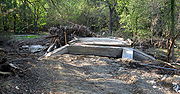
The August 18 and 19, 2007 Midwest flooding2007 Midwest flooding
The 2007 Midwest flooding was a major flooding event that occurred in the Midwestern United States in the third week of August 2007. While Hurricane Dean was affecting the Yucatán Peninsula and the Gulf of Mexico, and Tropical Storm Erin was affecting Oklahoma and Texas, a persistent storm system...
caused extensive damage to the park. The park is in the Driftless Area, where soils are thin and less able to retain water; they lie atop porous rock into and through which surface waters can rapidly drain into the water table. The steep hills and bluffs and deep coulee
Coulee
Coulee is applied rather loosely to different landforms, all of which refer to a kind of valley or drainage zone.The word coulee comes from the Canadian French coulée, from French word couler meaning "to flow"....
s give steep gradients to the drainage and makes streams highly erosive. As the rains far exceeded the absorption rate of the soils, flash floods rapidly overflowed the river and spread across the valley floors.
About 500 campers were staying in the park at the time. Three bridges were destroyed, and campgrounds, bathhouses, a group dining hall, and water and sewer systems suffered extensive damage. Damage was in excess of four million dollars, and the park was closed to the public on August 20, 2007, and remained closed the balance of the year. On March 1, 2008 it partially reopened, but many of its amenities still had unrepaired damage.