
1930 Dominican Republic Hurricane
Encyclopedia
The 1930 Dominican Republic Hurricane, also known as Hurricane San Zenon, is the fifth deadliest Atlantic hurricane on record. The second of two known tropical cyclones in the 1930 Atlantic hurricane season
, the hurricane was first observed on August 29 to the east of the Lesser Antilles
. The cyclone was a small but intense Category 4 hurricane
, killing as many as 8,000 people when it crossed the Dominican Republic
.
islands, although there were indications it may have formed closer to the African coast a few days earlier. Moving westward, the system slowly intensified, with its track and path based mainly on continuity. It is estimated to have become a hurricane on August 31 about 385 miles (620 km) east of Guadeloupe
. Operationally, the hurricane was first observed on September 1, while the storm was passing through the Lesser Antilles
as an intensifying hurricane. Based on north winds in Dominica
and south winds in Barbados
, the evidence of the circulation prompted an observer to report, "[there are] evidences of an approaching hurricane." Cautionary advice was immediately sent out from Barbados to Saint Lucia
, and based on additional ship and island reports, the National Weather Bureau issued storm warnings for the southern coasts of Puerto Rico
and Hispaniola
.
After passing over or near Dominica, the hurricane entered the Caribbean Sea
with winds of 100 mi/h, the equivalence of a Category 2 hurricane on the Saffir-Simpson hurricane scale
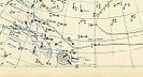
. On September 2, the hurricane passed about 60 mi (95 km) southwest of Puerto Rico
as it intensified into a major hurricane. Due to the storm's small size, winds on the island were below hurricane force. Continuing slowly west-northwestward, the hurricane continued to intensify as it approached the Dominican Republic
. A steamship just offshore recorded winds of 150 mph (241.4 km/h), and also provided data to estimate the radius of maximum wind
s at 8 mi (13 km). At 1800 UTC
on September 3, it made landfall
near Santo Domingo
, Dominican Republic with a minimum central pressure of 933 mbar (27.6 inHg). As it was still intensifying up until landfall, the peak winds were estimated at 155 mi/h, although it is possible it attained Category 5 status. The worst of the hurricane occurred in a 2 miles (3.2 km) diameter of its landfall location.
The mountainous terrain of Hispaniola
rapidly weakened the hurricane, and by about 12 hours after moving ashore the winds decreased to tropical storm status. It quickly emerged into the Windward Passage
and moved westward to the south of the Cuban coastline. On September 6 the storm crossed western Cuba before recurving northeastward into the Gulf of Mexico
with winds of 40 mph (64.4 km/h). It strengthened slightly, moving ashore near Tampa, Florida
with 45 mph (75 km/h) winds. While crossing the state, it weakened to tropical depression status, although it re-intensified after moving into the western Atlantic Ocean. By September 12, it again attained hurricane status to the southeast of the Carolinas. After brushing the Outer Banks
of North Carolina with winds of 70 mph (110 km/h), the hurricane turned eastward and reached a secondary peak intensity of 100 mph (160 km/h) to the north of Bermuda
. It gradually weakened, deteriorating to tropical storm status on September 16 and dissipating the next day to the west of the Azores
. The remnants merged with a system that later affected the Azores and Ireland.
, with winds of hurricane force winds reported across the Lesser Antilles
. The hurricane wrecked crops across the island and destroyed every ship at the harbor, killing 2 people. Rough seas also occurred along the coast of Saint Kitts
, and a ship recorded a pressure of 969 mbar
near the island.
In southern Puerto Rico
, the winds reached less than hurricane force, which caused minor to moderate damage to plantations. Rainfall across the island was dispersed unusually; the maximum amount on the island was over 6 inches (152.4 mm) in Cabo Rojo
on the southwestern portion of the island, while the minimum amount was under 1 inches (25.4 mm) at a location in the center of the southern coastline. Rainfall reached over 2 inches (50.8 mm) inches along the northern coast, with totals varying from 1 inches (25.4 mm) to 4 inches (101.6 mm) in the mountainous interior. The precipitation was considered generally beneficial, due to previously dry conditions across the island.
On September 3 the storm was a Category 4 when it struck the Dominican Republic
capital city of Santo Domingo
, leaving a path of destruction around 20 miles (32.2 km) wide. Wind gusts in the city were estimated from 150 miles per hour (241.4 km/h) to 200 miles per hour (321.9 km/h); a gust of 180 miles per hour (289.7 km/h) was recorded by a Pan-American Airways
anemometer
before it was blown away. Similarly, another observation in the capital city recorded winds of 100 miles per hour (160.9 km/h) before the roof it was on was damaged. It was estimated as among the strongest hurricanes on record to strike the country. Three entire districts of the city were almost completely destroyed, and an Associated Press
report indicated there was [scarcely] a wreck of a wall left standing. Overall, the hurricane leveled about half of the entire city. Due to its small nature, villagers 75 miles (120 km) from the landfall location had no knowledge of the storm. Heavy rainfall from the storm flooded the Ozama River
and increased its flow to 15 mi/h, which prevented boats from traversing the river. The passage of the hurricane caused severe damage estimated at $15–$50 million (1930 USD), with the storm considered a major disaster in the area. The Red Cross
estimated 2,000 people perished in the city, with an additional 8,000 injured. However, the death toll may never be known, and historians estimate the hurricane left between 2,000 to 8,000 killed.
Minor effects were reported away from the coast; the mountainous terrain of Hispaniola
greatly weakened the hurricane, which prevented significant amounts of further deaths or damage. Effects in the mountainous areas included downed trees and crop damage. In Haiti
, the hurricane produced locally gusty winds and heavy amounts of rainfall, though exact damage details for the nation are unknown. Despite crossing the island of Cuba
, no damage or deaths were reported there. Upon moving through the U.S. state
of Florida
, the storm remained severely weakened; during its passage a pressure of 1006 mbar
was reported in Tampa
, the lowest pressure in the state. The threat of the hurricane prompted the National Weather Bureau to issue storm warnings
from Southport, North Carolina
through the Virginia Capes
. The strongest winds remained offshore, with minor damage reported along the Outer Banks
. On Cape Lookout
, the hurricane downed 12 small-frame buildings and damaged the city's Coast Guard
headquarters. Power outages were also reported, leaving some areas on the Outer Banks isolated from communication to the outside world.
 Relief work in the Dominican Republic
began immediately after the hurricane, personally organized by President Rafael Leónidas Trujillo
. The president deployed the entire nation's military within 24 hours of the passage of the hurricane. By the day after its passage, lack of food had become a problem, and large numbers of robberies had occurred. The winds downed all communications inside of the city, leaving damage details unknown until communications were partially restored a day after its landfall. The city plant of the newspaper La Opinión
was destroyed, with three staff members killed; the remaining workers transmitted a damage story to offices in New York City, and included a plea for disaster assistance. The Red Cross office in Washington, D.C.
sent $15,000 (1930 USD) in aid a day after the hurricane struck.
1930 Atlantic hurricane season
The 1930 Atlantic hurricane season was one of the least active hurricane seasons on record, with only three documented tropical cyclones. In the North Atlantic Ocean, hurricanes generally form between the months of June and November, with most occurring in August and September. The first system of...
, the hurricane was first observed on August 29 to the east of the Lesser Antilles
Lesser Antilles
The Lesser Antilles are a long, partly volcanic island arc in the Western Hemisphere. Most of its islands form the eastern boundary of the Caribbean Sea with the Atlantic Ocean, with the remainder located in the southern Caribbean just north of South America...
. The cyclone was a small but intense Category 4 hurricane
Saffir-Simpson Hurricane Scale
The Saffir–Simpson Hurricane Scale , or the Saffir–Simpson Hurricane Wind Scale , classifies hurricanes — Western Hemisphere tropical cyclones that exceed the intensities of tropical depressions and tropical storms — into five categories distinguished by the intensities of their sustained winds...
, killing as many as 8,000 people when it crossed the Dominican Republic
Dominican Republic
The Dominican Republic is a nation on the island of La Hispaniola, part of the Greater Antilles archipelago in the Caribbean region. The western third of the island is occupied by the nation of Haiti, making Hispaniola one of two Caribbean islands that are shared by two countries...
.
Meteorological history
The system is estimated to have formed on August 29 about halfway between the Lesser Antilles and the Cape VerdeCape Verde
The Republic of Cape Verde is an island country, spanning an archipelago of 10 islands located in the central Atlantic Ocean, 570 kilometres off the coast of Western Africa...
islands, although there were indications it may have formed closer to the African coast a few days earlier. Moving westward, the system slowly intensified, with its track and path based mainly on continuity. It is estimated to have become a hurricane on August 31 about 385 miles (620 km) east of Guadeloupe
Guadeloupe
Guadeloupe is an archipelago located in the Leeward Islands, in the Lesser Antilles, with a land area of 1,628 square kilometres and a population of 400,000. It is the first overseas region of France, consisting of a single overseas department. As with the other overseas departments, Guadeloupe...
. Operationally, the hurricane was first observed on September 1, while the storm was passing through the Lesser Antilles
Lesser Antilles
The Lesser Antilles are a long, partly volcanic island arc in the Western Hemisphere. Most of its islands form the eastern boundary of the Caribbean Sea with the Atlantic Ocean, with the remainder located in the southern Caribbean just north of South America...
as an intensifying hurricane. Based on north winds in Dominica
Dominica
Dominica , officially the Commonwealth of Dominica, is an island nation in the Lesser Antilles region of the Caribbean Sea, south-southeast of Guadeloupe and northwest of Martinique. Its size is and the highest point in the country is Morne Diablotins, which has an elevation of . The Commonwealth...
and south winds in Barbados
Barbados
Barbados is an island country in the Lesser Antilles. It is in length and as much as in width, amounting to . It is situated in the western area of the North Atlantic and 100 kilometres east of the Windward Islands and the Caribbean Sea; therein, it is about east of the islands of Saint...
, the evidence of the circulation prompted an observer to report, "[there are] evidences of an approaching hurricane." Cautionary advice was immediately sent out from Barbados to Saint Lucia
Saint Lucia
Saint Lucia is an island country in the eastern Caribbean Sea on the boundary with the Atlantic Ocean. Part of the Lesser Antilles, it is located north/northeast of the island of Saint Vincent, northwest of Barbados and south of Martinique. It covers a land area of 620 km2 and has an...
, and based on additional ship and island reports, the National Weather Bureau issued storm warnings for the southern coasts of Puerto Rico
Puerto Rico
Puerto Rico , officially the Commonwealth of Puerto Rico , is an unincorporated territory of the United States, located in the northeastern Caribbean, east of the Dominican Republic and west of both the United States Virgin Islands and the British Virgin Islands.Puerto Rico comprises an...
and Hispaniola
Hispaniola
Hispaniola is a major island in the Caribbean, containing the two sovereign states of the Dominican Republic and Haiti. The island is located between the islands of Cuba to the west and Puerto Rico to the east, within the hurricane belt...
.
After passing over or near Dominica, the hurricane entered the Caribbean Sea
Caribbean Sea
The Caribbean Sea is a sea of the Atlantic Ocean located in the tropics of the Western hemisphere. It is bounded by Mexico and Central America to the west and southwest, to the north by the Greater Antilles, and to the east by the Lesser Antilles....
with winds of 100 mi/h, the equivalence of a Category 2 hurricane on the Saffir-Simpson hurricane scale
Saffir-Simpson Hurricane Scale
The Saffir–Simpson Hurricane Scale , or the Saffir–Simpson Hurricane Wind Scale , classifies hurricanes — Western Hemisphere tropical cyclones that exceed the intensities of tropical depressions and tropical storms — into five categories distinguished by the intensities of their sustained winds...
. On September 2, the hurricane passed about 60 mi (95 km) southwest of Puerto Rico
Puerto Rico
Puerto Rico , officially the Commonwealth of Puerto Rico , is an unincorporated territory of the United States, located in the northeastern Caribbean, east of the Dominican Republic and west of both the United States Virgin Islands and the British Virgin Islands.Puerto Rico comprises an...
as it intensified into a major hurricane. Due to the storm's small size, winds on the island were below hurricane force. Continuing slowly west-northwestward, the hurricane continued to intensify as it approached the Dominican Republic
Dominican Republic
The Dominican Republic is a nation on the island of La Hispaniola, part of the Greater Antilles archipelago in the Caribbean region. The western third of the island is occupied by the nation of Haiti, making Hispaniola one of two Caribbean islands that are shared by two countries...
. A steamship just offshore recorded winds of 150 mph (241.4 km/h), and also provided data to estimate the radius of maximum wind
Radius of maximum wind
The radius of maximum wind is the distance between the center of a cyclone and its band of strongest winds. It is a parameter in atmospheric dynamics and tropical cyclone forecasting. The highest rainfall rates occur near the RMW of tropical cyclones. The extent of a cyclone's storm surge and...
s at 8 mi (13 km). At 1800 UTC
Coordinated Universal Time
Coordinated Universal Time is the primary time standard by which the world regulates clocks and time. It is one of several closely related successors to Greenwich Mean Time. Computer servers, online services and other entities that rely on having a universally accepted time use UTC for that purpose...
on September 3, it made landfall
Landfall (meteorology)
Landfall is the event of a tropical cyclone or a waterspout coming onto land after being over water. When a waterspout makes landfall it is reclassified as a tornado, which can then cause damage inland...
near Santo Domingo
Santo Domingo
Santo Domingo, known officially as Santo Domingo de Guzmán, is the capital and largest city in the Dominican Republic. Its metropolitan population was 2,084,852 in 2003, and estimated at 3,294,385 in 2010. The city is located on the Caribbean Sea, at the mouth of the Ozama River...
, Dominican Republic with a minimum central pressure of 933 mbar (27.6 inHg). As it was still intensifying up until landfall, the peak winds were estimated at 155 mi/h, although it is possible it attained Category 5 status. The worst of the hurricane occurred in a 2 miles (3.2 km) diameter of its landfall location.
The mountainous terrain of Hispaniola
Hispaniola
Hispaniola is a major island in the Caribbean, containing the two sovereign states of the Dominican Republic and Haiti. The island is located between the islands of Cuba to the west and Puerto Rico to the east, within the hurricane belt...
rapidly weakened the hurricane, and by about 12 hours after moving ashore the winds decreased to tropical storm status. It quickly emerged into the Windward Passage
Windward Passage
The Windward Passage is a strait in the Caribbean Sea, between the islands of Cuba and Hispaniola. The strait specifically lies between the easternmost region of Cuba and the northwest of Haiti.80km wide, the Windward Passage has a threshold depth of 1,700m...
and moved westward to the south of the Cuban coastline. On September 6 the storm crossed western Cuba before recurving northeastward into the Gulf of Mexico
Gulf of Mexico
The Gulf of Mexico is a partially landlocked ocean basin largely surrounded by the North American continent and the island of Cuba. It is bounded on the northeast, north and northwest by the Gulf Coast of the United States, on the southwest and south by Mexico, and on the southeast by Cuba. In...
with winds of 40 mph (64.4 km/h). It strengthened slightly, moving ashore near Tampa, Florida
Tampa, Florida
Tampa is a city in the U.S. state of Florida. It serves as the county seat for Hillsborough County. Tampa is located on the west coast of Florida. The population of Tampa in 2010 was 335,709....
with 45 mph (75 km/h) winds. While crossing the state, it weakened to tropical depression status, although it re-intensified after moving into the western Atlantic Ocean. By September 12, it again attained hurricane status to the southeast of the Carolinas. After brushing the Outer Banks
Outer Banks
The Outer Banks is a 200-mile long string of narrow barrier islands off the coast of North Carolina, beginning in the southeastern corner of Virginia Beach on the east coast of the United States....
of North Carolina with winds of 70 mph (110 km/h), the hurricane turned eastward and reached a secondary peak intensity of 100 mph (160 km/h) to the north of Bermuda
Bermuda
Bermuda is a British overseas territory in the North Atlantic Ocean. Located off the east coast of the United States, its nearest landmass is Cape Hatteras, North Carolina, about to the west-northwest. It is about south of Halifax, Nova Scotia, Canada, and northeast of Miami, Florida...
. It gradually weakened, deteriorating to tropical storm status on September 16 and dissipating the next day to the west of the Azores
Azores
The Archipelago of the Azores is composed of nine volcanic islands situated in the middle of the North Atlantic Ocean, and is located about west from Lisbon and about east from the east coast of North America. The islands, and their economic exclusion zone, form the Autonomous Region of the...
. The remnants merged with a system that later affected the Azores and Ireland.
Impact
Winds of 80 to 100 mi/h were reported on DominicaDominica
Dominica , officially the Commonwealth of Dominica, is an island nation in the Lesser Antilles region of the Caribbean Sea, south-southeast of Guadeloupe and northwest of Martinique. Its size is and the highest point in the country is Morne Diablotins, which has an elevation of . The Commonwealth...
, with winds of hurricane force winds reported across the Lesser Antilles
Lesser Antilles
The Lesser Antilles are a long, partly volcanic island arc in the Western Hemisphere. Most of its islands form the eastern boundary of the Caribbean Sea with the Atlantic Ocean, with the remainder located in the southern Caribbean just north of South America...
. The hurricane wrecked crops across the island and destroyed every ship at the harbor, killing 2 people. Rough seas also occurred along the coast of Saint Kitts
Saint Kitts
Saint Kitts Saint Kitts Saint Kitts (also known more formally as Saint Christopher Island (Saint-Christophe in French) is an island in the West Indies. The west side of the island borders the Caribbean Sea, and the eastern coast faces the Atlantic Ocean...
, and a ship recorded a pressure of 969 mbar
Bar (unit)
The bar is a unit of pressure equal to 100 kilopascals, and roughly equal to the atmospheric pressure on Earth at sea level. Other units derived from the bar are the megabar , kilobar , decibar , centibar , and millibar...
near the island.
In southern Puerto Rico
Puerto Rico
Puerto Rico , officially the Commonwealth of Puerto Rico , is an unincorporated territory of the United States, located in the northeastern Caribbean, east of the Dominican Republic and west of both the United States Virgin Islands and the British Virgin Islands.Puerto Rico comprises an...
, the winds reached less than hurricane force, which caused minor to moderate damage to plantations. Rainfall across the island was dispersed unusually; the maximum amount on the island was over 6 inches (152.4 mm) in Cabo Rojo
Cabo Rojo, Puerto Rico
Cabo Rojo is a municipality situated on the southwest coast of Puerto Rico and forms part of the San Germán–Cabo Rojo metropolitan area as well as the larger Mayagüez–San Germán–Cabo Rojo Combined Statistical Area....
on the southwestern portion of the island, while the minimum amount was under 1 inches (25.4 mm) at a location in the center of the southern coastline. Rainfall reached over 2 inches (50.8 mm) inches along the northern coast, with totals varying from 1 inches (25.4 mm) to 4 inches (101.6 mm) in the mountainous interior. The precipitation was considered generally beneficial, due to previously dry conditions across the island.
On September 3 the storm was a Category 4 when it struck the Dominican Republic
Dominican Republic
The Dominican Republic is a nation on the island of La Hispaniola, part of the Greater Antilles archipelago in the Caribbean region. The western third of the island is occupied by the nation of Haiti, making Hispaniola one of two Caribbean islands that are shared by two countries...
capital city of Santo Domingo
Santo Domingo
Santo Domingo, known officially as Santo Domingo de Guzmán, is the capital and largest city in the Dominican Republic. Its metropolitan population was 2,084,852 in 2003, and estimated at 3,294,385 in 2010. The city is located on the Caribbean Sea, at the mouth of the Ozama River...
, leaving a path of destruction around 20 miles (32.2 km) wide. Wind gusts in the city were estimated from 150 miles per hour (241.4 km/h) to 200 miles per hour (321.9 km/h); a gust of 180 miles per hour (289.7 km/h) was recorded by a Pan-American Airways
Pan American World Airways
Pan American World Airways, commonly known as Pan Am, was the principal and largest international air carrier in the United States from 1927 until its collapse on December 4, 1991...
anemometer
Anemometer
An anemometer is a device for measuring wind speed, and is a common weather station instrument. The term is derived from the Greek word anemos, meaning wind, and is used to describe any airspeed measurement instrument used in meteorology or aerodynamics...
before it was blown away. Similarly, another observation in the capital city recorded winds of 100 miles per hour (160.9 km/h) before the roof it was on was damaged. It was estimated as among the strongest hurricanes on record to strike the country. Three entire districts of the city were almost completely destroyed, and an Associated Press
Associated Press
The Associated Press is an American news agency. The AP is a cooperative owned by its contributing newspapers, radio and television stations in the United States, which both contribute stories to the AP and use material written by its staff journalists...
report indicated there was [scarcely] a wreck of a wall left standing. Overall, the hurricane leveled about half of the entire city. Due to its small nature, villagers 75 miles (120 km) from the landfall location had no knowledge of the storm. Heavy rainfall from the storm flooded the Ozama River
Ozama River
The Ozama River in the Dominican Republic can trace its source to the Loma Siete Cabezas in the Sierra de Yamasá close to Villa Altagracia....
and increased its flow to 15 mi/h, which prevented boats from traversing the river. The passage of the hurricane caused severe damage estimated at $15–$50 million (1930 USD), with the storm considered a major disaster in the area. The Red Cross
International Red Cross and Red Crescent Movement
The International Red Cross and Red Crescent Movement is an international humanitarian movement with approximately 97 million volunteers, members and staff worldwide which was founded to protect human life and health, to ensure respect for all human beings, and to prevent and alleviate human...
estimated 2,000 people perished in the city, with an additional 8,000 injured. However, the death toll may never be known, and historians estimate the hurricane left between 2,000 to 8,000 killed.
Minor effects were reported away from the coast; the mountainous terrain of Hispaniola
Hispaniola
Hispaniola is a major island in the Caribbean, containing the two sovereign states of the Dominican Republic and Haiti. The island is located between the islands of Cuba to the west and Puerto Rico to the east, within the hurricane belt...
greatly weakened the hurricane, which prevented significant amounts of further deaths or damage. Effects in the mountainous areas included downed trees and crop damage. In Haiti
Haiti
Haiti , officially the Republic of Haiti , is a Caribbean country. It occupies the western, smaller portion of the island of Hispaniola, in the Greater Antillean archipelago, which it shares with the Dominican Republic. Ayiti was the indigenous Taíno or Amerindian name for the island...
, the hurricane produced locally gusty winds and heavy amounts of rainfall, though exact damage details for the nation are unknown. Despite crossing the island of Cuba
Cuba
The Republic of Cuba is an island nation in the Caribbean. The nation of Cuba consists of the main island of Cuba, the Isla de la Juventud, and several archipelagos. Havana is the largest city in Cuba and the country's capital. Santiago de Cuba is the second largest city...
, no damage or deaths were reported there. Upon moving through the U.S. state
U.S. state
A U.S. state is any one of the 50 federated states of the United States of America that share sovereignty with the federal government. Because of this shared sovereignty, an American is a citizen both of the federal entity and of his or her state of domicile. Four states use the official title of...
of Florida
Florida
Florida is a state in the southeastern United States, located on the nation's Atlantic and Gulf coasts. It is bordered to the west by the Gulf of Mexico, to the north by Alabama and Georgia and to the east by the Atlantic Ocean. With a population of 18,801,310 as measured by the 2010 census, it...
, the storm remained severely weakened; during its passage a pressure of 1006 mbar
Bar (unit)
The bar is a unit of pressure equal to 100 kilopascals, and roughly equal to the atmospheric pressure on Earth at sea level. Other units derived from the bar are the megabar , kilobar , decibar , centibar , and millibar...
was reported in Tampa
Tampa, Florida
Tampa is a city in the U.S. state of Florida. It serves as the county seat for Hillsborough County. Tampa is located on the west coast of Florida. The population of Tampa in 2010 was 335,709....
, the lowest pressure in the state. The threat of the hurricane prompted the National Weather Bureau to issue storm warnings
Tropical cyclone warnings and watches
Warnings and watches are two levels of alert issued by national weather forecasting bodies to coastal areas threatened by the imminent approach of a tropical cyclone of tropical storm or hurricane intensity. They are notices to the local population and civil authorities to make appropriate...
from Southport, North Carolina
Southport, North Carolina
Southport is a city in Brunswick County, North Carolina, near the mouth of the Cape Fear River. It is part of the Wilmington Metropolitan Statistical Area...
through the Virginia Capes
Virginia Capes
The Virginia Capes are the two capes, Cape Charles to the north and Cape Henry to the south, that define the entrance to Chesapeake Bay on the eastern coast of North America....
. The strongest winds remained offshore, with minor damage reported along the Outer Banks
Outer Banks
The Outer Banks is a 200-mile long string of narrow barrier islands off the coast of North Carolina, beginning in the southeastern corner of Virginia Beach on the east coast of the United States....
. On Cape Lookout
Cape Lookout
Cape Lookout can refer to:*Cape Lookout , in the United States*Cape Lookout , in the United States*Cape Lookout...
, the hurricane downed 12 small-frame buildings and damaged the city's Coast Guard
United States Coast Guard
The United States Coast Guard is a branch of the United States Armed Forces and one of the seven U.S. uniformed services. The Coast Guard is a maritime, military, multi-mission service unique among the military branches for having a maritime law enforcement mission and a federal regulatory agency...
headquarters. Power outages were also reported, leaving some areas on the Outer Banks isolated from communication to the outside world.
Aftermath
Dominican Republic
The Dominican Republic is a nation on the island of La Hispaniola, part of the Greater Antilles archipelago in the Caribbean region. The western third of the island is occupied by the nation of Haiti, making Hispaniola one of two Caribbean islands that are shared by two countries...
began immediately after the hurricane, personally organized by President Rafael Leónidas Trujillo
Rafael Leónidas Trujillo
Rafael Leónidas Trujillo Molina , nicknamed El Jefe , ruled the Dominican Republic from 1930 until his assassination in 1961. He officially served as president from 1930 to 1938 and again from 1942 to 1952, otherwise ruling as an unelected military strongman...
. The president deployed the entire nation's military within 24 hours of the passage of the hurricane. By the day after its passage, lack of food had become a problem, and large numbers of robberies had occurred. The winds downed all communications inside of the city, leaving damage details unknown until communications were partially restored a day after its landfall. The city plant of the newspaper La Opinión
La Opinión
La Opinión is a Spanish-language daily newspaper published in Los Angeles, California, USA and distributed throughout the six counties of Southern California. It is the largest Spanish-language newspaper in the United States and second-most read newspaper in Los Angeles . It is published by...
was destroyed, with three staff members killed; the remaining workers transmitted a damage story to offices in New York City, and included a plea for disaster assistance. The Red Cross office in Washington, D.C.
Washington, D.C.
Washington, D.C., formally the District of Columbia and commonly referred to as Washington, "the District", or simply D.C., is the capital of the United States. On July 16, 1790, the United States Congress approved the creation of a permanent national capital as permitted by the U.S. Constitution....
sent $15,000 (1930 USD) in aid a day after the hurricane struck.
See also
- List of Atlantic hurricanes
- List of deadliest Atlantic hurricanes