
Whitefield, Greater Manchester
Encyclopedia
Whitefield is a town within the Metropolitan Borough of Bury
, in Greater Manchester
, England. It lies on undulating ground in the Irwell Valley
, along the south bank of the River Irwell
, 3 miles (4.8 km) south-southeast of Bury
, and 4.9 miles (7.9 km) to the north-northwest of the city of Manchester
. Prestwich
and the M60 motorway
lie to the south.
Historically
a part of Lancashire
, Whitefield has been suggested as lying on the path of an ancient Roman road
leading from Mamucium (Manchester) in the south to Bremetennacum
(Ribchester
) in the north. Throughout the Middle Ages
, Whitefield was a division of the township of Pilkington
, itself a part of the parish of Prestwich-cum-Oldham
and hundred of Salford
. Pilkington and Whitefield have historic associations with the Earls of Derby
. Farming was the main industry of this rural area, with locals supplementing their incomes by hand-loom woollen weaving in the domestic system.
The urbanisation and development of Whitefield largely coincided with the Industrial Revolution
. The name Whitefield is thought to derive from the medieval bleachfield
s used by Flemish
settlers to whiten their woven fabrics, or else from the wheat
crop once cultivated in the district. The construction of a major roads routed through the village facilitated Whitefield's expansion into a mill town
during the mid-19th century. Whitefield was created a local government district in 1866, and was governed by a local board of health
until 1894, when the area of the local board became an urban district
.
In Remains, Historical and Literary, Connected with the Palatine Counties of Lancaster and Chester (1861), the will
of a John Rhodes describes leaving ownership of land in Whitefield Moore in Pilkington, to his son.
of Pilkington
. In the 15th century the Pilkington family who, during the Wars of the Roses
, supported the House of York
, owned much of the land around the parish. Thomas Pilkington was at this time lord
of many estates in Lancashire including the Manor of Bury. In 1485 Richard III
was killed in the Battle of Bosworth. The Duke of Richmond
, representing the House of Lancaster
, was crowned Henry VII
. Sir William Stanley
may have placed the crown upon his head. As a reward for the support of his family, on 27 October 1485 Henry made Thomas Stanley
the Earl of Derby
. Thomas Pilkington was attainted
, and in February 1489 Earl Thomas was given many confiscated estates including those of Pilkington, which included the township of Pilkington
, and Bury
. With their seat at Knowsley Hall
, the Earls of Derby were by and large absentee landlords who appointed agents to manage their interests in the area, unlike the Earls of Wilton
whose lands at Prestwich
bordered the area and who oversaw events on their estate and dispensed charity from Heaton Hall.
Over the centuries, hamlets grew at Besses o' th' Barn
, Lily Hill, Four Lane Ends (now the junction around Moss Lane and Pinfold Lane), Stand
and Park Gate (now the junction around Park Lane and Pinfold Lane) before being generalised into the area known as Whitefield. Besses o'th'Barn was for some time known as Stone Pale and a small street of that name still exists.
. Pilkington ceased to be a township in 1894 and at the same time part of the old boundary of Whitefield was absorbed by Radcliffe
. The realignment of the boundary with Radcliffe was due to the location of the Whitefield sewage works, which lying between Hillock and Parr Lane were in the wrong place to serve the Stand Lane area. Whitefield had gained a local board in 1866, but with the dissolution of Pilkington township Whitefield became an urban district
with two wards, in the administrative county
of Lancashire
.
A town hall was established in 1933 with the purchase of the house previously known as Underley, along with 3 acres (12,140.6 m²) of surrounding land. Before this the council chambers had been on Elms Street. On 1 April 1974 Whitefield became an unparished area
of the Metropolitan Borough of Bury
, a local government district of the metropolitan county
of Greater Manchester
.
, Whitefield lies on the west side of the conjunction of the M60
and M66
motorways, and south of the River Irwell
. The larger towns of Bury
and Middleton
lie to the north and east respectively. For purposes of the Office for National Statistics
, Whitefield forms part of the Greater Manchester Urban Area
, with Manchester city centre
itself 4.9 miles (7.9 km) south-southeast of Whitefield.
Localities within Whitefield include Besses o' th' Barn
, Chapel Field, Hillock, Lily Hill, Park Lane and Stand.
Whitefield has some substantial areas which are not built upon, consisting principally of the lands owned by Whitefield Golf Club, Stand Golf Club and Philips Park
.
The area has three medium-sized housing estates (Hillock Estate, Elms Estate and Victoria Estate) which originally consisted of only council-owned properties. The Elms estate was constructed in the 1920s and 1930s, whilst the Hillock estate was conceived in the 1950s as an overspill estate
for 8,000 people rehoused from the nearby ward of Bradford, and Beswick
, which were at the time undergoing housing clearances. All three estates now include privately-owned properties bought from council ownership under right-to-buy schemes, with the remainder managed by Six Town Housing, an arms-length management organisation (ALMO) set up by the Metropolitan Borough of Bury.
The area also encompasses the affluent community surrounding Ringley Road. In recent years the area has seen new construction work on infill
sites, and some residential development of brownfield sites more generally.
In 2001, a census was taken of the United Kingdom
, recording such details as people's age, ethnicity, and religion. According to the Office for National Statistics
, at the time of the census Whitefield had a population of 23,283. The 2001 population density was 13460 PD/sqmi, with a 100 to 91.3 female-to-male ratio. Of those over 16 years old, 28.8% were single (never married) 44.6% married, and 8.4% divorced. Whitefield's 9,849 households included 29.8% one-person, 36.8% married couples living together, 8.3% were co-habiting
couples, and 11.4% single parents with their children. Of those aged 16–74, 30.2% had no academic qualifications
.
As of the 2001 UK census, 74.3% of Whitefield's residents reported themselves as being Christian, 6.0% Jewish, 1.6% Muslim, 0.6% Hindu, 0.2% Buddhist, and 0.1% Sikh. The census recorded 10.3% as having no religion, 0.1% had an alternative religion and 6.9% did not state their religion.
for Whitefield in 1666 show that there were 135 hearths. Further, that the population numbered in 1714 a total of 740; that in 1789 it was 2455; and in 1793 that it was 2780. Some of the population statistics which he quotes subsequently in his book, and presumably based upon the Official Census returns since 1901, do on occasion differ very slightly from those quoted below.
In 1906 the following textile bleaching, dyeing and finishing businesses existed in Whitefield: John Brierley (at Spring Clough); W.E. Buckley & Co Ltd (Hollins Vale); R & A Chambers Ltd (Spring Waters); Thomas L Livesey Ltd (Hollins Vale); Mark Fletcher & Sons Ltd (Moss Lane Mills, having been founded in Little Lever in 1854); William Hampson (Besses); Kilner Croft Dyeing Co Ltd (Unsworth); Whitefield Velvet & Cord Dyeing Co Ltd (Crow Oak Works); and Philip Worrall (Hollins Vale).
At the same time there were five cotton manufacturers in the area: J G Clayton and Nelson Greenhalgh & Co (both at Albert Mills, on what was then Workhouse Lane); Lord, Frears & Bro. (Whitefield New Mill); Francis Mather (Whitefield Mill); and Worthington & Co (Victoria Mills, Unsworth). There were also two smallware manuacturers in the area, being Prestwich Smallware Co (on Hardmans Green, Besses) and the Victoria Smallware Co on Narrow Lane. There were also at least two firms in the building trade: John Jackson & Son, builder and joiners, on Livesey Street; and F.M. & H. Nuttall, builders and stonemasons, who were on Moss Lane and later had their stoneyard adjoining the west side of Whitefield railway station.
Whitefield's proximity to the M60 orbital motorway and city of Manchester has ensured that there are many small businesses and trading estates located locally. Whitefield has experienced several new commercial developments since the turn of the century, for example with the replacement of Elms shopping precinct by a new gym and several new outlets and with a new Morrisons
supermarket built in 2008 on land previously occupied by a public house, the bus station and a former retail premises which had seen several uses.
There used to be sweet factory on Stanley Road - Halls
, then arguably most famous for their "Mentho-Lyptus" product, sometimes spelled Menthol Lyptus - and there still is a fairly large flooring company in the Radcliffe New Road area; apart from these, most of the businesses are small.
According to the 2001 UK census, the industry of employment of residents of Whitefield aged 16–74 was 18.9% retail and wholesale, 13.7% manufacturing, 12.2% health and social work, 11.9% property and business services, 8.2% transport and communications, 7.6% education, 6.5% construction, 5.5% finance, 5.4 public administration, 4.3% hotels and restaurants, 0.7% energy and water supply, 0.5% agriculture, 0.1% mining, and 4.7% other. Compared with national figures, the town had a relatively high proportion of people working in finance, and low levels of people working in agriculture. The census recorded the economic activity of residents aged 16–74, 2.1% students were with jobs, 3.2% students without jobs, 5.4% looking after home or family, 7.2% permanently sick or disabled, and 3.0% economically inactive for other reasons.
 Public transport began some time in the early 19th century and in 1817 there were coach services being run through Whitefield between Manchester and Bury along Bury Old Road, which had been constructed in 1755. However, Wilson speculates that these were probably mainly for freight and states that the Coach & Horses public house at Kirkhams was the coaching inn.
Bury New Road –a turnpike road, taking an alternative route between Bury and Manchester - was constructed in 1827. Toll bars for this newly constructed road were built at Kersal Bar
, Besses o'th' Barn, Stand Lane and Blackford Bridge.
In the 1860s and 1870s transport between Whitefield and Manchester consisted of a four-horse bus running at hourly intervals, with local passenger stops at the Bay Horse Inn at Chapelfield and at the Church Inn in the centre of the town. The firm which operated this service was called Turner, after which Turner Street was named.
The Bury, Oldham and Rochdale Tramways Company operated a service of trams pulled by a steam engine from 1883. These ran until the end of the century between Bury and Kersal Bar, when they were replaced by electric trams leased by Salford Corporation between Bury and Manchester along both Bury Old Road and Bury New Road. The lease expired in 1926 and the trams between Whitefield and Manchester were then replaced by buses, also operated by Salford Corporation. In the same year, Bury Corporation provided buses to operate from Whitefield to Bury. A bus station, now demolished, was opened in 1931 just set back from the junction of Stanley Road and Bury New Road, behind the then Church Inn.
In the 1920s the evening trams from Whitefield and Manchester had a letterbox fitted to their fronts, enabling letters to be posted at the tram stops in time to reach the last post collection at Manchester post sorting office.
By 1905 electric trams were also running between Whitefield and Radcliffe along Radcliffe New Road.
On 18 July 1872 the Lancashire and Yorkshire Railway
(L&YR) gained an Act of Parliament to construct a railway between Manchester and Bury, via Whitefield and Prestwich
. This opened in 1879 with a new station, known as Whitefield railway station
. The L&YR line was electrified
in 1916 for which a power station was constructed near the Manchester Bolton & Bury Canal at nearby Clifton, with substations at Radcliffe
and at Victoria Station, Manchester
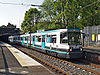
. Electrification reduced the journey times between Manchester and Bury from 32 minutes to 24. The line is now used by the Metrolink
, upon which services commenced on 6 April 1992. A station at nearby Besses o'th' Barn
also serves the area, having been opened on 1 February 1933.
All public transport is supervised by the Greater Manchester Passenger Transport Executive
.
Whilst preaching the nonconformist position, Stand Chapel was not at this time Unitarian. The transition to Unitarianism was gradual, being completed in 1789 when the Rev R Aubrey determined to follow the doctrine (it was in fact illegal to call oneself a Unitarian until 1813). This doctrinal decision caused a split, with some of the congregation leaving to form Stand Independent Chapel on Stand Lane.
Stand Unitarian Chapel was demolished and another built, capable of seating 400, in 1818.
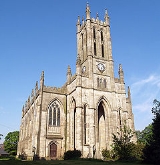
Stand All Saints CofE
Church, which was a so-called 'Waterloo Church', having been built to celebrate Napoleon's defeat at the Battle of Waterloo in 1815, is located just outside the town centre. The site was given by the Earl of Derby
and the first stone laid by the Earl of Wilton
on 3 August 1822. Consecrated on 8 September 1826 by Dr Blomfield
, Bishop of Chester, it was designed by Sir Charles Barry
in the Gothic style of the fourteenth century. The tower is 186 feet (56.7 m) in height. The cost of the building was £14,987. A clock was added to the tower in 1832 and then replaced in 1906. The church forms the centrepiece of the All Saints conservation area
, designated by the local council in March 2004.
Roman Catholics were of sufficient number by 1952 that they rented a room at the Liberal Club building, which was at that time on Morley Street; subsequently, in 1956, St Bernadette's Church was built on Manchester Road as their place of worship. The building cost £22,446 and the foundation stone was laid on 26 March 1955; although the stone bears the name of Bishop H V Marshall it was in fact laid by the Vicar General, Monsignor J Cunningham, due to the illness of the former.
A few years later, and next door to St Bernadette's, a meetinghouse of The Church of Jesus Christ of Latter-day Saints was erected.
Other places of worship in the area include the New Jerusalem Church on Charles Street (there is another on Stand Lane), Whitefield Methodist Chapel, Besses United Reform Church, two synagogues and a spiritualist church.
In August 2010 it was reported that a planning application had been submitted to the Metropolitan Borough of Bury
, on behalf of the Whitefield Hebrew Congregation, for the creation of a 4 miles (6.4 km) symbolic boundary, known as an eruv
, around 1 square mile of Whitefield. The construction of the eruv would allow the 700 Orthodox Jewish
families living in the area to carry out activities normally prohibited on the Hebrew shabbat
(sabbath), such as carrying keys, pushing prams and using wheelchairs. Similar eruvim have already been created in a number of cities such as New York, Antwerp and London. The Whitefield eruv would be the first to be constructed in the United Kingdom outside London.
and Radcliffe
) is The Advertiser, (one of the GMWN Greater Manchester Weekly News newspapers) a weekly freesheet based in Salford. The other local paper (not distributed freely, door to door) is the Prestwich and Whitefield Guide.
Sedgley Park RUFC play their home matches at their Park Lane
ground, and were in National Division One until the end of the 2008/09 season..
Besses o'th' Barn Band, and subsequently its associated Boys' Band, has existed in the area since at least 1818, at which time it had converted from a string band to a reed band. Its founders were John, James and Joseph Clegg - three brothers who were manufacturers of cotton products at Besses o'th' Barn - and for this reason it was for a time known as Clegg's Reed Band. Originally using a room called the mangle room, attached to the old barn at Besses which was pulled down in the 1880s, it has had its headquarters on Moss Lane since 1884. At the peak of its fame in the early 1900s this Band, by now using brass instruments, undertook numerous prestigious engagements, including world tours lasting well in excess of 12 months at a time.
Around 1883 a Thomas Thorp established an engineering business in Victoria Lane, complete with an astronomical observatory on its roof for his own use. He invented the penny-in-the-slot gas meter.
Metropolitan Borough of Bury
The Metropolitan Borough of Bury is a metropolitan borough of Greater Manchester, in North West England. Lying to the north of the City of Manchester, the borough is composed of six towns: Bury, Ramsbottom, Tottington, Radcliffe, Whitefield and Prestwich, and has a population of 181,900...
, in Greater Manchester
Greater Manchester
Greater Manchester is a metropolitan county in North West England, with a population of 2.6 million. It encompasses one of the largest metropolitan areas in the United Kingdom and comprises ten metropolitan boroughs: Bolton, Bury, Oldham, Rochdale, Stockport, Tameside, Trafford, Wigan, and the...
, England. It lies on undulating ground in the Irwell Valley
Irwell Valley
The Irwell Valley extends from the Forest of Rossendale in North West England, through to the cities of Salford and Manchester. The River Irwell runs through the valley, along with the River Croal.-Geology:...
, along the south bank of the River Irwell
River Irwell
The River Irwell is a long river which flows through the Irwell Valley in the counties of Lancashire and Greater Manchester in North West England. The river's source is at Irwell Springs on Deerplay Moor, approximately north of Bacup, in the parish of Cliviger, Lancashire...
, 3 miles (4.8 km) south-southeast of Bury
Bury
Bury is a town in Greater Manchester, England. It lies on the River Irwell, east of Bolton, west-southwest of Rochdale, and north-northwest of the city of Manchester...
, and 4.9 miles (7.9 km) to the north-northwest of the city of Manchester
Manchester
Manchester is a city and metropolitan borough in Greater Manchester, England. According to the Office for National Statistics, the 2010 mid-year population estimate for Manchester was 498,800. Manchester lies within one of the UK's largest metropolitan areas, the metropolitan county of Greater...
. Prestwich
Prestwich
Prestwich is a town within the Metropolitan Borough of Bury, in Greater Manchester, England. It lies close to the River Irwell, north of Manchester city centre, north of Salford and south of Bury....
and the M60 motorway
M60 motorway
The M60 motorway, or Manchester Orbital, is an orbital motorway circling Greater Manchester, a metropolitan county in North West England. It passes through all Greater Manchester's metropolitan boroughs except for Wigan and Bolton...
lie to the south.
Historically
Historic counties of England
The historic counties of England are subdivisions of England established for administration by the Normans and in most cases based on earlier Anglo-Saxon kingdoms and shires...
a part of Lancashire
Lancashire
Lancashire is a non-metropolitan county of historic origin in the North West of England. It takes its name from the city of Lancaster, and is sometimes known as the County of Lancaster. Although Lancaster is still considered to be the county town, Lancashire County Council is based in Preston...
, Whitefield has been suggested as lying on the path of an ancient Roman road
Roman road
The Roman roads were a vital part of the development of the Roman state, from about 500 BC through the expansion during the Roman Republic and the Roman Empire. Roman roads enabled the Romans to move armies and trade goods and to communicate. The Roman road system spanned more than 400,000 km...
leading from Mamucium (Manchester) in the south to Bremetennacum
Bremetennacum
Bremetennacum was a Roman fort which is now the village of Ribchester in Lancashire . The site is a Scheduled Ancient Monument. The first Roman activity on the site was the establishment of a timber fort believed to have been constructed during the campaigns of Petillius Cerialis around AD 72/3...
(Ribchester
Ribchester
Ribchester is a village and civil parish within the Ribble Valley district of Lancashire, England. It lies on the banks of the River Ribble, northwest of Blackburn and east of Preston.The village has a long history with evidence of Bronze Age beginnings...
) in the north. Throughout the Middle Ages
Middle Ages
The Middle Ages is a periodization of European history from the 5th century to the 15th century. The Middle Ages follows the fall of the Western Roman Empire in 476 and precedes the Early Modern Era. It is the middle period of a three-period division of Western history: Classic, Medieval and Modern...
, Whitefield was a division of the township of Pilkington
Pilkington (ancient township)
Pilkington was a township in the parish of Prestwich-cum-Oldham, hundred of Salford and county of Lancashire, in northern England.-Manor:The Pilkington family can be traced from about 1200. The senior line acquired the manor of Bury when Roger Pilkington who died in about 1347, married Alice Bury...
, itself a part of the parish of Prestwich-cum-Oldham
Prestwich-cum-Oldham
Prestwich-cum-Oldham was an ancient ecclesiastical parish of the hundred of Salford, within the historic county boundaries of Lancashire, England...
and hundred of Salford
Salford (hundred)
The hundred of Salford was an ancient division of the historic county of Lancashire, in Northern England. It was sometimes known as Salfordshire, the name alluding to its judicial centre being the township of Salford...
. Pilkington and Whitefield have historic associations with the Earls of Derby
Earl of Derby
Earl of Derby is a title in the Peerage of England. The title was first adopted by Robert de Ferrers, 1st Earl of Derby under a creation of 1139. It continued with the Ferrers family until the 6th Earl forfeited his property toward the end of the reign of Henry III and died in 1279...
. Farming was the main industry of this rural area, with locals supplementing their incomes by hand-loom woollen weaving in the domestic system.
The urbanisation and development of Whitefield largely coincided with the Industrial Revolution
Industrial Revolution
The Industrial Revolution was a period from the 18th to the 19th century where major changes in agriculture, manufacturing, mining, transportation, and technology had a profound effect on the social, economic and cultural conditions of the times...
. The name Whitefield is thought to derive from the medieval bleachfield
Bleachfield
A bleachfield or croft was an open area of land used for spreading cloth and fabrics on the ground to be bleached by the action of the sun and water...
s used by Flemish
Flemish people
The Flemings or Flemish are the Dutch-speaking inhabitants of Belgium, where they are mostly found in the northern region of Flanders. They are one of two principal cultural-linguistic groups in Belgium, the other being the French-speaking Walloons...
settlers to whiten their woven fabrics, or else from the wheat
Wheat
Wheat is a cereal grain, originally from the Levant region of the Near East, but now cultivated worldwide. In 2007 world production of wheat was 607 million tons, making it the third most-produced cereal after maize and rice...
crop once cultivated in the district. The construction of a major roads routed through the village facilitated Whitefield's expansion into a mill town
Mill town
A mill town, also known as factory town or mill village, is typically a settlement that developed around one or more mills or factories .- United Kingdom:...
during the mid-19th century. Whitefield was created a local government district in 1866, and was governed by a local board of health
Local board of health
Local Boards or Local Boards of Health were local authorities in urban areas of England and Wales from 1848 to 1894. They were formed in response to cholera epidemics and were given powers to control sewers, clean the streets, regulate slaughterhouses and ensure the proper supply of water to their...
until 1894, when the area of the local board became an urban district
Urban district
In the England, Wales and Ireland, an urban district was a type of local government district that covered an urbanised area. Urban districts had an elected Urban District Council , which shared local government responsibilities with a county council....
.
Toponymy
There are several theories for the origin of the place name, discussed in two local history publications. One, published in John Wilson's A History of Whitefield (1979), is that the name is derived from the Flemish weavers who used to lay out their fabrics to bleach in the sun (a process known as tentering). Although Wilson doubts this, believing it to be chronologically inaccurate, another theory relies on the fact that historically, Whitefield has been a farming community of open fields, and that the name is a corruption of "Wheat-fields". A third is that the name refers to a field of white flowers, evidenced by the existence of the area of Lily Hill Street.In Remains, Historical and Literary, Connected with the Palatine Counties of Lancaster and Chester (1861), the will
Will (law)
A will or testament is a legal declaration by which a person, the testator, names one or more persons to manage his/her estate and provides for the transfer of his/her property at death...
of a John Rhodes describes leaving ownership of land in Whitefield Moore in Pilkington, to his son.
Early history
In Elizabethan times Whitefield was mostly moorland and until the nineteenth century existed, along with the districts of Ringley, Unsworth and Outwood, as part of the ManorManorialism
Manorialism, an essential element of feudal society, was the organizing principle of rural economy that originated in the villa system of the Late Roman Empire, was widely practiced in medieval western and parts of central Europe, and was slowly replaced by the advent of a money-based market...
of Pilkington
Pilkington (ancient township)
Pilkington was a township in the parish of Prestwich-cum-Oldham, hundred of Salford and county of Lancashire, in northern England.-Manor:The Pilkington family can be traced from about 1200. The senior line acquired the manor of Bury when Roger Pilkington who died in about 1347, married Alice Bury...
. In the 15th century the Pilkington family who, during the Wars of the Roses
Wars of the Roses
The Wars of the Roses were a series of dynastic civil wars for the throne of England fought between supporters of two rival branches of the royal House of Plantagenet: the houses of Lancaster and York...
, supported the House of York
House of York
The House of York was a branch of the English royal House of Plantagenet, three members of which became English kings in the late 15th century. The House of York was descended in the paternal line from Edmund of Langley, 1st Duke of York, the fourth surviving son of Edward III, but also represented...
, owned much of the land around the parish. Thomas Pilkington was at this time lord
Lord of the Manor
The Lordship of a Manor is recognised today in England and Wales as a form of property and one of three elements of a manor that may exist separately or be combined and may be held in moieties...
of many estates in Lancashire including the Manor of Bury. In 1485 Richard III
Richard III of England
Richard III was King of England for two years, from 1483 until his death in 1485 during the Battle of Bosworth Field. He was the last king of the House of York and the last of the Plantagenet dynasty...
was killed in the Battle of Bosworth. The Duke of Richmond
Duke of Richmond
The title Duke of Richmond is named after Richmond and its surrounding district of Richmondshire, and has been created several times in the Peerage of England for members of the royal Tudor and Stuart families...
, representing the House of Lancaster
House of Lancaster
The House of Lancaster was a branch of the royal House of Plantagenet. It was one of the opposing factions involved in the Wars of the Roses, an intermittent civil war which affected England and Wales during the 15th century...
, was crowned Henry VII
Henry VII of England
Henry VII was King of England and Lord of Ireland from his seizing the crown on 22 August 1485 until his death on 21 April 1509, as the first monarch of the House of Tudor....
. Sir William Stanley
William Stanley (Battle of Bosworth)
Sir William Stanley was an English soldier and the younger brother of Thomas Stanley, 1st Earl of Derby. Stanley fought with his troops in several battles of the Wars of the Roses.-Private life:...
may have placed the crown upon his head. As a reward for the support of his family, on 27 October 1485 Henry made Thomas Stanley
Thomas Stanley, 1st Earl of Derby
Thomas Stanley, 1st Earl of Derby, KG was titular King of Mann, an English nobleman and stepfather to King Henry VII of England...
the Earl of Derby
Earl of Derby
Earl of Derby is a title in the Peerage of England. The title was first adopted by Robert de Ferrers, 1st Earl of Derby under a creation of 1139. It continued with the Ferrers family until the 6th Earl forfeited his property toward the end of the reign of Henry III and died in 1279...
. Thomas Pilkington was attainted
Attainder
In English criminal law, attainder or attinctura is the metaphorical 'stain' or 'corruption of blood' which arises from being condemned for a serious capital crime . It entails losing not only one's property and hereditary titles, but typically also the right to pass them on to one's heirs...
, and in February 1489 Earl Thomas was given many confiscated estates including those of Pilkington, which included the township of Pilkington
Pilkington (ancient township)
Pilkington was a township in the parish of Prestwich-cum-Oldham, hundred of Salford and county of Lancashire, in northern England.-Manor:The Pilkington family can be traced from about 1200. The senior line acquired the manor of Bury when Roger Pilkington who died in about 1347, married Alice Bury...
, and Bury
Bury
Bury is a town in Greater Manchester, England. It lies on the River Irwell, east of Bolton, west-southwest of Rochdale, and north-northwest of the city of Manchester...
. With their seat at Knowsley Hall
Knowsley Hall
Knowsley Hall is a stately home near Liverpool within the Metropolitan Borough of Knowsley, in Merseyside, England. It has been designated by English Heritage as a Grade II* listed building, and is the ancestral home of the Stanley family, the Earls of Derby. The hall is surrounded by of...
, the Earls of Derby were by and large absentee landlords who appointed agents to manage their interests in the area, unlike the Earls of Wilton
Earl of Wilton
Earl of Wilton, of Wilton Castle in the County of Hereford, is a title in the Peerage of the United Kingdom. It was created in 1801 for Thomas Egerton, 1st Baron Grey de Wilton, along with the subsidiary title of Viscount Grey de Wilton, also in the Peerage of the United Kingdom...
whose lands at Prestwich
Prestwich
Prestwich is a town within the Metropolitan Borough of Bury, in Greater Manchester, England. It lies close to the River Irwell, north of Manchester city centre, north of Salford and south of Bury....
bordered the area and who oversaw events on their estate and dispensed charity from Heaton Hall.
Over the centuries, hamlets grew at Besses o' th' Barn
Besses o' th' Barn
Besses o' th' Barn is an area of Whitefield within the Metropolitan Borough of Bury, in Greater Manchester, England. It lies between Radcliffe and Prestwich....
, Lily Hill, Four Lane Ends (now the junction around Moss Lane and Pinfold Lane), Stand
Stand, Greater Manchester
Stand is a village in Greater Manchester, England near Radcliffe. It is a residential area. There is no agreed origin of the name....
and Park Gate (now the junction around Park Lane and Pinfold Lane) before being generalised into the area known as Whitefield. Besses o'th'Barn was for some time known as Stone Pale and a small street of that name still exists.
Governance
Whitefield was in 1853 a part of the township of Pilkington, in the parish of Prestwich-cum-OldhamPrestwich-cum-Oldham
Prestwich-cum-Oldham was an ancient ecclesiastical parish of the hundred of Salford, within the historic county boundaries of Lancashire, England...
. Pilkington ceased to be a township in 1894 and at the same time part of the old boundary of Whitefield was absorbed by Radcliffe
Radcliffe, Greater Manchester
Radcliffe is a town within the Metropolitan Borough of Bury, in Greater Manchester, England. It lies on undulating ground in the Irwell Valley, along the course of the River Irwell, south-west of Bury and north-northwest of Manchester. Radcliffe is contiguous with the town of Whitefield to the...
. The realignment of the boundary with Radcliffe was due to the location of the Whitefield sewage works, which lying between Hillock and Parr Lane were in the wrong place to serve the Stand Lane area. Whitefield had gained a local board in 1866, but with the dissolution of Pilkington township Whitefield became an urban district
Urban district
In the England, Wales and Ireland, an urban district was a type of local government district that covered an urbanised area. Urban districts had an elected Urban District Council , which shared local government responsibilities with a county council....
with two wards, in the administrative county
Administrative counties of England
Administrative counties were a level of subnational division of England used for the purposes of local government from 1889 to 1974. They were created by the Local Government Act 1888 as the areas for which county councils were elected. Some large counties were divided into several administrative...
of Lancashire
Lancashire
Lancashire is a non-metropolitan county of historic origin in the North West of England. It takes its name from the city of Lancaster, and is sometimes known as the County of Lancaster. Although Lancaster is still considered to be the county town, Lancashire County Council is based in Preston...
.
A town hall was established in 1933 with the purchase of the house previously known as Underley, along with 3 acres (12,140.6 m²) of surrounding land. Before this the council chambers had been on Elms Street. On 1 April 1974 Whitefield became an unparished area
Unparished area
In England, an unparished area is an area that is not covered by a civil parish. Most urbanised districts of England are either entirely or partly unparished. Many towns and some cities in otherwise rural districts are also unparished areas and therefore no longer have a town council or city...
of the Metropolitan Borough of Bury
Metropolitan Borough of Bury
The Metropolitan Borough of Bury is a metropolitan borough of Greater Manchester, in North West England. Lying to the north of the City of Manchester, the borough is composed of six towns: Bury, Ramsbottom, Tottington, Radcliffe, Whitefield and Prestwich, and has a population of 181,900...
, a local government district of the metropolitan county
Metropolitan county
The metropolitan counties are a type of county-level administrative division of England. There are six metropolitan counties, which each cover large urban areas, typically with populations of 1.2 to 2.8 million...
of Greater Manchester
Greater Manchester
Greater Manchester is a metropolitan county in North West England, with a population of 2.6 million. It encompasses one of the largest metropolitan areas in the United Kingdom and comprises ten metropolitan boroughs: Bolton, Bury, Oldham, Rochdale, Stockport, Tameside, Trafford, Wigan, and the...
.
Geography
At 53°33′7"N 2°17′57"W (53.552°, -2.299°) and 163 miles (262 km) northwest of central LondonCentral London
Central London is the innermost part of London, England. There is no official or commonly accepted definition of its area, but its characteristics are understood to include a high density built environment, high land values, an elevated daytime population and a concentration of regionally,...
, Whitefield lies on the west side of the conjunction of the M60
M60 motorway
The M60 motorway, or Manchester Orbital, is an orbital motorway circling Greater Manchester, a metropolitan county in North West England. It passes through all Greater Manchester's metropolitan boroughs except for Wigan and Bolton...
and M66
M66 motorway
The M66 is a motorway in Lancashire and Greater Manchester, England. It is long and provides part of the route between the M62 and M60 motorways and the M65, with the rest being provided by the A56.-Route:...
motorways, and south of the River Irwell
River Irwell
The River Irwell is a long river which flows through the Irwell Valley in the counties of Lancashire and Greater Manchester in North West England. The river's source is at Irwell Springs on Deerplay Moor, approximately north of Bacup, in the parish of Cliviger, Lancashire...
. The larger towns of Bury
Bury
Bury is a town in Greater Manchester, England. It lies on the River Irwell, east of Bolton, west-southwest of Rochdale, and north-northwest of the city of Manchester...
and Middleton
Middleton, Greater Manchester
Middleton is a town within the Metropolitan Borough of Rochdale, in Greater Manchester, England. It stands on the River Irk, south-southwest of Rochdale, and north-northeast of the city of Manchester...
lie to the north and east respectively. For purposes of the Office for National Statistics
Office for National Statistics
The Office for National Statistics is the executive office of the UK Statistics Authority, a non-ministerial department which reports directly to the Parliament of the United Kingdom.- Overview :...
, Whitefield forms part of the Greater Manchester Urban Area
Greater Manchester Urban Area
The Greater Manchester Urban Area is an area of land defined by the Office for National Statistics consisting of the large conurbation that encompasses the city of Manchester and the continuous metropolitan area that spreads outwards from it, forming much of Greater Manchester in North West England...
, with Manchester city centre
Manchester City Centre
Manchester city centre is the central business district of Manchester, England. It lies within the Manchester Inner Ring Road, next to the River Irwell...
itself 4.9 miles (7.9 km) south-southeast of Whitefield.
Localities within Whitefield include Besses o' th' Barn
Besses o' th' Barn
Besses o' th' Barn is an area of Whitefield within the Metropolitan Borough of Bury, in Greater Manchester, England. It lies between Radcliffe and Prestwich....
, Chapel Field, Hillock, Lily Hill, Park Lane and Stand.
Whitefield has some substantial areas which are not built upon, consisting principally of the lands owned by Whitefield Golf Club, Stand Golf Club and Philips Park
Philips Park, Whitefield
Philips Park is an area of parkland situated within the Metropolitan Borough of Bury on the boundary of Whitefield and Prestwich, in Greater Manchester. The park consists of rich woodland and grassland habitat and is home to an assortment of wildlife...
.
The area has three medium-sized housing estates (Hillock Estate, Elms Estate and Victoria Estate) which originally consisted of only council-owned properties. The Elms estate was constructed in the 1920s and 1930s, whilst the Hillock estate was conceived in the 1950s as an overspill estate
Overspill estate
An overspill estate is a housing estate planned and built for the rehousing of people from decaying inner city areas usually as part of the process of slum clearance....
for 8,000 people rehoused from the nearby ward of Bradford, and Beswick
Beswick, Greater Manchester
Beswick is an area of the city of Manchester, in North West England. The River Medlock and the Ashton Canal both run through it. It neighbours the district of Bradford to the east and the two areas are sometimes referred to as Bradford-with-Beswick....
, which were at the time undergoing housing clearances. All three estates now include privately-owned properties bought from council ownership under right-to-buy schemes, with the remainder managed by Six Town Housing, an arms-length management organisation (ALMO) set up by the Metropolitan Borough of Bury.
The area also encompasses the affluent community surrounding Ringley Road. In recent years the area has seen new construction work on infill
Infill
Infill in its broadest meaning is material that fills in an otherwise unoccupied space. The term is commonly used in association with construction techniques such as wattle and daub, and civil engineering activities such as land reclamation.-Construction:...
sites, and some residential development of brownfield sites more generally.
Demography
| Whitefield compared | |||
|---|---|---|---|
| 2001 UK census | Whitefield | Bury (borough) Metropolitan Borough of Bury The Metropolitan Borough of Bury is a metropolitan borough of Greater Manchester, in North West England. Lying to the north of the City of Manchester, the borough is composed of six towns: Bury, Ramsbottom, Tottington, Radcliffe, Whitefield and Prestwich, and has a population of 181,900... |
England |
| Total population | 23,283 | 180,608 | 49,138,831 |
| White | 95.3% | 93.9% | 90.9% |
| Asian | 2.0% | 4.0% | 4.6% |
| Black | 0.7% | 0.5% | 2.3% |
In 2001, a census was taken of the United Kingdom
United Kingdom Census 2001
A nationwide census, known as Census 2001, was conducted in the United Kingdom on Sunday, 29 April 2001. This was the 20th UK Census and recorded a resident population of 58,789,194....
, recording such details as people's age, ethnicity, and religion. According to the Office for National Statistics
Office for National Statistics
The Office for National Statistics is the executive office of the UK Statistics Authority, a non-ministerial department which reports directly to the Parliament of the United Kingdom.- Overview :...
, at the time of the census Whitefield had a population of 23,283. The 2001 population density was 13460 PD/sqmi, with a 100 to 91.3 female-to-male ratio. Of those over 16 years old, 28.8% were single (never married) 44.6% married, and 8.4% divorced. Whitefield's 9,849 households included 29.8% one-person, 36.8% married couples living together, 8.3% were co-habiting
Cohabitation
Cohabitation usually refers to an arrangement whereby two people decide to live together on a long-term or permanent basis in an emotionally and/or sexually intimate relationship. The term is most frequently applied to couples who are not married...
couples, and 11.4% single parents with their children. Of those aged 16–74, 30.2% had no academic qualifications
National Qualifications Framework
The National Qualifications Framework is a credit transfer system developed for qualifications in England, Wales and Northern Ireland....
.
As of the 2001 UK census, 74.3% of Whitefield's residents reported themselves as being Christian, 6.0% Jewish, 1.6% Muslim, 0.6% Hindu, 0.2% Buddhist, and 0.1% Sikh. The census recorded 10.3% as having no religion, 0.1% had an alternative religion and 6.9% did not state their religion.
Population change
Wilson, whilst not providing references to his own research, reports that the Hearth Tax ReturnsChimney money
A hearth tax was a property tax in certain countries during the medieval and early modern period, levied on each hearth or family unit. It was calculated based on the number of hearths, or fireplaces, within a municipal area....
for Whitefield in 1666 show that there were 135 hearths. Further, that the population numbered in 1714 a total of 740; that in 1789 it was 2455; and in 1793 that it was 2780. Some of the population statistics which he quotes subsequently in his book, and presumably based upon the Official Census returns since 1901, do on occasion differ very slightly from those quoted below.
| Population growth Population growth Population growth is the change in a population over time, and can be quantified as the change in the number of individuals of any species in a population using "per unit time" for measurement.... in Whitefield since 1901 |
|||||||||||
|---|---|---|---|---|---|---|---|---|---|---|---|
| Year | 1901 | 1911 | 1921 | 1931 | 1939 | 1951 | 1961 | 1971 | 1981 | 1991 | 2001 |
| Population | 6,588 | 6,976 | 6,902 | 9,107 | 12,192 | 12,914 | 14,372 | 21,866 | 27,650 | 22,783 | 23,284 |
| Urban District 1901–1971 Urban Subdivision 1981–2001 |
|||||||||||
Economy
| Whitefield compared | |||
|---|---|---|---|
| 2001 UK Census United Kingdom Census 2001 A nationwide census, known as Census 2001, was conducted in the United Kingdom on Sunday, 29 April 2001. This was the 20th UK Census and recorded a resident population of 58,789,194.... |
Whitefield | Bury (borough) | England |
| Population of working age | 16,824 | 151,445 | 35,532,091 |
| Full time employment | 42.2% | 42.9% | 40.8% |
| Part time employment | 11.7% | 12.0% | 11.8% |
| Self employed | 7.5% | 8.1% | 8.3% |
| Unemployed | 2.7% | 2.8% | 3.3% |
| Retired | 15.1% | 13.3% | 13.5% |
In 1906 the following textile bleaching, dyeing and finishing businesses existed in Whitefield: John Brierley (at Spring Clough); W.E. Buckley & Co Ltd (Hollins Vale); R & A Chambers Ltd (Spring Waters); Thomas L Livesey Ltd (Hollins Vale); Mark Fletcher & Sons Ltd (Moss Lane Mills, having been founded in Little Lever in 1854); William Hampson (Besses); Kilner Croft Dyeing Co Ltd (Unsworth); Whitefield Velvet & Cord Dyeing Co Ltd (Crow Oak Works); and Philip Worrall (Hollins Vale).
At the same time there were five cotton manufacturers in the area: J G Clayton and Nelson Greenhalgh & Co (both at Albert Mills, on what was then Workhouse Lane); Lord, Frears & Bro. (Whitefield New Mill); Francis Mather (Whitefield Mill); and Worthington & Co (Victoria Mills, Unsworth). There were also two smallware manuacturers in the area, being Prestwich Smallware Co (on Hardmans Green, Besses) and the Victoria Smallware Co on Narrow Lane. There were also at least two firms in the building trade: John Jackson & Son, builder and joiners, on Livesey Street; and F.M. & H. Nuttall, builders and stonemasons, who were on Moss Lane and later had their stoneyard adjoining the west side of Whitefield railway station.
Whitefield's proximity to the M60 orbital motorway and city of Manchester has ensured that there are many small businesses and trading estates located locally. Whitefield has experienced several new commercial developments since the turn of the century, for example with the replacement of Elms shopping precinct by a new gym and several new outlets and with a new Morrisons
Morrisons
Wm Morrison Supermarkets plc is the fourth largest chain of supermarkets in the United Kingdom, headquartered in Bradford, West Yorkshire, England. The company is usually referred to and is branded as Morrisons formerly Morrison's, and it is part of the FTSE 100 Index of companies...
supermarket built in 2008 on land previously occupied by a public house, the bus station and a former retail premises which had seen several uses.
There used to be sweet factory on Stanley Road - Halls
Halls
Halls is a plural of the word hall.Halls may also refer to:* Halls of residence, a type of student housing or dormitory* Halls , a brand of cough drop* Halls, Tennessee, a town in West Tennessee...
, then arguably most famous for their "Mentho-Lyptus" product, sometimes spelled Menthol Lyptus - and there still is a fairly large flooring company in the Radcliffe New Road area; apart from these, most of the businesses are small.
According to the 2001 UK census, the industry of employment of residents of Whitefield aged 16–74 was 18.9% retail and wholesale, 13.7% manufacturing, 12.2% health and social work, 11.9% property and business services, 8.2% transport and communications, 7.6% education, 6.5% construction, 5.5% finance, 5.4 public administration, 4.3% hotels and restaurants, 0.7% energy and water supply, 0.5% agriculture, 0.1% mining, and 4.7% other. Compared with national figures, the town had a relatively high proportion of people working in finance, and low levels of people working in agriculture. The census recorded the economic activity of residents aged 16–74, 2.1% students were with jobs, 3.2% students without jobs, 5.4% looking after home or family, 7.2% permanently sick or disabled, and 3.0% economically inactive for other reasons.
Transport
Bury New Road –a turnpike road, taking an alternative route between Bury and Manchester - was constructed in 1827. Toll bars for this newly constructed road were built at Kersal Bar
Kersal
Kersal is an inner city area of Salford, in Greater Manchester, England. The centre of Kersal is northwest of Manchester city centre, and north-northwest of Salford's conventional centre at Greengate....
, Besses o'th' Barn, Stand Lane and Blackford Bridge.
In the 1860s and 1870s transport between Whitefield and Manchester consisted of a four-horse bus running at hourly intervals, with local passenger stops at the Bay Horse Inn at Chapelfield and at the Church Inn in the centre of the town. The firm which operated this service was called Turner, after which Turner Street was named.
The Bury, Oldham and Rochdale Tramways Company operated a service of trams pulled by a steam engine from 1883. These ran until the end of the century between Bury and Kersal Bar, when they were replaced by electric trams leased by Salford Corporation between Bury and Manchester along both Bury Old Road and Bury New Road. The lease expired in 1926 and the trams between Whitefield and Manchester were then replaced by buses, also operated by Salford Corporation. In the same year, Bury Corporation provided buses to operate from Whitefield to Bury. A bus station, now demolished, was opened in 1931 just set back from the junction of Stanley Road and Bury New Road, behind the then Church Inn.
In the 1920s the evening trams from Whitefield and Manchester had a letterbox fitted to their fronts, enabling letters to be posted at the tram stops in time to reach the last post collection at Manchester post sorting office.
By 1905 electric trams were also running between Whitefield and Radcliffe along Radcliffe New Road.
On 18 July 1872 the Lancashire and Yorkshire Railway
Lancashire and Yorkshire Railway
The Lancashire and Yorkshire Railway was a major British railway company before the 1923 Grouping. It was incorporated in 1847 from an amalgamation of several existing railways...
(L&YR) gained an Act of Parliament to construct a railway between Manchester and Bury, via Whitefield and Prestwich
Prestwich
Prestwich is a town within the Metropolitan Borough of Bury, in Greater Manchester, England. It lies close to the River Irwell, north of Manchester city centre, north of Salford and south of Bury....
. This opened in 1879 with a new station, known as Whitefield railway station
Whitefield Metrolink station
Whitefield Metrolink station is a Manchester Metrolink tram station in Whitefield, Greater Manchester on the former Manchester Victoria to Bury railway line....
. The L&YR line was electrified
Third rail
A third rail is a method of providing electric power to a railway train, through a semi-continuous rigid conductor placed alongside or between the rails of a railway track. It is used typically in a mass transit or rapid transit system, which has alignments in its own corridors, fully or almost...
in 1916 for which a power station was constructed near the Manchester Bolton & Bury Canal at nearby Clifton, with substations at Radcliffe
Radcliffe, Greater Manchester
Radcliffe is a town within the Metropolitan Borough of Bury, in Greater Manchester, England. It lies on undulating ground in the Irwell Valley, along the course of the River Irwell, south-west of Bury and north-northwest of Manchester. Radcliffe is contiguous with the town of Whitefield to the...
and at Victoria Station, Manchester
Manchester Victoria station
Manchester Victoria station in Manchester, England is the city's second largest mainline railway station. It is also a Metrolink station, one of eight within the City Zone...
. Electrification reduced the journey times between Manchester and Bury from 32 minutes to 24. The line is now used by the Metrolink
Manchester Metrolink
Metrolink is a light rail system in Greater Manchester, England. It consists of four lines which converge in Manchester city centre and terminate in Bury, Altrincham, Eccles and Chorlton-cum-Hardy. The system is owned by Transport for Greater Manchester and operated under contract by RATP Group...
, upon which services commenced on 6 April 1992. A station at nearby Besses o'th' Barn
Besses o'th' Barn Metrolink station
Besses o'th' Barn Metrolink station is a Manchester Metrolink tram station in Besses o' th' Barn, Greater Manchester, England on the former Manchester Victoria to Bury railway line....
also serves the area, having been opened on 1 February 1933.
All public transport is supervised by the Greater Manchester Passenger Transport Executive
Greater Manchester Passenger Transport Executive
Transport for Greater Manchester is the public body responsible for co-ordinating public transport services throughout Greater Manchester, in North West England. The organisation traces its origins to the Transport Act 1968, when the SELNEC Passenger Transport Executive was established to...
.
Religion
The Five Mile Act of 1665 had made it an offence punishable by transportation for more than five people to congregate for worship other than in the manner prescribed by the Church of England, and for any nonconformist to minister within five miles (8 km) of any parish of which he had been a parson. The area of Stand was six miles (10 km) from Manchester, from Bolton and from Bury, which made it a suitable point at which nonconformists could legally meet. The specific catalyst for the meetings appears to have been the ejection of Thomas Pike from the living of Radcliffe due to his Puritan leanings; though he went to Blackley, those who agreed with his leanings began to meet at Stand, most probably at Old Hall, the house of Thomas Sergeant, after the family of whom the present Sergeants Lane is named. By 1672 a barn belonging to William Walker had been licensed for preaching and in 1693 the Rev Robert Easton, ejected Minister of Daresbury, near Warrington, became the first Minister of Stand Chapel. The building had been erected in that year on land obtained from the Trustees of Stand Grammar School and, indeed, the School was held in the chapel on weekdays.Whilst preaching the nonconformist position, Stand Chapel was not at this time Unitarian. The transition to Unitarianism was gradual, being completed in 1789 when the Rev R Aubrey determined to follow the doctrine (it was in fact illegal to call oneself a Unitarian until 1813). This doctrinal decision caused a split, with some of the congregation leaving to form Stand Independent Chapel on Stand Lane.
Stand Unitarian Chapel was demolished and another built, capable of seating 400, in 1818.
Stand All Saints CofE
Church of England
The Church of England is the officially established Christian church in England and the Mother Church of the worldwide Anglican Communion. The church considers itself within the tradition of Western Christianity and dates its formal establishment principally to the mission to England by St...
Church, which was a so-called 'Waterloo Church', having been built to celebrate Napoleon's defeat at the Battle of Waterloo in 1815, is located just outside the town centre. The site was given by the Earl of Derby
Earl of Derby
Earl of Derby is a title in the Peerage of England. The title was first adopted by Robert de Ferrers, 1st Earl of Derby under a creation of 1139. It continued with the Ferrers family until the 6th Earl forfeited his property toward the end of the reign of Henry III and died in 1279...
and the first stone laid by the Earl of Wilton
Thomas Egerton, 2nd Earl of Wilton
Thomas Egerton, 2nd Earl of Wilton GCH, PC , known as Thomas Grosvenor until 1814, was a British nobleman and Tory politician...
on 3 August 1822. Consecrated on 8 September 1826 by Dr Blomfield
Charles James Blomfield
Charles James Blomfield was a British divine, and a Church of England bishop for 32 years.-Early life:Blomfield was born in Bury St Edmunds, Suffolk and educated at the local grammar school and at Trinity College, Cambridge, where he won the Browne medals for Latin and Greek odes, and the Craven...
, Bishop of Chester, it was designed by Sir Charles Barry
Charles Barry
Sir Charles Barry FRS was an English architect, best known for his role in the rebuilding of the Palace of Westminster in London during the mid-19th century, but also responsible for numerous other buildings and gardens.- Background and training :Born on 23 May 1795 in Bridge Street, Westminster...
in the Gothic style of the fourteenth century. The tower is 186 feet (56.7 m) in height. The cost of the building was £14,987. A clock was added to the tower in 1832 and then replaced in 1906. The church forms the centrepiece of the All Saints conservation area
Conservation area
A conservation areas is a tract of land that has been awarded protected status in order to ensure that natural features, cultural heritage or biota are safeguarded...
, designated by the local council in March 2004.
Roman Catholics were of sufficient number by 1952 that they rented a room at the Liberal Club building, which was at that time on Morley Street; subsequently, in 1956, St Bernadette's Church was built on Manchester Road as their place of worship. The building cost £22,446 and the foundation stone was laid on 26 March 1955; although the stone bears the name of Bishop H V Marshall it was in fact laid by the Vicar General, Monsignor J Cunningham, due to the illness of the former.
A few years later, and next door to St Bernadette's, a meetinghouse of The Church of Jesus Christ of Latter-day Saints was erected.
Other places of worship in the area include the New Jerusalem Church on Charles Street (there is another on Stand Lane), Whitefield Methodist Chapel, Besses United Reform Church, two synagogues and a spiritualist church.
In August 2010 it was reported that a planning application had been submitted to the Metropolitan Borough of Bury
Metropolitan Borough of Bury
The Metropolitan Borough of Bury is a metropolitan borough of Greater Manchester, in North West England. Lying to the north of the City of Manchester, the borough is composed of six towns: Bury, Ramsbottom, Tottington, Radcliffe, Whitefield and Prestwich, and has a population of 181,900...
, on behalf of the Whitefield Hebrew Congregation, for the creation of a 4 miles (6.4 km) symbolic boundary, known as an eruv
Eruv
An Eruv is a ritual enclosure around most Orthodox Jewish and Conservative Jewish homes or communities. In such communities, an Eruv is seen to enable the carrying of objects out of doors on the Jewish Sabbath that would otherwise be forbidden by Torah law...
, around 1 square mile of Whitefield. The construction of the eruv would allow the 700 Orthodox Jewish
Orthodox Judaism
Orthodox Judaism , is the approach to Judaism which adheres to the traditional interpretation and application of the laws and ethics of the Torah as legislated in the Talmudic texts by the Sanhedrin and subsequently developed and applied by the later authorities known as the Gaonim, Rishonim, and...
families living in the area to carry out activities normally prohibited on the Hebrew shabbat
Shabbat
Shabbat is the seventh day of the Jewish week and a day of rest in Judaism. Shabbat is observed from a few minutes before sunset on Friday evening until a few minutes after when one would expect to be able to see three stars in the sky on Saturday night. The exact times, therefore, differ from...
(sabbath), such as carrying keys, pushing prams and using wheelchairs. Similar eruvim have already been created in a number of cities such as New York, Antwerp and London. The Whitefield eruv would be the first to be constructed in the United Kingdom outside London.
Culture, education media and sport
One local newspaper that covers the area of Whitefield (as well as neighbouring PrestwichPrestwich
Prestwich is a town within the Metropolitan Borough of Bury, in Greater Manchester, England. It lies close to the River Irwell, north of Manchester city centre, north of Salford and south of Bury....
and Radcliffe
Radcliffe, Greater Manchester
Radcliffe is a town within the Metropolitan Borough of Bury, in Greater Manchester, England. It lies on undulating ground in the Irwell Valley, along the course of the River Irwell, south-west of Bury and north-northwest of Manchester. Radcliffe is contiguous with the town of Whitefield to the...
) is The Advertiser, (one of the GMWN Greater Manchester Weekly News newspapers) a weekly freesheet based in Salford. The other local paper (not distributed freely, door to door) is the Prestwich and Whitefield Guide.
Sedgley Park RUFC play their home matches at their Park Lane
Park Lane (stadium)
Park Lane is a rugby stadium in Whitefield near Bury, England. It is the home of Sedgley Park R.U.F.C. and, from 2003–10 Swinton rugby league club....
ground, and were in National Division One until the end of the 2008/09 season..
Besses o'th' Barn Band, and subsequently its associated Boys' Band, has existed in the area since at least 1818, at which time it had converted from a string band to a reed band. Its founders were John, James and Joseph Clegg - three brothers who were manufacturers of cotton products at Besses o'th' Barn - and for this reason it was for a time known as Clegg's Reed Band. Originally using a room called the mangle room, attached to the old barn at Besses which was pulled down in the 1880s, it has had its headquarters on Moss Lane since 1884. At the peak of its fame in the early 1900s this Band, by now using brass instruments, undertook numerous prestigious engagements, including world tours lasting well in excess of 12 months at a time.
Public services
Whitefield's gas supply was originally made by the Radcliffe and Pilkington Gas Company, which had been founded in 1864. This was purchased in 1921 by the Radcliffe and Little Lever Joint Gas Board. Gas was used by businesses, homes, and also for street lighting.Around 1883 a Thomas Thorp established an engineering business in Victoria Lane, complete with an astronomical observatory on its roof for his own use. He invented the penny-in-the-slot gas meter.
Places of interest
- The Nature Trail
- Red Rose ForestRed Rose ForestThe Red Rose Forest is a partnership initiative of the twelve Community Forests in England and is the second largest Community Forest. The project was started in 1991 and is expected to last 40 years, with the aim of involving communities in safeguarding and creating a woodland flora for the...
- the second largest community forest in England. - Irwell Sculpture TrailIrwell Sculpture TrailThe Irwell Sculpture Trail is the largest public art scheme in England, commissioning regional, national and international artists. The Trail includes 28 art pieces and follows a well established footpath stretching from Salford Quays through Bury into Rossendale and up to the Pennines above...