

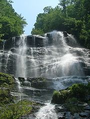
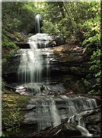
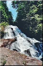
Waterfalls of North Georgia
Encyclopedia
Waterfall
A waterfall is a place where flowing water rapidly drops in elevation as it flows over a steep region or a cliff.-Formation:Waterfalls are commonly formed when a river is young. At these times the channel is often narrow and deep. When the river courses over resistant bedrock, erosion happens...
s of northern Georgia
Georgia (U.S. state)
Georgia is a state located in the southeastern United States. It was established in 1732, the last of the original Thirteen Colonies. The state is named after King George II of Great Britain. Georgia was the fourth state to ratify the United States Constitution, on January 2, 1788...
, U.S.A., are a prominent feature of the geography
Geography
Geography is the science that studies the lands, features, inhabitants, and phenomena of Earth. A literal translation would be "to describe or write about the Earth". The first person to use the word "geography" was Eratosthenes...
of that region, as well as a major focus of tourism and outdoor recreation. Many are located in state parks, national forests, wildlife management areas, and other public lands. Many are accessible—with varying degrees of ease or difficulty—via established hiking trails, and some developed areas include boardwalks, observation platforms, picnic areas, and other amenities. The Cherokee
Cherokee
The Cherokee are a Native American people historically settled in the Southeastern United States . Linguistically, they are part of the Iroquoian language family...
called this region "Land of a Thousand Waterfalls". The third-, fourth-, and fifth-highest waterfalls in the eastern United States are located in northern Georgia.
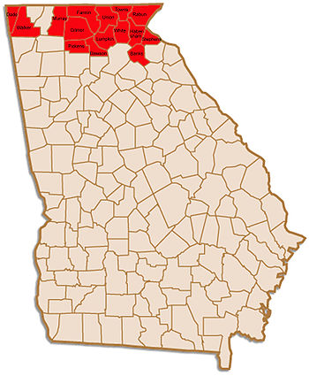
In this discussion, North Georgia refers to the mountainous regions of the extreme northern portion of the state, an area including, among others, Banks
Banks County, Georgia
Banks County is a county located in the U.S. state of Georgia. As of 2010, the population is 18,395. The county seat is Homer.-History:*The Georgia General Assembly passed legislation to create Banks County on February 1, 1859, from Franklin and Habersham Counties.*The county is named for Richard...
, Dade
Dade County, Georgia
Dade County is a county located in the U.S. state of Georgia. As of 2000, the population is 15,154. The 2007 Census Estimate shows a population of 16,098...
, Dawson
Dawson County, Georgia
Dawson County is a county located in the U.S. state of Georgia. It was created on December 3, 1857 from Gilmer and Lumpkin counties. As of 2000, the population is 15,999. The 2007 Census Estimate showed a population of 21,484...
, Fannin
Fannin County, Georgia
Fannin County is a county located in the U.S. state of Georgia. It was created on January 21, 1854. As of 2000, the population was 19,798. The 2007 Census Estimate shows a population of 22,580...
, Gilmer
Gilmer County, Georgia
Gilmer County is a county located in the U.S. state of Georgia. It was created on December 3, 1832 and was named for George Rockingham Gilmer. As of 2000, the population was 23,456. The 2007 Census Estimate shows a population of 28,389...
, Habersham
Habersham County, Georgia
Habersham County is a county located in the U.S. state of Georgia. It was created on December 15, 1818, and named for Colonel Joseph Habersham. As of 2000, the population was 35,902. The 2007 Census Estimate shows a population of 42,272. Clarkesville is the county seat.Chartered in 1823, the...
, Lumpkin
Lumpkin County, Georgia
Lumpkin County is a county located in the U.S. state of Georgia. As of the 2010 census, the population was 29,966. Its county seat is Dahlonega.- History :...
, Murray
Murray County, Georgia
Murray County is a county located in the U.S. state of Georgia. As of 2000, the population was 36,506. The 2007 Census Estimate showed a population of 40,664. The county seat is Chatsworth.It is part of the Dalton, Georgia, Metropolitan Statistical Area....
, Pickens
Pickens County, Georgia
Pickens County is a county located in the U.S. state of Georgia. The 2000 Census showed a population of 22,983. The 2007 Census Estimate showed a population of 30,488...
, Rabun
Rabun County, Georgia
Rabun County is a county located in the U.S. state of Georgia. As of the 2000 census, the population was 15,050. The 2007 Census Estimate shows a population of 16,519...
, Stephens
Stephens County, Georgia
Stephens County is a county located in the U.S. state of Georgia. According to the 2010 Census, the population was 26,175. The 2007 Census Estimate shows a population of 25,268. The county seat is Toccoa.-History:...
, Towns
Towns County, Georgia
Towns County is a county located in the U.S. state of Georgia. It was created on March 6, 1856. As of the 2000 census, the population was 9,319. The 2007 Census Estimate shows a population of 10,894. Its county seat is Hiawassee.-History:...
, Union
Union County, Georgia
Union County is a county located in the U.S. state of Georgia. As of 2000, the population was 17,289. The 2007 Census Estimate shows a population of 20,968. The county seat is Blairsville.Its Sole commissioner is Lamar Paris, who has served since 2001....
, Walker
Walker County, Georgia
Walker County is a county located in the U.S. state of Georgia. It was created on December 18, 1833 from land formerly belonging to the Cherokee Indian Nation. As of 2000, the population was 61,053. The 2007 Census Estimate shows a population of 64,554...
, and White
White County, Georgia
White County is a county located in the northeast corner of the U.S. state of Georgia. It was created on December 22, 1857, from part of Habersham County. The county was named for Newton County Representative David T. White, who helped a Habersham representative successfully attain passage of an...
Counties. There are, of course, waterfalls in other sections of the state; however, due to variations in both climate and terrain they are most abundant and most dramatic in the extreme north.
Falls by county
Those maps, coordinates, and descriptions presented here are meant only to provide approximate or relative locations. Numerous publications and online resources are available to those wishing to visit these sites, both by foot and by vehicle. As many of these sites remain in a relatively wild state caution must be exercised at all times.
Dade County
- Cloudland Canyon Falls 1Cloudland Canyon Falls 1Cloudland Canyon Falls #1 is an unnamed waterfall located in Cloudland Canyon State Park in Dade County, Georgia....
& Cloudland Canyon Falls 2Cloudland Canyon Falls 2Cloudland Canyon Falls #2 is an unnamed waterfall located in Cloudland Canyon State Park in Dade County, Georgia....
—located in Cloudland Canyon State ParkCloudland Canyon State ParkCloudland Canyon State Park is a 3,485 acre Georgia state park located near Trenton and Cooper Heights on the western edge of Lookout Mountain...
near TrentonTrenton, GeorgiaTrenton is a city in Dade County, Georgia, United States. The population was 1,942 at the 2000 census. It is the only incorporated municipality in the county, and as such it serves as the county seat....
, in a deep gorge on Sitton Gulch Creek. (Trailhead: 34°50.07′N 85°28.90′W)
Dawson County
- Amicalola Falls—at 729 feet (222.2 m) Amicalola Falls is the highest waterfall in Georgia and the third highest east of the Mississippi RiverMississippi RiverThe Mississippi River is the largest river system in North America. Flowing entirely in the United States, this river rises in western Minnesota and meanders slowly southwards for to the Mississippi River Delta at the Gulf of Mexico. With its many tributaries, the Mississippi's watershed drains...
. It is approximately four times the height of Niagara'sNiagara FallsThe Niagara Falls, located on the Niagara River draining Lake Erie into Lake Ontario, is the collective name for the Horseshoe Falls and the adjacent American Falls along with the comparatively small Bridal Veil Falls, which combined form the highest flow rate of any waterfalls in the world and has...
Horseshoe FallsHorseshoe FallsThe Horseshoe Falls, also known as the Canadian Falls, is part of Niagara Falls, on the Niagara River. Approximately 90% of the Niagara River, after diversions for hydropower generation, flows over Horseshoe Falls. The remaining 10% flows over the American Falls...
. It is located on Amicalola Creek in Amicalola Falls State ParkAmicalola Falls State ParkAmicalola Falls State Park is an 829 acre Georgia state park located between Ellijay and Dahlonega in Dawsonville, Georgia. The park's name is derived from a Cherokee language word meaning "tumbling waters". The park is home to Amicalola Falls, a 729-foot waterfall, making it the highest in...
and is accessible via several trails, bridges, and parking areas. Visitors may park at either the top or the base of the falls; a well-maintained trail, including over 600 steps, connects those two points. Another trail connects the falls to the terminus of the Appalachian TrailAppalachian TrailThe Appalachian National Scenic Trail, generally known as the Appalachian Trail or simply the AT, is a marked hiking trail in the eastern United States extending between Springer Mountain in Georgia and Mount Katahdin in Maine. It is approximately long...
on nearby Springer MountainSpringer MountainSpringer Mountain is located in the Chattahoochee National Forest in Fannin County of northern Georgia. It is now the southern terminus of the Appalachian Trail.-Geography:The mountain's peak is at above mean sea level.-Appalachian Trail:...
. Some sources, including the 2004 Georgia State Parks guide book, claim that Amicaolola Falls are "the tallest east of the Mississippi RiverMississippi RiverThe Mississippi River is the largest river system in North America. Flowing entirely in the United States, this river rises in western Minnesota and meanders slowly southwards for to the Mississippi River Delta at the Gulf of Mexico. With its many tributaries, the Mississippi's watershed drains...
," although Crabtree FallsCrabtree FallsCrabtree Falls is located in the George Washington National Forest in Nelson County, Virginia, and is one of the tallest sets of waterfalls in the United States east of the Mississippi River. The name of the falls is thought to have come from William Crabtree, who settled in this part of Virginia...
in VirginiaVirginiaThe Commonwealth of Virginia , is a U.S. state on the Atlantic Coast of the Southern United States. Virginia is nicknamed the "Old Dominion" and sometimes the "Mother of Presidents" after the eight U.S. presidents born there...
(at 1000 feet) and Glassmine FallsGlassmine FallsGlassmine Falls is an ephemeral waterfall in Buncombe County, North Carolina, on Glassmine Branch, near Dillingham, North Carolina.-Geology:When it flows, the falls slides down the rock face of Blackstop Knob Mountain down to the North Fork Swannanoa River. The flow is not constant and can...
in North CarolinaNorth CarolinaNorth Carolina is a state located in the southeastern United States. The state borders South Carolina and Georgia to the south, Tennessee to the west and Virginia to the north. North Carolina contains 100 counties. Its capital is Raleigh, and its largest city is Charlotte...
(800 feet) are both taller. (The state park website is more specific—and perhaps more accurate—citing Amicalola as "the tallest cascading waterfall". More recent editions of the print version of the guide have corrected the error.) (34°33.81′N 84°14.66′W) - Bearden Falls—located in the Chattahoochee National Forest on Bearden Creek. (34°36.48′N 84°11.77′W)
- Cochrans Falls—at 600 feet (182.9 m), Cochrans FallsCochrans FallsWith a total vertical drop of 600 feet , Cochrans Falls is tied with Caledonia Cascade as the second tallest waterfall in Georgia. This cascading waterfall is located in Dawson County, northwest of Dawsonville, Georgia and is in the vicinity of the tallest waterfall in the state, Amicalola Falls...
is tied with Caledonia CascadeCaledonia CascadeCaledonia Cascade, sometimes called Cascade Falls, is a waterfall located in Rabun County, Georgia, USA near the town of Tallulah Falls. This waterfall occurs on a small stream that drops into the Tallulah Gorge near the beginning of the gorge. This tiered waterfall features three drops, the...
as the second highest waterfall in Georgia. It is on Cochrans Creek near DawsonvilleDawsonville, GeorgiaDawsonville is a city in Dawson County, Georgia, United States. The population was 619 at the 2000 census. The city is the county seat of Dawson County...
. (34°34.52′N 84°12.97′W) - Crawford Falls—located on private property and not accessible to the public.
- "Edge of the World" Rapids—Class IV rapids on the Amicalola River. (Parking area: 34°25.60′N 84°12.80′W)
- Falls Creek Falls—located in the Dawson Forest, an area containing at least forty three waterfalls. (Upper Falls:34°30.78′N 84°19.42′W; Falls Creek Falls:34°30.94′N 84°19.11′W; Lower Falls:34°30.79′N 84°18.43′W)
- Lower Falls & Upper Falls—located on Disharoon Creek in the southwest corner of Dawson County, near the gated community of Big Canoe. (34°28.36′N 84°19.12′W)
Fannin County
- Jacks River Falls—on Jacks River in the Cohutta Wilderness Area. (34°58.29′N 84°34.37′W)
- Little Rock Creek Falls—in the Chattahoochee National Forest.
- Long Creek Falls—located near the Appalachian Trail near Three Forks.
- Noontootla Falls—on a small tributary of Noontootla Creek near Three Forks. (34°51.20′N 84°11.64′W)
- Sea Creek Falls—in the Cooper Creek area in eastern Fannin County, near the Union County line. (34°46.19′N 84°5.71′W)
Gilmer County
- Barnes Creek Falls—in the Cohutta Wilderness Area near Murray County line; nearby mountaintop offers commanding view of the valley and Fort Mountain. (34°49.57′N 84°34.94′W)
- Falls on Davis Creek—located on private property but can be viewed from Pleasant Hill Road (State Route 59) near the community of Pleasant Hill.
- Falls Branch Falls—twin falls, "Lower" and "Upper", on Falls Branch near its confluence with Stanley Creek in northeast Gilmer, near the Fannin County line. (34°47.04′N 84°18.13′W)
- Julie Anna Falls—a fifty-foot falls on Turniptown Creek in the Rich Mountain Wilderness Area of the Chattahoochee National Forest. (34°44.05′N 84°21.10′W)
- Tumbling Waters—Tails Creek falls 75 feet (22.9 m) in a series of cascades on its approach to Carters Lake.
Habersham County
- Panther Creek Falls—located in the Panther Creek Recreation Area between ClarkesvilleClarkesville, GeorgiaClarkesville is a city located in the center of Habersham County, Georgia. It is also the county seat.-Geography:Clarkesville is located at ....
and Tallulah FallsTallulah Falls, GeorgiaTallulah Falls is a town in Habersham and Rabun counties in the U.S. state of Georgia near the Tallulah River. The population was 164 at the 2000 census...
. (34°40.63′N 83°23.29′W) - Shoals on Soque RiverSoque RiverThe Soque River and its watershed are located entirely within the county boundaries of Habersham County in northeast Georgia. The Soque is a tributary of the Chattahoochee River. Portions of the river run along State Route 197.The highest point in the watershed occurs on Tray Mountain...
—located on private property but readily accessible to the public. The Mark of the Potter, a potters' cooperative on Highway 197, occupies an old mill beside the Shoals, which can be viewed from the co-op's balcony. Coin-operated machines dispense food for fish and waterfowl. (34°43.78′N 83°35.35′W) - Miner Shoals-located on private property, not accessible to the public. 48 feet (14.6 m) near vertical drop. "By far the best waterfall on the river" as stated by State Geologist S. W. McCallie in his Water Powers of Georgia, 1908.
Lumpkin County
- Black Falls—on the grounds of Camp Frank D. Merrill, a Mountain Ranger camp 11 miles (17.7 km) north of Dahlonega. Public access may be restricted.
- Blood Mountain Creek Falls—four falls (Lower Falls, Middle Falls, Upper Falls, and Cascade). (Trailhead for two lower falls: 34°41.87′N 83°57.18′W; for two upper falls: 34°42.40′N 83°57.30′W)
- Cane Creek Falls—located on the grounds of Camp Glisson, a camp operated by the United Methodist ChurchUnited Methodist ChurchThe United Methodist Church is a Methodist Christian denomination which is both mainline Protestant and evangelical. Founded in 1968 by the union of The Methodist Church and the Evangelical United Brethren Church, the UMC traces its roots back to the revival movement of John and Charles Wesley...
near DahlonegaDahlonega, GeorgiaDahlonega is a city in Lumpkin County, Georgia, United States, and is its county seat. As of the 2010 census, the city had a population of 5,242....
, these falls are often (but not always) open to the public. - Cannon Falls— located on Frogtown Creek, on the grounds of Cannon Falls Lodge, a private fishing preserve, and only accessible with a guide.
- Clay Creek Falls—located on private property but easily viewed from Clay Creek Falls Road, just outside the city limits of Dahlonega. (34°32.26′N 84°1.32′W)
- Copper Mine Shoals—there are several rapid drops on the Chestatee RiverChestatee RiverThe Chestatee River is a river in the Appalachian Mountains of northern Georgia, USA. It begins at the confluence of Dicks Creek and Frogtown Creek The Chestatee River (variant spellings Chestatie, Chestetee, Chostatee, Chosteta, none in modern use) is a river in the Appalachian Mountains of...
north of Dahlonega. - Cow Rock Creek Falls—near Boggs Creek Campground in the Chattahoochee National Forest. (34°42.66′N 83°52.90′W)
- DeSoto FallsDeSoto Falls (Georgia)The DeSoto Falls of Georgia are located in Lumpkin County, Georgia along Frogtown Creek. There are actually three waterfalls on Frogtown Creek, called Upper DeSoto Falls, Middle Desoto Falls and Lower DeSoto Falls. The upper waterfall drops , the middle waterfall drops and the lower waterfall...
—a pair of falls on Frogtown Creek in the DeSoto Falls Scenic Area of the Chattahoochee National Forest. According to legend, Hernando de SotoHernando de Soto (explorer)Hernando de Soto was a Spanish explorer and conquistador who, while leading the first European expedition deep into the territory of the modern-day United States, was the first European documented to have crossed the Mississippi River....
passed through the area in 1540. (34°42.37′N 83°54.95′W) - Dicks Creek Falls—a pair of falls just below the site where Waters Creek joins Dicks Creek in the Chattahoochee National Forest. (34°40.782′N 83°56.202′W)
- Elvarado Falls—not open to the public.
- Etowah River Shoals—the Etowah RiverEtowah RiverThe Etowah River is a waterway that rises northwest of Dahlonega, Georgia, north of Atlanta. Its name is the Cherokee version of the original Muskogee word Etalwa, which means a "trail crossing". On Matthew Carey's 1795 map the river was labeled "High Town River"...
rises in Lumpkin County, northwest of Dahlonega - Falls on Branch of Jones Creek—located in the Chattahoochee National Forest and easily accessible. (34°36.618′N 84°9.45′W)
- Falls on West Fork of Montgomery Creek—twenty-foot falls on the grounds of a US Army Ranger Camp. (34°37.452′N 84°6.9′W)
- Grindle Shoals—on private property along the Chestatee River but viewable from the bridge carrying Cavender Creek Road across the Chestatee in eastern Lumpkin, near the White County line. (34°33.6′N 83°52.26′W)
- High Shoals Falls—on Walden Creek; features a porch swing from which to view the falls. (34°38.91′N 84°1.332′W)
- Jones Creek Falls
- Little Ridge Creek Falls—a trio of falls near Boggs Creek Campground in the Chattahoochee National Forest. (34°42.42′N 83°53.4′W)
- Martha Falls—on Pigeon Roost Creek; the area features spectacular lake and mountain views. (34°41.37′N 83°58.83′W)
- Trophy Falls— located on Frogtown Creek, on the grounds of Cannon Falls Lodge, a private fishing preserve, and only accessible with a guide.
- Ward Creek Falls—near Justus Gap, northwest of Dahlonega.
- Yahoola Creek Falls—just before the Yahoola Creek leaves the Chattahoochee National Forest. The remnants of Nineteenth Century gold-mining operations are nearby.
Murray County
- Jigger Falls—on Jigger Creek, in the Cohutta Wilderness Area.
- Mill Creek Falls—falls, shoals, and cascade on Mill Creek in Hickey Gap. Conasauga Lake, a high mountain lake, sits nearby. (Falls parking area: 34°53.61′N 84°40.26′W)
Pickens County
- Long Swamp Creek Falls—sixty-foot falls located on private property; access may be granted by land owners. (34°29.25′N 84°23.232′W)
Rabun County
Eastern Continental Divide
The Eastern Continental Divide, in conjunction with other continental divides of North America, demarcates two watersheds of the Atlantic Ocean: the Gulf of Mexico watershed and the Atlantic Seaboard watershed. Prior to 1760, the divide represented the boundary between British and French colonial...
passes through the county, which has a number of peaks whose heights surpass 4000 feet (1,219.2 m) above sea level
Sea level
Mean sea level is a measure of the average height of the ocean's surface ; used as a standard in reckoning land elevation...
) but is also one of the rainiest areas east of the Mississippi River. These factors combine to produce many dramatic falls.
- Ada-Hi FallsAda-Hi FallsAda-Hi Falls is located within Black Rock Mountain State Park in Rabun County, Georgia. The name is Cherokee for "forest." It is the highest elevation falls in the state. The amount of water present is highly variable due to its high elevation. The falls are surrounded by a forest of rhododendron....
—in Black Rock Mountain State ParkBlack Rock Mountain State ParkBlack Rock Mountain State Park is a 1,743 acre Georgia state park located west of Mountain City in Rabun County. It is named after its sheer cliffs of dark-colored biotite gneiss and encompasses some of the most outstanding countryside in Georgia's Blue Ridge Mountains...
; features an observation deck and nearby mountain overlooks. - Ammons Creek FallsAmmons Creek FallsAmmons Creek Falls is a waterfall located in the Tallulah Ranger District of the Chattahoochee National Forest in Rabun County, Georgia that cascades for over 100 feet. There is 1.75 mile loop hiking trail that provides access to both nearby Holcomb Creek Falls and Ammons Creek Falls...
—the trail to Holcomb Creek Falls is atwo-mile loop that also leads to a viewing deck at Ammons Creek Falls. - Angel Falls (Georgia)Angel Falls (Georgia)Angel Falls is the second of two waterfalls on the Angel Falls Trail in Rabun County, Georgia. The first waterfall on the trail is Panther Falls ....
—on Joe Branch Creek near Lake RabunLake RabunLake Rabun is a twisty reservoir with of shoreline located in the Northeastern corner of Georgia in Rabun County. It is the third lake in a six-lake series that follows the original course of the Tallulah River. The series begins with Lake Burton as the northernmost lake, followed by Lake Seed,...
, surrounded by rhododendron; on the same trail as, and about one half mile beyond Panther Falls. - Bad Branch FallsBad Branch FallsBad Branch Falls is located in Rabun County, Georgia. It is near Lake Rabun and Lake Seed....
—an easy walk from the trailhead. Georgia Power Company maintains a recreation area near the trailhead. (34°59′N 83°20′W) - Becky Branch Falls—on the Bartram TrailBartram TrailThe Bartram Trail follows the approximate route of 18th-century naturalist William Bartram’s southern journey from March, 1773 to January, 1777. Bartram explored much of the territory which is now the states of North and South Carolina, Georgia, Florida, Alabama, Mississippi, Louisiana and...
in Warwoman DellWarwoman DellWarwoman Dell is a wooded valley or dell located east of Clayton, Georgia in Rabun County.-Name:Warwoman Dell and the Warwoman Creek, which flows through the valley, are named after a woman that the Cherokee called “warwoman.” There is some degree of controversy as to which of two women from...
. (34°53.04′N 83°21.15′W) - Big Creek Falls—(34°59′N 83°11.6′W)
- Bull Sluice Rapids—Class V Rapids on the Chattooga River; the location is actually best approached from the South Carolina side of the river. (34°48.86′N 83°18.38′W)
- Caledonia CascadeCaledonia CascadeCaledonia Cascade, sometimes called Cascade Falls, is a waterfall located in Rabun County, Georgia, USA near the town of Tallulah Falls. This waterfall occurs on a small stream that drops into the Tallulah Gorge near the beginning of the gorge. This tiered waterfall features three drops, the...
—also known as Cascade Falls, at 600 feet (182.9 m) in height it is tied (with Cochrans FallsCochrans FallsWith a total vertical drop of 600 feet , Cochrans Falls is tied with Caledonia Cascade as the second tallest waterfall in Georgia. This cascading waterfall is located in Dawson County, northwest of Dawsonville, Georgia and is in the vicinity of the tallest waterfall in the state, Amicalola Falls...
) as the second-tallest waterfall in Georgia. It is located on a small stream that joins the Tallulah River near the beginning of the Tallulah Gorge. - Crow Creek Falls—a series of falls, one visible from Crow Creek Road, another approximately 300 yards from the road.
- Darnell Falls (NA)
- Dick's Creek FallsDick's Creek FallsDick's Creek Falls is a waterfall that features a drop of Dicks Creek into the Chattooga River. Located in the Chattahoochee National Forest, it is reached by using the Dick's Creek Trail, which is short trail that connects to the Bartram Trail in eastern Rabun County, Georgia.To reach the...
—60-foot falls where Dick’s Creek meets the Chattooga RiverChattooga RiverThe Chattooga River is the main tributary of the Tugaloo River. Its headwaters are located southwest of Cashiers, North Carolina, and it stretches to where it has its confluence with the Tallulah River within Lake Tugalo, held back by the Tugalo Dam...
, which marks the border with South CarolinaSouth CarolinaSouth Carolina is a state in the Deep South of the United States that borders Georgia to the south, North Carolina to the north, and the Atlantic Ocean to the east. Originally part of the Province of Carolina, the Province of South Carolina was one of the 13 colonies that declared independence...
; located in the Chattooga National Wild and Scenic River Area. (34°52.07′N 83°14.77′W) - Dolly Falls (NA)
- Estatoah FallsEstatoah FallsEstatoah Falls are located on Mud Creek in Rabun County, Georgia. The falls are located on private property and are not open to the public. The falls may be viewed from several places along State Route 246. There are also some smaller falls near Sky Valley, Georgia called Little Estatoah Falls...
—on private property but may be viewed from several points along Highway 246. (34°59.46′N 83°20.88′W) - Hemlock Falls & Upper Falls—on Moccasin Creek in Moccasin Creek State ParkMoccasin Creek State ParkMoccasin Creek State Park is a state park located on the western shore of Lake Burton in Rabun County in the northeast corner of Georgia. The park features campgrounds; a fishing pier for the physically disabled, the elderly, and children; and walking trails...
. (34°51.151′N 83°36.655′W)

- Upper Falls on Holcomb CreekHolcomb Creek FallsHolcomb Creek Falls, located in the Chattooga River Ranger District of the Chattahoochee National Forest in Rabun County, Georgia, drop 120 feet over shoals. There is 1.75 mile loop hiking trail that provides access to both Holcomb Creek Falls and nearby Ammons Creek Falls...
—several hundred feet of cascades on Holcomb Creek. The approach includes a viewing platform. - Kilby Mill Falls—(Parking area: 34°56.84′N 83°29.66′W)
- Laural Falls—on the grounds of Kingswood Golf Course in ClaytonClayton, GeorgiaClayton is a city in Rabun County, Georgia, United States. The population was 2,019 at the 2000 census. The city is the county seat of Rabun County and is located in the Blue Ridge Mountains.-History:...
. - Martin Creek Falls—features an observation deck. (34°53.568′N 83°20.961′W)
- Minnehaha FallsMinnehaha Falls, GeorgiaMinnehaha Falls cascade about 100 feet over a stair-stepped rock formation. They are located on Falls Creek in Rabun County, Georgia within the boundaries of the Chattahoochee National Forest in the Chattooga River Ranger District and are near Lake Rabun. The falls can be reached by a short trail...
—100 foot falls near the Lake SeedLake SeedLake Seed is a 240 acre reservoir with 13 miles of shoreline located in Rabun County, in the northeastern corner of Georgia, USA. It is the second lake in a series of six lakes that follow the original riverbed of the Tallulah River. Each lake in the chain is created by hydroelectric dams...
Dam and Rabun Beach Recreation AreaLake RabunLake Rabun is a twisty reservoir with of shoreline located in the Northeastern corner of Georgia in Rabun County. It is the third lake in a six-lake series that follows the original course of the Tallulah River. The series begins with Lake Burton as the northernmost lake, followed by Lake Seed,...
; the falls are a short hike from a small parking area. Minnehaha Falls graced the cover of the 2007 Georgia Travel Guide. (34°44.85′N 83°28.84′W) - Mud Creek Falls—within the gated community of Sky ValleySky Valley, GeorgiaSky Valley is a town in Rabun County, Georgia, United States and is nestled in a scenic mountain valley on the northwest slopes of Rabun Bald, Georgia's second-highest peak. As of the 2000 census, the city had a total population of 250....
, below the dam and golf course. (34°59′N 83°20′W) - Panther FallsPanther Falls (Georgia)Panther Falls is the first of two waterfalls on the Angel Falls Trail in Rabun County, Georgia. The second waterfall on the trail is Angel Falls....
—near Rabun Beach Camping Area #2; the trail continues beyond Panther Falls to the larger Angel Falls. - Singley's Falls—Overflow Creek drops 150 feet (45.7 m) to meet Big Creek and Holcomb Creek, forming the West Fork of the Chattooga River. (34°58.5′N 83°13.24′W)
- Stonewall Creek Falls—there is a primitive camp ground at the base of the falls. (34°49.232′N 83°27.001′W)
- Sylvan Mill Falls— located at the Sylvan Falls Mill Bed & Breakfast in Mountain CityMountain City, GeorgiaMountain City is an incorporated town in Rabun County, Georgia, United States. The population was 829 at the 2000 census. The town straddles the Eastern Continental Divide in a deep gap in the Blue Ridge Mountain front. The gap allows U.S...
. Although the falls are on private property they may be viewed from the road. (34°55.66′N 83°25.21′W) - Tallulah Gorge State ParkTallulah Gorge State ParkTallulah Gorge State Park is a Georgia state park adjacent to Tallulah Falls, Georgia along the county line between Rabun and Habersham Counties. The park surrounds Tallulah Gorge, a deep gorge formed by the action of the Tallulah River, which runs along the floor of the gorge...
—managed jointly by the Georgia State Parks system and Georgia Power Company, the latter of which operates the hydroelectric dam above the 600 feet (182.9 m)-deep Tallulah GorgeTallulah GorgeThe Tallulah Gorge is a gorge that is formed by the Tallulah River cutting through the Tallulah Dome rock formation. The gorge is approximately long and features rocky cliffs up to high. Through it, a series of falls known as Tallulah Falls, drop a total of in one mile...
. The Tallulah RiverTallulah RiverThe Tallulah River is a river in Georgia and North Carolina. It begins in Clay County, North Carolina, near Standing Indian Mountain in the Southern Nantahala Wilderness and flows south into Georgia, crossing the state line into Towns County. The river then travels through Rabun County and ends in...
flows over six major falls between the Tallulah Lake Dam and Lake Tugaloo. Since the dam was built in 1913 only a fraction of the natural volume of water flows through the gorge, but on scheduled “whitewater weekends” in April and November the amount may increase by more than tenfold. Other "aesthetic releases" are sometimes staged. Access to the floor of the gorge is controlled by permit. (Parking area: 34°44.419′N 83°23.388′W)
- L'Eau d'Or Falls—46-foot falls.
- Tempesta Falls—76-foot falls.
- Hurricane Falls—96-foot falls.
- Oceana Falls—50-foot falls.
- Bridal Veil—17-foot falls flows over a smooth "sliding rock" popular with visitors who use it as a natural water slide.
- Sweet Sixteen—16-foot falls.
- Three Forks—located in the Chattooga Wild and Scenic River Area; Holcomb Creek, Overflow Creek and Big Creek meet at Three Forks to form the West Fork of the Chattooga River. (34°58.1′N 83°12.80′W)
- Timpson Creek Falls—located near Clayton and the Chatahoochee National Forest; may be on private property. (34°53.30′N 83°28.94′W)
- Wildcat Creek Falls—visible from West Wildcat Road (Fire Service Road 127). (34°50.1′N 83°36.30′W)
Stephens County
- Toccoa FallsToccoa FallsWith a vertical drop of , the Toccoa Falls waterfall is located on the campus of Toccoa Falls College in Stephens County, Georgia. Toccoa is the Cherokee Indian name for "beautiful"....
—dramatic 186 feet (56.7 m) falls located on the grounds of Toccoa Falls CollegeToccoa Falls CollegeToccoa Falls College is a fully accredited, Christian liberal arts, bible college, located in Toccoa, Georgia, on the edge of the Piedmont region and in the foothills of the Blue Ridge Mountains. The campus occupies , bordering the Chattahoochee National Forest and is home to Toccoa Falls a high...
in the city of ToccoaToccoa, GeorgiaToccoa is a city in Stephens County, Georgia, United States located approximately from Athens and approximately northeast of Atlanta. The population was 9,323 at the 2000 census...
. The falls may be reached by a short, paved pathway and are accessible to the handicapped. The college charges a nominal fee for admission to the site. Toccoa Falls has erroneously been billed as the tallest free-falling waterfall in the Eastern United States and simply "the highest waterfall east of the Mississippi River". (The latter claim was previously included at the Toccoa Falls College website. More than a dozen eastern waterfalls are, in fact, taller than Toccoa Falls; Crabtree FallsCrabtree FallsCrabtree Falls is located in the George Washington National Forest in Nelson County, Virginia, and is one of the tallest sets of waterfalls in the United States east of the Mississippi River. The name of the falls is thought to have come from William Crabtree, who settled in this part of Virginia...
in VirginiaVirginiaThe Commonwealth of Virginia , is a U.S. state on the Atlantic Coast of the Southern United States. Virginia is nicknamed the "Old Dominion" and sometimes the "Mother of Presidents" after the eight U.S. presidents born there...
is actually the tallest waterfall in the eastern US, and Fall Creek FallsFall Creek Falls State ParkFall Creek Falls State Resort Park is a state park in Middle Tennessee, located between Pikeville and Spencer. The park spans the boundary between Van Buren and Bledsoe counties....
in TennesseeTennesseeTennessee is a U.S. state located in the Southeastern United States. It has a population of 6,346,105, making it the nation's 17th-largest state by population, and covers , making it the 36th-largest by total land area...
features the highest free-fall. A more recent edition of the college website states--correctly--that Toccoa Falls are higher than Niagara FallsNiagara FallsThe Niagara Falls, located on the Niagara River draining Lake Erie into Lake Ontario, is the collective name for the Horseshoe Falls and the adjacent American Falls along with the comparatively small Bridal Veil Falls, which combined form the highest flow rate of any waterfalls in the world and has...
.) In 1977 a dam breakKelly Barnes DamKelly Barnes Dam was an earthen embankment dam once located in Stephens County, Georgia, just outside of the city of Toccoa. It collapsed on November 6, 1977 after a period of heavy rainfall, and the resulting flood killed 39 people and caused $2.8 million in damages...
just above the falls devastated the college and caused thirty nine deaths. The site includes a memorial to those who perished. (34°35.64′N 83°21.666′W)
Towns County
- Blue Hole FallsBlue Hole FallsBlue Hole Falls located on High Shoals Creek in the High Shoals Scenic Area of the Chattahoochee National Forest in Towns County, Georgia, USA....
and High Shoals Creek FallsHigh Shoals Creek FallsHigh Shoals Creek Falls located on High Shoals Creek in the High Shoals Scenic Area of the Chattahoochee National Forest in Towns County, Georgia and features two observation decks....
—located on High Shoals Creek in the High Shoals Scenic Area of the Chattahoochee National Forest; features two observation decks. (34°48.972′N 83°43.62′W) - Denton Branch Falls—easily-accessible thirty-foot falls located near Tate CityTate City, GeorgiaTate City is an unincorporated community in Towns County, Georgia, United States. It was founded as a mining and logging community.Tate City sits in a scenic valley along the upper Tallulah River, just south of the Georgia-North Carolina border. The community is flanked by various peaks of the...
; the approach reveals numerous smaller falls and shoals. (34°59.142′N 83°33.00′W) - Cupid Falls—near Young Harris CollegeYoung Harris CollegeYoung Harris College is a private, Methodist-affiliated liberal arts college located in the mountains of northeast Georgia. The current president is Cathy Cox, former Georgia Secretary of State.-Origins:...
in Young HarrisYoung Harris, GeorgiaYoung Harris is a city in Towns County, Georgia, United States. The population was 604 at the 2000 census. Young Harris is home to Young Harris College, after which it was named.-Geography:Young Harris is located at ....
. (34°56.1′N 83°50.34′W) - Enota Mountain Retreat & Conference Center—the grounds of this facility in HiawasseeHiawassee, GeorgiaHiawassee is a town in and the county seat of Towns County, Georgia, United States. The population was 810 at the 2000 census. Its name comes from the Cherokee word Ayuhwasi, which means a meadow.-Geography:...
contain several falls; visitors must obtain permission before accessing the property.
- Gurley Creek Falls—220-foot falls viewable from an observation deck a short walk from the visitors center. (34°50.298′N 83°46.8′W)
- Joel Creek Falls—a ten-minute walk from the visitors center. (34°50.1′N 83°46.602′W)
Union County
- Canada Creek Falls–there are several falls on Canada Creek, both within the boundaries of the Chattahoochee National Forest and after the creek enters private lands. The Upper Falls are on public land, above the confluence of the Wildhog Creek and Canada Creek. (Upper Falls: 34°41.44′N 84°02.53′W; other falls: 34°41.04′N 84°03.82′W)
- Falls on the Upper Chattahoochee—on the headwaters of the Chattahoochee River, which rushes through a two-foot-wide channel at one point. (Parking area: )
- Helton Creek FallsHelton Creek FallsHelton Creek Falls is a series of 2 waterfalls located within in the Chattahoochee National Forest in Union County, Georgia....
–a pair of falls in a rhododendronRhododendronRhododendron is a genus of over 1 000 species of woody plants in the heath family, most with showy flowers...
grove in the Chattahoochee National Forest; the approach includes a well-maintained stairway and an observation platform. (34°45.2′N 83°53.7′W) - Horsetrough FallsHorsetrough FallsHorsetrough Falls are located on one of the flanks of Horsetrough Mountain in Union County, Georgia. This 70 foot waterfall is located on a creek that is part of the headwaters of the Chattahoochee River and is in the Mark Trail Wilderness. There is an observation platform at the falls which can...
–an easily-accessible falls located where Horsetrough Creek joins the headwaters of the Chattahoochee RiverChattahoochee RiverThe Chattahoochee River flows through or along the borders of the U.S. states of Georgia, Alabama, and Florida. It is a tributary of the Apalachicola River, a relatively short river formed by the confluence of the Chattahoochee and Flint Rivers and emptying into Apalachicola Bay in the Gulf of...
, in the southeast corner of the county; the approach includes a footbridge which is the first bridge on the Chattahoochee. (34°47.53′N 83°47.24′W) - Lake Trahlyta SpillwayLake Trahlyta SpillwayLake Trahlyta Spillway is located in Union County, Georgia, USA. It is located within Vogel State Park. It is named for Trahlyta, a Cherokee maiden who is buried a few miles from the park at Stonepile Gap....
–on Wolf Creek just below the dam in Vogel State ParkVogel State ParkVogel State Park is a or 94 hectares state park located at the base of Blood Mountain in the Chattahoochee National Forest. It became one of the first two parks in Georgia when it founded a state park system in 1931. Much of the park was constructed by the Civilian Conservation Corps during the...
; the approach includes a boardwalk trail and an observation platform.
Walker County
- Glen Falls—a series of small falls on Lookout Mountain near ChattanoogaChattanooga, TennesseeChattanooga is the fourth-largest city in the US state of Tennessee , with a population of 169,887. It is the seat of Hamilton County...
, close to the TennesseeTennesseeTennessee is a U.S. state located in the Southeastern United States. It has a population of 6,346,105, making it the nation's 17th-largest state by population, and covers , making it the 36th-largest by total land area...
line, maintained by the National Park Service. - Keown Falls—located in the Keown Falls Scenic Area near the cities of VillanowVillanow, GeorgiaVillanow, Georgia is located in the Northwestern part of that state in Walker County. It is between Dalton and La Fayette, Georgia. It is a small community of a few hundred citizens only.-Villanow Country Store:...
and LaFayetteLaFayette, GeorgiaLaFayette is a city in Walker County, Georgia, United States. As of the 2000 Census, the city population was 6,702. The city is the county seat of Walker County.LaFayette is part of the Chattanooga, TN–GA Metropolitan Statistical Area.-Geography:...
, the falls flow over a wide cliff, sometimes as a narrow, freefalling ribbon of water. (34°36.80′N 85°05.70′W) - Lula Falls—two falls on Rock Creek, on Lookout MountainLookout Mountainthumb|right|See seven statesLookout Mountain is located at the northwest corner of the U.S. state of Georgia, the northeast corner of Alabama, and along the southern border of Tennessee at Chattanooga. Lookout Mountain, along with Sand Mountain to the northwest, makes up a large portion of the...
. The property is owned by the Lula Lake Land Trust and the public is welcome on the first and last Saturday of every month. Other unusual geological features can be found on the property. (34°55.96′N 85°22.34′W) - Pocket Branch Falls—Pocket Branch flows out of a canyon on the west side of Pigeon Mountain, in the Pigeon Mountain Wildlife Management Area. The Shirley Miller Wildflower Trail is a boardwalk trail below the falls. (Parking area: 34°42.75′N 85°22.80′W)
White County
- Anna Ruby FallsAnna Ruby FallsAnna Ruby Falls is located near Unicoi State Park in White County near Helen, Georgia. The waterfall is accessible via a half mile trail from a public use area with a small admittance charge...
—actually two separate falls, one on Curtis Creek and the other on York Creek, but known together as Anna Ruby Falls. Combined, they form Smith Creek. Located in a grove of mountain laurel in the Anna Ruby Falls Scenic Area in the Chattahoochee National Forest. There is a visitors center and an interpretive walk from there to the falls. (34°45.83′N 83°42.73′W) - Duke's CreekDukes CreekDukes Creek is the creek in White County, Georgia on which gold was found in 1828. Either Frank Logan or one of his slaves is typically given the credit for this find. The discovery of gold in White County and neighboring Lumpkin County led to the Georgia Gold Rush...
Falls—actually on Davis Creek, where it meets Dodd Creek to form Duke's Creek; there is an easy approach featuring boardwalk trails and several observation decks. At least one deck is wheelchair accessible. (Parking Area: 34°42.105′N 83°47.361′W) - Falls near Unicoi Gap—just off Fire Service Road 44.
- Falls on Dodd Creek—at Dukes Creek Falls.
- Falls on Low Gap Creek—off Fire Service Road 44A near Robertstown. (34°44.60′N 83°47.84′W)
- Raven Cliff FallsRaven Cliff Falls (Georgia)Raven Cliff Falls are located in White County, Georgia on a creek that joins Dodd Creek. The waterfall consists of three drops, a drop, followed by a drop into a deep pool, followed by a cascade of to Dodd Creek. The waterfall is an unusual double cascade flowing down through a fissure in a...
—the approach, through rhododendron and hemlock passes many smaller falls; located within the Mark Trail Wilderness Area near the Richard Russell Scenic Highway. (34°43.38′N 83°49.44′W) - Upper Falls on Davis Creek
External links
- Waterfalls of North Georgia
- Georgia's Online Outdoor Recreation and Adventure Guide
- Cloudland Canyon State Park
- Amicalola Falls State Park and Lodge
- Chattahoochee-Oconee National Forests
- Cohutta Wilderness Area
- Dawson Forest WMA
- Panther Creek Recreation Area
- Mark of the Potter
- Camp Frank D. Merrill of the 5th Ranger Training Battalion
- Camp Glisson
- Cannon Falls Lodge
- Toccoa Falls College
- Young Harris College
- Enota Mountain Retreat and Conference Center
- Black Rock Mountain State Park
- Georgia Power
- Moccasin Creek State Park
- Tallulah Gorge State Park