
Springer Mountain
Encyclopedia
Springer Mountain is located in the Chattahoochee National Forest in Fannin County
of northern Georgia
. It is now the southern terminus of the Appalachian Trail
.

approximately 14 miles (22.5 km) to the northeast to Springer Mountain because of increased development around Mount Oglethorpe. The most popular approach trail to Springer Mountain starts at the visitor's center of Amicalola Falls State Park
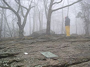
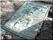
and is 8.3 miles (13.4 km) in length. There is also another .9 mile trail leading from a parking lot on a forest service road to the starting point. At the peak of Springer Mountain is a bronze plaque with the Appalachian Trail logo, a register for hikers to sign, and a benchmark. An open-front trail shelter is provided for hikers.
There is a fire circle and wooden picnic table in front (west) of the shelter. There is a three-walled privy down the hill directly behind the shelter. There is a piped spring about 30 yards (25 m) south of shelter. The spring has provided water even in recent drought years. There are two sturdy cables strung in trees near the shelter. Each is equipped with pulleys and hoisting lines for hauling backpacks and food bags out of reach of the local bears, raccoons and rodents.
There is a meadow with room for many tents near the intersection of the Appalachian Trail and the spur trail to the shelter. The meadow also has a fire circle.
The southern terminus of the Benton MacKaye Trail
(84.19362W, 34.62963N) is about one hundred yards north of the shelter's spur trail's junction. A bronze plaque honors Benton MacKaye
. The plaque is on a rock by the Benton MacKaye Trail a few yards east of the Appalachian Trail.
Fannin County, Georgia
Fannin County is a county located in the U.S. state of Georgia. It was created on January 21, 1854. As of 2000, the population was 19,798. The 2007 Census Estimate shows a population of 22,580...
of northern Georgia
Georgia (U.S. state)
Georgia is a state located in the southeastern United States. It was established in 1732, the last of the original Thirteen Colonies. The state is named after King George II of Great Britain. Georgia was the fourth state to ratify the United States Constitution, on January 2, 1788...
. It is now the southern terminus of the Appalachian Trail
Appalachian Trail
The Appalachian National Scenic Trail, generally known as the Appalachian Trail or simply the AT, is a marked hiking trail in the eastern United States extending between Springer Mountain in Georgia and Mount Katahdin in Maine. It is approximately long...
.
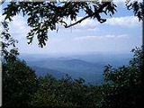
Geography
The mountain's peak is at 3780 feet (1,152.1 m) above mean sea level.Appalachian Trail
In 1958, the southern terminus of the Appalachian Trail was moved from Mount OglethorpeMount Oglethorpe
Mount Oglethorpe, the southernmost peak in the Blue Ridge Mountains, is located in Pickens County, Georgia and was the southern terminus of the Appalachian Trail from when the trail was completed in 1937 until 1958. In 1958, as a result of over development around Mount Oglethorpe, the southern...
approximately 14 miles (22.5 km) to the northeast to Springer Mountain because of increased development around Mount Oglethorpe. The most popular approach trail to Springer Mountain starts at the visitor's center of Amicalola Falls State Park
Amicalola Falls State Park
Amicalola Falls State Park is an 829 acre Georgia state park located between Ellijay and Dahlonega in Dawsonville, Georgia. The park's name is derived from a Cherokee language word meaning "tumbling waters". The park is home to Amicalola Falls, a 729-foot waterfall, making it the highest in...
and is 8.3 miles (13.4 km) in length. There is also another .9 mile trail leading from a parking lot on a forest service road to the starting point. At the peak of Springer Mountain is a bronze plaque with the Appalachian Trail logo, a register for hikers to sign, and a benchmark. An open-front trail shelter is provided for hikers.
Shelters
Springer Mountain Shelter is located at coordinates (84.19293W, 34.62883) on a spur trail leading about 70 yards (64 m) east of the Appalachian Trail. Blue blazes mark the spur trail. The trail junction (84.19376W, 34.62880N)is about 800 feet (240 m) north of the brass plaque marking the southern terminus of the Appalachian Trail. The shelter has a raised first floor and a sleeping loft reached by a permanent ladder. Each level of the shelter can comfortably sleep four or five backpackers.There is a fire circle and wooden picnic table in front (west) of the shelter. There is a three-walled privy down the hill directly behind the shelter. There is a piped spring about 30 yards (25 m) south of shelter. The spring has provided water even in recent drought years. There are two sturdy cables strung in trees near the shelter. Each is equipped with pulleys and hoisting lines for hauling backpacks and food bags out of reach of the local bears, raccoons and rodents.
There is a meadow with room for many tents near the intersection of the Appalachian Trail and the spur trail to the shelter. The meadow also has a fire circle.
The southern terminus of the Benton MacKaye Trail
Benton MacKaye Trail
The Benton MacKaye Trail or BMT is a footpath nearly in length in the Appalachian Mountains in the southeastern United States and is blazed by a white diamond, 5" across by 7" tall...
(84.19362W, 34.62963N) is about one hundred yards north of the shelter's spur trail's junction. A bronze plaque honors Benton MacKaye
Benton MacKaye
Benton MacKaye was an American forester, planner and conservationist. He was born in Stamford, Connecticut; his father was actor and dramatist Steele MacKaye. After studying forestry at Harvard University , Benton later taught there for several years. He joined a number of Federal bureaus and...
. The plaque is on a rock by the Benton MacKaye Trail a few yards east of the Appalachian Trail.