

Cloudland Canyon State Park
Encyclopedia
Cloudland Canyon State Park is a 3,485 acre (14.10 km²) Georgia
state park
located near Trenton
and Cooper Heights on the western edge of Lookout Mountain
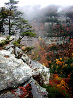
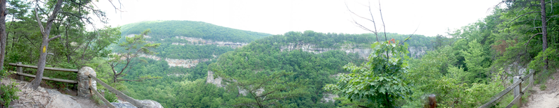
. One of the largest and most scenic parks in Georgia, it contains rugged geology
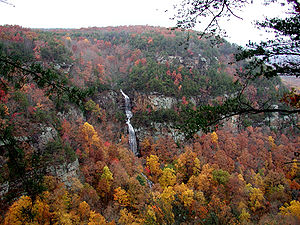
, and offers visitors a range of vistas across the deep gorge cut through the mountain by Sitton Gulch Creek, where the elevation varies from 800 to over 1,800 feet. Views of the canyon can be seen from the picnic area parking lot
, in addition to additional views located along the rim trail. At the bottom of the gorge two waterfalls cascade across layers of sandstone
and shale
, ending in small pools below.
The park, previously known as Sitton Gulch, was purchased in stages by the state of Georgia beginning in 1938. A project of Civilian Conservation Corps
built the first facilities and signs in the park, which opened the following year. Today the park features a variety of campsites, cabins, hiking and recreational activities.
 Cloudland Canyon was designated a state park in 1939 when the state began acquiring land from private owners. Three of these owners, from the Mathews, McCauley and McKaig families, still reside in the area. Expansion of the park continues sporadically as new land becomes available. The park was originally 1924 acres (7.8 km²), and has been expanded to its present size of 3485 acres (14.1 km²).
Until 1939 the only access to the area was through Tennessee or Alabama, however that year Georgia began work on Highway 136 to connect U.S. 41 to the recently created park. The Civilian Conservation Corps did much of the early work to construct the state park and access roads.
, atop Lookout Mountain
. On the summit of Lookout Mountain the waters of Daniel Creek and Bear Creek cut gorges through the rock, converging to form Sitton Gulch Creek. The flat-topped mountains of the Cumberland Plateau are significantly different from the narrow Armuchee ridges beyond nearby Chickamauga Valley to the east. From a geological standpoint Lookout Mountain is transitional between the flat-lying sedimentary beds of central Tennessee, and the ridges and valley lying to the east, which display more intensive folding and faulting. Most of the canyon's rock formations consist of sandstone; shale layers below the sandstone are marked by pine trees.
Lookout Mountain was created through a combination of seismic activity and erosion. It was uplifted during the period of mountain building that formed the Appalachians, known as the Appalachian orogeny
. Over 200 million years ago the modern-day park lay beneath an ocean. When first formed, the entire mountain was therefore underwater, but the rim of the canyon eventually became a beach along the edge of the receding ocean. As the ocean dried up, Sitton Gulch Creek and its tributaries, particularly Daniel Creek, eroded the rock. The sandstone forming the bluff
s has a tendency to fracture into blocks, creating unusual boulder formations. The concave shape of the top of Lookout Mountain also drains rainwater through fissures into the underlying limestone
, forming miles of subterranean caves in the area.
The canyon is more than 1000 feet (304.8 m) deep, ranging in elevation from 800 feet (243.8 m) to over 1800 feet (548.6 m); the park's peak elevation is 1980 feet (603.5 m). The bottom of Cloudland canyon contains a slope of rock talus
, which are sandstone and shale fragments. The valley floor is also rich in fossil-bearing limestone.
 The Park contains several well-marked trails which allow visitors to view the geology of the canyon and its surroundings, which spans millions of years.
A paved, wheelchair-accessible trail about 0.25 mile (0.402335 km) long overlooks the rim of the canyon. The park also features four more extensive hiking trails, including one backpacking trail. These trails are generally considered moderate in difficulty.
The Waterfalls Trail begins on a paved section, at the main overlook, and progresses into the canyon along a 40-degree slope. Most of the trail consists of gravel, and a 600-step staircase. Each waterfall emanates from Daniel Creek, and both cascade down sheer faces at 60 feet (18.3 m) and 90 feet (27.4 m). The trail is generally considered to be a strenuous hike, which can take up to 90 minutes to complete. The first waterfall
is 0.3 mile (0.482802 km) from the trailhead; the second waterfall
, at the bottom of the canyon, appears at 0.5 mile (0.80467 km). Each cascades into small pools at the base of the canyon, and continue down through a boulder-strewn stream bed. The creek flow feeding the waterfalls varies considerably according to the season.
In contrast, the 4.8 miles (7.7 km) long West Rim Loop Trail is rated as moderately difficult, although it contains a few short, steep rocky sections. A a scenic hike beginning at the Daniels Creek Bridge, it offers panoramic views, before climbing out of the canyon and onto the plateau. This trail also provides views of Trenton, Georgia, neighboring Sand Mountain, and of Cloudland Canyon itself. Rhododendron and mountain laurel thickets interspersed with sourgum, dogwood and large oaks, hickories, hemlocks and maples shade the trail. Cottages, West Rim, and Walk-In Camping areas are accessible via the West Rim Loop. Passing over varied terrain, most of the hike is moderately difficult, and is considered strenuous along several short sections.
The 2 miles (3.2 km) Backcountry Loop Trail provides access to the park's eleven secluded primitive hike-in camping sites. Beginning at the parking area for group camping, the trail passes through hemlock groves, before descending on a moderate grade into a hollow filled with spring and summer flowers. At the far end of the loop, hikers emerge from the hemlocks groves onto level trail, among oaks and hickories, before returning to the parking area.
In the fall of 2011, the park reopened the Bear Creek Trail that had been closed to hikers for nearly a decade. This approximately 9 miles (14.5 km) trail is the longest trail in Cloudland Canyon State Park. This trail begins as a spur off of the Back Country Trail and drops down to Bear Creek. After crossing the creek, the trail continues up until it becomes a loop around the northeast portion of the park. Around the area of the creek, the trail crosses over private property for a brief distance. During wet seasons the creek crossing can be difficult as there is no bridge or dry crossing available.
Picnic areas include a group pavilion, tennis courts, a children’s playground and a disc golf
course. The park has an interpretive center near the main parking lot, adjacent to the canyon. Annual events hosted in the park include a Wildflower Program in April, Adventure Weekend (also in April), and a Kids' Catfish Rodeo in May.
Georgia (U.S. state)
Georgia is a state located in the southeastern United States. It was established in 1732, the last of the original Thirteen Colonies. The state is named after King George II of Great Britain. Georgia was the fourth state to ratify the United States Constitution, on January 2, 1788...
state park
State park
State parks are parks or other protected areas managed at the federated state level within those nations which use "state" as a political subdivision. State parks are typically established by a state to preserve a location on account of its natural beauty, historic interest, or recreational...
located near Trenton
Trenton, Georgia
Trenton is a city in Dade County, Georgia, United States. The population was 1,942 at the 2000 census. It is the only incorporated municipality in the county, and as such it serves as the county seat....
and Cooper Heights on the western edge of Lookout Mountain
Lookout Mountain
thumb|right|See seven statesLookout Mountain is located at the northwest corner of the U.S. state of Georgia, the northeast corner of Alabama, and along the southern border of Tennessee at Chattanooga. Lookout Mountain, along with Sand Mountain to the northwest, makes up a large portion of the...
. One of the largest and most scenic parks in Georgia, it contains rugged geology
Geology
Geology is the science comprising the study of solid Earth, the rocks of which it is composed, and the processes by which it evolves. Geology gives insight into the history of the Earth, as it provides the primary evidence for plate tectonics, the evolutionary history of life, and past climates...
, and offers visitors a range of vistas across the deep gorge cut through the mountain by Sitton Gulch Creek, where the elevation varies from 800 to over 1,800 feet. Views of the canyon can be seen from the picnic area parking lot
Parking lot
A parking lot , also known as car lot, is a cleared area that is intended for parking vehicles. Usually, the term refers to a dedicated area that has been provided with a durable or semi-durable surface....
, in addition to additional views located along the rim trail. At the bottom of the gorge two waterfalls cascade across layers of sandstone
Sandstone
Sandstone is a sedimentary rock composed mainly of sand-sized minerals or rock grains.Most sandstone is composed of quartz and/or feldspar because these are the most common minerals in the Earth's crust. Like sand, sandstone may be any colour, but the most common colours are tan, brown, yellow,...
and shale
Shale
Shale is a fine-grained, clastic sedimentary rock composed of mud that is a mix of flakes of clay minerals and tiny fragments of other minerals, especially quartz and calcite. The ratio of clay to other minerals is variable. Shale is characterized by breaks along thin laminae or parallel layering...
, ending in small pools below.
The park, previously known as Sitton Gulch, was purchased in stages by the state of Georgia beginning in 1938. A project of Civilian Conservation Corps
Civilian Conservation Corps
The Civilian Conservation Corps was a public work relief program that operated from 1933 to 1942 in the United States for unemployed, unmarried men from relief families, ages 18–25. A part of the New Deal of President Franklin D...
built the first facilities and signs in the park, which opened the following year. Today the park features a variety of campsites, cabins, hiking and recreational activities.
History
Until 1939 the only access to the area was through Tennessee or Alabama, however that year Georgia began work on Highway 136 to connect U.S. 41 to the recently created park. The Civilian Conservation Corps did much of the early work to construct the state park and access roads.
Geology
The park is located on the Cumberland PlateauCumberland Plateau
The Cumberland Plateau is the southern part of the Appalachian Plateau. It includes much of eastern Kentucky and western West Virginia, part of Tennessee, and a small portion of northern Alabama and northwest Georgia . The terms "Allegheny Plateau" and the "Cumberland Plateau" both refer to the...
, atop Lookout Mountain
Lookout Mountain
thumb|right|See seven statesLookout Mountain is located at the northwest corner of the U.S. state of Georgia, the northeast corner of Alabama, and along the southern border of Tennessee at Chattanooga. Lookout Mountain, along with Sand Mountain to the northwest, makes up a large portion of the...
. On the summit of Lookout Mountain the waters of Daniel Creek and Bear Creek cut gorges through the rock, converging to form Sitton Gulch Creek. The flat-topped mountains of the Cumberland Plateau are significantly different from the narrow Armuchee ridges beyond nearby Chickamauga Valley to the east. From a geological standpoint Lookout Mountain is transitional between the flat-lying sedimentary beds of central Tennessee, and the ridges and valley lying to the east, which display more intensive folding and faulting. Most of the canyon's rock formations consist of sandstone; shale layers below the sandstone are marked by pine trees.
Lookout Mountain was created through a combination of seismic activity and erosion. It was uplifted during the period of mountain building that formed the Appalachians, known as the Appalachian orogeny
Alleghenian orogeny
The Alleghenian orogeny or Appalachian orogeny is one of the geological mountain-forming events that formed the Appalachian Mountains and Allegheny Mountains. The term and spelling Alleghany orogeny was originally proposed by H.P. Woodward in 1957....
. Over 200 million years ago the modern-day park lay beneath an ocean. When first formed, the entire mountain was therefore underwater, but the rim of the canyon eventually became a beach along the edge of the receding ocean. As the ocean dried up, Sitton Gulch Creek and its tributaries, particularly Daniel Creek, eroded the rock. The sandstone forming the bluff
Cliff
In geography and geology, a cliff is a significant vertical, or near vertical, rock exposure. Cliffs are formed as erosion landforms due to the processes of erosion and weathering that produce them. Cliffs are common on coasts, in mountainous areas, escarpments and along rivers. Cliffs are usually...
s has a tendency to fracture into blocks, creating unusual boulder formations. The concave shape of the top of Lookout Mountain also drains rainwater through fissures into the underlying limestone
Limestone
Limestone is a sedimentary rock composed largely of the minerals calcite and aragonite, which are different crystal forms of calcium carbonate . Many limestones are composed from skeletal fragments of marine organisms such as coral or foraminifera....
, forming miles of subterranean caves in the area.
The canyon is more than 1000 feet (304.8 m) deep, ranging in elevation from 800 feet (243.8 m) to over 1800 feet (548.6 m); the park's peak elevation is 1980 feet (603.5 m). The bottom of Cloudland canyon contains a slope of rock talus
Scree
Scree, also called talus, is a term given to an accumulation of broken rock fragments at the base of crags, mountain cliffs, or valley shoulders. Landforms associated with these materials are sometimes called scree slopes or talus piles...
, which are sandstone and shale fragments. The valley floor is also rich in fossil-bearing limestone.
Hiking trails
A paved, wheelchair-accessible trail about 0.25 mile (0.402335 km) long overlooks the rim of the canyon. The park also features four more extensive hiking trails, including one backpacking trail. These trails are generally considered moderate in difficulty.
The Waterfalls Trail begins on a paved section, at the main overlook, and progresses into the canyon along a 40-degree slope. Most of the trail consists of gravel, and a 600-step staircase. Each waterfall emanates from Daniel Creek, and both cascade down sheer faces at 60 feet (18.3 m) and 90 feet (27.4 m). The trail is generally considered to be a strenuous hike, which can take up to 90 minutes to complete. The first waterfall
Cloudland Canyon Falls 1
Cloudland Canyon Falls #1 is an unnamed waterfall located in Cloudland Canyon State Park in Dade County, Georgia....
is 0.3 mile (0.482802 km) from the trailhead; the second waterfall
Cloudland Canyon Falls 2
Cloudland Canyon Falls #2 is an unnamed waterfall located in Cloudland Canyon State Park in Dade County, Georgia....
, at the bottom of the canyon, appears at 0.5 mile (0.80467 km). Each cascades into small pools at the base of the canyon, and continue down through a boulder-strewn stream bed. The creek flow feeding the waterfalls varies considerably according to the season.
In contrast, the 4.8 miles (7.7 km) long West Rim Loop Trail is rated as moderately difficult, although it contains a few short, steep rocky sections. A a scenic hike beginning at the Daniels Creek Bridge, it offers panoramic views, before climbing out of the canyon and onto the plateau. This trail also provides views of Trenton, Georgia, neighboring Sand Mountain, and of Cloudland Canyon itself. Rhododendron and mountain laurel thickets interspersed with sourgum, dogwood and large oaks, hickories, hemlocks and maples shade the trail. Cottages, West Rim, and Walk-In Camping areas are accessible via the West Rim Loop. Passing over varied terrain, most of the hike is moderately difficult, and is considered strenuous along several short sections.
The 2 miles (3.2 km) Backcountry Loop Trail provides access to the park's eleven secluded primitive hike-in camping sites. Beginning at the parking area for group camping, the trail passes through hemlock groves, before descending on a moderate grade into a hollow filled with spring and summer flowers. At the far end of the loop, hikers emerge from the hemlocks groves onto level trail, among oaks and hickories, before returning to the parking area.
In the fall of 2011, the park reopened the Bear Creek Trail that had been closed to hikers for nearly a decade. This approximately 9 miles (14.5 km) trail is the longest trail in Cloudland Canyon State Park. This trail begins as a spur off of the Back Country Trail and drops down to Bear Creek. After crossing the creek, the trail continues up until it becomes a loop around the northeast portion of the park. Around the area of the creek, the trail crosses over private property for a brief distance. During wet seasons the creek crossing can be difficult as there is no bridge or dry crossing available.
Facilities and activities
Cloudland Canyon State park features a variety of camping and lodging options. There are 16 rental cottages as well as a group lodge, and the park also offers 73 tent, trailer and RV sites, 30 walk-in camp sites, and 11 back country camp sites for backpackers. Four pioneer sites provide facilities for groups of tent campers. The East Rim has 24 camp sites located along a loop road; many of the sites can accommodate RVs, and all feature water and electric hookups. Bathing facilities are located nearby. The West Rim Camp ground, located across the gorge and away from the park's busiest section, is located in thick forest, and hosts approximately 48 camp sites spread along two loops. It too offers bathing facilities.Picnic areas include a group pavilion, tennis courts, a children’s playground and a disc golf
Disc golf
Disc golf is a disc game in which individual players throw a flying disc into a basket or at a target. According to the Professional Disc Golf Association, "The object of the game is to traverse a course from beginning to end in the fewest number of throws of the disc." Of the more than 3000...
course. The park has an interpretive center near the main parking lot, adjacent to the canyon. Annual events hosted in the park include a Wildflower Program in April, Adventure Weekend (also in April), and a Kids' Catfish Rodeo in May.