

Virginia Peninsula
Encyclopedia
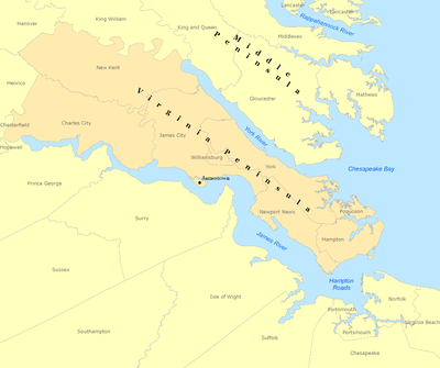
The Virginia Peninsula is a peninsula
Peninsula
A peninsula is a piece of land that is bordered by water on three sides but connected to mainland. In many Germanic and Celtic languages and also in Baltic, Slavic and Hungarian, peninsulas are called "half-islands"....
in southeast Virginia
Virginia
The Commonwealth of Virginia , is a U.S. state on the Atlantic Coast of the Southern United States. Virginia is nicknamed the "Old Dominion" and sometimes the "Mother of Presidents" after the eight U.S. presidents born there...
, USA, bounded by the York River
York River (Virginia)
The York River is a navigable estuary, approximately long, in eastern Virginia in the United States. It ranges in width from at its head to near its mouth on the west side of Chesapeake Bay. Its watershed drains an area including portions of 17 counties of the coastal plain of Virginia north...
, James River
James River (Virginia)
The James River is a river in the U.S. state of Virginia. It is long, extending to if one includes the Jackson River, the longer of its two source tributaries. The James River drains a catchment comprising . The watershed includes about 4% open water and an area with a population of 2.5 million...
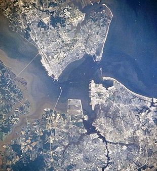
, Hampton Roads
Hampton Roads
Hampton Roads is the name for both a body of water and the Norfolk–Virginia Beach metropolitan area which surrounds it in southeastern Virginia, United States...
and Chesapeake Bay
Chesapeake Bay
The Chesapeake Bay is the largest estuary in the United States. It lies off the Atlantic Ocean, surrounded by Maryland and Virginia. The Chesapeake Bay's drainage basin covers in the District of Columbia and parts of six states: New York, Pennsylvania, Delaware, Maryland, Virginia, and West...
.
Hampton Roads
Hampton Roads
Hampton Roads is the name for both a body of water and the Norfolk–Virginia Beach metropolitan area which surrounds it in southeastern Virginia, United States...
is the common name for the metropolitan area that surrounds the body of water of the same name. The land portion of Hampton Roads has been historically divided into two regions, the Virginia Peninsula or Peninsula on the north side, and South Hampton Roads
South Hampton Roads
South Hampton Roads is a region located in the extreme southeastern portion of Virginia in the United States, and is part of the Virginia Beach-Norfolk-Newport News, VA-NC MSA with a population about 1.7 million....
on the south side. (Locally, South Hampton Roads is commonly called "the Southside", which is not to be confused with "Southside Virginia", which is a separate region of the south central portion of Virginia located farther inland.) More recently, the metropolitan area has expanded to include the two southernmost counties of the Middle Peninsula
Middle Peninsula
The Middle Peninsula is the second of three large peninsulas on the western shore of Chesapeake Bay in Virginia, in the United States. It lies between the Northern Neck and the Virginia Peninsula. This peninsula is bounded by the Rappahannock River on the north and the York River on the south...
, across the York River
York River (Virginia)
The York River is a navigable estuary, approximately long, in eastern Virginia in the United States. It ranges in width from at its head to near its mouth on the west side of Chesapeake Bay. Its watershed drains an area including portions of 17 counties of the coastal plain of Virginia north...
from the Virginia Peninsula.
Geographically located at the northwestern reaches, Charles City
Charles City County, Virginia
As of the census of 2000, there were 6,926 people, 2,670 households, and 1,975 families residing in the county. The population density was 38 people per square mile . There were 2,895 housing units at an average density of 16 per square mile...
and New Kent
New Kent County, Virginia
At the 2000 census, there were 13,462 people, 4,925 households and 3,895 families residing in the county. The population density was 64 per square mile . There were 5,203 housing units at an average density of 25 per square mile...
counties are by some reckonings part of the Virginia Peninsula. However, in modern times, they are more often considered part of the Richmond-Petersburg
Richmond-Petersburg
The Greater Richmond Region is a region located in a central part of the state of Virginia in the United States. As of 2010, it had a population of 1,258,251, making it the 43rd largest MSA in the country...
region. The rest of the Virginia Peninsula is all part of the Virginia Beach-Norfolk-Newport News, VA-NC MSA (Metropolitan Statistical Area) with a population of about 1.6 million. The Hampton Roads MSA is the seventh largest metropolitan area in the southeastern United States and the largest between Washington, D.C., and Charlotte, North Carolina.
History
Jamestown, Virginia
Jamestown was a settlement in the Colony of Virginia. Established by the Virginia Company of London as "James Fort" on May 14, 1607 , it was the first permanent English settlement in what is now the United States, following several earlier failed attempts, including the Lost Colony of Roanoke...
. The first continuously occupied settlement was at Kecoughtan
Kecoughtan, Virginia
Kecoughtan in Virginia was originally named Kikotan , the name of the Algonquian Native Americans living there when the English colonists arrived in the Hampton Roads area in 1607....
in Elizabeth City County
Elizabeth City County, Virginia
Elizabeth City County was a county in southeastern Virginia from 1634 to 1952. Originally created in 1634 as Elizabeth River Shire, it was one of eight shires created in the Virginia Colony by order of the King of England. In 1636, it was subdivided, and the portion north of the harbor of Hampton...
what is now the City of Hampton
Hampton, Virginia
Hampton is an independent city that is not part of any county in Southeast Virginia. Its population is 137,436. As one of the seven major cities that compose the Hampton Roads metropolitan area, it is on the southeastern end of the Virginia Peninsula. Located on the Hampton Roads Beltway, it hosts...
. Nearby, Fort Monroe
Fort Monroe
Fort Monroe was a military installation in Hampton, Virginia—at Old Point Comfort, the southern tip of the Virginia Peninsula...
, the country's oldest military base still in use is located at Old Point Comfort
Old Point Comfort
Old Point Comfort is a point of land located in the independent city of Hampton. It lies at the extreme tip of the Virginia Peninsula at the mouth of Hampton Roads in the United States....
. After declaring independence from Great Britain, Virginia's first state capital was Williamsburg
Williamsburg, Virginia
Williamsburg is an independent city located on the Virginia Peninsula in the Hampton Roads metropolitan area of Virginia, USA. As of the 2010 Census, the city had an estimated population of 14,068. It is bordered by James City County and York County, and is an independent city...
. Also, the decisive battle of the American Revolution
American Revolution
The American Revolution was the political upheaval during the last half of the 18th century in which thirteen colonies in North America joined together to break free from the British Empire, combining to become the United States of America...
, the siege of Yorktown
Siege of Yorktown
The Siege of Yorktown, Battle of Yorktown, or Surrender of Yorktown in 1781 was a decisive victory by a combined assault of American forces led by General George Washington and French forces led by the Comte de Rochambeau over a British Army commanded by Lieutenant General Lord Cornwallis...
in 1781, took place on the Virginia Peninsula.
During the American Civil War
American Civil War
The American Civil War was a civil war fought in the United States of America. In response to the election of Abraham Lincoln as President of the United States, 11 southern slave states declared their secession from the United States and formed the Confederate States of America ; the other 25...
(1861–1865), the Union Army
Union Army
The Union Army was the land force that fought for the Union during the American Civil War. It was also known as the Federal Army, the U.S. Army, the Northern Army and the National Army...
invaded the Virginia Peninsula as part of the Peninsula Campaign
Peninsula Campaign
The Peninsula Campaign of the American Civil War was a major Union operation launched in southeastern Virginia from March through July 1862, the first large-scale offensive in the Eastern Theater. The operation, commanded by Maj. Gen. George B...
in 1862 to capture Richmond
Richmond, Virginia
Richmond is the capital of the Commonwealth of Virginia, in the United States. It is an independent city and not part of any county. Richmond is the center of the Richmond Metropolitan Statistical Area and the Greater Richmond area...
, beginning from Fort Monroe
Fort Monroe
Fort Monroe was a military installation in Hampton, Virginia—at Old Point Comfort, the southern tip of the Virginia Peninsula...
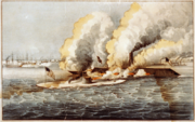
at the entrance to Hampton Roads, which had remained in Union control after Virginia seceded in 1861. At the outset of the Peninsula Campaign, the Battle of Hampton Roads
Battle of Hampton Roads
The Battle of Hampton Roads, often referred to as either the Battle of the Monitor and Merrimack or the Battle of Ironclads, was the most noted and arguably most important naval battle of the American Civil War from the standpoint of the development of navies...
between the first ironclad warship
Ironclad warship
An ironclad was a steam-propelled warship in the early part of the second half of the 19th century, protected by iron or steel armor plates. The ironclad was developed as a result of the vulnerability of wooden warships to explosive or incendiary shells. The first ironclad battleship, La Gloire,...
s took place near the mouth of the James River off the eastern tip of Warwick County
Warwick County, Virginia
Warwick County was a county in Southeast Virginia that was created from Warwick River Shire, one of eight created in the Virginia Colony in 1634. It became the City of Warwick on July 16, 1952...
. The 1862 Siege of Yorktown
Battle of Yorktown (1862)
The Battle of Yorktown or Siege of Yorktown was fought from April 5 to May 4, 1862, as part of the Peninsula Campaign of the American Civil War. Marching from Fort Monroe, Union Maj. Gen. George B. McClellan's Army of the Potomac encountered Maj. Gen. John B. Magruder's small Confederate force...
took place along the York River. Finally, after a lengthy standoff, the largest Union Army of the war under General George B. McClellan
George B. McClellan
George Brinton McClellan was a major general during the American Civil War. He organized the famous Army of the Potomac and served briefly as the general-in-chief of the Union Army. Early in the war, McClellan played an important role in raising a well-trained and organized army for the Union...
chased the retreating Confederates through the Williamsburg Line and westward literally to the "Gates of Richmond", where the swampy upper reaches of the Chickahominy River created a natural barrier behind which the defenders successfully held the Confederate capital, essentially prolonging the War for 3 more devastating years.
As the region and Virginia rebuilt during Reconstruction, the Chesapeake and Ohio Railway
Chesapeake and Ohio Railway
The Chesapeake and Ohio Railway was a Class I railroad formed in 1869 in Virginia from several smaller Virginia railroads begun in the 19th century. Led by industrialist Collis P...
(C&O) under the leadership of Collis P. Huntington
Collis P. Huntington
Collis Potter Huntington was one of the Big Four of western railroading who built the Central Pacific Railroad as part of the first U.S. transcontinental railroad...
was completed from Richmond to the Ohio River
Ohio River
The Ohio River is the largest tributary, by volume, of the Mississippi River. At the confluence, the Ohio is even bigger than the Mississippi and, thus, is hydrologically the main stream of the whole river system, including the Allegheny River further upstream...
by 1871. Long a dream of Virginians, and later sponsored by both Virginia and West Virginia, the new railroad opened paths to ship products west, as well as offering an economically viable method of shipping the rich bituminous coal
Bituminous coal
Bituminous coal or black coal is a relatively soft coal containing a tarlike substance called bitumen. It is of higher quality than lignite coal but of poorer quality than Anthracite...
of the region to fuel the Industrial Revolution
Industrial Revolution
The Industrial Revolution was a period from the 18th to the 19th century where major changes in agriculture, manufacturing, mining, transportation, and technology had a profound effect on the social, economic and cultural conditions of the times...
. However, the tidal portion of the James River
James River (Virginia)
The James River is a river in the U.S. state of Virginia. It is long, extending to if one includes the Jackson River, the longer of its two source tributaries. The James River drains a catchment comprising . The watershed includes about 4% open water and an area with a population of 2.5 million...
, while navigable from Hampton Roads to the fall line
Fall line
A fall line is a geomorphologic unconformity between an upland region of relatively hard crystalline basement rock and a coastal plain of softer sedimentary rock. A fall line is typically prominent when crossed by a river, for there will often be rapids or waterfalls...
at Richmond, couldn't accommodate the deep drafts of ollier ships.
The Peninsula had been long without a railroad, which had been newly developing technology beginning in the 1830s. In 1881, the Peninsula Extension
Peninsula Extension
The Peninsula Extension which created the Peninsula Subdivision of the Chesapeake and Ohio Railway was the new railroad line on the Virginia Peninsula from Richmond to southeastern Warwick County...
of the C&O was built from Richmond through Williamsburg to Newport News Point. There, Collis Huntington, his associates, and his Old Dominion Land Company developed his vision for the area. Within only 15 years, a rural farm community in Warwick County turned into the new independent city of Newport News, Virginia
Newport News, Virginia
Newport News is an independent city located in the Hampton Roads metropolitan area of Virginia. It is at the southeastern end of the Virginia Peninsula, on the north shore of the James River extending southeast from Skiffe's Creek along many miles of waterfront to the river's mouth at Newport News...
by 1896 as new coal pier
Coal pier
A coal pier is a transloading facility designed for the transfer of coal between rail and ship.The typical facility for loading ships consists of a holding area and a system of conveyors for transferring the coal to dockside and loading it into the ship's cargo holds...
s brought ships to what would become the world's largest shipyard, Newport News Shipbuilding and Drydock Company. Hotels, houses, schools and businesses sprung up there, and at many points along the new rail line in Warwick, York and James City counties. Oyster Point became a shipping place for the watermen and the new town of Lee Hall, Virginia
Lee Hall, Virginia
Lee Hall is a former unincorporated town long located in the former Warwick County. Since 1958, Lee Hall has been a suburban community in the extreme western portion of the independent city of Newport News in the Commonwealth of Virginia....
emerged, and became an important point due to its proximity to Yorktown and later to the new military base which became the U.S. Army's Fort Eustis. In Elizabeth City County
Elizabeth City County, Virginia
Elizabeth City County was a county in southeastern Virginia from 1634 to 1952. Originally created in 1634 as Elizabeth River Shire, it was one of eight shires created in the Virginia Colony by order of the King of England. In 1636, it was subdivided, and the portion north of the harbor of Hampton...
, tracks were extended from Newport News to reach Old Point Comfort
Old Point Comfort
Old Point Comfort is a point of land located in the independent city of Hampton. It lies at the extreme tip of the Virginia Peninsula at the mouth of Hampton Roads in the United States....
, where resort hotels and Buckroe Beach were developed. There, a new town was incorporated. Phoebus
Phoebus, Virginia
Phoebus was an incorporated town located in Elizabeth City County on the Virginia Peninsula in eastern Virginia. Upon incorporation in 1900, it was named in honor of local businessman Harrison Phoebus , who is credited with convincing the Chesapeake and Ohio Railway to extend its tracks to the...
was named after one of its early leading citizens, Harrison Phoebus
Harrison Phoebus
Harrison Phoebus was an American 19th century entrepreneur and hotelier who became the leading citizen and namesake of the town of Phoebus in Elizabeth City County, near Fort Monroe, which is now part of the independent city of Hampton, Virginia....
. In James City County, Toano
Toano, Virginia
Toano is an unincorporated town in James City County, Virginia, United States.-History:Toano was established in the late 19th century in western James City County at the former site of Burnt Ordinary, which was named in the 18th century for a roadside tavern that had burned down...
became a major shipping point for the area's truck farming and an entire new development planned by a C&O land agent to attract farmers of Scandinavian descent from the colder regions of the American Mid-West emerged at Norge
Norge, Virginia
Norge is an unincorporated community in James City County, Virginia, United States.-Location:Norge was located on the old Richmond-Williamsburg Stage Road, which is U.S. Route 60 in modern times. Interstate 64 was built through the area in the 1970s, and passes nearby...
shortly after the turn of the century.
Later in the first half of the 20th century, especially during the two world wars, massive military facilities were established on large reservations which today contain Langley Air Force Base, Fort Eustis, Naval Weapons Station Yorktown
Naval Weapons Station Yorktown
Naval Weapons Station Yorktown is a United States Navy base in York County, James City County, and Newport News in the Hampton Roads region of Virginia...
, and Camp Peary
Camp Peary
Camp Peary is a military reservation in York County near Williamsburg, Virginia. Officially it is referred to as the Armed Forces Experimental Training Activity under the auspices of the Department of Defense, but it is widely believed to be the location of a covert CIA training facility known...
. To make way, all of Mulberry Island
Mulberry Island
Mulberry Island is located along the James River in the city of Newport News, Virginia, in southeastern Virginia at the confluence of the Warwick River on the Virginia Peninsula.- History:...
and entire communities including the lost towns of Lackey
Lackey, Virginia
Lackey was a small unincorporated community near Yorktown in York County, Virginia, United States...
, Halstead's Point
Halstead's Point, Virginia
Halstead's Point was an unincorporated community in York County, Virginia. In 1918, during World War I, a large tract of land in the area including Halstead's Point was taken by the U.S. Navy to create a military base initially known as a mine depot, where ordnance for military shifts was handled...
, Penniman
Penniman, Virginia
Penniman was an unincorporated town in northwestern York County, on the south bank of the York River six miles northeast of Williamsburg in the Virginia Peninsula area of the Hampton Roads region of southeastern Virginia in the United States...
, Bigler's Mill
Bigler's Mill, Virginia
Bigler's Mill was a small town in Virginia near Williamsburg in York County which is now extinct. It is now considered one of the many lost towns of Virginia....
, and Magruder
Magruder, Virginia
Magruder was a small unincorporated town in Virginia near Williamsburg in York County. Now extinct, it once had its own church, post office, cemetery, lodge, and homes. Magruder is considered one of the many lost towns of Virginia. The land on which it stood is now part of the US military...
disappeared in the process. However, many of the displaced Virginians chose to relocate to Grove
Grove, Virginia
Grove is an unincorporated community in the southeastern portion of James City County in the Peninsula subregion of Virginia in the United States. It is located in the center of the Historic Triangle of Colonial Virginia, communities linked by the Colonial Parkway; the area is one of the busiest...
in James City County and other areas close by on the Peninsula.
After the capital of Virginia moved to Richmond in 1780 for greater security during the American Revolutionary War, Williamsburg became much less busy. By the early 20th century, it was described as a "sleepy little hamlet", known best for the College of William and Mary
College of William and Mary
The College of William & Mary in Virginia is a public research university located in Williamsburg, Virginia, United States...
and Eastern State Hospital, which was the successor to the country's first mental hospital, as well as its fading memories and deteriorating colonial sites. All that changed dramatically beginning in 1926. The restoration and recreation of Colonial Williamsburg
Colonial Williamsburg
Colonial Williamsburg is the private foundation representing the historic district of the city of Williamsburg, Virginia, USA. The district includes buildings dating from 1699 to 1780 which made colonial Virginia's capital. The capital straddled the boundary of the original shires of Virginia —...
, one of the largest historic restorations ever undertaken, was championed by the Reverend Dr. W.A.R. Goodwin and the patriarch of the Rockefeller family
Rockefeller family
The Rockefeller family , the Cleveland family of John D. Rockefeller and his brother William Rockefeller , is an American industrial, banking, and political family of German origin that made one of the world's largest private fortunes in the oil business during the late 19th and early 20th...
, John D. Rockefeller, Jr.
John D. Rockefeller, Jr.
John Davison Rockefeller, Jr. was a major philanthropist and a pivotal member of the prominent Rockefeller family. He was the sole son among the five children of businessman and Standard Oil industrialist John D. Rockefeller and the father of the five famous Rockefeller brothers...
, along with the active participation of his wife, Abby Aldrich Rockefeller
Abby Aldrich Rockefeller
Abby Aldrich Rockefeller, , was a prominent socialite and philanthropist and the second-generation matriarch of the renowned Rockefeller family...
, who wanted to celebrate the patriots and the early history of the United States
History of the United States
The history of the United States traditionally starts with the Declaration of Independence in the year 1776, although its territory was inhabited by Native Americans since prehistoric times and then by European colonists who followed the voyages of Christopher Columbus starting in 1492. The...
. The restoration of the colonial capital, construction of the Colonial Parkway
Colonial Parkway
Colonial Parkway is a scenic 23-mile parkway linking the three popular attractions of Virginia's Historic Triangle of colonial-era communities, Jamestown, Williamsburg, and Yorktown...
by the U.S. National Park Service, several major enhancements at Jamestown and Yorktown, and development of several theme parks such as Busch Gardens Europe
Busch Gardens Europe
Busch Gardens Williamsburg is a 383 acre theme park located in James City County, Virginia about 3 miles southeast of Williamsburg, originally developed by Anheuser-Busch and currently owned by SeaWorld Parks & Entertainment, a division of The Blackstone Group...
beginning in the 1970s, all combined to help make the Historic Triangle
Historic Triangle
The Historic Triangle is located on the Virginia Peninsula of the United States and includes the colonial communities of Jamestown, Colonial Williamsburg, and Yorktown, with many restored attractions linked by the Colonial Parkway in James City and York counties and the City of...
area of Colonial Virginia become one of the most popular tourist destinations in the United States by the end of the 20th century.
Local government
In Colonial times, and even in the first 150 years of the United States, much like Virginia as a whole, the Virginia Peninsula was in an almost constant state of change in terms of local government, largely due to growth, as counties were divided and towns were formed as the population grew. Some towns grew to become cities. Under the state constitutional changes in 1871, extant and future cities in Virginia became independent citiesIndependent city
An independent city is a city that does not form part of another general-purpose local government entity. These type of cities should not be confused with city-states , which are fully sovereign cities that are not part of any other sovereign state.-Historical precursors:In the Holy Roman Empire,...
of the counties they had formerly been located within.
However, in the second half of the 20th century, an unprecedented wave of city-county-town local government consolidations took place in South Hampton Roads and on the Virginia Peninsula. Nowhere else in Virginia have rural areas and more dense cities been combined in such a manner as these two areas. The changes resulted in the two areas having Virginia's cities with the largest land areas and the most farming, even over 30 years after the consolidations in some instances.
Current political subdivisions
The Virginia Peninsula subregion includes four independent citiesIndependent city
An independent city is a city that does not form part of another general-purpose local government entity. These type of cities should not be confused with city-states , which are fully sovereign cities that are not part of any other sovereign state.-Historical precursors:In the Holy Roman Empire,...
(Hampton
Hampton, Virginia
Hampton is an independent city that is not part of any county in Southeast Virginia. Its population is 137,436. As one of the seven major cities that compose the Hampton Roads metropolitan area, it is on the southeastern end of the Virginia Peninsula. Located on the Hampton Roads Beltway, it hosts...
, Newport News
Newport News, Virginia
Newport News is an independent city located in the Hampton Roads metropolitan area of Virginia. It is at the southeastern end of the Virginia Peninsula, on the north shore of the James River extending southeast from Skiffe's Creek along many miles of waterfront to the river's mouth at Newport News...
, Poquoson
Poquoson, Virginia
Poquoson is an independent city located on the Virginia Peninsula, in the Hampton Roads metropolitan area of the U.S. state of Virginia. The population was 12,150 according to the 2010 Census...
and Williamsburg
Williamsburg, Virginia
Williamsburg is an independent city located on the Virginia Peninsula in the Hampton Roads metropolitan area of Virginia, USA. As of the 2010 Census, the city had an estimated population of 14,068. It is bordered by James City County and York County, and is an independent city...
) and two counties (James City County
James City County, Virginia
James City County is a county located on the Virginia Peninsula in the Hampton Roads metropolitan area of the Commonwealth of Virginia, a state of the United States. Its population was 67,009 , and it is often associated with Williamsburg, an independent city, and Jamestown which is within the...
and York County
York County, Virginia
York County is a county located on the north side of the Virginia Peninsula in the Hampton Roads metropolitan area of the Commonwealth of Virginia, a state of the United States. Situated on the York River and many tributaries, the county seat is the unincorporated town of Yorktown...
). There are currently no incorporated towns. There were also a number of political subdivisions which are now extinct, primarily due to both growth of communities and consolidation of local government (see section below).
| Name | Capital | Area (km²) | Population 2000 Census | Population 2010 Census |
|---|---|---|---|---|
| Hampton Hampton, Virginia Hampton is an independent city that is not part of any county in Southeast Virginia. Its population is 137,436. As one of the seven major cities that compose the Hampton Roads metropolitan area, it is on the southeastern end of the Virginia Peninsula. Located on the Hampton Roads Beltway, it hosts... |
Hampton Hampton, Virginia Hampton is an independent city that is not part of any county in Southeast Virginia. Its population is 137,436. As one of the seven major cities that compose the Hampton Roads metropolitan area, it is on the southeastern end of the Virginia Peninsula. Located on the Hampton Roads Beltway, it hosts... |
|||
| Newport News Newport News, Virginia Newport News is an independent city located in the Hampton Roads metropolitan area of Virginia. It is at the southeastern end of the Virginia Peninsula, on the north shore of the James River extending southeast from Skiffe's Creek along many miles of waterfront to the river's mouth at Newport News... |
Newport News Newport News, Virginia Newport News is an independent city located in the Hampton Roads metropolitan area of Virginia. It is at the southeastern end of the Virginia Peninsula, on the north shore of the James River extending southeast from Skiffe's Creek along many miles of waterfront to the river's mouth at Newport News... |
|||
| Poquoson Poquoson, Virginia Poquoson is an independent city located on the Virginia Peninsula, in the Hampton Roads metropolitan area of the U.S. state of Virginia. The population was 12,150 according to the 2010 Census... |
Poquoson Poquoson, Virginia Poquoson is an independent city located on the Virginia Peninsula, in the Hampton Roads metropolitan area of the U.S. state of Virginia. The population was 12,150 according to the 2010 Census... |
|||
| Williamsburg Williamsburg, Virginia Williamsburg is an independent city located on the Virginia Peninsula in the Hampton Roads metropolitan area of Virginia, USA. As of the 2010 Census, the city had an estimated population of 14,068. It is bordered by James City County and York County, and is an independent city... |
Williamsburg Williamsburg, Virginia Williamsburg is an independent city located on the Virginia Peninsula in the Hampton Roads metropolitan area of Virginia, USA. As of the 2010 Census, the city had an estimated population of 14,068. It is bordered by James City County and York County, and is an independent city... |
|||
| James City County James City County, Virginia James City County is a county located on the Virginia Peninsula in the Hampton Roads metropolitan area of the Commonwealth of Virginia, a state of the United States. Its population was 67,009 , and it is often associated with Williamsburg, an independent city, and Jamestown which is within the... |
Williamsburg Williamsburg, Virginia Williamsburg is an independent city located on the Virginia Peninsula in the Hampton Roads metropolitan area of Virginia, USA. As of the 2010 Census, the city had an estimated population of 14,068. It is bordered by James City County and York County, and is an independent city... |
|||
| York County York County, Virginia York County is a county located on the north side of the Virginia Peninsula in the Hampton Roads metropolitan area of the Commonwealth of Virginia, a state of the United States. Situated on the York River and many tributaries, the county seat is the unincorporated town of Yorktown... |
Yorktown Yorktown, Virginia Yorktown is a census-designated place in York County, Virginia, United States. The population was 220 in the 2000 census. It is the county seat of York County, one of the eight original shires formed in colonial Virginia in 1634.... |
|||
| Totals |
Defunct political subdivisions
Many incorporated (formally constituted) localities have become legally void, though most have not been abandoned by their citizens, with the notable exception of Jamestown. Exclusive of towns which became cities and still have the same name, no less than 4 shires, 2 counties, 4 towns, and 1 city no longer exist in the Virginia Peninsula area under their earlier names.The following is a listing of these 11 extinct shire, counties, towns, and cities, with the approximate dates they existed:
- Jamestown, VirginiaJamestown, VirginiaJamestown was a settlement in the Colony of Virginia. Established by the Virginia Company of London as "James Fort" on May 14, 1607 , it was the first permanent English settlement in what is now the United States, following several earlier failed attempts, including the Lost Colony of Roanoke...
(1607) largely abandoned as a Town after 1699 - Kecoughtan, VirginiaKecoughtan, VirginiaKecoughtan in Virginia was originally named Kikotan , the name of the Algonquian Native Americans living there when the English colonists arrived in the Hampton Roads area in 1607....
(1610), became part of Town and City of Hampton - Middle PlantationMiddle PlantationMiddle Plantation in the Virginia Colony, was the unincorporated town established in 1632 that became Williamsburg in 1699. It was located on high ground about half-way across the Virginia Peninsula between the James River and York River. Middle Plantation represented the first major inland...
(1632), became Williamsburg after 1699 - Elizabeth River Shire (1634–1643)
- Warwick River ShireWarwick River ShireWarwick River Shire was one of eight shires created in colonial Virginia in 1634. It was located on the Virginia Peninsula on the northern shore of the James River between Hampton Roads and the Jamestown Settlement....
(1634–1643) - Charles River ShireCharles River ShireCharles River Shire was one of eight shires of Virginia created in the Virginia Colony in 1634.During the 17th century, shortly after establishment of Jamestown, Virginia in 1607, English settlers and explored and began settling the areas adjacent to Hampton Roads...
(1634–1643) - James City ShireJames City ShireJames City Shire was formed in the British colony of Virginia in 1634.During the 17th century, shortly after establishment of Jamestown in 1607, English settlers and explored and began settling the areas adjacent to Hampton Roads....
(1634–1643) - Elizabeth City CountyElizabeth City County, VirginiaElizabeth City County was a county in southeastern Virginia from 1634 to 1952. Originally created in 1634 as Elizabeth River Shire, it was one of eight shires created in the Virginia Colony by order of the King of England. In 1636, it was subdivided, and the portion north of the harbor of Hampton...
(1643-1952), now part of the city of Hampton. - Warwick CountyWarwick County, VirginiaWarwick County was a county in Southeast Virginia that was created from Warwick River Shire, one of eight created in the Virginia Colony in 1634. It became the City of Warwick on July 16, 1952...
(aka Warwick River County) (1643-1952), now part of the city of Newport News - Town of PhoebusPhoebus, VirginiaPhoebus was an incorporated town located in Elizabeth City County on the Virginia Peninsula in eastern Virginia. Upon incorporation in 1900, it was named in honor of local businessman Harrison Phoebus , who is credited with convincing the Chesapeake and Ohio Railway to extend its tracks to the...
(1900–1952) (earlier known as unincorporated towns of Millwood, Roseland Farms, Chesapeake City), became part of city of Hampton - City of WarwickWarwick, VirginiaWarwick is an extinct independent city which was located in the State of Virginia in the United States from 1952 until 1958. Formed by a political conversion of the former Warwick County, Virginia , it is now part of the independent city of Newport News, Virginia.-History:Warwick River Shire, named...
(1952–1958), became part of city of Newport News
Major bridges, bridge tunnels, ferry system
James River (Virginia)
The James River is a river in the U.S. state of Virginia. It is long, extending to if one includes the Jackson River, the longer of its two source tributaries. The James River drains a catchment comprising . The watershed includes about 4% open water and an area with a population of 2.5 million...
and York River
York River (Virginia)
The York River is a navigable estuary, approximately long, in eastern Virginia in the United States. It ranges in width from at its head to near its mouth on the west side of Chesapeake Bay. Its watershed drains an area including portions of 17 counties of the coastal plain of Virginia north...
s, and the harbor of Hampton Roads
Hampton Roads
Hampton Roads is the name for both a body of water and the Norfolk–Virginia Beach metropolitan area which surrounds it in southeastern Virginia, United States...
by 2 bridge
Bridge
A bridge is a structure built to span physical obstacles such as a body of water, valley, or road, for the purpose of providing passage over the obstacle...
-tunnel
Tunnel
A tunnel is an underground passageway, completely enclosed except for openings for egress, commonly at each end.A tunnel may be for foot or vehicular road traffic, for rail traffic, or for a canal. Some tunnels are aqueducts to supply water for consumption or for hydroelectric stations or are sewers...
s, 2 large drawbridge
Drawbridge
A drawbridge is a type of movable bridge typically associated with the entrance of a castle surrounded by a moat. The term is often used to describe all different types of movable bridges, like bascule bridges and lift bridges.-Castle drawbridges:...
s, and a state-operated ferry
Ferry
A ferry is a form of transportation, usually a boat, but sometimes a ship, used to carry primarily passengers, and sometimes vehicles and cargo as well, across a body of water. Most ferries operate on regular, frequent, return services...
system. These are:
- Hampton Roads Bridge-TunnelHampton Roads Bridge-TunnelThe Hampton Roads Bridge-Tunnel is the -long Hampton Roads crossing for Interstate 64 and U.S. Route 60. It is a four-lane facility comprising bridges, trestles, man-made islands, and tunnels under the main shipping channels for Hampton Roads harbor in the southeastern portion of Virginia in the...
- Monitor-Merrimac Memorial Bridge-TunnelMonitor-Merrimac Memorial Bridge-TunnelMonitor-Merrimac Memorial Bridge-Tunnel is the 4.6 mile-long Hampton Roads crossing for Interstate 664 in the southeastern portion of Virginia in the United States...
- James River BridgeJames River BridgeThe James River Bridge is a four-lane divided highway lift bridge across the James River in the U.S. state of Virginia. Owned and operated by the Virginia Department of Transportation, it carries U.S. Route 17, U.S. Route 258, and State Route 32 across the river near its mouth at Hampton Roads...
- George P. Coleman Memorial BridgeGeorge P. Coleman Memorial BridgeThe George P. Coleman Memorial Bridge is a double swing bridge that spans the York River between Yorktown and Gloucester Point, in the U.S. state of Virginia...
- Jamestown FerryJamestown FerryThe Jamestown Ferry is a free automobile and bus ferry service across a navigable portion of the James River in Virginia...
Interstate Highways
- Interstate 64
- Interstate 664
- Hampton Roads BeltwayHampton Roads BeltwayThe Hampton Roads Beltway is a loop of Interstate 64 and Interstate 664, which links the communities of the Virginia Peninsula and South Hampton Roads which surround the body of water known as Hampton Roads and comprise much of the region of the same name in the southeastern portion of Virginia in...
U.S. and State Routes
- U.S. Route 17
- U.S. Route 60
- U.S. Route 258
- State Route 5
- State Route 31
- State Route 32
- State Route 134
- State Route 143
- State Route 199 (Humelsine Parkway)
U.S. military installations

Military of the United States
The United States Armed Forces are the military forces of the United States. They consist of the Army, Navy, Marine Corps, Air Force, and Coast Guard.The United States has a strong tradition of civilian control of the military...
bases.
City of Hampton
Fort MonroeFort Monroe
Fort Monroe was a military installation in Hampton, Virginia—at Old Point Comfort, the southern tip of the Virginia Peninsula...
and Langley Air Force Base are located in Hampton. The now-decommissioned Fort Wool
Fort Wool
Fort Wool was the companion to Fort Monroe in protecting Hampton Roads from seafaring threats. This site was once the dumping place for ships’ ballast....
, located on a man made island called Rip Raps
Rip Raps
Rip Raps is a small 15 acre artificial island at the mouth of the harbor area known as Hampton Roads in the independent city of Hampton in southeastern Virginia in the United States.-History:...
across the mouth of Hampton Roads from Fort Monroe, is also in Hampton.
City of Newport News
Fort Eustis, home of the U.S. Army Transportation Corps is in Newport News. A major military contractor, Northrop Grumman Newport NewsNorthrop Grumman Newport News
Newport News Shipbuilding , originally Newport News Shipbuilding and Drydock Company , was the largest privately-owned shipyard in the United States prior to being purchased by Northrop Grumman in 2001...
, is also in Newport News.
York County
York County is home to the U.S. Navy's Yorktown Naval Weapons Station and a supply depot at nearby Cheatham Annex. Camp PearyCamp Peary
Camp Peary is a military reservation in York County near Williamsburg, Virginia. Officially it is referred to as the Armed Forces Experimental Training Activity under the auspices of the Department of Defense, but it is widely believed to be the location of a covert CIA training facility known...
and Coast Guard Training Center Yorkown are also located in York County.
James City County
Although each is primarily located in other jurisdictions, portions of Fort Eustis, Naval Weapons Station Yorktown, Cheatham Annex, and Camp Peary extend into James City County.See also
- Historic TriangleHistoric TriangleThe Historic Triangle is located on the Virginia Peninsula of the United States and includes the colonial communities of Jamestown, Colonial Williamsburg, and Yorktown, with many restored attractions linked by the Colonial Parkway in James City and York counties and the City of...
- Colonial WilliamsburgColonial WilliamsburgColonial Williamsburg is the private foundation representing the historic district of the city of Williamsburg, Virginia, USA. The district includes buildings dating from 1699 to 1780 which made colonial Virginia's capital. The capital straddled the boundary of the original shires of Virginia —...
- Jamestown Festival Park (1957–present)
- Battle of Hampton RoadsBattle of Hampton RoadsThe Battle of Hampton Roads, often referred to as either the Battle of the Monitor and Merrimack or the Battle of Ironclads, was the most noted and arguably most important naval battle of the American Civil War from the standpoint of the development of navies...
- Jamestown ExpositionJamestown ExpositionThe Jamestown Exposition was one of the many world's fairs and expositions that were popular in the United States in the early part of the 20th century...
(1907) - Mariners' MuseumMariners' MuseumThe Mariners' Museum is located in Newport News, Virginia. It is one of the largest maritime museums in the world as well as being the largest in North America.- History :The museum was founded in 1932 by Archer Milton Huntington, son of Collis P...
- Chesapeake and Ohio RailwayChesapeake and Ohio RailwayThe Chesapeake and Ohio Railway was a Class I railroad formed in 1869 in Virginia from several smaller Virginia railroads begun in the 19th century. Led by industrialist Collis P...
(C&O) - Peninsula ExtensionPeninsula ExtensionThe Peninsula Extension which created the Peninsula Subdivision of the Chesapeake and Ohio Railway was the new railroad line on the Virginia Peninsula from Richmond to southeastern Warwick County...
(of the C&O to Newport News) - College of William & Mary