
South Hampton Roads
Encyclopedia
South Hampton Roads is a region located in the extreme southeastern portion of Virginia
in the United States
, and is part of the Virginia Beach-Norfolk-Newport News, VA-NC MSA (Metropolitan Statistical Area) with a population about 1.7 million.
Hampton Roads
is the common name for the metropolitan area that surrounds the body of water of the same name. The land portion of Hampton Roads has been historically divided into two regions, South Hampton Roads on the south side, and the Virginia Peninsula
on the north side. (Locally, South Hampton Roads is commonly called "the Southside", which is not to be confused with "Southside Virginia", which is a separate region of the south central portion of Virginia located farther inland.)
As of the 2010 Census, the Hampton Roads MSA is the fifth largest metropolitan area by size in the southeastern United States, and is the second-largest (after the Charlotte metro area
) between Washington, D.C. and Atlanta, Georgia.
 South Hampton Roads is home to several United States
military base
s.
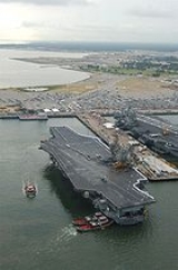
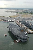
is located in Portsmouth, as are the Naval Medical Center, Portsmouth
, two historic and important facilities, as well as several smaller facilities. The shipyard was founded as the Gosport Shipyard on November 1, 1767, and has the county's first dry dock
. The name was changed after the American Civil War
. (Although it is located in Portsmouth, the name Norfolk was chosen to avoid confusion with another U.S. Navy shipyard at Portsmouth, New Hampshire
which is about 50 miles (80 km) north of Boston, Massachusetts
, at the southernmost tip of Maine
.)
, at Sewell's Point
near the mouth of Hampton Roads is the Norfolk Navy Base
, the central hub of the United States Navy
's Atlantic Fleet
. The base was founded in 1917, and is now the largest naval facility in the world.
(NAS Oceana) and Naval Amphibious Base Little Creek
(NAB Little Creek). NAS Oceana is the largest employer in Virginia Beach, and both bases there, like the Norfolk Navy Base, are considered to be the largest of their respective kinds in the world. Furthermore, adjacent to Oceana is NAVSEA Dam Neck
. Virginia Beach is the also the home of Fort Story
, operated by the United States Army
, which is located at Cape Henry
.
is a U.S. Navy facility in Chesapeake on the Southern Branch of the Elizabeth River. It began operations in 1849 and occupies approximately 490 acres (198.3 ha), including 407 acres (164.7 ha) of land, 14 acres (5.7 ha) of marsh, and 69 acres (27.9 ha) of surface water. It is currently considered part of the Norfolk Navy Base.
Chesapeake is also home to U.S. Naval Auxiliary Landing Field Fentress, an auxiliary landing facility for NAS Oceana.
The decision to call the region "Hampton Roads" was a political one. The area was referred to as "Tidewater" for many years by the local residents. The local baseball team was called the Tidewater Tides for years but is now called the Norfolk Tides
. When they first came to Tidewater, they adopted the local name to draw more fans.
of the counties they had formerly been located within.
However, in the second half of the 20th century, an unprecedented wave of city-county-town local government consolidations took place in South Hampton Roads and on the Virginia Peninsula
. Nowhere else in Virginia have rural areas and more dense cities been combined in such a manner as these two areas. The changes resulted in the area having Virginia's cities with the largest land areas and the most farming, even over 30 years after the consolidations in some instances.
, two counties, and five incorporated towns. There were also a number of political subdivisions which are now extinct, primarily due to growth and consolidation of local government (see section below).
Isle of Wight County
The following is a listing of these 11 extinct shire, counties, towns, and cities, with the approximate dates they existed:
s, tunnel
s and bridge-tunnel
s across the James
and Elizabeth
Rivers, the harbor of Hampton Roads and the Chesapeake Bay
. The area is bordered on the east by the Atlantic Ocean
, on the south by the State of North Carolina
, and on the west by several counties which are considered to be in the Southside Virginia region.
Virginia
The Commonwealth of Virginia , is a U.S. state on the Atlantic Coast of the Southern United States. Virginia is nicknamed the "Old Dominion" and sometimes the "Mother of Presidents" after the eight U.S. presidents born there...
in the United States
United States
The United States of America is a federal constitutional republic comprising fifty states and a federal district...
, and is part of the Virginia Beach-Norfolk-Newport News, VA-NC MSA (Metropolitan Statistical Area) with a population about 1.7 million.
Hampton Roads
Hampton Roads
Hampton Roads is the name for both a body of water and the Norfolk–Virginia Beach metropolitan area which surrounds it in southeastern Virginia, United States...
is the common name for the metropolitan area that surrounds the body of water of the same name. The land portion of Hampton Roads has been historically divided into two regions, South Hampton Roads on the south side, and the Virginia Peninsula
Virginia Peninsula
The Virginia Peninsula is a peninsula in southeast Virginia, USA, bounded by the York River, James River, Hampton Roads and Chesapeake Bay.Hampton Roads is the common name for the metropolitan area that surrounds the body of water of the same name...
on the north side. (Locally, South Hampton Roads is commonly called "the Southside", which is not to be confused with "Southside Virginia", which is a separate region of the south central portion of Virginia located farther inland.)
As of the 2010 Census, the Hampton Roads MSA is the fifth largest metropolitan area by size in the southeastern United States, and is the second-largest (after the Charlotte metro area
Charlotte metropolitan area
The Charlotte metropolitan area is a metropolitan area/region of North and South Carolina within and surrounding the city of Charlotte...
) between Washington, D.C. and Atlanta, Georgia.
U.S. military installations
Military of the United States
The United States Armed Forces are the military forces of the United States. They consist of the Army, Navy, Marine Corps, Air Force, and Coast Guard.The United States has a strong tradition of civilian control of the military...
military base
Military base
A military base is a facility directly owned and operated by or for the military or one of its branches that shelters military equipment and personnel, and facilitates training and operations. In general, a military base provides accommodations for one or more units, but it may also be used as a...
s.
City of Portsmouth
Norfolk Naval ShipyardNorfolk Naval Shipyard
The Norfolk Naval Shipyard, often called the Norfolk Navy Yard and abbreviated as NNSY, is a U.S. Navy facility in Portsmouth, Virginia, for building, remodeling, and repairing the Navy's ships. It's the oldest and largest industrial facility that belongs to the U.S. Navy as well as the most...
is located in Portsmouth, as are the Naval Medical Center, Portsmouth
Naval Medical Center Portsmouth (Portsmouth, Virginia)
The Naval Medical Center Portsmouth , formerly Naval Hospital Portsmouth, is a United States Navy medical center in Portsmouth, Virginia, United States. It is the oldest continuously running hospital in the Navy medical system....
, two historic and important facilities, as well as several smaller facilities. The shipyard was founded as the Gosport Shipyard on November 1, 1767, and has the county's first dry dock
Dry dock
A drydock is a narrow basin or vessel that can be flooded to allow a load to be floated in, then drained to allow that load to come to rest on a dry platform...
. The name was changed after the American Civil War
American Civil War
The American Civil War was a civil war fought in the United States of America. In response to the election of Abraham Lincoln as President of the United States, 11 southern slave states declared their secession from the United States and formed the Confederate States of America ; the other 25...
. (Although it is located in Portsmouth, the name Norfolk was chosen to avoid confusion with another U.S. Navy shipyard at Portsmouth, New Hampshire
Portsmouth, New Hampshire
Portsmouth is a city in Rockingham County, New Hampshire in the United States. It is the largest city but only the fourth-largest community in the county, with a population of 21,233 at the 2010 census...
which is about 50 miles (80 km) north of Boston, Massachusetts
Boston
Boston is the capital of and largest city in Massachusetts, and is one of the oldest cities in the United States. The largest city in New England, Boston is regarded as the unofficial "Capital of New England" for its economic and cultural impact on the entire New England region. The city proper had...
, at the southernmost tip of Maine
Maine
Maine is a state in the New England region of the northeastern United States, bordered by the Atlantic Ocean to the east and south, New Hampshire to the west, and the Canadian provinces of Quebec to the northwest and New Brunswick to the northeast. Maine is both the northernmost and easternmost...
.)
City of Norfolk
Across the Elizabeth RiverElizabeth River (Virginia)
The Elizabeth River is a tidal estuary forming an arm of Hampton Roads harbor at the southern end of Chesapeake Bay in southeast Virginia in the United States. It is located along the southern side of the mouth of the James River, between the cities of Portsmouth and Norfolk...
, at Sewell's Point
Sewell's Point
Sewells Point is a peninsula of land in the independent city of Norfolk, Virginia in the United States, located at the mouth of the salt-water port of Hampton Roads. Sewells Point is bordered by water on three sides, with Willoughby Bay to the north, Hampton Roads to the west, and the Lafayette...
near the mouth of Hampton Roads is the Norfolk Navy Base
Naval Station Norfolk
Naval Station Norfolk, in Norfolk, Virginia, is a base of the United States Navy, supporting naval forces in the United States Fleet Forces Command, those operating in the Atlantic Ocean, Mediterranean Sea, and Indian Ocean...
, the central hub of the United States Navy
United States Navy
The United States Navy is the naval warfare service branch of the United States Armed Forces and one of the seven uniformed services of the United States. The U.S. Navy is the largest in the world; its battle fleet tonnage is greater than that of the next 13 largest navies combined. The U.S...
's Atlantic Fleet
U.S. Atlantic Fleet
The United States Fleet Forces Command is an Atlantic Ocean theater-level component command of the United States Navy that provides naval resources that are under the operational control of the United States Northern Command...
. The base was founded in 1917, and is now the largest naval facility in the world.
City of Virginia Beach
Virginia Beach is home to the U.S. Navy's Naval Air Station OceanaNaval Air Station Oceana
Naval Air Station Oceana or NAS Oceana is a military airport located in Virginia Beach, Virginia, and is a United States Navy Master Jet Base. It is also known as Apollo Soucek Field, named after Lieutenant Apollo Soucek, a Navy Test Pilot who set the global altitude record in 1930 by flying a...
(NAS Oceana) and Naval Amphibious Base Little Creek
Naval Amphibious Base Little Creek
The Naval Amphibious Base, Little Creek is the major operating base for the Amphibious Forces in the United States Navy's Atlantic Fleet. The base comprises four locations in three states, including almost 12,000 acres of real estate. Its Little Creek location in Virginia Beach, Virginia totals...
(NAB Little Creek). NAS Oceana is the largest employer in Virginia Beach, and both bases there, like the Norfolk Navy Base, are considered to be the largest of their respective kinds in the world. Furthermore, adjacent to Oceana is NAVSEA Dam Neck
Fleet Training Center Dam Neck
Training Support Center Hampton Roads is the current name of the facility in Virginia Beach, Virginia, USA, which was long-known as "FTC Dam Neck". It is the home of the "Fleet Combat Training Center Atlantic" of the United States Navy.- Dam Neck Mills, U.S...
. Virginia Beach is the also the home of Fort Story
Fort Story
Formerly a sub-installation of Fort Eustis, Fort Story is a sub-installation of the United States Navy and Little Creek Amphibious Base...
, operated by the United States Army
United States Army
The United States Army is the main branch of the United States Armed Forces responsible for land-based military operations. It is the largest and oldest established branch of the U.S. military, and is one of seven U.S. uniformed services...
, which is located at Cape Henry
Cape Henry
Cape Henry is a cape on the Atlantic shore of Virginia north of Virginia Beach. It is the southern boundary of the entrance to Chesapeake Bay.Across the mouth of the bay to the north is Cape Charles...
.
City of Chesapeake
St. Julien's Creek AnnexSt. Julien's Creek Annex
St. Julien's Creek Annex is a U.S. naval support facility that provides administrative offices, light industrial shops, and storage facilities for tenant naval commands. Its primary mission is to provide a radar testing range and various administrative and warehousing structures for the Norfolk...
is a U.S. Navy facility in Chesapeake on the Southern Branch of the Elizabeth River. It began operations in 1849 and occupies approximately 490 acres (198.3 ha), including 407 acres (164.7 ha) of land, 14 acres (5.7 ha) of marsh, and 69 acres (27.9 ha) of surface water. It is currently considered part of the Norfolk Navy Base.
Chesapeake is also home to U.S. Naval Auxiliary Landing Field Fentress, an auxiliary landing facility for NAS Oceana.
The decision to call the region "Hampton Roads" was a political one. The area was referred to as "Tidewater" for many years by the local residents. The local baseball team was called the Tidewater Tides for years but is now called the Norfolk Tides
Norfolk Tides
The Norfolk Tides are a minor league baseball team in the Triple-A International League. They play at Harbor Park in Norfolk, Virginia. Since 2007 they have been a farm team of the Baltimore Orioles; prior to that, they had a 38-year affiliation with the New York Mets.-Franchise history:The...
. When they first came to Tidewater, they adopted the local name to draw more fans.
Local government
In Colonial times, and even in the first 150 years of the United States, much like Virginia as a whole, South Hampton Roads was in an almost constant state of change in terms of local government, largely due to growth, as counties were divided and towns were formed as the population grew. Some towns grew to become cities. Under the state constitutional changes in 1871, extant and future cities in Virginia became independent citiesIndependent city
An independent city is a city that does not form part of another general-purpose local government entity. These type of cities should not be confused with city-states , which are fully sovereign cities that are not part of any other sovereign state.-Historical precursors:In the Holy Roman Empire,...
of the counties they had formerly been located within.
However, in the second half of the 20th century, an unprecedented wave of city-county-town local government consolidations took place in South Hampton Roads and on the Virginia Peninsula
Virginia Peninsula
The Virginia Peninsula is a peninsula in southeast Virginia, USA, bounded by the York River, James River, Hampton Roads and Chesapeake Bay.Hampton Roads is the common name for the metropolitan area that surrounds the body of water of the same name...
. Nowhere else in Virginia have rural areas and more dense cities been combined in such a manner as these two areas. The changes resulted in the area having Virginia's cities with the largest land areas and the most farming, even over 30 years after the consolidations in some instances.
Current cities, counties and towns
The South Hampton Roads region includes five independent citiesIndependent city
An independent city is a city that does not form part of another general-purpose local government entity. These type of cities should not be confused with city-states , which are fully sovereign cities that are not part of any other sovereign state.-Historical precursors:In the Holy Roman Empire,...
, two counties, and five incorporated towns. There were also a number of political subdivisions which are now extinct, primarily due to growth and consolidation of local government (see section below).
Independent cities
- ChesapeakeChesapeake, VirginiaAs of the census of 2000, there were 199,184 people, 69,900 households, and 54,172 families residing in the city. The population density was 584.6 people per square mile . There were 72,672 housing units at an average density of 213.3 per square mile...
(formerly Norfolk CountyNorfolk County, VirginiaNorfolk County was a county of the South Hampton Roads in eastern Virginia in the United States that was created in 1691. After the American Civil War, for a period of about 100 years, portions of Norfolk County were lost and the territory of the county reduced as they became parts of the separate...
) - NorfolkNorfolk, VirginiaNorfolk is an independent city in the Commonwealth of Virginia in the United States. With a population of 242,803 as of the 2010 Census, it is Virginia's second-largest city behind neighboring Virginia Beach....
- PortsmouthPortsmouth, VirginiaPortsmouth is located in the Hampton Roads metropolitan area of the U.S. Commonwealth of Virginia. As of 2010, the city had a total population of 95,535.The Norfolk Naval Shipyard, often called the Norfolk Navy Yard, is a historic and active U.S...
- SuffolkSuffolk, VirginiaSuffolk is the largest city by area in Virginia, United States, and is located in the Hampton Roads metropolitan area. As of the 2010 census, the city had a total population of 84,585. Its median household income was $57,546.-History:...
- Virginia BeachVirginia Beach, VirginiaVirginia Beach is an independent city located in the Hampton Roads metropolitan area of Virginia, on the Atlantic Ocean at the mouth of the Chesapeake Bay...
(formerly Princess Anne CountyPrincess Anne County, VirginiaPrincess Anne County is a former county which was created in the British Colony of Virginia and the Commonwealth of Virginia in the United States in 1691. The county was merged into the city of Virginia Beach...
)
Counties
- Surry CountySurry County, VirginiaAs of the census of 2010, there were 7,058 people, 2,619 households, and 1,917 families residing in the county. The population density was 24 people per square mile . There were 3,294 housing units at an average density of 12 per square mile...
- Isle of Wight CountyIsle of Wight County, VirginiaAs of the census of 2010, there were 35,270 people, 11,319 households, and 8,670 families residing in the county. The population density was 94 people per square mile . There were 12,066 housing units at an average density of 38 per square mile...
Incorporated towns
Surry County- Town of ClaremontClaremont, VirginiaClaremont is an incorporated town in Surry County, Virginia, United States. The population was 343 at the 2000 census.- History :A granite marker in a circle in the center of town commemorates the landing here on May 5, 1607, of English settlers...
- Town of DendronDendron, VirginiaDendron is a town in Surry County, Virginia, United States. The population was 297 at the 2000 census.-Geography:Dendron is located at ....
- Town of SurrySurry, VirginiaSurry is an incorporated town in Surry County, Virginia, United States. The population was 262 at the 2000 census...
(also county seat)
Isle of Wight County
- Town of SmithfieldSmithfield, VirginiaSmithfield is a town in Isle of Wight County, in the South Hampton Roads subregion of the Hampton Roads region of Virginia in the United States. The population was 8,089 at the 2010 census....
- Town of WindsorWindsor, VirginiaWindsor is an incorporated town in Isle of Wight County in the Hampton Roads region of southeastern Virginia in the United States. It is located near the crossroads of U.S. Route 460 and U.S. Route 258. The population was 916 at the 2000 census...
Extinct political subdivisions
Exclusive of towns which became cities and still have the same name, no less than 2 shires, 6 counties, 1 town, and 2 entire cities no longer exist in the South Hampton Roads area. For search of genealogical, land, and other historical records, it may be necessary to find these old names.The following is a listing of these 11 extinct shire, counties, towns, and cities, with the approximate dates they existed:
- Elizabeth River Shire (1634–1636)
- Warrosquyoake ShireWarrosquyoake ShireWarrosquoake Shire was officially formed in 1634 in the Virginia colony, but had already been known as "Warascoyack County" before this...
(1634–1637) - New Norfolk County (1636–1637)
- Upper Norfolk County (1637–1646)
- Lower Norfolk County (1637–1691)
- Nansemond CountyNansemond County, VirginiaNansemond County is an extinct county which was located in Virginia Colony and the Commonwealth of Virginia in the United States, from 1646 until 1972...
(1646-1972) - Norfolk CountyNorfolk County, VirginiaNorfolk County was a county of the South Hampton Roads in eastern Virginia in the United States that was created in 1691. After the American Civil War, for a period of about 100 years, portions of Norfolk County were lost and the territory of the county reduced as they became parts of the separate...
(1691–1963) - Princess Anne CountyPrincess Anne County, VirginiaPrincess Anne County is a former county which was created in the British Colony of Virginia and the Commonwealth of Virginia in the United States in 1691. The county was merged into the city of Virginia Beach...
(1691–1963) - Town of BerkleyBerkley, VirginiaBerkley was an incorporated town in Norfolk County, Virginia. Chartered by an Act of Assembly in 1890, the Town of Berkley was located directly across the eastern branch of the Elizabeth River from the City of Norfolk in the South Hampton Roads area....
(unknown-1906) - South NorfolkSouth Norfolk, VirginiaSouth Norfolk was an independent city in the South Hampton Roads region of eastern Virginia and is now a section of the City of Chesapeake, one of the cities of Hampton Roads which surround the harbor of Hampton Roads and are linked by the Hampton Roads Beltway.-History:Located a few miles south of...
(1919–1963) - City of NansemondNansemond, VirginiaNansemond is an extinct independent city which was located in the State of Virginia in the United States from 1972 until 1974. It was created from Nansemond County, Virginia, and is now part of the independent city of Suffolk, Virginia.-History:...
(1972–1974)
Highways, bridges, tunnels, bridge-tunnels
Generally surrounded by water, the South Hampton Roads region is accessed from the north by a network of highways, bridgeBridge
A bridge is a structure built to span physical obstacles such as a body of water, valley, or road, for the purpose of providing passage over the obstacle...
s, tunnel
Tunnel
A tunnel is an underground passageway, completely enclosed except for openings for egress, commonly at each end.A tunnel may be for foot or vehicular road traffic, for rail traffic, or for a canal. Some tunnels are aqueducts to supply water for consumption or for hydroelectric stations or are sewers...
s and bridge-tunnel
Bridge-tunnel
A fixed link, fixed crossing, or bridge-tunnel is a persistent, unbroken road or rail connection across water that uses some combination of bridges, tunnels, and causeways and does not involve intermittent connections such as drawbridges or ferries.The Confederation Bridge was commonly referred to...
s across the James
James River (Virginia)
The James River is a river in the U.S. state of Virginia. It is long, extending to if one includes the Jackson River, the longer of its two source tributaries. The James River drains a catchment comprising . The watershed includes about 4% open water and an area with a population of 2.5 million...
and Elizabeth
Elizabeth River (Virginia)
The Elizabeth River is a tidal estuary forming an arm of Hampton Roads harbor at the southern end of Chesapeake Bay in southeast Virginia in the United States. It is located along the southern side of the mouth of the James River, between the cities of Portsmouth and Norfolk...
Rivers, the harbor of Hampton Roads and the Chesapeake Bay
Chesapeake Bay
The Chesapeake Bay is the largest estuary in the United States. It lies off the Atlantic Ocean, surrounded by Maryland and Virginia. The Chesapeake Bay's drainage basin covers in the District of Columbia and parts of six states: New York, Pennsylvania, Delaware, Maryland, Virginia, and West...
. The area is bordered on the east by the Atlantic Ocean
Atlantic Ocean
The Atlantic Ocean is the second-largest of the world's oceanic divisions. With a total area of about , it covers approximately 20% of the Earth's surface and about 26% of its water surface area...
, on the south by the State of North Carolina
North Carolina
North Carolina is a state located in the southeastern United States. The state borders South Carolina and Georgia to the south, Tennessee to the west and Virginia to the north. North Carolina contains 100 counties. Its capital is Raleigh, and its largest city is Charlotte...
, and on the west by several counties which are considered to be in the Southside Virginia region.
Major bridges, tunnels, and bridge-tunnels
- Hampton Roads Bridge-TunnelHampton Roads Bridge-TunnelThe Hampton Roads Bridge-Tunnel is the -long Hampton Roads crossing for Interstate 64 and U.S. Route 60. It is a four-lane facility comprising bridges, trestles, man-made islands, and tunnels under the main shipping channels for Hampton Roads harbor in the southeastern portion of Virginia in the...
- Monitor-Merrimac Memorial Bridge-TunnelMonitor-Merrimac Memorial Bridge-TunnelMonitor-Merrimac Memorial Bridge-Tunnel is the 4.6 mile-long Hampton Roads crossing for Interstate 664 in the southeastern portion of Virginia in the United States...
- James River BridgeJames River BridgeThe James River Bridge is a four-lane divided highway lift bridge across the James River in the U.S. state of Virginia. Owned and operated by the Virginia Department of Transportation, it carries U.S. Route 17, U.S. Route 258, and State Route 32 across the river near its mouth at Hampton Roads...
- Chesapeake Bay Bridge-TunnelChesapeake Bay Bridge-TunnelThe Chesapeake Bay Bridge-Tunnel is a long fixed link crossing the mouth of the Chesapeake Bay and connecting the Delmarva Peninsula's Eastern Shore of Virginia with Virginia Beach and the metropolitan area of Hampton Roads, Virginia...
- Berkley BridgeBerkley Bridge (Virginia)The Berkley Bridge is a double-leaf bascule bridge across the Eastern Branch of the Elizabeth River in Norfolk, Virginia, United States. It carries Interstate 264, U.S. Route 460 Alternate, and State Route 337 across the river, connecting the Berkley neighborhood south of the river with downtown...
- Downtown TunnelDowntown TunnelThe Downtown Tunnel on Interstate 264 crosses the Southern Branch of the Elizabeth River in the South Hampton Roads area. It links the independent City of Portsmouth with the independent City of Norfolk...
- Midtown TunnelMidtown TunnelThe Midtown Tunnel crosses the main channel of the Elizabeth River in the South Hampton Roads area. It links the independent City of Portsmouth with the independent City of Norfolk. It carries U.S. Highway 58 and operates without tolls.- History :...
- Gilmerton BridgeGilmerton BridgeGilmerton Bridge is a Twin Bascule Drawbridge which spans the southern branch of the Elizabeth River in the City of Chesapeake in South Hampton Roads in southeastern Virginia. Completed in 1938, it carries U.S. Highway 13 and U.S. Highway 460 and is part of the Military Highway...
- High Rise BridgeHigh Rise BridgeHigh Rise Bridge is a bascule drawbridge which carries a portion of the Hampton Roads Beltway designated as Interstate 64 across the Southern Branch of the Elizabeth River in Chesapeake, Virginia....
- Jordan BridgeJordan BridgeJordan Bridge was a tolled highway lift bridge which carried State Route 337 over the southern branch of the Elizabeth River from the City of Portsmouth into the City of Chesapeake in South Hampton Roads, Virginia....
- Steel BridgeDominion Boulevard Steel BridgeDominion Boulevard Steel Bridge is a double leaf bascule, two lane drawbridge which spans the southern branch of the Elizabeth River in the City of Chesapeake in South Hampton Roads in southeastern Virginia. It carries U.S. Route 17 in Virginia which is Dominion Boulevard...
Interstate highways and other freeways
- Interstate 64
- Interstate 264Interstate 264 (Virginia)Interstate 264 is an Interstate Highway in the U.S. state of Virginia. It runs from a junction with Interstate 64 and Interstate 664 near Bowers Hill in Chesapeake east into Portsmouth and through the Downtown Tunnel under the South Branch of the Elizabeth River into Norfolk...
- Interstate 464
- Interstate 564
- Interstate 664
- Hampton Roads BeltwayHampton Roads BeltwayThe Hampton Roads Beltway is a loop of Interstate 64 and Interstate 664, which links the communities of the Virginia Peninsula and South Hampton Roads which surround the body of water known as Hampton Roads and comprise much of the region of the same name in the southeastern portion of Virginia in...
- Virginia Beach Expressway
- Chesapeake Expressway
U.S. Highways and major state highways
- U.S. Route 13
- U.S. Route 17
- U.S. Route 58
- U.S. Route 60
- U.S. Route 258
- U.S. Route 460
- State Route 10
- State Route 31
- State Route 32
- State Route 143
- State Route 164
- State Route 168
- State Route 337
See also
- Battle of Hampton RoadsBattle of Hampton RoadsThe Battle of Hampton Roads, often referred to as either the Battle of the Monitor and Merrimack or the Battle of Ironclads, was the most noted and arguably most important naval battle of the American Civil War from the standpoint of the development of navies...
- Jamestown ExpositionJamestown ExpositionThe Jamestown Exposition was one of the many world's fairs and expositions that were popular in the United States in the early part of the 20th century...
- Sewell's PointSewell's PointSewells Point is a peninsula of land in the independent city of Norfolk, Virginia in the United States, located at the mouth of the salt-water port of Hampton Roads. Sewells Point is bordered by water on three sides, with Willoughby Bay to the north, Hampton Roads to the west, and the Lafayette...
- Willoughby SpitWilloughby SpitWilloughby Spit is a peninsula of land in the independent city of Norfolk, Virginia in the United States. It is bordered by water on three sides: the Chesapeake Bay to the north, Hampton Roads to the west, and Willoughby Bay to the south.- History :...
- Ocean View
- Lambert's PointLambert's PointLamberts Point is a point of land on the south shore of the Elizabeth River near the downtown area of the independent city of Norfolk in the South Hampton Roads region of eastern Virginia, United States...
- Bower's Hill
- Craney IslandCraney Island (Virginia)Craney Island is a point of land in the independent city of Portsmouth in the South Hampton Roads region of eastern Virginia in the United States. The location, formerly in Norfolk County, is near the mouth of the Elizabeth River opposite Lambert's Point on Hampton Roads. It is managed by the U.S...
- Military HighwayMilitary HighwayMilitary Highway is a four-lane roadway built in the South Hampton Roads region of eastern Virginia, USA during World War II.- Original construction :...