
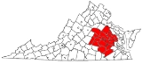
Richmond-Petersburg
Encyclopedia
U.S. state
A U.S. state is any one of the 50 federated states of the United States of America that share sovereignty with the federal government. Because of this shared sovereignty, an American is a citizen both of the federal entity and of his or her state of domicile. Four states use the official title of...
of Virginia
Virginia
The Commonwealth of Virginia , is a U.S. state on the Atlantic Coast of the Southern United States. Virginia is nicknamed the "Old Dominion" and sometimes the "Mother of Presidents" after the eight U.S. presidents born there...
in the United States
United States
The United States of America is a federal constitutional republic comprising fifty states and a federal district...
. As of 2010, it had a population of 1,258,251, making it the 43rd largest MSA in the country. It straddles the fall line
Fall line
A fall line is a geomorphologic unconformity between an upland region of relatively hard crystalline basement rock and a coastal plain of softer sedimentary rock. A fall line is typically prominent when crossed by a river, for there will often be rapids or waterfalls...
, where the Coastal Plain
Coastal plain
A coastal plain is an area of flat, low-lying land adjacent to a seacoast and separated from the interior by other features. One of the world's longest coastal plains is located in eastern South America. The southwestern coastal plain of North America is notable for its species diversity...
and the Piedmont come together on the James River
James River (Virginia)
The James River is a river in the U.S. state of Virginia. It is long, extending to if one includes the Jackson River, the longer of its two source tributaries. The James River drains a catchment comprising . The watershed includes about 4% open water and an area with a population of 2.5 million...
at Richmond and the Appomattox River
Appomattox River
The Appomattox River is a tributary of the James River, approximately long, in central and eastern Virginia in the United States, named for the Appomattocs Indian tribe who lived along its lower banks in the 17th century...
at Petersburg. The English established each as colonial ports in the 17th century.
From 2000 to 2010, the Greater Richmond metro area experienced continuous population growth, adding over 161,294 residents for an increase of over 14.70%.
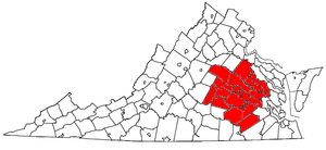
Richmond, VA MSA is a U.S. Metropolitan Statistical Area (MSA) in Virginia as defined by the United States Office of Management and Budget (OMB) as of June 2003. Currently the area covered by the MSA coincides precisely with the Richmond-Petersburg region of Virginia.
Independent cities
Since a state constitutional change in 1871, all cities in Virginia are independent citiesIndependent city
An independent city is a city that does not form part of another general-purpose local government entity. These type of cities should not be confused with city-states , which are fully sovereign cities that are not part of any other sovereign state.-Historical precursors:In the Holy Roman Empire,...
and they are not legally located in any county. The OMB considers these independent cities to be county-equivalent
County-equivalent
A county-equivalent in the United States is a term used by the federal government to describe one of the two following governmental subdivisions:#A unit of local government in certain states which is comparable to a county as found in most states....
s for the purpose of defining MSAs in Virginia. Each MSA is listed by its counties, then cities, each in alphabetical order, and not by size.
The area is composed of four independent cities (listed in order of population):
- RichmondRichmond, VirginiaRichmond is the capital of the Commonwealth of Virginia, in the United States. It is an independent city and not part of any county. Richmond is the center of the Richmond Metropolitan Statistical Area and the Greater Richmond area...
- PetersburgPetersburg, VirginiaPetersburg is an independent city in Virginia, United States located on the Appomattox River and south of the state capital city of Richmond. The city's population was 32,420 as of 2010, predominantly of African-American ethnicity...
- HopewellHopewell, VirginiaHopewell is an independent city in the Commonwealth of Virginia. The population was 22,591 at the 2010 Census . It is in Tri-Cities area of the Richmond-Petersburg region and is a portion of the Richmond Metropolitan Statistical Area...
- Colonial HeightsColonial Heights, VirginiaColonial Heights is an independent city in Virginia, United States. The population was 17,411 as of 2010. The Bureau of Economic Analysis combines the City of Colonial Heights with Dinwiddie County for statistical purposes...
The three smaller cities (Petersburg, Hopewell, and Colonial Heights) are located near each other in an area south of Richmond and are known collectively as the "tri-cities".
Counties
- Charles CityCharles City County, VirginiaAs of the census of 2000, there were 6,926 people, 2,670 households, and 1,975 families residing in the county. The population density was 38 people per square mile . There were 2,895 housing units at an average density of 16 per square mile...
- ChesterfieldChesterfield County, VirginiaChesterfield County is a county located in the Commonwealth of Virginia, a state of the United States. In 2010, its population was estimated to be 316,236. Chesterfield County is now the fourth-largest municipality in Virginia . Its county seat is Chesterfield...
- DinwiddieDinwiddie County, VirginiaDinwiddie County is a county located in the Commonwealth of Virginia. As of 2010, the population was 28,001. Its county seat is Dinwiddie.- History :...
- GoochlandGoochland County, VirginiaGoochland County is a county located in the Commonwealth of Virginia. As of 2010, the population was 21,717. Its county seat is Goochland. It is located in the Richmond-Petersburg region and is a portion of the Richmond Metropolitan Statistical Area ....
- HanoverHanover County, VirginiaAs of the census of 2000, there were 86,320 people, 31,121 households, and 24,461 families residing in the county. The population density was 183 people per square mile . There were 32,196 housing units at an average density of 68 per square mile...
- HenricoHenrico County, VirginiaHenrico is a county located in the Commonwealth of Virginia, a state of the United States. As of 2010, Henrico was home to 306,935 people. It is located in the Richmond-Petersburg region and is a portion of the Richmond Metropolitan Statistical Area...
- New KentNew Kent County, VirginiaAt the 2000 census, there were 13,462 people, 4,925 households and 3,895 families residing in the county. The population density was 64 per square mile . There were 5,203 housing units at an average density of 25 per square mile...
- PowhatanPowhatan County, VirginiaAs of the census of 2000, there were 22,377 people, 7,258 households, and 5,900 families residing in the county. The population density was 86 people per square mile . There were 7,509 housing units at an average density of 29 per square mile...
- Prince GeorgePrince George County, VirginiaAs of the census of 2000, there were 33,047 people, 10,159 households, and 8,096 families residing in the county. The population density was 124 people per square mile . There were 10,726 housing units at an average density of 40 per square mile...
Additional counties (cities) within Metropolitan Statistical Area
These counties (cities) are parts of the Richmond, MSA dictated by the OMB.- Amelia CountyAmelia County, VirginiaAs of the census of 2000, there were 11,400 people, 4,240 households, and 3,175 families residing in the county. The population density was 32 people per square mile . There were 4,609 housing units at an average density of 13 per square mile...
- Caroline CountyCaroline County, VirginiaCaroline County is a county located in the Commonwealth of Virginia. As of 2010, the population was 28,545. Its county seat is Bowling Green. Caroline County is also home to The Meadow stables, the birthplace of the renowned racehorse Secretariat, winner of the 1973 Kentucky Derby, Preakness and...
- Cumberland CountyCumberland County, VirginiaAs of the census of 2000, there were 9,017 people, 3,528 households, and 2,487 families residing in the county. The population density was 30 people per square mile . There were 4,085 housing units at an average density of 14 per square mile...
- King and Queen CountyKing and Queen County, VirginiaAs of the census of 2000, there were 6,630 people, 2,673 households, and 1,897 families residing in the county. The population density was 21 people per square mile . There were 3,010 housing units at an average density of 10 per square mile...
- King William CountyKing William County, VirginiaAs of the census of 2000, there were 13,146 people, 4,846 households, and 3,784 families residing in the county. The population density was 48 people per square mile . There were 5,189 housing units at an average density of 19 per square mile...
- Louisa CountyLouisa County, VirginiaLouisa County is a county located in the Commonwealth of Virginia. As of 2010, the population was 33,153. The county seat is Louisa.- History :...
- Sussex CountySussex County, VirginiaAs of the census of 2000, there were 12,504 people, 4,126 households, and 2,809 families residing in the county. The population density was 26 people per square mile . There were 4,653 housing units at an average density of 10 per square mile...
Selected unincorporated towns and communities
The Richmond-Petersburg metropolitan area includes many unincorporated towns and communities.Note: This is only a partial listing.
- Atlee
- Beach
- Bon AirBon Air, VirginiaBon Air is a census-designated place in Chesterfield County, Virginia, United States. The population was 16,366 at the 2010 census. The community is considered a suburb of the independent city of Richmond in the Richmond-Petersburg region, and shares a post office with Richmond...
- Centralia
- ChesterChester, VirginiaChester is a census-designated place in Chesterfield County, Virginia, United States. The population was 20,987 at the 2010 census.-History:...
- Chesterfield
- DisputantaDisputanta, VirginiaDisputanta is an unincorporated community in Prince George County, Virginia, United States in the Richmond-Petersburg region and is a portion of the Richmond Metropolitan Statistical Area...
- EnonEnon, VirginiaEnon is a census-designated place in Chesterfield County, Virginia, United States, just east of Chester. The population as of the 2010 Census was 3,466. It has the zip code 23836 and GPS coordinates 37.3504000, -77.3254000....
- EttrickEttrick, VirginiaEttrick is a census-designated place in Chesterfield County, Virginia, United States. The population was 6,682 at the 2010 census. The town is home to Virginia State University and the Petersburg Amtrak train station....
- Fair OaksFair Oaks, VirginiaFair Oaks is an unincorporated community located in Henrico County, Virginia. Fair Oaks Station was located on the Richmond and York River Railroad and played a role in the Peninsula Campaign in 1862 during the American Civil War. A major battle was fought nearby, known variously as the Battle of...
- Glen AllenGlen Allen, VirginiaGlen Allen is a census-designated place in Henrico County, Virginia, United States. The population was 12,562 at the 2000 census.-Geography:...
- Glendale
- Highland SpringsHighland Springs, VirginiaHighland Springs is a census-designated place in Henrico County, Virginia, United States. The population was 15,137 at the 2000 census.- History :...
- Kingsland
- LakesideLakeside, VirginiaLakeside is a census-designated place in Henrico County, Virginia, United States. The population was 11,157 at the 2000 census.-Geography:Lakeside is located at ....
- LaurelLaurel, VirginiaLaurel is a census-designated place in Henrico County, Virginia, United States. The population was 14,875 at the 2000 census.-Geography:Laurel is located at ....
- Matoaka
- MechanicsvilleMechanicsville, VirginiaMechanicsville is the name of four places in the Commonwealth of Virginia in the United States of America:*Mechanicsville, Hanover County, Virginia*Mechanicsville, Loudoun County, Virginia*Mechanicsville, Rockbridge County, Virginia...
- MidlothianMidlothian, VirginiaMidlothian is an unincorporated community in Chesterfield County, Virginia, United States. Founded over 300 years ago as a coal mining village, it is now a suburban community located in the Southside of Richmond well beyond the city limits of Richmond in the Richmond–Petersburg region.It was named...
- MontroseMontrose, VirginiaMontrose is a census-designated place in Henrico County, Virginia, United States. The population was 7,018 at the 2000 census.-Geography:Montrose is located at ....
- Moseley
- New BohemiaNew Bohemia, VirginiaNew Bohemia is an unincorporated community in Prince George County, Virginia, United States, along U.S. Route 460.New Bohemia was established early in the 20th century by a group of Bohemians and Slovaks from the industrial and mining sections of western Pennsylvania and eastern Ohio...
- Prince GeorgePrince George, VirginiaPrince George is a census-designated place in and the county seat of Prince George County, Virginia, United States. The population as of the 2010 Census was 2,066. It is in the metro area of Richmond, Virginia. The elevation is at 131 feet.-References:...
- SandstonSandston, VirginiaSandston is a census-designated place in Henrico County, Virginia, United States, near the state capital of Richmond. The population as of the 2010 Census was 7,571. Sandston is adjacent to the Richmond International Airport.-History:...
- Short PumpShort Pump, VirginiaShort Pump is a census-designated place in Henrico County, Virginia, United States. The population was 182 at the 2000 census.The village of Short Pump, located at the intersection of Three Chopt Road, Richmond Turnpike and Pouncey Tract Road, was named for the short handled pump beneath the...
- Soloman's Store
- VarinaVarina, VirginiaVarina is a former unincorporated town and current magisterial district in the easternmost portion of Henrico County, Virginia, United States....
- WinterpockWinterpock, VirginiaWinterpock is an unincorporated community in western Chesterfield County, Virginia, United States. Winterpock does not have its own post office....
Population
| Greater Richmond Population by year |
|
| 1990 | 865,640 |
| 2000 | 1,100,121 |
| 2001 | 1,111,088 |
| 2002 | 1,124,822 |
| 2003 | 1,139,092 |
| 2004 | 1,154,589 |
| 2005 | 1,173,410 |
| 2006 | 1,194,008 |
| 2007 | 1,212,977 |
| 2008 | 1,225,626 |
| 2010 | 1,258,251 |
The Richmond Metropolitan Statistical Area (MSA) which includes 3 other cities (Petersburg, Hopewell and Colonial Heights), and adjacent counties is home to approximately 1.25 million Virginians).
The region is located approximately equidistant from Northern Virginia
Northern Virginia
Northern Virginia consists of several counties and independent cities in the Commonwealth of Virginia, in a widespread region generally radiating southerly and westward from Washington, D.C...
, Hampton Roads
Hampton Roads
Hampton Roads is the name for both a body of water and the Norfolk–Virginia Beach metropolitan area which surrounds it in southeastern Virginia, United States...
, and Lynchburg
Lynchburg, Virginia
Lynchburg is an independent city in the Commonwealth of Virginia. The population was 75,568 as of 2010. Located in the foothills of the Blue Ridge Mountains along the banks of the James River, Lynchburg is known as the "City of Seven Hills" or "The Hill City." Lynchburg was the only major city in...
. The area is home to the state's center of gravity of population—which, in 1980, was located thirty miles west of Richmond near the Powhatan-Goochland County border.
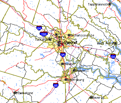
Expressways and Interstate highways
Several of the most heavily traveled highways in the state transverse the area, which includes the junctions of Interstate 64Interstate 64
Interstate 64 is an Interstate Highway in the Midwestern and Southeastern United States. Its western terminus is at I-70, U.S. 40, and U.S. 61 in Wentzville, Missouri. Its eastern terminus is at an interchange with I-264 and I-664 at Bowers Hill in Chesapeake, Virginia. As I-64 is concurrent with...
(which runs east-west), and Interstate Highways 85
Interstate 85
Interstate 85 is a major interstate highway in the Southeastern United States. Its current southern terminus is at an interchange with Interstate 65 in Montgomery, Alabama; its northern terminus interchanges with Interstate 95 in Petersburg, Virginia, near Richmond...
and 95
Interstate 95 in Virginia
In the Commonwealth of Virginia, Interstate 95 runs through the state. It runs concurrently for with Interstate 64 in Richmond, and meets the northern terminus of Interstate 85 in Petersburg. Though Interstate 95 was originally planned to go straight through Washington, D.C., it was instead...
(which run north-south). The area is also served by a comprehensive network of Interstate bypasses and spurs, and several non-interstate expressways. Several of these local roads are funded by tolls, although tolls have long been removed from the area's first limited access highway, the Richmond-Petersburg Turnpike
Richmond-Petersburg Turnpike
The Richmond-Petersburg Turnpike was a toll road located in the Richmond-Petersburg region of central Virginia, USA.After World War II, major traffic congestion occurred in the area around Richmond and Petersburg along U.S. Route 1 and U.S. Route 301...
, which opened in 1958, and now forms a portion of I-95 and I-85. I-295 opened in 1992, was the last segment of Virginia's interstate system and forms an eastern bypass of Richmond and Petersburg.
Railway network
The Richmond-Petersburg region is also located along several major rail lines operated by CSX TransportationCSX Transportation
CSX Transportation operates a Class I railroad in the United States known as the CSX Railroad. It is the main subsidiary of the CSX Corporation. The company is headquartered in Jacksonville, Florida, and owns approximately 21,000 route miles...
and the Norfolk Southern Railway
Norfolk Southern Railway
The Norfolk Southern Railway is a Class I railroad in the United States, owned by the Norfolk Southern Corporation. With headquarters in Norfolk, Virginia, the company operates 21,500 route miles in 22 eastern states, the District of Columbia and the province of Ontario, Canada...
.
The area has two passenger stations served by Amtrak
Amtrak
The National Railroad Passenger Corporation, doing business as Amtrak , is a government-owned corporation that was organized on May 1, 1971, to provide intercity passenger train service in the United States. "Amtrak" is a portmanteau of the words "America" and "track". It is headquartered at Union...
.
- Main Street Station (station code RVM), located in downtown Richmond
- Staples Mill Road Station (station code RVR), located in Henrico County
- Petersburg Station (station code PTB), located in EttrickEttrick, VirginiaEttrick is a census-designated place in Chesterfield County, Virginia, United States. The population was 6,682 at the 2010 census. The town is home to Virginia State University and the Petersburg Amtrak train station....
The Department of Rail and Public Transportation of the State of Virginia has studies underway for extending high speed passenger rail service to the Virginia Peninsula
Virginia Peninsula
The Virginia Peninsula is a peninsula in southeast Virginia, USA, bounded by the York River, James River, Hampton Roads and Chesapeake Bay.Hampton Roads is the common name for the metropolitan area that surrounds the body of water of the same name...
and South Hampton Roads
South Hampton Roads
South Hampton Roads is a region located in the extreme southeastern portion of Virginia in the United States, and is part of the Virginia Beach-Norfolk-Newport News, VA-NC MSA with a population about 1.7 million....
areas with a rail connection at Richmond to service along both the Northeast Corridor
Northeast Corridor
The Northeast Corridor is a fully electrified railway line owned primarily by Amtrak serving the Northeast megalopolis of the United States from Boston in the north, via New York to Washington, D.C. in the south, with branches serving other cities...
and the Southeast High Speed Rail Corridor
Southeast High Speed Rail Corridor
The Southeast High Speed Rail Corridor is a passenger rail transportation project in the United States to extend high speed passenger rail services from Washington, DC south through Richmond and Petersburg in Virginia through Raleigh and Charlotte in North Carolina and connect with the existing...
. http://www.drpt.state.va.us/projects/current/hampton.aspx.
Another project, known as Transdominion Express
Transdominion Express
thumb|450px|right|Map of proposed stations and routes of Virginia Transdominion ExpressThe Transdominion Express is a proposed passenger rail transportation project in Virginia in the United States....
, would extend from Richmond west to Lynchburg
Lynchburg, Virginia
Lynchburg is an independent city in the Commonwealth of Virginia. The population was 75,568 as of 2010. Located in the foothills of the Blue Ridge Mountains along the banks of the James River, Lynchburg is known as the "City of Seven Hills" or "The Hill City." Lynchburg was the only major city in...
and from Washington, DC (Alexandria
Alexandria, Virginia
Alexandria is an independent city in the Commonwealth of Virginia. As of 2009, the city had a total population of 139,966. Located along the Western bank of the Potomac River, Alexandria is approximately six miles south of downtown Washington, D.C.Like the rest of northern Virginia, as well as...
) south via an existing Virginia Railway Express
Virginia Railway Express
The Virginia Railway Express is a regional/ commuter rail service that connects the Northern Virginia suburbs to Union Station in Washington, D.C., via two lines: the Fredericksburg Line from Fredericksburg, Virginia, and the Manassas Line from Broad Run/Airport station in Bristow,...
route to Manassas
Manassas, Virginia
The City of Manassas is an independent city surrounded by Prince William County and the independent city of Manassas Park in the Commonwealth of Virginia in the United States. Its population was 37,821 as of 2010. Manassas also surrounds the county seat for Prince William County but that county...
, extending on south to Charlottesville
Charlottesville, Virginia
Charlottesville is an independent city geographically surrounded by but separate from Albemarle County in the Commonwealth of Virginia, United States, and named after Charlotte of Mecklenburg-Strelitz, the queen consort of King George III of the United Kingdom.The official population estimate for...
, Lynchburg, Roanoke
Roanoke, Virginia
Roanoke is an independent city in the Mid-Atlantic U.S. state of Virginia and is the tenth-largest city in the Commonwealth. It is located in the Roanoke Valley of the Roanoke Region of Virginia. The population within the city limits was 97,032 as of 2010...
and Bristol
Bristol, Virginia
Bristol is an independent city in Virginia, United States, bounded by Washington County, Virginia, Bristol, Tennessee, and Sullivan County, Tennessee....
on the Tennessee
Tennessee
Tennessee is a U.S. state located in the Southeastern United States. It has a population of 6,346,105, making it the nation's 17th-largest state by population, and covers , making it the 36th-largest by total land area...
border. http://www.drpt.state.va.us/downloads/files/bristolmap.gif
Sea and airport facilities
An international deepwater terminal is located at the Port of Richmond on the James RiverJames River (Virginia)
The James River is a river in the U.S. state of Virginia. It is long, extending to if one includes the Jackson River, the longer of its two source tributaries. The James River drains a catchment comprising . The watershed includes about 4% open water and an area with a population of 2.5 million...
which is navigable for shipping to Hampton Roads
Hampton Roads
Hampton Roads is the name for both a body of water and the Norfolk–Virginia Beach metropolitan area which surrounds it in southeastern Virginia, United States...
, the Chesapeake Bay
Chesapeake Bay
The Chesapeake Bay is the largest estuary in the United States. It lies off the Atlantic Ocean, surrounded by Maryland and Virginia. The Chesapeake Bay's drainage basin covers in the District of Columbia and parts of six states: New York, Pennsylvania, Delaware, Maryland, Virginia, and West...
, and the Atlantic Ocean
Atlantic Ocean
The Atlantic Ocean is the second-largest of the world's oceanic divisions. With a total area of about , it covers approximately 20% of the Earth's surface and about 26% of its water surface area...
.
Richmond International Airport
Richmond International Airport
- Accidents and incidents :*In 1996, Eastwind Airlines Flight 517 from Trenton experienced loss of rudder control while on approach to Richmond, however rudder control was regained shortly after and the aircraft landed normally. There was one minor injury....
is located in Henrico County, five miles east of the city center. The airport serves primarily domestic destinations in the Midwest, South, and Northeast as well as Eastern Canada.
Politics
| Year | GOP Republican Party (United States) The Republican Party is one of the two major contemporary political parties in the United States, along with the Democratic Party. Founded by anti-slavery expansion activists in 1854, it is often called the GOP . The party's platform generally reflects American conservatism in the U.S... |
DEM Democratic Party (United States) The Democratic Party is one of two major contemporary political parties in the United States, along with the Republican Party. The party's socially liberal and progressive platform is largely considered center-left in the U.S. political spectrum. The party has the lengthiest record of continuous... |
Others |
|---|---|---|---|
| 2008 | 46.5% 291,304 | 52.8% 330,528 | 0.7% 4,369 |
| 2004 | 55.0% 287,810 | 44.4% 232,240 | 0.6% 3,239 |
| 2000 | 54.4% 239,734 | 43.1% 189,867 | 2.6% 11,269 |
| 1996 | 50.6% 200,687 | 42.4% 168,190 | 6.9% 27,387 |
| 1992 | 44.9% 184,241 | 40.0% 164,116 | 15.0% 61,538 |
| 1988 | 62.4% 224,861 | 36.7% 132,277 | 0.9% 3,406 |
| 1984 | 64.1% 231,956 | 35.4% 128,044 | 0.5% 1,792 |
| 1980 | 55.9% 178,936 | 39.5% 126,245 | 4.6% 14,797 |
| 1976 | 53.8% 155,979 | 44.1% 127,693 | 2.1% 6,044 |
| 1972 | 70.5% 176,154 | 27.8% 69,598 | 1.7% 4,185 |
| 1968 | 46.5% 109,988 | 30.8% 72,876 | 22.7% 53,648 |
| 1964 | 55.1% 103,295 | 44.9% 84,184 | 0.1% 144 |
| 1960 | 58.4% 75,523 | 40.9% 52,945 | 0.7% 905 |
Economy
The applicable Metropolitan Statistical Area for the Richmond-Petersburg region is the Richmond, VA MSA, which as of 2006 is identical to the region defined in this article. The Richmond MSA provides employment for a total of approximately 472,000 workers. In order of the number of workers, the major employment categories of the region are services; retail trade; manufacturing; state government; finance, insurance and real estate; local government; construction; wholesale trade; transportation and public utilities and federal government. Within the manufacturing category of some 63,700 employees, the largest category of workers is in the tobacco industry. Other important manufacturing categories are chemicals, printing and publishing, paper, and wood manufactures.This economic diversity, which is typical of the entire Richmond-Petersburg region, helps to insulate it from hardship due to economic fluctuation in particular sectors of the economy. The region's central location also allows it to benefit from growth in other regions of Virginia and the state as a whole.