

York River (Virginia)
Encyclopedia
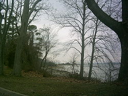
The York River is a navigable estuary
, approximately 34 miles (54.7 km) long, in eastern Virginia
in the United States
. It ranges in width from 1 miles (1.6 km) at its head to 2.5 miles (4 km) near its mouth on the west side of Chesapeake Bay
. Its watershed drains an area including portions of 17 counties http://www.vagazette.com/news/va-news3_052406may24,0,4491772.story?coll=va-news of the coastal plain
of Virginia north and east of Richmond
.
Its banks were inhabited by indigenous peoples for thousands of years. In 2003 evidence was found of the likely site of Werowocomoco
, one of two capitals used by the paramount chief Powhatan
before 1609. The site was inhabited since 1200 CE as a major village. Enormously important in later U.S. history, the river was also the scene of early settlements of the Virginia Colony. It was the site of significant events and battles in both the American Revolutionary War
and the American Civil War
.
, approximately 35 miles (56.3 km) east of Richmond, by the confluence of the Mattaponi
and Pamunkey
rivers. It drains into the Chesapeake Bay towards the southeast, entering the bay approximately 5 miles (8 km) east of Yorktown
, which sits along its southern shore. U.S. Highway 17 crosses the estuary from Yorktown to Gloucester Point
on the George P. Coleman Memorial Bridge
.
. Colonists of the Virginia Company
in the 17th century first called it the Charles River. On the north bank, in what is now Gloucester County
of the Middle Peninsula
region, the Chief of the Powhatan Confederacy maintained Werowocomoco
, one of two capitals of the paramount chiefdom at the time of European contact before 1609. In 2002-2003, archeological evidence was found of an extensive ancient settlement on the York River at Purtan Bay. With excavations since then, researchers have concluded this is likely the site of Werowocomoco. They have found evidence of a large residential village inhabited since 1200 CE, with major earthworks constructed in 1400 CE, more than 200 years prior to the English colonists. In 2006 the Werowocomoco Archeological Site was listed on the National Register of Historic Places
. Excavations continue by a team from the College of William and Mary
, the Virginia Department of Naaatural History and representatives of Virginia descendant tribes of the Powhatan.
The peninsula
formed by the York and the James
rivers just to the south became the scene of the end campaign of the American Revolutionary War in October 1781. The British
Army under Cornwallis
at Yorktown found itself cornered by the Americans under George Washington
on land and by the French
fleet at sea. The ensuing American victory at the Battle of Yorktown
forced the surrender of Cornwallis and the end of the war in the east. During the American Civil War
, the same area became the theater of the Peninsular Campaign of 1862.
 In modern times, York River State Park
is located along the southern shore northwest of Yorktown in James City County
. Also on the south shore are several large military reservations, including Camp Peary
and the Naval Weapons Station Yorktown
(and Cheatham Annex) of the U.S. Navy. Large areas of preserved wetland
s and forest are considered ecologically important to migratory
waterfowl. The National Park Service's Colonial Parkway
provides a bucolic passage through a portion of this natural area between Williamsburg
and Yorktown
.
which carries U.S. Highway 17 between Yorktown and Gloucester Point
. The toll bridge
, which was rebuilt and expanded in the mid 1990s, collects a $2 toll fee for automobile traffic which is northbound only. The bridge has been one of the sites of a special program to establish and encourage nesting locations for the peregrine falcon
population of Virginia.
Estuary
An estuary is a partly enclosed coastal body of water with one or more rivers or streams flowing into it, and with a free connection to the open sea....
, approximately 34 miles (54.7 km) long, in eastern Virginia
Virginia
The Commonwealth of Virginia , is a U.S. state on the Atlantic Coast of the Southern United States. Virginia is nicknamed the "Old Dominion" and sometimes the "Mother of Presidents" after the eight U.S. presidents born there...
in the United States
United States
The United States of America is a federal constitutional republic comprising fifty states and a federal district...
. It ranges in width from 1 miles (1.6 km) at its head to 2.5 miles (4 km) near its mouth on the west side of Chesapeake Bay
Chesapeake Bay
The Chesapeake Bay is the largest estuary in the United States. It lies off the Atlantic Ocean, surrounded by Maryland and Virginia. The Chesapeake Bay's drainage basin covers in the District of Columbia and parts of six states: New York, Pennsylvania, Delaware, Maryland, Virginia, and West...
. Its watershed drains an area including portions of 17 counties http://www.vagazette.com/news/va-news3_052406may24,0,4491772.story?coll=va-news of the coastal plain
Atlantic Coastal Plain
The Atlantic coastal plain has both low elevation and low relief, but it is also a relatively flat landform extending from the New York Bight southward to a Georgia/Florida section of the Eastern Continental Divide, which demarcates the plain from the ACF River Basin in the Gulf Coastal Plain to...
of Virginia north and east of Richmond
Richmond, Virginia
Richmond is the capital of the Commonwealth of Virginia, in the United States. It is an independent city and not part of any county. Richmond is the center of the Richmond Metropolitan Statistical Area and the Greater Richmond area...
.
Its banks were inhabited by indigenous peoples for thousands of years. In 2003 evidence was found of the likely site of Werowocomoco
Werowocomoco
Werowocomoco was a village that served as the political center of the Powhatan Paramount Chiefdom, a grouping of about 30 Virginia Indian tribes speaking an Algonquian language...
, one of two capitals used by the paramount chief Powhatan
Powhatan
The Powhatan is the name of a Virginia Indian confederation of tribes. It is estimated that there were about 14,000–21,000 of these native Powhatan people in eastern Virginia when the English settled Jamestown in 1607...
before 1609. The site was inhabited since 1200 CE as a major village. Enormously important in later U.S. history, the river was also the scene of early settlements of the Virginia Colony. It was the site of significant events and battles in both the American Revolutionary War
American Revolutionary War
The American Revolutionary War , the American War of Independence, or simply the Revolutionary War, began as a war between the Kingdom of Great Britain and thirteen British colonies in North America, and ended in a global war between several European great powers.The war was the result of the...
and the American Civil War
American Civil War
The American Civil War was a civil war fought in the United States of America. In response to the election of Abraham Lincoln as President of the United States, 11 southern slave states declared their secession from the United States and formed the Confederate States of America ; the other 25...
.
Description
The York River is formed at West PointWest Point, Virginia
West Point is an incorporated town in King William County, Virginia, United States. The population was 2,867 at the 2000 census.-Geography:West Point is located at...
, approximately 35 miles (56.3 km) east of Richmond, by the confluence of the Mattaponi
Mattaponi River
The Mattaponi River is a tributary of the York River estuary in eastern Virginia in the United States.It rises as four streams in Spotsylvania County, each of which is given a shorter piece of the Mattaponi's name:...
and Pamunkey
Pamunkey River
The Pamunkey River is a tributary of the York River, about long, in eastern Virginia in the United States. Via the York River it is part of the watershed of Chesapeake Bay.-Course:...
rivers. It drains into the Chesapeake Bay towards the southeast, entering the bay approximately 5 miles (8 km) east of Yorktown
Yorktown, Virginia
Yorktown is a census-designated place in York County, Virginia, United States. The population was 220 in the 2000 census. It is the county seat of York County, one of the eight original shires formed in colonial Virginia in 1634....
, which sits along its southern shore. U.S. Highway 17 crosses the estuary from Yorktown to Gloucester Point
Gloucester Point, Virginia
Gloucester Point is a census-designated place in Gloucester County, Virginia, United States. The population was 9,429 at the 2000 census. It is also home to The College of William & Mary's Virginia Institute of Marine Science, a graduate school for the study of oceanography.-Geography:Gloucester...
on the George P. Coleman Memorial Bridge
George P. Coleman Memorial Bridge
The George P. Coleman Memorial Bridge is a double swing bridge that spans the York River between Yorktown and Gloucester Point, in the U.S. state of Virginia...
.
History
The York River was fomerly known as the Pamunkey River by the Native AmericansNative Americans in the United States
Native Americans in the United States are the indigenous peoples in North America within the boundaries of the present-day continental United States, parts of Alaska, and the island state of Hawaii. They are composed of numerous, distinct tribes, states, and ethnic groups, many of which survive as...
. Colonists of the Virginia Company
Virginia Company
The Virginia Company refers collectively to a pair of English joint stock companies chartered by James I on 10 April1606 with the purposes of establishing settlements on the coast of North America...
in the 17th century first called it the Charles River. On the north bank, in what is now Gloucester County
Gloucester County, Virginia
Gloucester County is within the Commonwealth of Virginia in the Hampton Roads metropolitan area in the USA. Formed in 1651 in the Virginia Colony, the county was named for Henry Stuart, Duke of Gloucester, third son of King Charles I of Great Britain. Located in the Middle Peninsula region, it...
of the Middle Peninsula
Middle Peninsula
The Middle Peninsula is the second of three large peninsulas on the western shore of Chesapeake Bay in Virginia, in the United States. It lies between the Northern Neck and the Virginia Peninsula. This peninsula is bounded by the Rappahannock River on the north and the York River on the south...
region, the Chief of the Powhatan Confederacy maintained Werowocomoco
Werowocomoco
Werowocomoco was a village that served as the political center of the Powhatan Paramount Chiefdom, a grouping of about 30 Virginia Indian tribes speaking an Algonquian language...
, one of two capitals of the paramount chiefdom at the time of European contact before 1609. In 2002-2003, archeological evidence was found of an extensive ancient settlement on the York River at Purtan Bay. With excavations since then, researchers have concluded this is likely the site of Werowocomoco. They have found evidence of a large residential village inhabited since 1200 CE, with major earthworks constructed in 1400 CE, more than 200 years prior to the English colonists. In 2006 the Werowocomoco Archeological Site was listed on the National Register of Historic Places
National Register of Historic Places
The National Register of Historic Places is the United States government's official list of districts, sites, buildings, structures, and objects deemed worthy of preservation...
. Excavations continue by a team from the College of William and Mary
College of William and Mary
The College of William & Mary in Virginia is a public research university located in Williamsburg, Virginia, United States...
, the Virginia Department of Naaatural History and representatives of Virginia descendant tribes of the Powhatan.
The peninsula
Peninsula
A peninsula is a piece of land that is bordered by water on three sides but connected to mainland. In many Germanic and Celtic languages and also in Baltic, Slavic and Hungarian, peninsulas are called "half-islands"....
formed by the York and the James
James River
The James River may refer to:Rivers in the United States and their namesakes* James River * James River , North Dakota, South Dakota* James River * James River * James River...
rivers just to the south became the scene of the end campaign of the American Revolutionary War in October 1781. The British
Kingdom of Great Britain
The former Kingdom of Great Britain, sometimes described as the 'United Kingdom of Great Britain', That the Two Kingdoms of Scotland and England, shall upon the 1st May next ensuing the date hereof, and forever after, be United into One Kingdom by the Name of GREAT BRITAIN. was a sovereign...
Army under Cornwallis
Charles Cornwallis, 1st Marquess Cornwallis
Charles Cornwallis, 1st Marquess Cornwallis KG , styled Viscount Brome between 1753 and 1762 and known as The Earl Cornwallis between 1762 and 1792, was a British Army officer and colonial administrator...
at Yorktown found itself cornered by the Americans under George Washington
George Washington
George Washington was the dominant military and political leader of the new United States of America from 1775 to 1799. He led the American victory over Great Britain in the American Revolutionary War as commander-in-chief of the Continental Army from 1775 to 1783, and presided over the writing of...
on land and by the French
France
The French Republic , The French Republic , The French Republic , (commonly known as France , is a unitary semi-presidential republic in Western Europe with several overseas territories and islands located on other continents and in the Indian, Pacific, and Atlantic oceans. Metropolitan France...
fleet at sea. The ensuing American victory at the Battle of Yorktown
Siege of Yorktown
The Siege of Yorktown, Battle of Yorktown, or Surrender of Yorktown in 1781 was a decisive victory by a combined assault of American forces led by General George Washington and French forces led by the Comte de Rochambeau over a British Army commanded by Lieutenant General Lord Cornwallis...
forced the surrender of Cornwallis and the end of the war in the east. During the American Civil War
American Civil War
The American Civil War was a civil war fought in the United States of America. In response to the election of Abraham Lincoln as President of the United States, 11 southern slave states declared their secession from the United States and formed the Confederate States of America ; the other 25...
, the same area became the theater of the Peninsular Campaign of 1862.
York River State Park
York River State Park is located near the unincorporated town of Croaker in James City County, Virginia on the south bank of the York River about 10 miles downstream from West Point....
is located along the southern shore northwest of Yorktown in James City County
James City County, Virginia
James City County is a county located on the Virginia Peninsula in the Hampton Roads metropolitan area of the Commonwealth of Virginia, a state of the United States. Its population was 67,009 , and it is often associated with Williamsburg, an independent city, and Jamestown which is within the...
. Also on the south shore are several large military reservations, including Camp Peary
Camp Peary
Camp Peary is a military reservation in York County near Williamsburg, Virginia. Officially it is referred to as the Armed Forces Experimental Training Activity under the auspices of the Department of Defense, but it is widely believed to be the location of a covert CIA training facility known...
and the Naval Weapons Station Yorktown
Naval Weapons Station Yorktown
Naval Weapons Station Yorktown is a United States Navy base in York County, James City County, and Newport News in the Hampton Roads region of Virginia...
(and Cheatham Annex) of the U.S. Navy. Large areas of preserved wetland
Wetland
A wetland is an area of land whose soil is saturated with water either permanently or seasonally. Wetlands are categorised by their characteristic vegetation, which is adapted to these unique soil conditions....
s and forest are considered ecologically important to migratory
Bird migration
Bird migration is the regular seasonal journey undertaken by many species of birds. Bird movements include those made in response to changes in food availability, habitat or weather. Sometimes, journeys are not termed "true migration" because they are irregular or in only one direction...
waterfowl. The National Park Service's Colonial Parkway
Colonial Parkway
Colonial Parkway is a scenic 23-mile parkway linking the three popular attractions of Virginia's Historic Triangle of colonial-era communities, Jamestown, Williamsburg, and Yorktown...
provides a bucolic passage through a portion of this natural area between Williamsburg
Williamsburg, Virginia
Williamsburg is an independent city located on the Virginia Peninsula in the Hampton Roads metropolitan area of Virginia, USA. As of the 2010 Census, the city had an estimated population of 14,068. It is bordered by James City County and York County, and is an independent city...
and Yorktown
Yorktown, Virginia
Yorktown is a census-designated place in York County, Virginia, United States. The population was 220 in the 2000 census. It is the county seat of York County, one of the eight original shires formed in colonial Virginia in 1634....
.
Crossing
The only vehicular crossing of the York River is the George P. Coleman Bridge, a swing-type drawbridgeDrawbridge
A drawbridge is a type of movable bridge typically associated with the entrance of a castle surrounded by a moat. The term is often used to describe all different types of movable bridges, like bascule bridges and lift bridges.-Castle drawbridges:...
which carries U.S. Highway 17 between Yorktown and Gloucester Point
Gloucester Point, Virginia
Gloucester Point is a census-designated place in Gloucester County, Virginia, United States. The population was 9,429 at the 2000 census. It is also home to The College of William & Mary's Virginia Institute of Marine Science, a graduate school for the study of oceanography.-Geography:Gloucester...
. The toll bridge
Toll bridge
A toll bridge is a bridge over which traffic may pass upon payment of a toll, or fee.- History :The practice of collecting tolls on bridges probably harks back to the days of ferry crossings where people paid a fee to be ferried across stretches of water. As boats became impractical to carry large...
, which was rebuilt and expanded in the mid 1990s, collects a $2 toll fee for automobile traffic which is northbound only. The bridge has been one of the sites of a special program to establish and encourage nesting locations for the peregrine falcon
Peregrine Falcon
The Peregrine Falcon , also known as the Peregrine, and historically as the Duck Hawk in North America, is a widespread bird of prey in the family Falconidae. A large, crow-sized falcon, it has a blue-gray back, barred white underparts, and a black head and "moustache"...
population of Virginia.