

Typhoon Nanmadol (2011)
Encyclopedia
Typhoon Nanmadol was the strongest tropical cyclone
in 2011 to hit the Philippines
and also the first of the year to directly impact Taiwan
. It was the eleventh named storm, the seventh severe tropical storm and the fourth typhoon of the 2011 Pacific typhoon season
. Nanmadol made a total of three landfalls killing 26, and causing widespread damage worth US$ 26,464,591. The name Nanmadol is derived from Nan Madol
, a ruined city that lies off the eastern shore of the island of Pohnpei
that was the capital of the Saudeleur
dynasty until about AD 1500.
The area of low pressure that was about to become Nanmadol formed, on August 19. It drifted north and became a tropical depression on August 21, a tropical storm on August 23 and a typhoon on the same night. Nanmadol reached peak strength with winds of 105 knots (194 km/h; 121 mph) (10-minute sustained) and 135 knots (250 km/h; 155 mph) (1-minute sustained) threatening the Philippines
with heavy rain and flash flooding. The Filipinos were warned about high waves, strong winds and very heavy rains over the weekend with storm signal 4 raised in parts of the Nation. There, strong winds toppled trees, power and communication lines triggering power outages in the provinces of Cagayan
and Isabela
. Rivers swelled up on receiving tons on rainwater, overflowing at least six bridges across the two provinces. The typhoon hardly moved in 24 hours bringing relentless rain
s to the archipelago causing the retaining wall of Baguio's dump facility to collapse. Also, major power lines in the nation were pulled down causing total power failures in Benguet
, Cagayan
, Apayao
, Kalinga
and Mountain Provinces.
In Taiwan
, the Central Weather Bureau issued a sea warnings instructing all ships passing through the Bashi Channel to stay updated about the typhoon. The president of Taiwan ordered evacuations of thousands of people from vulnerable areas, saying that a slow moving typhoon could result in more damages and casualties than normal. Some 35,000 soldiers were ordered to be ready to help out as many people as possible when the typhoon strikes. The soldiers were in possession of portable power generators, water pumps and amphibious assault vehicles. The Taiwan Railway Administration
halted services on the South-Link Line in fear that heavy rain could trigger landslides and cause rail-accidents. The Directorate-General of Highway
s closed the Suhua Highway saying that the area through which the highway was built is more prone to landslides during typhoons. After landfall, Nanmadol dumped very heavy rainfall over the nation. Some 528 millimetres (20.8 in) of rain was dumped in Hualien County; 517 millimetres (20.4 in) in Hengchun, Pingtung County; 449 millimetres (17.7 in) in Taitung County; 292 millimetres (11.5 in) in Pinglin, New Taipei; 275 millimetres (10.8 in) in Kaohsiung; and 265 millimetres (10.4 in) in Taiping Mountain, Yilan County. The Council of Agriculture soon issued a red-alert for six riverside areas advising people that are at a high risk of mudslides after heavy torrential rains dumped by the typhoon. Even long after Nanmadol left Taiwan, heavy rain continued to batter the nation. Several parts of the nation saw rains of more than on meter and 1.5 meters with Pingtung County
was the hardest hit of all.
In China
, Local authorities started calling back several thousands of ships informing them about the heavy rain the typhoon was pouring. The storm was expected to bring heavy torrential rains and flash flooding as is makes landfall on the southern part of Fujian province. Bullet train
s along the Wenzhou-Fuzhou and Fuzhou-Xiamen high speed rail lines were ordered to either operate slowly or suspend services completely if the surveillance system detects any hazards. Also, the shipping route linking Xiamen, in east China's Fujian Province, and Jinmen, in Taiwan was closed at 14:00 local time as the storm entered the strait. Nanmadol made landfall as a weak tropical cyclone bringing heavy rains, prompting local authorities to issue flood and landslide warnings. Thousands of fishermen's livelihoods were at risks of being washed away. Evacuations were being carried out with local residents being taken to higher grounds.
. Early on August 20, the system became more organized and developed a low-level circulation center
. The system then turned north and continued to drift north until on August 21, when the Japan Meteorological Agency
(JMA) upgraded the low pressure area to a tropical depression east of Philippines
. The Joint Typhoon Warning Center
(JTWC) also issued a Tropical Cyclone Formation Alert
(TCFA) on the system reporting that the system was becoming more well organized. Later that day, the Philippine Atmospheric, Geophysical and Astronomical Services Administration
(PAGASA) started monitoring the system as a tropical depression and named it Mina. Late on August 22, the system became more well organized prompting the JTWC to initiate advisories on the system, designating it with 14W.
On August 23, the JMA upgraded 14W to a tropical storm, naming it Nanmadol. Overnight, the system continued to intensify and early on August 24, the JMA upgraded Nanmadol to a severe tropical storm. Later that day, convective banding improved and Nanmadol developed an eye-like feature. As a result, Nanmadol continued to intensify rapidly and became a typhoon, by midnight, that day. The JTWC originally anticipated a fujiwhara effect
of Nanmadol on Talas, a weaker tropical cyclone to the east of Nanmadol. However, the two cyclones moved far away from each other with at-least a 1000 nautical miles (1,852 km) of distance between them. This prompted the JTWC to change its forecast on the system, from turning east and interacting with Talas, to move west and hit the Philippines. On August 26, Nanmadol reached peak strength with winds of 105 knots (57.2 m/s) (10-minute sustained) and 135 knots (73.5 m/s) (1-minute sustained) reaching almost category 5 status on the SSHS. The typhoon developed a large eye with a diameter of 18 nautical miles (33.3 km) with highly symmetric deep convective bands wrapped into it.
Nanmadol continued to drift north west and made landfall over Gonzaga, Cagayan
, Philippines
with strong winds of over 95 knots (51.7 m/s). After interacting with land, the eye of Nanmadol became cloud filled and the eyewall in the northern semicircle became eroded causing the system to weaken. However, the typhoon maintained tightly curved convective banding and central convection
for long time after the landfall. The typhoon maintained a favorable upper level outflow
, though located in a mid-level subtropical ridge
. As Nanmadol started moving away from Luzon, the eye became more evident and central convection became re-consolidated with curved banding. However, the typhoon did not maintain this for long. Nanmadol could not recover very well from interacting with land and started weakening as the cloud tops were warming up and the eye was being filled with clouds again. During the early hours of August 28, Nanmadol struggled to strengthen after passing over the Babuyan Islands
. The eye became completely cloud-filled and the outermost rainbands crossed over Taiwan
. This prompted the JMA to downgrade Nanmadol to a severe tropical storm. Later that day, the central convection started depleting as the system approached southern Taiwan. At that time, it was located approximately 245 nautical miles (453.7 km) south of Taipei
in the periphery of a mid-level subtropical ridge. Nanmadol continued to weaken as it approached Taiwan and the winds rapidly decreased to under 75 knots (40.8 m/s) (1-minute sustained), making Nanmadol a minimal typhoon on the SSHS. It maintained a poorly defined eyewall to its south with convective banding wrapped into the cloud filled center.
Late on August 28, Nanmadol made its second landfall over Taimali Township
in Taitung County
, Taiwan
and started weakening. After a tremendous burst of convection over southern Taiwan, land interaction severely weakened the system. A strong subtropical ridge towards the north-east of the storm started pushing Nanmadol towards the northwest at an increasingly fast pace. Soon, Nanmadol accelerated towards the northwest and entered the Taiwan Strait
, with fragmented convective bands wrapped into an adequately defined center. Landfall weakened the system rapidly prompting the JTWC to downgrade Nanmadol to a tropical storm with winds of under 50 knots (27.2 m/s). Eventually, the JMA too downgraded Nanmadol to a tropical storm with winds of under 45 knots (24.5 m/s). At that time, it was located to the west of Tainan
, Taiwan
with 30 knots (16.3 m/s) winds spreading 220 nautical miles (407.4 km) towards the north-east and 140 nautical miles (259.3 km) towards the south-west.
On August 30, Nanmadol slowed moving and became almost stationary. The low level circulation center became exposed and the curved convective banding moved to the south of the system. Soon it started experiencing strong wind shear and continued weakening. The shear pushed convection approximately 70 knots (38.1 m/s) south of the LLCC. The system also accelerated towards China at 8 knots (4.4 m/s) and weakened to a minimal tropical storm. After its third landfall over Fujian
, China
, Nanmadol weakened rapidly prompting both the JTWC and the JMA to issue their final warnings on the system.
started preparing for Nanmadol, as the Philippine government advised them about heavy rain and flash flooding after the slow moving typhoon brushes the coasts. On the next day, as the Nanmadol became dangerously strong, storm warning signal 3 was raised over Isabela, Cagayan
, Calayan, and Babuyan. Residents were warned about high waves, strong winds and very heavy rains over the weekend. Also, people living in low-lying areas were instructed to prepare for flash flooding and landslides. The Philippine Department of Health
issued a white alert to its subordinates all along Nanmadol's path, ordering them to stock up on medicines and supplies so that the victims need not purchase them at the time of need.
As Nanmadol continued to intensify rapidly, storm signal was upgraded to 4 in some parts of Cagayan. Quickly, the Philippine National Police
were fully activated as Nanmadol intensified on nearing the north east Philippine coasts. The PNP were ordered to be in close coordination with the Armed Forces of the Philippines
and the Office of Civil Defense
. Also, the Philippine Atmospheric, Geophysical and Astronomical Services Administration
reported that though Nanmadol was intensifying rapidly, heavy rains were no longer expected. The PAGASA said that unlike Ketsana in 2009
, Nanmadol carried less rainwater and would dump less rain when compared to Ketsana. On August 27, several flights were cancelled as the typhoon drifted closer to Philippines unexpectedly. Several sea vessels were also warned about very rough sea conditions over the weekend.
issued a sea warning as they were no longer expecting a Fujiwhara effect
, which could possibly pull Nanmadol away from Taiwan
. Nanmadol was anticipated to brush Taiwan's eastern coast. All ships passing through the Bashi Channel
were warned to stay updated about the typhoon. Also, Taiwanese residents were warned about possible heavy rains and strong winds from Monday, 29 August.
On August 27, The Central Emergency Operation Center of Taiwan announced that they were completely prepared for any kind of contingencies
triggered by the typhoon. Also, the police in Hualien set up a blockade to prevent people from approaching the seashore where high waves have been detected. Also, the residents of the Pingtung
and Taitung
counties were asked to prepare for torrential downpour and strong winds. The Opposition Democratic Progressive Party
postponed their national congress meeting for the safety of party members and to allow its workers to focus on typhoon relief work.
On August 28, Ma Ying-jeou
, the president of Taiwan ordered evacuations of thousands of people from vulnerable areas, saying that a slow moving typhoon could result in more damages and casualties than normal. The Defense Ministry of Taiwan mobilized some 35,000 soldiers to be ready to help out as many people as possible when the typhoon strikes. The soldiers were in possession of portable power generators, water pumps and amphibious assault vehicles.
On August 29, offices and schools were shut and a yellow alert, the second lowest in the nation's four-level rainstorm alert system was issued by the National Marine Environmental Forecasting Center. Also, the Taiwan Railway Administration
halted services on the South-Link Line
in fear that heavy rain could trigger landslides and cause rail-accidents. The Directorate-General of Highways
closed the Suhua Highway
saying that the area through which the highway was built is more prone to landslides during typhoons.
, Local authorities started calling back several thousands of ships informing them about the heavy rain the typhoon was pouring. The Maritime affairs bureaus of Fuzhou
, Putian
, Quanzhou
, Xiamen
and Zhangzhou
cities activated the red warning, the highest level on the Chinese scale, ordering all ships to return to the harbor as soon as possible. The storm was expected to bring heavy torrential rains and flash flooding as is makes landfall on the southern part of Fujian
province. For safety insurance, bullet trains along the Wenzhou-Fuzhou
and Fuzhou-Xiamen
high speed rail lines were ordered to either operate slowly or suspend services completely if the surveillance system detects any hazards. Also, the shipping route linking Xiamen
, in east China's Fujian Province, and Jinmen, in Taiwan was closed at 14:00 local time as the storm entered the strait. The seawalls originally built to resist Nanmadol's strong storm surge
were discovered with several cracks, each measuring two meters in length along Jinjiang
's coast in the village of Weitou.
province triggering a landslide. No one was reported to be dead or injured however. On August 26, the National Disaster Risk Reduction and Management Council (NDRRMC) reported that one fisherman went missing after local residents reported that they found his banca
empty. On that day, the typhoon spawned a tornado in the Biliran Province blowing out three school buildings. No children were reported to be dead or injured although.
On August 27, Nanmadol lashed into the northern tip of the nation bringing heavy rains, causing landslides. Nanmadol, the strongest typhoon to affect the Philippines in 2011, killed two children in a landslide and left two fishermen missing. Later, the NDRRMC started forced evacuations in some areas of the Cagayan
province after storm warning signal 4 has been raised. The typhoon's eye passed over the city of Santa Ana
with the 24-hour rainfall accumulation over 400 millimetres (15.7 in). The typhoon also enhanced the Southwest Monsoonal Flow across the Philippines bringing heavy rains and squall
s. Another big issue was that the typhoon slowed down after landfall and did not move much in six hours, leaving the northern half of the nation in danger for a longer period of time. Some thirteen families were evacuated from the Isabela province which was earlier hit by the typhoon as the governed ordered dam officials to release water if conditions worsen at the Magat Dam
. Nanmadol's strong winds toppled trees, power and communication lines triggering power outages in the provinces of Cagayan and Isabela. Also, the system spawned another tornado which blew out some 18 houses in the Ilocos Norte
province. Rivers swelled up on receiving tons on rainwater, overflowing at least six bridges across the two provinces. Another landslide in the Cordillera region blocked zig-zag shaped roads lying between mountains. Late on the day, the NDRRMC reported that by then, Nanmadol killed 6, injured 7 and left 6 more missing. They also added that several towns in Ilocos Norte were completely submerged by floodwater. Several roads in the provinces of Ilocos Sur
, La Union
and Pangasinan
. The typhoon hardly moved in 24 hours bringing relentless rains to the archipelago causing the retaining wall of Baguio's dump facility to collapse. Also, major power lines in the nation were pulled down causing total power failures in Benguet
, Cagayan, Apayao
, Kalinga
and Mountain
Provinces.
On August 28, the NDRRMC reported that the typhoon displaced a total of 108,788 people, killing 7, injuring 10 and leaving 6 more missing. A Total of 93 houses were damaged including 16 totally destroyed. A total of 9 bridges and 28 roads remained impassable as floodwater rushed on top of them. Power was restored to many provinces including Isabela communication lines were functional. The only province left without power was Aurora. On August 29, the NDRRMC further upgraded the death toll to 12, the number of injured to 21 and the number of missing to 9. They added that two people from Baguio City
and Benguet
were killed in landslides attributed to Nanmadol. In their report, they also mentioned that the total damage to infrastructure and agriculture caused by Nanmadol was at US$ 22,475,672. Later the same day, the NDRRMC reported that power was fine restored in Isabela province. Also, the continued to rise the death toll, putting it at 16, and the number of missing at 8. The total damage to agriculture and infrastructure was also upgraded to US$23,748,522.
On August 30, continuing the sequential reports after the typhoon, the NDRRMC pushed up the death toll to 22; the number of injured to 23 and the number of missing to 12. Also, they reported that the total number of houses damaged was 1,316 with 32 totally destroyed. The total damage to agriculture and infrastructure was also increased to US$ 26,119,801. Later the same day, the NDRRMC further upgraded the death toll to 25; the number of injured to 32 and downgraded the number of missing to 7 reporting that 5 Pangasinan fishermen were rescued.Also, they included that in the wake of Nanmadol, a total of 47 incidents including 14 flashfloods, 12 landslides, 8 tornadoes, 6 sea mishaps, 1 vehicular accident, 4 collapsed structures, 1 lightning strike and 1 soil erosion were monitored. Continuing the daily situational reports, the NDRRMC on September 1, upgraded the death toll to 29, the number of injured to
37 and downgraded the number of missing to 5. They also increased the total damage from Nanmadol to agriculture and infrastructure to US$ 33,158,317.
On September 2, the Benguet province and Baguio City were declared under State of Calamity by the NDRRMC. Also, the City Health Office Dagupan conducted a survey in their area of responsibility to check if there was any increase in flood-borne diseases. The NDRRMC confirmed more deaths, increasing the toll to 33, and the number of missing to 8 and the total cost of damage to agriculture and infrastructure to US$ 33,711,271. After thorough reanalysis, the death toll was last raised to 35 and the damage was put at US$ 34,521,216.
; 517 millimetres (20.4 in) in Hengchun
, Pingtung County
; 449 millimetres (17.7 in) in Taitung County
; 292 millimetres (11.5 in) in Pinglin, New Taipei; 275 millimetres (10.8 in) in Kaohsiung
; and 265 millimetres (10.4 in) in Taiping Mountain
, Yilan County. The heavy torrential rains soon triggered knee-high flooding across several locations in thew nation. Several thousands of people were evacuated as a precaution, when Nanmadol, the first typhoon to directly impact Taiwan since Typhoon Fanapi in 2010
made landfall. The Council of Agriculture soon issued a red-alert for six riverside areas advising people that are at a high risk of mudslides after heavy torrential rains dumped by the typhoon. The early damage estimates to agriculture was reported to be at US$344,790 with bananas hit the hardest sustaining losses of more than NT$3 million. The storm started claiming lives later that day, when debris attributed to the storm hit a motorcyclist killing him almost instantly. Some 30,000 households in southern and eastern Taiwan did not have electricity, 8,000 people were evacuated and several roads and bridges were closed due to the heavy rain.
Even long after Nanmadol left Taiwan, heavy rain continued to batter the nation. Several parts of the nation saw rains of more than
on meter and 1.5 meters with Pingtung County
was the hardest hit of all. The total economic losses to the nation were put at NT$75.5 million (US$2.6 million). The Hengchun Township was completely inundated by the floodwaters after heavy torrential rain from Nanmadol. The rain was so heavy that a local said, "I never saw so much water in all my 60 years". On August 30, Eqecat reported that the total insured economic losses caused by Nanmaol in Taiwan could exceed US$ 500 million.
City, Nanmadol claimed two lives, leaving four missing after very heavy torrential rains attributed to the storm. Bullet trains were slowed or stopped after the heavy damaged caused by Nanmadol's remnants to Fujian Province. Also, the astronomical high tide
coincided with Nanmadol's storm surge
bringing unusually high tides which resulted in the increase of the likelihood of coastal flooding.
On September 1, Chinese state owned news agency Xinhua reported that The storm has caused direct economic loss of 130 million yuan or US$ 20,354,807 with two deaths, twenty injuries and six missing in the Fujian Province. In Zhejiang Province, the torrential rains disrupted the lives of 65,600 people, with 160 houses were toppled and 4,600 hectares of crops destroyed, causing a direct economic loss of 310 million yuan or US$ 48,538,387.
, Nanmadol was very well forecasted and thousands of lives were saved.
Tropical cyclone
A tropical cyclone is a storm system characterized by a large low-pressure center and numerous thunderstorms that produce strong winds and heavy rain. Tropical cyclones strengthen when water evaporated from the ocean is released as the saturated air rises, resulting in condensation of water vapor...
in 2011 to hit the Philippines
Philippines
The Philippines , officially known as the Republic of the Philippines , is a country in Southeast Asia in the western Pacific Ocean. To its north across the Luzon Strait lies Taiwan. West across the South China Sea sits Vietnam...
and also the first of the year to directly impact Taiwan
Taiwan
Taiwan , also known, especially in the past, as Formosa , is the largest island of the same-named island group of East Asia in the western Pacific Ocean and located off the southeastern coast of mainland China. The island forms over 99% of the current territory of the Republic of China following...
. It was the eleventh named storm, the seventh severe tropical storm and the fourth typhoon of the 2011 Pacific typhoon season
2011 Pacific typhoon season
The 2011 Pacific typhoon season was the time of the year in which tropical cyclones form in the Western Pacific Ocean. The season ran throughout 2011 with most tropical cyclones forming between May and November. The scope of this article is limited to the Pacific Ocean to the north of the equator...
. Nanmadol made a total of three landfalls killing 26, and causing widespread damage worth US$ 26,464,591. The name Nanmadol is derived from Nan Madol
Nan Madol
Nan Madol is a ruined city that lies off the eastern shore of the island of Pohnpei that was the capital of the Saudeleur dynasty until about AD 1500. It is in the present day Madolenihmw district of Pohnpei state, in the Federated States of Micronesia in the western Pacific Ocean. The city...
, a ruined city that lies off the eastern shore of the island of Pohnpei
Pohnpei
Not to be confused with Pompeii, the ancient city destroyed by Vesuvius in AD 79.Pohnpei "upon a stone altar " is the name of one of the four states in the Federated States of Micronesia , situated among the Senyavin Islands which are part of the larger Caroline Islands group...
that was the capital of the Saudeleur
Saudeleur
The Saudeleur Dynasty, with Sau Deleur meaning "Lord of the immediate area," was the first organized government uniting the people of Pohnpei island, which ruled from around 500 to 1500 AD...
dynasty until about AD 1500.
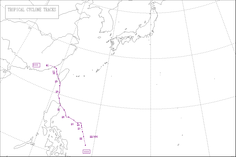
The area of low pressure that was about to become Nanmadol formed, on August 19. It drifted north and became a tropical depression on August 21, a tropical storm on August 23 and a typhoon on the same night. Nanmadol reached peak strength with winds of 105 knots (194 km/h; 121 mph) (10-minute sustained) and 135 knots (250 km/h; 155 mph) (1-minute sustained) threatening the Philippines
Philippines
The Philippines , officially known as the Republic of the Philippines , is a country in Southeast Asia in the western Pacific Ocean. To its north across the Luzon Strait lies Taiwan. West across the South China Sea sits Vietnam...
with heavy rain and flash flooding. The Filipinos were warned about high waves, strong winds and very heavy rains over the weekend with storm signal 4 raised in parts of the Nation. There, strong winds toppled trees, power and communication lines triggering power outages in the provinces of Cagayan
Cagayan
Cagayan , the "Land of Smiling Beauty", is a province of the Philippines in the Cagayan Valley region in Luzon. Its capital is Tuguegarao City and is located at the northeastern corner of the island of Luzon. Cagayan also includes the Babuyan Islands to the north. The province borders Ilocos Norte...
and Isabela
Isabela
-Places:* Isabela, Puerto Rico* Isabela Island of the Galápagos Islands* La Isabela in the Dominican Republic, first settlement of Columbus in the New World* Isabela , Philippines* Isabela City, Basilan, Philippines...
. Rivers swelled up on receiving tons on rainwater, overflowing at least six bridges across the two provinces. The typhoon hardly moved in 24 hours bringing relentless rain
Rain
Rain is liquid precipitation, as opposed to non-liquid kinds of precipitation such as snow, hail and sleet. Rain requires the presence of a thick layer of the atmosphere to have temperatures above the melting point of water near and above the Earth's surface...
s to the archipelago causing the retaining wall of Baguio's dump facility to collapse. Also, major power lines in the nation were pulled down causing total power failures in Benguet
Benguet
Benguet is a landlocked province of the Philippines in the Cordillera Administrative Region in Luzon. Its capital is La Trinidad and borders, clockwise from the south, Pangasinan, La Union, Ilocos Sur, Mountain Province, Ifugao, and Nueva Vizcaya....
, Cagayan
Cagayan
Cagayan , the "Land of Smiling Beauty", is a province of the Philippines in the Cagayan Valley region in Luzon. Its capital is Tuguegarao City and is located at the northeastern corner of the island of Luzon. Cagayan also includes the Babuyan Islands to the north. The province borders Ilocos Norte...
, Apayao
Apayao
Apayao is a landlocked province of the Philippines in the Cordillera Administrative Region in Luzon. Its administrative capital is Luna and founding capital Kabugao. It borders Cagayan to the north and east, Abra and Ilocos Norte to the west, and Kalinga to the south...
, Kalinga
Kalinga
Kalinga is a landlocked province of the Philippines in the Cordillera Administrative Region in Luzon. Its capital is Tabuk and borders Mountain Province to the south, Abra to the west, Isabela to the east, Cagayan to the northeast, and Apayao to the north...
and Mountain Provinces.
In Taiwan
Taiwan
Taiwan , also known, especially in the past, as Formosa , is the largest island of the same-named island group of East Asia in the western Pacific Ocean and located off the southeastern coast of mainland China. The island forms over 99% of the current territory of the Republic of China following...
, the Central Weather Bureau issued a sea warnings instructing all ships passing through the Bashi Channel to stay updated about the typhoon. The president of Taiwan ordered evacuations of thousands of people from vulnerable areas, saying that a slow moving typhoon could result in more damages and casualties than normal. Some 35,000 soldiers were ordered to be ready to help out as many people as possible when the typhoon strikes. The soldiers were in possession of portable power generators, water pumps and amphibious assault vehicles. The Taiwan Railway Administration
Taiwan Railway Administration
The Taiwan Railway Administration is an agency of the Ministry of Transportation and Communications of the Republic of China responsible for managing, maintaining, and running passenger and freight service on 1097 km of conventional railroad lines in Taiwan...
halted services on the South-Link Line in fear that heavy rain could trigger landslides and cause rail-accidents. The Directorate-General of Highway
Highway
A highway is any public road. In American English, the term is common and almost always designates major roads. In British English, the term designates any road open to the public. Any interconnected set of highways can be variously referred to as a "highway system", a "highway network", or a...
s closed the Suhua Highway saying that the area through which the highway was built is more prone to landslides during typhoons. After landfall, Nanmadol dumped very heavy rainfall over the nation. Some 528 millimetres (20.8 in) of rain was dumped in Hualien County; 517 millimetres (20.4 in) in Hengchun, Pingtung County; 449 millimetres (17.7 in) in Taitung County; 292 millimetres (11.5 in) in Pinglin, New Taipei; 275 millimetres (10.8 in) in Kaohsiung; and 265 millimetres (10.4 in) in Taiping Mountain, Yilan County. The Council of Agriculture soon issued a red-alert for six riverside areas advising people that are at a high risk of mudslides after heavy torrential rains dumped by the typhoon. Even long after Nanmadol left Taiwan, heavy rain continued to batter the nation. Several parts of the nation saw rains of more than on meter and 1.5 meters with Pingtung County
Pingtung County
Pingtung County is a county in Southern Taiwan. Pingtung County is officially administered as a county of the Republic of China . The oldest national park in Taiwan, Kenting National Park, was established in Pingtung County in 1984...
was the hardest hit of all.
In China
Mainland China
Mainland China, the Chinese mainland or simply the mainland, is a geopolitical term that refers to the area under the jurisdiction of the People's Republic of China . According to the Taipei-based Mainland Affairs Council, the term excludes the PRC Special Administrative Regions of Hong Kong and...
, Local authorities started calling back several thousands of ships informing them about the heavy rain the typhoon was pouring. The storm was expected to bring heavy torrential rains and flash flooding as is makes landfall on the southern part of Fujian province. Bullet train
Bullet train
Bullet train may refer to:* The Shinkansen high speed trains of Japan, so nicknamed for their appearance and speed* Other high speed trains of a similar appearance to the original Japanese trains...
s along the Wenzhou-Fuzhou and Fuzhou-Xiamen high speed rail lines were ordered to either operate slowly or suspend services completely if the surveillance system detects any hazards. Also, the shipping route linking Xiamen, in east China's Fujian Province, and Jinmen, in Taiwan was closed at 14:00 local time as the storm entered the strait. Nanmadol made landfall as a weak tropical cyclone bringing heavy rains, prompting local authorities to issue flood and landslide warnings. Thousands of fishermen's livelihoods were at risks of being washed away. Evacuations were being carried out with local residents being taken to higher grounds.
Meteorological history
Late on August 19, an area of low pressure developed north of PalauPalau
Palau , officially the Republic of Palau , is an island nation in the Pacific Ocean, east of the Philippines and south of Tokyo. In 1978, after three decades as being part of the United Nations trusteeship, Palau chose independence instead of becoming part of the Federated States of Micronesia, a...
. Early on August 20, the system became more organized and developed a low-level circulation center
Eye (cyclone)
The eye is a region of mostly calm weather found at the center of strong tropical cyclones. The eye of a storm is a roughly circular area and typically 30–65 km in diameter. It is surrounded by the eyewall, a ring of towering thunderstorms where the second most severe weather of a cyclone...
. The system then turned north and continued to drift north until on August 21, when the Japan Meteorological Agency
Japan Meteorological Agency
The or JMA, is the Japanese government's weather service. Charged with gathering and reporting weather data and forecasts in Japan, it is a semi-autonomous part of the Ministry of Land, Infrastructure and Transport...
(JMA) upgraded the low pressure area to a tropical depression east of Philippines
Philippines
The Philippines , officially known as the Republic of the Philippines , is a country in Southeast Asia in the western Pacific Ocean. To its north across the Luzon Strait lies Taiwan. West across the South China Sea sits Vietnam...
. The Joint Typhoon Warning Center
Joint Typhoon Warning Center
The Joint Typhoon Warning Center is a joint United States Navy – United States Air Force task force located at the Naval Maritime Forecast Center in Pearl Harbor, Hawaii...
(JTWC) also issued a Tropical Cyclone Formation Alert
Tropical Cyclone Formation Alert
A Tropical Cyclone Formation Alert is a bulletin released by the U.S. Navy-operated Joint Typhoon Warning Center in Honolulu, Hawaii or the Naval Maritime Forecast Center in Norfolk, Virginia, warning of the possibility of a tropical cyclone forming from a tropical disturbance that has been...
(TCFA) on the system reporting that the system was becoming more well organized. Later that day, the Philippine Atmospheric, Geophysical and Astronomical Services Administration
Philippine Atmospheric, Geophysical and Astronomical Services Administration
The Philippine Atmospheric, Geophysical and Astronomical Services Administration is a Philippine national institution dedicated to provide flood and typhoon warnings, public weather forecasts and advisories, meteorological, astronomical, climatological, and other specialized information and...
(PAGASA) started monitoring the system as a tropical depression and named it Mina. Late on August 22, the system became more well organized prompting the JTWC to initiate advisories on the system, designating it with 14W.
On August 23, the JMA upgraded 14W to a tropical storm, naming it Nanmadol. Overnight, the system continued to intensify and early on August 24, the JMA upgraded Nanmadol to a severe tropical storm. Later that day, convective banding improved and Nanmadol developed an eye-like feature. As a result, Nanmadol continued to intensify rapidly and became a typhoon, by midnight, that day. The JTWC originally anticipated a fujiwhara effect
Fujiwhara effect
The Fujiwhara effect or Fujiwara interaction, named after Sakuhei Fujiwhara, is a type of interaction between two nearby cyclonic vortices, causing them to appear to "orbit" each other.-Description:...
of Nanmadol on Talas, a weaker tropical cyclone to the east of Nanmadol. However, the two cyclones moved far away from each other with at-least a 1000 nautical miles (1,852 km) of distance between them. This prompted the JTWC to change its forecast on the system, from turning east and interacting with Talas, to move west and hit the Philippines. On August 26, Nanmadol reached peak strength with winds of 105 knots (57.2 m/s) (10-minute sustained) and 135 knots (73.5 m/s) (1-minute sustained) reaching almost category 5 status on the SSHS. The typhoon developed a large eye with a diameter of 18 nautical miles (33.3 km) with highly symmetric deep convective bands wrapped into it.
Nanmadol continued to drift north west and made landfall over Gonzaga, Cagayan
Gonzaga, Cagayan
Gonzaga is a 1st class municipality in the province of Cagayan, Philippines.-Physical description:Gonzaga is located at the northeastern tip of the province of Cagayan, bordered by the municipality of Santa Ana to the northeast, the municipality of Santa Teresita to the west, and the municipality...
, Philippines
Philippines
The Philippines , officially known as the Republic of the Philippines , is a country in Southeast Asia in the western Pacific Ocean. To its north across the Luzon Strait lies Taiwan. West across the South China Sea sits Vietnam...
with strong winds of over 95 knots (51.7 m/s). After interacting with land, the eye of Nanmadol became cloud filled and the eyewall in the northern semicircle became eroded causing the system to weaken. However, the typhoon maintained tightly curved convective banding and central convection
Atmospheric convection
Atmospheric convection is the result of a parcel-environment instability, or temperature difference, layer in the atmosphere. Different lapse rates within dry and moist air lead to instability. Mixing of air during the day which expands the height of the planetary boundary layer leads to...
for long time after the landfall. The typhoon maintained a favorable upper level outflow
Outflow (meteorology)
Outflow, in meteorology, is air that flows outwards from a storm system. It is associated with ridging, or anticyclonic flow. In the low levels of the troposphere, outflow radiates from thunderstorms in the form of a wedge of rain-cooled air, which is visible as a thin rope-like cloud on weather...
, though located in a mid-level subtropical ridge
Subtropical ridge
The subtropical ridge is a significant belt of high pressure situated around the latitudes of 30°N in the Northern Hemisphere and 30°S in the Southern Hemisphere. It is characterized by mostly calm winds, which acts to reduce air quality under its axis by causing fog overnight, and haze during...
. As Nanmadol started moving away from Luzon, the eye became more evident and central convection became re-consolidated with curved banding. However, the typhoon did not maintain this for long. Nanmadol could not recover very well from interacting with land and started weakening as the cloud tops were warming up and the eye was being filled with clouds again. During the early hours of August 28, Nanmadol struggled to strengthen after passing over the Babuyan Islands
Babuyan Islands
The Babuyan Islands form an archipelago located in the Luzon Strait north of Luzon island in the Philippines. It is separated from Luzon by the Babuyan Channel and from the Batanes Islands to its north by the Balintang Channel....
. The eye became completely cloud-filled and the outermost rainbands crossed over Taiwan
Taiwan
Taiwan , also known, especially in the past, as Formosa , is the largest island of the same-named island group of East Asia in the western Pacific Ocean and located off the southeastern coast of mainland China. The island forms over 99% of the current territory of the Republic of China following...
. This prompted the JMA to downgrade Nanmadol to a severe tropical storm. Later that day, the central convection started depleting as the system approached southern Taiwan. At that time, it was located approximately 245 nautical miles (453.7 km) south of Taipei
Taipei
Taipei City is the capital of the Republic of China and the central city of the largest metropolitan area of Taiwan. Situated at the northern tip of the island, Taipei is located on the Tamsui River, and is about 25 km southwest of Keelung, its port on the Pacific Ocean...
in the periphery of a mid-level subtropical ridge. Nanmadol continued to weaken as it approached Taiwan and the winds rapidly decreased to under 75 knots (40.8 m/s) (1-minute sustained), making Nanmadol a minimal typhoon on the SSHS. It maintained a poorly defined eyewall to its south with convective banding wrapped into the cloud filled center.
Late on August 28, Nanmadol made its second landfall over Taimali Township
Taimali, Taitung
Taimali is a township in Taitung County, Taiwan, has a population of 12,116 in 96.6523km2 area. Taimali Township is located on the coastline and facing Pacific Ocean.-History:...
in Taitung County
Taitung County
Taitung County is a county in eastern Taiwan. The name means "Eastern Taiwan". Taitung County is also known as 後山 by many of the locals, meaning behind the mountains or the back mountains. Taitung is officially administered as a county of Taiwan, Republic of China.Taitung runs along the south east...
, Taiwan
Taiwan
Taiwan , also known, especially in the past, as Formosa , is the largest island of the same-named island group of East Asia in the western Pacific Ocean and located off the southeastern coast of mainland China. The island forms over 99% of the current territory of the Republic of China following...
and started weakening. After a tremendous burst of convection over southern Taiwan, land interaction severely weakened the system. A strong subtropical ridge towards the north-east of the storm started pushing Nanmadol towards the northwest at an increasingly fast pace. Soon, Nanmadol accelerated towards the northwest and entered the Taiwan Strait
Taiwan Strait
The Taiwan Strait or Formosa Strait, formerly known as the Black Ditch, is a 180-km-wide strait separating Mainland China and Taiwan. The strait is part of the South China Sea and connects to East China Sea to the northeast...
, with fragmented convective bands wrapped into an adequately defined center. Landfall weakened the system rapidly prompting the JTWC to downgrade Nanmadol to a tropical storm with winds of under 50 knots (27.2 m/s). Eventually, the JMA too downgraded Nanmadol to a tropical storm with winds of under 45 knots (24.5 m/s). At that time, it was located to the west of Tainan
Tainan
Tainan City is a city in southern Taiwan. It is the fifth largest after New Taipei, Kaohsiung, Taichung, and Taipei. It was formerly a provincial city, and in 2010, the provincial city merged with the adjacent Tainan County to form a single special municipality. Tainan faces the Taiwan Strait in...
, Taiwan
Taiwan
Taiwan , also known, especially in the past, as Formosa , is the largest island of the same-named island group of East Asia in the western Pacific Ocean and located off the southeastern coast of mainland China. The island forms over 99% of the current territory of the Republic of China following...
with 30 knots (16.3 m/s) winds spreading 220 nautical miles (407.4 km) towards the north-east and 140 nautical miles (259.3 km) towards the south-west.
On August 30, Nanmadol slowed moving and became almost stationary. The low level circulation center became exposed and the curved convective banding moved to the south of the system. Soon it started experiencing strong wind shear and continued weakening. The shear pushed convection approximately 70 knots (38.1 m/s) south of the LLCC. The system also accelerated towards China at 8 knots (4.4 m/s) and weakened to a minimal tropical storm. After its third landfall over Fujian
Fujian
' , formerly romanised as Fukien or Huguing or Foukien, is a province on the southeast coast of mainland China. Fujian is bordered by Zhejiang to the north, Jiangxi to the west, and Guangdong to the south. Taiwan lies to the east, across the Taiwan Strait...
, China
People's Republic of China
China , officially the People's Republic of China , is the most populous country in the world, with over 1.3 billion citizens. Located in East Asia, the country covers approximately 9.6 million square kilometres...
, Nanmadol weakened rapidly prompting both the JTWC and the JMA to issue their final warnings on the system.
Philippines
On August 25, the residents of northern PhilippinesPhilippines
The Philippines , officially known as the Republic of the Philippines , is a country in Southeast Asia in the western Pacific Ocean. To its north across the Luzon Strait lies Taiwan. West across the South China Sea sits Vietnam...
started preparing for Nanmadol, as the Philippine government advised them about heavy rain and flash flooding after the slow moving typhoon brushes the coasts. On the next day, as the Nanmadol became dangerously strong, storm warning signal 3 was raised over Isabela, Cagayan
Cagayan
Cagayan , the "Land of Smiling Beauty", is a province of the Philippines in the Cagayan Valley region in Luzon. Its capital is Tuguegarao City and is located at the northeastern corner of the island of Luzon. Cagayan also includes the Babuyan Islands to the north. The province borders Ilocos Norte...
, Calayan, and Babuyan. Residents were warned about high waves, strong winds and very heavy rains over the weekend. Also, people living in low-lying areas were instructed to prepare for flash flooding and landslides. The Philippine Department of Health
Department of Health (Philippines)
The Philippines’ Department of Health is the principal health agency in the Philippines. It is the executive department of the Philippine Government responsible for ensuring access to basic public health services to all Filipinos through the provision of quality health care and the regulation of...
issued a white alert to its subordinates all along Nanmadol's path, ordering them to stock up on medicines and supplies so that the victims need not purchase them at the time of need.
As Nanmadol continued to intensify rapidly, storm signal was upgraded to 4 in some parts of Cagayan. Quickly, the Philippine National Police
Philippine National Police
The Philippine National Police is the national police force of the Republic of the Philippines. It is both a national and a local police force in that it does provides all law enforcement services throughout the Philippines...
were fully activated as Nanmadol intensified on nearing the north east Philippine coasts. The PNP were ordered to be in close coordination with the Armed Forces of the Philippines
Armed Forces of the Philippines
The Armed Forces of the Philippines is composed of the Philippine Army, Philippine Navy and Philippine Air Force...
and the Office of Civil Defense
Department of National Defense (Philippines)
The Department of National Defense is the executive department of the Philippine government responsible for guarding against external and internal threats to peace and security in the country...
. Also, the Philippine Atmospheric, Geophysical and Astronomical Services Administration
Philippine Atmospheric, Geophysical and Astronomical Services Administration
The Philippine Atmospheric, Geophysical and Astronomical Services Administration is a Philippine national institution dedicated to provide flood and typhoon warnings, public weather forecasts and advisories, meteorological, astronomical, climatological, and other specialized information and...
reported that though Nanmadol was intensifying rapidly, heavy rains were no longer expected. The PAGASA said that unlike Ketsana in 2009
2009 Pacific typhoon season
The 2009 Pacific typhoon season was the period that tropical cyclones formed in the Western Pacific Ocean. The season ran throughout the year during 2009, with most tropical cyclones forming between May and November. The scope of this article is limited to the Pacific Ocean, north of the equator...
, Nanmadol carried less rainwater and would dump less rain when compared to Ketsana. On August 27, several flights were cancelled as the typhoon drifted closer to Philippines unexpectedly. Several sea vessels were also warned about very rough sea conditions over the weekend.
Taiwan
On August 26, the Central Weather BureauCentral Weather Bureau
The Central Weather Bureau is the government meteorological research and forecasting institution of the Republic of China . In addition to meteorology, the Central Weather Bureau also makes astronomical observations, reports on sea conditions, and conducts research into seismology and provides...
issued a sea warning as they were no longer expecting a Fujiwhara effect
Fujiwhara effect
The Fujiwhara effect or Fujiwara interaction, named after Sakuhei Fujiwhara, is a type of interaction between two nearby cyclonic vortices, causing them to appear to "orbit" each other.-Description:...
, which could possibly pull Nanmadol away from Taiwan
Taiwan
Taiwan , also known, especially in the past, as Formosa , is the largest island of the same-named island group of East Asia in the western Pacific Ocean and located off the southeastern coast of mainland China. The island forms over 99% of the current territory of the Republic of China following...
. Nanmadol was anticipated to brush Taiwan's eastern coast. All ships passing through the Bashi Channel
Bashi Channel
The Bashi Channel is a strait between the Y'Ami Island of the Philippines and Orchid Island of Taiwan. It is characterized by windy storms during the rainy period, June to December. It is a part of the Pacific Ocean....
were warned to stay updated about the typhoon. Also, Taiwanese residents were warned about possible heavy rains and strong winds from Monday, 29 August.
On August 27, The Central Emergency Operation Center of Taiwan announced that they were completely prepared for any kind of contingencies
Effects of tropical cyclones
The main effects of tropical cyclones include heavy rain, strong wind, large storm surges at landfall, and tornadoes. The destruction from a tropical cyclone depends mainly on its intensity, its size, and its location...
triggered by the typhoon. Also, the police in Hualien set up a blockade to prevent people from approaching the seashore where high waves have been detected. Also, the residents of the Pingtung
Pingtung County
Pingtung County is a county in Southern Taiwan. Pingtung County is officially administered as a county of the Republic of China . The oldest national park in Taiwan, Kenting National Park, was established in Pingtung County in 1984...
and Taitung
Taitung County
Taitung County is a county in eastern Taiwan. The name means "Eastern Taiwan". Taitung County is also known as 後山 by many of the locals, meaning behind the mountains or the back mountains. Taitung is officially administered as a county of Taiwan, Republic of China.Taitung runs along the south east...
counties were asked to prepare for torrential downpour and strong winds. The Opposition Democratic Progressive Party
Democratic Progressive Party
The Democratic Progressive Party is a political party in Taiwan, and the dominant party in the Pan-Green Coalition. Founded in 1986, DPP is the first meaningful opposition party in Taiwan. It has traditionally been associated with strong advocacy of human rights and a distinct Taiwanese identity,...
postponed their national congress meeting for the safety of party members and to allow its workers to focus on typhoon relief work.
On August 28, Ma Ying-jeou
Ma Ying-jeou
Ma Ying-jeou is the 12th term and current President of the Republic of China , commonly known as Taiwan, and the Chairman of the Kuomintang Party, also known as the Chinese Nationalist Party. He formerly served as Justice Minister from 1993 to 1996, Mayor of Taipei from 1998 to 2006, and Chairman...
, the president of Taiwan ordered evacuations of thousands of people from vulnerable areas, saying that a slow moving typhoon could result in more damages and casualties than normal. The Defense Ministry of Taiwan mobilized some 35,000 soldiers to be ready to help out as many people as possible when the typhoon strikes. The soldiers were in possession of portable power generators, water pumps and amphibious assault vehicles.
On August 29, offices and schools were shut and a yellow alert, the second lowest in the nation's four-level rainstorm alert system was issued by the National Marine Environmental Forecasting Center. Also, the Taiwan Railway Administration
Taiwan Railway Administration
The Taiwan Railway Administration is an agency of the Ministry of Transportation and Communications of the Republic of China responsible for managing, maintaining, and running passenger and freight service on 1097 km of conventional railroad lines in Taiwan...
halted services on the South-Link Line
South-Link Line
The South-Link Line is a line of the Taiwan Railway Administration running along the south end of the island of Taiwan, connecting the eastern and western coasts. It is 98.2 km long, of which 81.4 km is single track...
in fear that heavy rain could trigger landslides and cause rail-accidents. The Directorate-General of Highways
Highway System in Taiwan
Highways in the Republic of China are classified into four types:# National highways: 1 - 10 # Provincial highways: 1 - 39, 61 - 88 # County routes: 101 - 205# Township routes-The numbering system:...
closed the Suhua Highway
Suhua Highway
Suhua Highway is a 118-kilometre section of the Provincial Highway No. 9 in Taiwan, starting at Su-ao Township, Yilan and ending at Hualien City, Hualien. With a portion built alongside very steep cliffs high above the Pacific Ocean, it is a dangerous yet scenic drive...
saying that the area through which the highway was built is more prone to landslides during typhoons.
China
After Nanmadol left the island nation of Taiwan and entered the Taiwan StraitTaiwan Strait
The Taiwan Strait or Formosa Strait, formerly known as the Black Ditch, is a 180-km-wide strait separating Mainland China and Taiwan. The strait is part of the South China Sea and connects to East China Sea to the northeast...
, Local authorities started calling back several thousands of ships informing them about the heavy rain the typhoon was pouring. The Maritime affairs bureaus of Fuzhou
Fuzhou
Fuzhou is the capital and one of the largest cities in Fujian Province, People's Republic of China. Along with the many counties of Ningde, those of Fuzhou are considered to constitute the Mindong linguistic and cultural area....
, Putian
Putian
Putian is a prefecture-level city in eastern Fujian province, People's Republic of China. It borders Fuzhou City to the north, Quanzhou City to the south, and the Taiwan Strait to the east.-Administration:...
, Quanzhou
Quanzhou
Quanzhou is a prefecture-level city in Fujian province, People's Republic of China. It borders all other prefecture-level cities in Fujian but two and faces the Taiwan Strait...
, Xiamen
Xiamen
Xiamen , also known as Amoy , is a major city on the southeast coast of the People's Republic of China. It is administered as a sub-provincial city of Fujian province with an area of and population of 3.53 million...
and Zhangzhou
Zhangzhou
Zhangzhou is a prefecture-level city in southern Fujian province, People's Republic of China. Located on the banks of the Jiulong River , Zhangzhou borders the cities of Xiamen and Quanzhou to the northeast, Longyan City to the northwest and the province of Guangdong to the southwest.Zhangzhou...
cities activated the red warning, the highest level on the Chinese scale, ordering all ships to return to the harbor as soon as possible. The storm was expected to bring heavy torrential rains and flash flooding as is makes landfall on the southern part of Fujian
Fujian
' , formerly romanised as Fukien or Huguing or Foukien, is a province on the southeast coast of mainland China. Fujian is bordered by Zhejiang to the north, Jiangxi to the west, and Guangdong to the south. Taiwan lies to the east, across the Taiwan Strait...
province. For safety insurance, bullet trains along the Wenzhou-Fuzhou
Wenzhou–Fuzhou Railway
The Wenzhou–Fuzhou Railway is a dual-track, electrified, high-speed rail line on the eastern coast of China. The line, also known as the Wenfu Railway, is named after its two terminal cities Wenzhou in Zhejiang Province and Fuzhou in Fujian Province. The line has a total length of 298.4...
and Fuzhou-Xiamen
Fuzhou–Xiamen Railway
The Fuzhou–Xiamen Railway is a dual-track, electrified, high-speed rail line in eastern China. The line, also known as the Fuxia Railway, is named after its two terminal cities Fuzhou and Xiamen, both coastal cities in Fujian Province. The line has a total length of 274.9 kilometres and forms...
high speed rail lines were ordered to either operate slowly or suspend services completely if the surveillance system detects any hazards. Also, the shipping route linking Xiamen
Xiamen
Xiamen , also known as Amoy , is a major city on the southeast coast of the People's Republic of China. It is administered as a sub-provincial city of Fujian province with an area of and population of 3.53 million...
, in east China's Fujian Province, and Jinmen, in Taiwan was closed at 14:00 local time as the storm entered the strait. The seawalls originally built to resist Nanmadol's strong storm surge
Storm surge
A storm surge is an offshore rise of water associated with a low pressure weather system, typically tropical cyclones and strong extratropical cyclones. Storm surges are caused primarily by high winds pushing on the ocean's surface. The wind causes the water to pile up higher than the ordinary sea...
were discovered with several cracks, each measuring two meters in length along Jinjiang
Jinjiang
Jinjiang City is a county-level city of Quanzhou Municipality in Fujian. It is located in the southeastern part of the province, on the right or south bank of the Jin River, across from Quanzhou's urban district of Fengze...
's coast in the village of Weitou.
Impact
| Country | Casualties | Damage (USD) | ||
|---|---|---|---|---|
| Deaths | Injuries | Missing | ||
| Philippines | 35 | 37 | 8 | 34,521,216 |
| Taiwan | 1 | 0 | 0 | ~500,000,000 |
| China | 2 | 20 | 6 | 68,893,194 |
| Total | 38 | 57 | 14 | 603,414,410 |
Philippines
On August 23, the system's rainbands caused heavy rains in the Philippines's Zamboanga del SurZamboanga del Sur
Zamboanga del Sur is a province of the Philippines located in the Zamboanga Peninsula region in Mindanao. Pagadian City is the capital...
province triggering a landslide. No one was reported to be dead or injured however. On August 26, the National Disaster Risk Reduction and Management Council (NDRRMC) reported that one fisherman went missing after local residents reported that they found his banca
Jukung
A jukung or canoe is a small wooden Indonesian boat. It is a traditional fishing boat, but newer uses include "Jukung Dives", using the boat as a vehicle for small groups of SCUBA divers...
empty. On that day, the typhoon spawned a tornado in the Biliran Province blowing out three school buildings. No children were reported to be dead or injured although.
On August 27, Nanmadol lashed into the northern tip of the nation bringing heavy rains, causing landslides. Nanmadol, the strongest typhoon to affect the Philippines in 2011, killed two children in a landslide and left two fishermen missing. Later, the NDRRMC started forced evacuations in some areas of the Cagayan
Cagayan
Cagayan , the "Land of Smiling Beauty", is a province of the Philippines in the Cagayan Valley region in Luzon. Its capital is Tuguegarao City and is located at the northeastern corner of the island of Luzon. Cagayan also includes the Babuyan Islands to the north. The province borders Ilocos Norte...
province after storm warning signal 4 has been raised. The typhoon's eye passed over the city of Santa Ana
Santa Ana, Cagayan
Santa Ana is a 2nd class municipality in the province of Cagayan, Philippines. According to the latest census, it has a population of 25,833 people in 4,101 households.Santa Ana is the home of the Cagayan Special Economic Zone.-Barangays:...
with the 24-hour rainfall accumulation over 400 millimetres (15.7 in). The typhoon also enhanced the Southwest Monsoonal Flow across the Philippines bringing heavy rains and squall
Squall
A squall is a sudden, sharp increase in wind speed which is usually associated with active weather, such as rain showers, thunderstorms, or heavy snow. Squalls refer to an increase in the sustained winds over a short time interval, as there may be higher gusts during a squall event...
s. Another big issue was that the typhoon slowed down after landfall and did not move much in six hours, leaving the northern half of the nation in danger for a longer period of time. Some thirteen families were evacuated from the Isabela province which was earlier hit by the typhoon as the governed ordered dam officials to release water if conditions worsen at the Magat Dam
Magat Dam
Magat Dam is a large rock-fill dam on the island of Luzon in the Philippines. The dam is located on Magat River, a major tributary of Cagayan River. Construction of the dam started in 1975 and completed in 1982...
. Nanmadol's strong winds toppled trees, power and communication lines triggering power outages in the provinces of Cagayan and Isabela. Also, the system spawned another tornado which blew out some 18 houses in the Ilocos Norte
Ilocos Norte
Ilocos Norte is a province of the Philippines located in the Ilocos Region in Luzon. Its capital is Laoag City and is located at the northwest corner of Luzon Island, bordering Cagayan and Apayao to the east, and Abra and Ilocos Sur to the south...
province. Rivers swelled up on receiving tons on rainwater, overflowing at least six bridges across the two provinces. Another landslide in the Cordillera region blocked zig-zag shaped roads lying between mountains. Late on the day, the NDRRMC reported that by then, Nanmadol killed 6, injured 7 and left 6 more missing. They also added that several towns in Ilocos Norte were completely submerged by floodwater. Several roads in the provinces of Ilocos Sur
Ilocos Sur
Ilocos Sur is a province of the Philippines located in the Ilocos Region in Luzon. Vigan City, located on the mouth of the Mestizo River is the provincial capital...
, La Union
La Unión
La Union or La Unión may refer to:-Colombia:*La Unión, Antioquia*La Unión, Nariño*La Unión, Sucre*La Unión, Valle del Cauca-Peru:*La Unión Province, Peru...
and Pangasinan
Pangasinan
Pangasinan is a province of the Republic of the Philippines. The provincial capital is Lingayen. Pangasinan is located on the west central and peripheral area of the island of Luzon along the Lingayen Gulf, with the total land area being 5,368.82 square kilometers . According to the latest census,...
. The typhoon hardly moved in 24 hours bringing relentless rains to the archipelago causing the retaining wall of Baguio's dump facility to collapse. Also, major power lines in the nation were pulled down causing total power failures in Benguet
Benguet
Benguet is a landlocked province of the Philippines in the Cordillera Administrative Region in Luzon. Its capital is La Trinidad and borders, clockwise from the south, Pangasinan, La Union, Ilocos Sur, Mountain Province, Ifugao, and Nueva Vizcaya....
, Cagayan, Apayao
Apayao
Apayao is a landlocked province of the Philippines in the Cordillera Administrative Region in Luzon. Its administrative capital is Luna and founding capital Kabugao. It borders Cagayan to the north and east, Abra and Ilocos Norte to the west, and Kalinga to the south...
, Kalinga
Kalinga
Kalinga is a landlocked province of the Philippines in the Cordillera Administrative Region in Luzon. Its capital is Tabuk and borders Mountain Province to the south, Abra to the west, Isabela to the east, Cagayan to the northeast, and Apayao to the north...
and Mountain
Mountain Province
Mountain Province is a landlocked province of the Philippines in the Cordillera Administrative Region in Luzon. Its capital is Bontoc and borders, clockwise from the south, Ifugao, Benguet, Ilocos Sur, Abra, Kalinga, and Isabela.Mountain Province is sometimes incorrectly named Mountain in some...
Provinces.
On August 28, the NDRRMC reported that the typhoon displaced a total of 108,788 people, killing 7, injuring 10 and leaving 6 more missing. A Total of 93 houses were damaged including 16 totally destroyed. A total of 9 bridges and 28 roads remained impassable as floodwater rushed on top of them. Power was restored to many provinces including Isabela communication lines were functional. The only province left without power was Aurora. On August 29, the NDRRMC further upgraded the death toll to 12, the number of injured to 21 and the number of missing to 9. They added that two people from Baguio City
Baguio City
The City of Baguio is a highly urbanized city in northern Luzon in the Philippines. Baguio City was established by Americans in 1900 at the site of an Ibaloi village known as Kafagway...
and Benguet
Benguet
Benguet is a landlocked province of the Philippines in the Cordillera Administrative Region in Luzon. Its capital is La Trinidad and borders, clockwise from the south, Pangasinan, La Union, Ilocos Sur, Mountain Province, Ifugao, and Nueva Vizcaya....
were killed in landslides attributed to Nanmadol. In their report, they also mentioned that the total damage to infrastructure and agriculture caused by Nanmadol was at US$ 22,475,672. Later the same day, the NDRRMC reported that power was fine restored in Isabela province. Also, the continued to rise the death toll, putting it at 16, and the number of missing at 8. The total damage to agriculture and infrastructure was also upgraded to US$23,748,522.
On August 30, continuing the sequential reports after the typhoon, the NDRRMC pushed up the death toll to 22; the number of injured to 23 and the number of missing to 12. Also, they reported that the total number of houses damaged was 1,316 with 32 totally destroyed. The total damage to agriculture and infrastructure was also increased to US$ 26,119,801. Later the same day, the NDRRMC further upgraded the death toll to 25; the number of injured to 32 and downgraded the number of missing to 7 reporting that 5 Pangasinan fishermen were rescued.Also, they included that in the wake of Nanmadol, a total of 47 incidents including 14 flashfloods, 12 landslides, 8 tornadoes, 6 sea mishaps, 1 vehicular accident, 4 collapsed structures, 1 lightning strike and 1 soil erosion were monitored. Continuing the daily situational reports, the NDRRMC on September 1, upgraded the death toll to 29, the number of injured to
37 and downgraded the number of missing to 5. They also increased the total damage from Nanmadol to agriculture and infrastructure to US$ 33,158,317.
On September 2, the Benguet province and Baguio City were declared under State of Calamity by the NDRRMC. Also, the City Health Office Dagupan conducted a survey in their area of responsibility to check if there was any increase in flood-borne diseases. The NDRRMC confirmed more deaths, increasing the toll to 33, and the number of missing to 8 and the total cost of damage to agriculture and infrastructure to US$ 33,711,271. After thorough reanalysis, the death toll was last raised to 35 and the damage was put at US$ 34,521,216.
Taiwan
As Nanmadol made landfall over Taiwan, it dumped very heavy rainfall over the nation. Some 528 millimetres (20.8 in) of rain was dumped in Hualien CountyHualien County
Hualien County is the largest county in Taiwan and is located on the mountainous eastern coast of Taiwan. It contains the island's largest port. It is the starting point of the Hualien-Taitung Line and the terminal point of North-Link Line of TRA...
; 517 millimetres (20.4 in) in Hengchun
Hengchun
Hengchun of Pingtung County is the southernmost township in Taiwan. Hengchun is also the only urban township in the southern part of Pingtung County. Hengchun has a land area of 136.7630 square kilometers and has a population of 31,123 as of August 2009....
, Pingtung County
Pingtung County
Pingtung County is a county in Southern Taiwan. Pingtung County is officially administered as a county of the Republic of China . The oldest national park in Taiwan, Kenting National Park, was established in Pingtung County in 1984...
; 449 millimetres (17.7 in) in Taitung County
Taitung County
Taitung County is a county in eastern Taiwan. The name means "Eastern Taiwan". Taitung County is also known as 後山 by many of the locals, meaning behind the mountains or the back mountains. Taitung is officially administered as a county of Taiwan, Republic of China.Taitung runs along the south east...
; 292 millimetres (11.5 in) in Pinglin, New Taipei; 275 millimetres (10.8 in) in Kaohsiung
Kaohsiung
Kaohsiung is a city located in southwestern Taiwan, facing the Taiwan Strait on the west. Kaohsiung, officially named Kaohsiung City, is divided into thirty-eight districts. The city is one of five special municipalities of the Republic of China...
; and 265 millimetres (10.4 in) in Taiping Mountain
Taiping Mountain
Taiping Mountain or Taipingshan is located Datong Township in northern Taiwan's Yilan County. It is one of Taiwan's three major forest recreation areas. At 1,950 meters above sea level, Taiping Mountain has nurtured an environment rich in ecological resources.-Notes:...
, Yilan County. The heavy torrential rains soon triggered knee-high flooding across several locations in thew nation. Several thousands of people were evacuated as a precaution, when Nanmadol, the first typhoon to directly impact Taiwan since Typhoon Fanapi in 2010
2010 Pacific typhoon season
The 2010 Pacific typhoon season was the least active Pacific typhoon season, in terms of the number of named storms and typhoons, on record, due to a moderate La Niña event...
made landfall. The Council of Agriculture soon issued a red-alert for six riverside areas advising people that are at a high risk of mudslides after heavy torrential rains dumped by the typhoon. The early damage estimates to agriculture was reported to be at US$344,790 with bananas hit the hardest sustaining losses of more than NT$3 million. The storm started claiming lives later that day, when debris attributed to the storm hit a motorcyclist killing him almost instantly. Some 30,000 households in southern and eastern Taiwan did not have electricity, 8,000 people were evacuated and several roads and bridges were closed due to the heavy rain.
Even long after Nanmadol left Taiwan, heavy rain continued to batter the nation. Several parts of the nation saw rains of more than
on meter and 1.5 meters with Pingtung County
Pingtung County
Pingtung County is a county in Southern Taiwan. Pingtung County is officially administered as a county of the Republic of China . The oldest national park in Taiwan, Kenting National Park, was established in Pingtung County in 1984...
was the hardest hit of all. The total economic losses to the nation were put at NT$75.5 million (US$2.6 million). The Hengchun Township was completely inundated by the floodwaters after heavy torrential rain from Nanmadol. The rain was so heavy that a local said, "I never saw so much water in all my 60 years". On August 30, Eqecat reported that the total insured economic losses caused by Nanmaol in Taiwan could exceed US$ 500 million.
China
Nanmadol made landfall in China as a weak tropical cyclone bringing heavy rains, prompting local authorities to issue flood and landslide warnings. Also, a female news reporter in China literally escaped death after a high wave rose behind her during a live report. Thousands of fishermen's livelihoods were at risks of being washed away. Evacuations were being carried out with local residents being taken to higher grounds. On August 31, authorities in China reported that the total economic losses caused by Nanmadol in China were more than 44 million yuan (6.9 million U.S. dollars) as the storm destroyed 110 houses having more than 138,000 people evacuated. In PutianPutian
Putian is a prefecture-level city in eastern Fujian province, People's Republic of China. It borders Fuzhou City to the north, Quanzhou City to the south, and the Taiwan Strait to the east.-Administration:...
City, Nanmadol claimed two lives, leaving four missing after very heavy torrential rains attributed to the storm. Bullet trains were slowed or stopped after the heavy damaged caused by Nanmadol's remnants to Fujian Province. Also, the astronomical high tide
Tide
Tides are the rise and fall of sea levels caused by the combined effects of the gravitational forces exerted by the moon and the sun and the rotation of the Earth....
coincided with Nanmadol's storm surge
Storm surge
A storm surge is an offshore rise of water associated with a low pressure weather system, typically tropical cyclones and strong extratropical cyclones. Storm surges are caused primarily by high winds pushing on the ocean's surface. The wind causes the water to pile up higher than the ordinary sea...
bringing unusually high tides which resulted in the increase of the likelihood of coastal flooding.
On September 1, Chinese state owned news agency Xinhua reported that The storm has caused direct economic loss of 130 million yuan or US$ 20,354,807 with two deaths, twenty injuries and six missing in the Fujian Province. In Zhejiang Province, the torrential rains disrupted the lives of 65,600 people, with 160 houses were toppled and 4,600 hectares of crops destroyed, causing a direct economic loss of 310 million yuan or US$ 48,538,387.
Taiwan
On August 31, President Ma Ying-jeou visited Pingtung County, the worst hit county to check up on evacuated victims. Unlike Morakot in 20092009 Pacific typhoon season
The 2009 Pacific typhoon season was the period that tropical cyclones formed in the Western Pacific Ocean. The season ran throughout the year during 2009, with most tropical cyclones forming between May and November. The scope of this article is limited to the Pacific Ocean, north of the equator...
, Nanmadol was very well forecasted and thousands of lives were saved.
Retirement
Due to extremely high amount of damage that the storm has caused in the Philippines, the PAGASA announced that the name Mina would be stricken off their tropical cyclone Naming lists. No replacement name has been chosen yet.See also
- 2011 Pacific typhoon season2011 Pacific typhoon seasonThe 2011 Pacific typhoon season was the time of the year in which tropical cyclones form in the Western Pacific Ocean. The season ran throughout 2011 with most tropical cyclones forming between May and November. The scope of this article is limited to the Pacific Ocean to the north of the equator...
- Typhoon Muifa (2011)Typhoon Muifa (2011)Typhoon Muifa was a large, strong and persistent typhoon that affected multiple countries in the Pacific, killing 22 and causing widespread damage worth US$480 million...
- Typhoon Morakot
- Typhoon Fanapi
External links
- The JMA's Best Track Data on Typhoon Nanmadol (1111)
- The JMA's RSMC Best Track Data (Graphics) on Typhoon Nanmadol (1111)
- The JMA's RSMC Best Track Data (Text)