
.gif)
Tropical Storm Beryl (2006)
Encyclopedia
Tropical Storm Beryl was the third tropical storm
of the 2006 Atlantic hurricane season
. Developing from a tropical disturbance on July 18, it tracked generally northward, and strengthened to attain peak winds of 60 mph (95 km/h) under generally favorable conditions. After turning to the northeast, Beryl weakened over cooler waters. On July 21 it struck the island of Nantucket, and shortly thereafter it became extratropical. The extratropical remnants continued northeastward through Nova Scotia
, and on July 22 it merged with an approaching cold front.
Beryl produced rough seas along the northeast United States coastline. In Massachusetts
, its impact was limited to light rainfall and gusty winds, with no reported damage. Beryl later produced moderate rainfall and gusty winds across Atlantic Canada, resulting in some localized power outages though little damage. No deaths were reported.
moved off the East Coast of the United States
on July 16 and stalled off the coast of North Carolina
. It gradually decayed into a surface low pressure
trough
, and developed into two disturbances; one was centered 290 miles (490 km) south-southeast of Cape Cod
and another was located 200 miles (320 km) south of Cape Hatteras, North Carolina. The first low quickly organized into an unnamed tropical storm
, and the other area initially remained broad and ill-defined. However, by July 18, the system became much better organized with improved banding features, and the area developed into Tropical Depression Two while located 220 miles (355 km) south-southeast of Cape Hatteras
.
 The depression moved slowly to the north-northwest through a break in the subtropical ridge
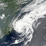
, and as convective banding features became more prominent the system intensified into Tropical Storm Beryl. Throughout much of its duration, the storm tracked through an environment with light vertical wind shear
and well-established upper-level outflow. Shortly after becoming a tropical storm, the low-level circulation of Beryl became exposed with limited deep convection, though deep convection re-developed the following morning. Outflow continued to improve, and with warm sea surface temperatures Beryl gradually intensified to attain peak winds of 60 mph (95 km/h) early on July 20 while located about 120 miles (190 km) east of Nags Head, North Carolina
.
Beryl maintained peak winds for about 18 hours as it paralleled the Mid-Atlantic
and New Jersey
coasts, during which an eye-like
feature developed in the center of the convection. Late on July 20, it began a slow weakening trend after passing over cooler waters. Steering winds ahead of an approaching mid-level trough
caused Beryl to accelerate northeastward, and early on July 21 the center of the storm crossed the island of Nantucket. The convection diminished as it moved through progressively colder waters, and shortly after 1200 UTC on July 21 Beryl became an extratropical cyclone
a short distance east of Cape Cod
. Hours later, it made landfall
in southwestern Nova Scotia
, and on July 22 the extratropical remnants of Beryl merged with an approaching cold front over Newfoundland.
from Cape Lookout northward to Currituck Beach Lighthouse. When a more northeastward track became apparent, a tropical storm watch was issued about 33 hours prior to moving ashore from Woods Hole
to Plymouth, Massachusetts, including Cape Cod
, Nantucket, and Martha's Vineyard
. About 22 hours before landfall, the National Hurricane Center replaced the watch with a tropical storm warning for the same area, and also issued a tropical storm watch from Woods Hole, Massachusetts westward to New Haven, Connecticut
and for the eastern portion of Long Island
from east of Fire Island
to Port Jefferson
. In anticipation for the storm, the Massachusetts Emergency Management Agency was activated as a trial run for the hurricane season. Local Red Cross
chapters were opened, as well, with two volunteer teams placed on standby to assist. Across southeastern Massachusetts, police departments maintained extra staff in preparation for any potential problems from the storm. Many fishermen secured their boats, while some business owners boarded up windows to prevent storm damage.
Several days prior to the passage of Beryl through Atlantic Canada
, the Canadian Hurricane Centre
issued gale warnings for the coastal waters off Nova Scotia
and Newfoundland. In anticipation of heavy rainfall, the agency also issued heavy rainfall warnings for western Nova Scotia, including Halifax
.
, with 19-foot seas (5.97 m) in the open ocean. Waves along the southern coast of Nantucket reached 10 feet (3 m) in height as the storm approached the island, resulting in four people being rescued by lifeguards from rip currents.
High surf also occurred along the southern coast of Massachusetts
, prompting the closing of the ferry between Nantucket and Boston. Beryl produced a storm surge
of 0.9 feet (.27 m) on Nantucket. Winds across southeastern Massachusetts were fairly light, with no sustained tropical storm force winds and wind gusts peaking at 44 mph (71 km/h); unofficially gusts reached 51 mph (82 km/h). Beryl dropped moderate precipitation just offshore, though the maximum precipitation total in the United States was only 0.97 inches (24.6 mm) on Nantucket. Rainfall along southeastern Massachusetts reached 0.33 inches (8.38 mm) at Chatham
. The only reported damage were some downed telephone poles and fallen tree branches. Overall impact was minor; there were no reported power outages, deaths, injuries, or maritime emergencies in association with the storm.
The remnants of Beryl dropped moderate precipitation in Atlantic Canada, officially peaking at 2.8 inches (71 mm) in Scots Bay, Nova Scotia with an unofficially higher total of 3.5 inches (88 mm); in some locations 1 inch of rain fell in an hour. Additionally, a station in Fredericton, New Brunswick
reported 1.77 inches (45 mm) in two hours. The rainfall caused some flooding, with some overflown streams flooding some streets. Moderate winds were reported along its path, which peaked at 60 mph (96 km/h) in southern Nova Scotia. The winds downed some tree limbs and led to some power outages. Overall damage was minor.
Tropical cyclone
A tropical cyclone is a storm system characterized by a large low-pressure center and numerous thunderstorms that produce strong winds and heavy rain. Tropical cyclones strengthen when water evaporated from the ocean is released as the saturated air rises, resulting in condensation of water vapor...
of the 2006 Atlantic hurricane season
2006 Atlantic hurricane season
The 2006 Atlantic hurricane season was significantly less active than the record previous season. It marked the first since 2001 in which no hurricanes made landfall in the United States, and was the first since 1994 that no tropical cyclones formed during October. Following the intense activity of...
. Developing from a tropical disturbance on July 18, it tracked generally northward, and strengthened to attain peak winds of 60 mph (95 km/h) under generally favorable conditions. After turning to the northeast, Beryl weakened over cooler waters. On July 21 it struck the island of Nantucket, and shortly thereafter it became extratropical. The extratropical remnants continued northeastward through Nova Scotia
Nova Scotia
Nova Scotia is one of Canada's three Maritime provinces and is the most populous province in Atlantic Canada. The name of the province is Latin for "New Scotland," but "Nova Scotia" is the recognized, English-language name of the province. The provincial capital is Halifax. Nova Scotia is the...
, and on July 22 it merged with an approaching cold front.
Beryl produced rough seas along the northeast United States coastline. In Massachusetts
Massachusetts
The Commonwealth of Massachusetts is a state in the New England region of the northeastern United States of America. It is bordered by Rhode Island and Connecticut to the south, New York to the west, and Vermont and New Hampshire to the north; at its east lies the Atlantic Ocean. As of the 2010...
, its impact was limited to light rainfall and gusty winds, with no reported damage. Beryl later produced moderate rainfall and gusty winds across Atlantic Canada, resulting in some localized power outages though little damage. No deaths were reported.
Meteorological history
A cold frontCold front
A cold front is defined as the leading edge of a cooler mass of air, replacing a warmer mass of air.-Development of cold front:The cooler and denser air wedges under the less-dense warmer air, lifting it...
moved off the East Coast of the United States
East Coast of the United States
The East Coast of the United States, also known as the Eastern Seaboard, refers to the easternmost coastal states in the United States, which touch the Atlantic Ocean and stretch up to Canada. The term includes the U.S...
on July 16 and stalled off the coast of North Carolina
North Carolina
North Carolina is a state located in the southeastern United States. The state borders South Carolina and Georgia to the south, Tennessee to the west and Virginia to the north. North Carolina contains 100 counties. Its capital is Raleigh, and its largest city is Charlotte...
. It gradually decayed into a surface low pressure
Low pressure area
A low-pressure area, or "low", is a region where the atmospheric pressure at sea level is below that of surrounding locations. Low-pressure systems form under areas of wind divergence which occur in upper levels of the troposphere. The formation process of a low-pressure area is known as...
trough
Trough (meteorology)
A trough is an elongated region of relatively low atmospheric pressure, often associated with fronts.Unlike fronts, there is not a universal symbol for a trough on a weather chart. The weather charts in some countries or regions mark troughs by a line. In the United States, a trough may be marked...
, and developed into two disturbances; one was centered 290 miles (490 km) south-southeast of Cape Cod
Cape Cod
Cape Cod, often referred to locally as simply the Cape, is a cape in the easternmost portion of the state of Massachusetts, in the Northeastern United States...
and another was located 200 miles (320 km) south of Cape Hatteras, North Carolina. The first low quickly organized into an unnamed tropical storm
Unnamed Tropical Storm (2006)
The 2006 Nova Scotia tropical storm was a short-lived tropical cyclone that was unnamed operationally during the season but was recognized during post-season analysis and designated AL022006...
, and the other area initially remained broad and ill-defined. However, by July 18, the system became much better organized with improved banding features, and the area developed into Tropical Depression Two while located 220 miles (355 km) south-southeast of Cape Hatteras
Cape Hatteras
Cape Hatteras is a cape on the coast of North Carolina. It is the point that protrudes the farthest to the southeast along the northeast-to-southwest line of the Atlantic coast of North America...
.
Subtropical ridge
The subtropical ridge is a significant belt of high pressure situated around the latitudes of 30°N in the Northern Hemisphere and 30°S in the Southern Hemisphere. It is characterized by mostly calm winds, which acts to reduce air quality under its axis by causing fog overnight, and haze during...
, and as convective banding features became more prominent the system intensified into Tropical Storm Beryl. Throughout much of its duration, the storm tracked through an environment with light vertical wind shear
Wind shear
Wind shear, sometimes referred to as windshear or wind gradient, is a difference in wind speed and direction over a relatively short distance in the atmosphere...
and well-established upper-level outflow. Shortly after becoming a tropical storm, the low-level circulation of Beryl became exposed with limited deep convection, though deep convection re-developed the following morning. Outflow continued to improve, and with warm sea surface temperatures Beryl gradually intensified to attain peak winds of 60 mph (95 km/h) early on July 20 while located about 120 miles (190 km) east of Nags Head, North Carolina
Nags Head, North Carolina
Nags Head is a town in Dare County, North Carolina, United States. The population was 2,700 at the 2000 census.-History:Early maps of the area show Nags Head as a promontory of land characterized by high sand dunes visible from miles at sea...
.
Beryl maintained peak winds for about 18 hours as it paralleled the Mid-Atlantic
Mid-Atlantic States
The Mid-Atlantic states, also called middle Atlantic states or simply the mid Atlantic, form a region of the United States generally located between New England and the South...
and New Jersey
New Jersey
New Jersey is a state in the Northeastern and Middle Atlantic regions of the United States. , its population was 8,791,894. It is bordered on the north and east by the state of New York, on the southeast and south by the Atlantic Ocean, on the west by Pennsylvania and on the southwest by Delaware...
coasts, during which an eye-like
Eye (cyclone)
The eye is a region of mostly calm weather found at the center of strong tropical cyclones. The eye of a storm is a roughly circular area and typically 30–65 km in diameter. It is surrounded by the eyewall, a ring of towering thunderstorms where the second most severe weather of a cyclone...
feature developed in the center of the convection. Late on July 20, it began a slow weakening trend after passing over cooler waters. Steering winds ahead of an approaching mid-level trough
Trough (meteorology)
A trough is an elongated region of relatively low atmospheric pressure, often associated with fronts.Unlike fronts, there is not a universal symbol for a trough on a weather chart. The weather charts in some countries or regions mark troughs by a line. In the United States, a trough may be marked...
caused Beryl to accelerate northeastward, and early on July 21 the center of the storm crossed the island of Nantucket. The convection diminished as it moved through progressively colder waters, and shortly after 1200 UTC on July 21 Beryl became an extratropical cyclone
Extratropical cyclone
Extratropical cyclones, sometimes called mid-latitude cyclones or wave cyclones, are a group of cyclones defined as synoptic scale low pressure weather systems that occur in the middle latitudes of the Earth having neither tropical nor polar characteristics, and are connected with fronts and...
a short distance east of Cape Cod
Cape Cod
Cape Cod, often referred to locally as simply the Cape, is a cape in the easternmost portion of the state of Massachusetts, in the Northeastern United States...
. Hours later, it made landfall
Landfall (meteorology)
Landfall is the event of a tropical cyclone or a waterspout coming onto land after being over water. When a waterspout makes landfall it is reclassified as a tornado, which can then cause damage inland...
in southwestern Nova Scotia
Nova Scotia
Nova Scotia is one of Canada's three Maritime provinces and is the most populous province in Atlantic Canada. The name of the province is Latin for "New Scotland," but "Nova Scotia" is the recognized, English-language name of the province. The provincial capital is Halifax. Nova Scotia is the...
, and on July 22 the extratropical remnants of Beryl merged with an approaching cold front over Newfoundland.
Preparations
Forecasters initially predicted Beryl to brush the Carolinas; as such, a tropical storm watch was issued for the eastern coast of North CarolinaNorth Carolina
North Carolina is a state located in the southeastern United States. The state borders South Carolina and Georgia to the south, Tennessee to the west and Virginia to the north. North Carolina contains 100 counties. Its capital is Raleigh, and its largest city is Charlotte...
from Cape Lookout northward to Currituck Beach Lighthouse. When a more northeastward track became apparent, a tropical storm watch was issued about 33 hours prior to moving ashore from Woods Hole
Woods Hole, Massachusetts
Woods Hole is a census-designated place in the town of Falmouth in Barnstable County, Massachusetts, United States. It lies at the extreme southwest corner of Cape Cod, near Martha's Vineyard and the Elizabeth Islands...
to Plymouth, Massachusetts, including Cape Cod
Cape Cod
Cape Cod, often referred to locally as simply the Cape, is a cape in the easternmost portion of the state of Massachusetts, in the Northeastern United States...
, Nantucket, and Martha's Vineyard
Martha's Vineyard
Martha's Vineyard is an island located south of Cape Cod in Massachusetts, known for being an affluent summer colony....
. About 22 hours before landfall, the National Hurricane Center replaced the watch with a tropical storm warning for the same area, and also issued a tropical storm watch from Woods Hole, Massachusetts westward to New Haven, Connecticut
New Haven, Connecticut
New Haven is the second-largest city in Connecticut and the sixth-largest in New England. According to the 2010 Census, New Haven's population increased by 5.0% between 2000 and 2010, a rate higher than that of the State of Connecticut, and higher than that of the state's five largest cities, and...
and for the eastern portion of Long Island
Long Island
Long Island is an island located in the southeast part of the U.S. state of New York, just east of Manhattan. Stretching northeast into the Atlantic Ocean, Long Island contains four counties, two of which are boroughs of New York City , and two of which are mainly suburban...
from east of Fire Island
Fire Island, New York
Fire Island is one of the outer barrier islands adjacent to the south shore of Long Island, New York. It is approximately long and varies between broad. Fire Island is part of Suffolk County. It comprises a number of hamlets, census-designated places , and villages, all of which lie within the...
to Port Jefferson
Port Jefferson, New York
The Incorporated Village of Port Jefferson is located in the town of Brookhaven in Suffolk County, New York on the North Shore of Long Island. As of the 2000 United States Census, the village population was 7,837...
. In anticipation for the storm, the Massachusetts Emergency Management Agency was activated as a trial run for the hurricane season. Local Red Cross
International Red Cross and Red Crescent Movement
The International Red Cross and Red Crescent Movement is an international humanitarian movement with approximately 97 million volunteers, members and staff worldwide which was founded to protect human life and health, to ensure respect for all human beings, and to prevent and alleviate human...
chapters were opened, as well, with two volunteer teams placed on standby to assist. Across southeastern Massachusetts, police departments maintained extra staff in preparation for any potential problems from the storm. Many fishermen secured their boats, while some business owners boarded up windows to prevent storm damage.
Several days prior to the passage of Beryl through Atlantic Canada
Atlantic Canada
Atlantic Canada is the region of Canada comprising the four provinces located on the Atlantic coast, excluding Quebec: the three Maritime provinces – New Brunswick, Prince Edward Island, and Nova Scotia – and Newfoundland and Labrador...
, the Canadian Hurricane Centre
Canadian Hurricane Centre
The Canadian Hurricane Centre is a division of the Meteorological Service of Canada, an agency of Canada's Department of the Environment, which exists to advise Canadians on the threat of tropical cyclones such as hurricanes and tropical storms...
issued gale warnings for the coastal waters off Nova Scotia
Nova Scotia
Nova Scotia is one of Canada's three Maritime provinces and is the most populous province in Atlantic Canada. The name of the province is Latin for "New Scotland," but "Nova Scotia" is the recognized, English-language name of the province. The provincial capital is Halifax. Nova Scotia is the...
and Newfoundland. In anticipation of heavy rainfall, the agency also issued heavy rainfall warnings for western Nova Scotia, including Halifax
Halifax County, Nova Scotia
Halifax County is a county in the Canadian province of Nova Scotia.The Municipality of the County of Halifax was the municipal government of Halifax County, apart from the separately incorporated towns and cities therein...
.
Impact
The storm caused high waves along the East Coast of the United StatesEast Coast of the United States
The East Coast of the United States, also known as the Eastern Seaboard, refers to the easternmost coastal states in the United States, which touch the Atlantic Ocean and stretch up to Canada. The term includes the U.S...
, with 19-foot seas (5.97 m) in the open ocean. Waves along the southern coast of Nantucket reached 10 feet (3 m) in height as the storm approached the island, resulting in four people being rescued by lifeguards from rip currents.
High surf also occurred along the southern coast of Massachusetts
Massachusetts
The Commonwealth of Massachusetts is a state in the New England region of the northeastern United States of America. It is bordered by Rhode Island and Connecticut to the south, New York to the west, and Vermont and New Hampshire to the north; at its east lies the Atlantic Ocean. As of the 2010...
, prompting the closing of the ferry between Nantucket and Boston. Beryl produced a storm surge
Storm surge
A storm surge is an offshore rise of water associated with a low pressure weather system, typically tropical cyclones and strong extratropical cyclones. Storm surges are caused primarily by high winds pushing on the ocean's surface. The wind causes the water to pile up higher than the ordinary sea...
of 0.9 feet (.27 m) on Nantucket. Winds across southeastern Massachusetts were fairly light, with no sustained tropical storm force winds and wind gusts peaking at 44 mph (71 km/h); unofficially gusts reached 51 mph (82 km/h). Beryl dropped moderate precipitation just offshore, though the maximum precipitation total in the United States was only 0.97 inches (24.6 mm) on Nantucket. Rainfall along southeastern Massachusetts reached 0.33 inches (8.38 mm) at Chatham
Chatham, Massachusetts
Chatham is a town in Barnstable County, Massachusetts, United States, Barnstable County being coextensive with Cape Cod. The population was 6,625 at the 2000 census...
. The only reported damage were some downed telephone poles and fallen tree branches. Overall impact was minor; there were no reported power outages, deaths, injuries, or maritime emergencies in association with the storm.
The remnants of Beryl dropped moderate precipitation in Atlantic Canada, officially peaking at 2.8 inches (71 mm) in Scots Bay, Nova Scotia with an unofficially higher total of 3.5 inches (88 mm); in some locations 1 inch of rain fell in an hour. Additionally, a station in Fredericton, New Brunswick
New Brunswick
New Brunswick is one of Canada's three Maritime provinces and is the only province in the federation that is constitutionally bilingual . The provincial capital is Fredericton and Saint John is the most populous city. Greater Moncton is the largest Census Metropolitan Area...
reported 1.77 inches (45 mm) in two hours. The rainfall caused some flooding, with some overflown streams flooding some streets. Moderate winds were reported along its path, which peaked at 60 mph (96 km/h) in southern Nova Scotia. The winds downed some tree limbs and led to some power outages. Overall damage was minor.
See also
- List of New England hurricanes
- Timeline of the 2006 Atlantic hurricane seasonTimeline of the 2006 Atlantic hurricane seasonThe 2006 Atlantic hurricane season was the first since 2001 in which no hurricanes made landfall in the United States, and the first since 1994 that no tropical cyclones formed during October. This timeline documents all the storm formations, strengthening, weakening, landfalls, extratropical...
- List of storms in the 2006 Atlantic hurricane season
External links
- The NHCNational Hurricane CenterThe National Hurricane Center , located at Florida International University in Miami, Florida, is the division of the National Weather Service responsible for tracking and predicting weather systems within the tropics between the Prime Meridian and the 140th meridian west poleward to the 30th...
's archive on Tropical Storm Beryl.