

Timeline of the 1990 Atlantic hurricane season
Encyclopedia
The Timeline of the 1990 Atlantic hurricane season documents all the storm formations, strengthening, weakening, landfalls
, extratropical transitions, as well as dissipation. The timeline also includes information which was not operationally released, meaning that information from post-storm reviews by the National Hurricane Center
, such as information on a storm that was not operationally warned on, has been included. The 1990 Atlantic hurricane season
was very active in terms of activity, with 16 tropical cyclones, 14 named storm, 8 hurricanes, and 1 major hurricane (hurricanes that are classified as Category 3 or higher).
 May 24
May 25
During the day, Tropical Depression One makes landfall on Cuba and attained peak intensity with winds of 30 mph and a minimum pressure of 1007 mbar (hPa; 29.74 inHg) at an unknown time.
May 26
During the day, Tropical Depression One it was absorbed by an approaching cold front at an unknown time.
July 24
July 25
July 27
July 28
July 29
.jpg) July 30
July 30
August 2
August 3
August 4
August 5
August 6
August 7
August 8
August 9
August 10
August 11
August 12
August 13
August 14
August 24
August 26
August 27
.jpg) August 28
August 28
August 30
August 31
September 2
September 3
September 5
September 6
.jpg) September 7
September 7
September 8
September 9
September 16
September 17
September 18
 September 21
September 24
September 26
September 27
October 3
October 4
 October 5
October 6
October 7
October 8
October 9
October 10
October 11
 October 12
October 13
October 14
October 15
October 16
October 17
October 19
October 20
October 21
Landfall (meteorology)
Landfall is the event of a tropical cyclone or a waterspout coming onto land after being over water. When a waterspout makes landfall it is reclassified as a tornado, which can then cause damage inland...
, extratropical transitions, as well as dissipation. The timeline also includes information which was not operationally released, meaning that information from post-storm reviews by the National Hurricane Center
National Hurricane Center
The National Hurricane Center , located at Florida International University in Miami, Florida, is the division of the National Weather Service responsible for tracking and predicting weather systems within the tropics between the Prime Meridian and the 140th meridian west poleward to the 30th...
, such as information on a storm that was not operationally warned on, has been included. The 1990 Atlantic hurricane season
1990 Atlantic hurricane season
The 1990 Atlantic hurricane season was the most active Atlantic hurricane season since 1969. It officially began on June 1, 1990, and lasted until November 30, 1990. These dates conventionally delimit the period of each year when most tropical cyclones form in the Atlantic basin...
was very active in terms of activity, with 16 tropical cyclones, 14 named storm, 8 hurricanes, and 1 major hurricane (hurricanes that are classified as Category 3 or higher).
May
- 8:00 p.m. EDT (0000 UTC May 25) - Tropical Depression One formed south of CubaCubaThe Republic of Cuba is an island nation in the Caribbean. The nation of Cuba consists of the main island of Cuba, the Isla de la Juventud, and several archipelagos. Havana is the largest city in Cuba and the country's capital. Santiago de Cuba is the second largest city...
.
May 25
During the day, Tropical Depression One makes landfall on Cuba and attained peak intensity with winds of 30 mph and a minimum pressure of 1007 mbar (hPa; 29.74 inHg) at an unknown time.
May 26
During the day, Tropical Depression One it was absorbed by an approaching cold front at an unknown time.
June
June 1- 12:00 a.m. EDTEastern Time ZoneThe Eastern Time Zone of the United States and Canada is a time zone that falls mostly along the east coast of North America. Its UTC time offset is −5 hrs during standard time and −4 hrs during daylight saving time...
(0400 UTC) - The 1990 Atlantic hurricane season1990 Atlantic hurricane seasonThe 1990 Atlantic hurricane season was the most active Atlantic hurricane season since 1969. It officially began on June 1, 1990, and lasted until November 30, 1990. These dates conventionally delimit the period of each year when most tropical cyclones form in the Atlantic basin...
officially began.
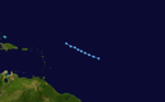
July
July 22- 2:00 a.m. EDT (0600 UTC) - Tropical Depression Two formed 1,345 miles (2,164 km) east of Port-of-Spain, TrinidadTrinidadTrinidad is the larger and more populous of the two major islands and numerous landforms which make up the island nation of Trinidad and Tobago. It is the southernmost island in the Caribbean and lies just off the northeastern coast of Venezuela. With an area of it is also the fifth largest in...
.
July 24
- 8:00 a.m. EDT (1200 UTC) - Tropical Depression Two strengthened into Tropical Storm Arthur.
- 8:00 a.m. EDT (1200 UTC) - A subtropical depression formed just offshore of North CarolinaNorth CarolinaNorth Carolina is a state located in the southeastern United States. The state borders South Carolina and Georgia to the south, Tennessee to the west and Virginia to the north. North Carolina contains 100 counties. Its capital is Raleigh, and its largest city is Charlotte...
.
July 25
- 4:00 a.m.–5:00 a.m. EDT (0800–0900 UTC) - Tropical Storm Arthur passed through the Windward IslandsWindward IslandsThe Windward Islands are the southern islands of the Lesser Antilles, within the West Indies.-Name and geography:The Windward Islands are called such because they were more windward to sailing ships arriving in the New World than the Leeward Islands, given that the prevailing trade winds in the...
between GrenadaGrenadaGrenada is an island country and Commonwealth Realm consisting of the island of Grenada and six smaller islands at the southern end of the Grenadines in the southeastern Caribbean Sea...
and TobagoTobagoTobago is the smaller of the two main islands that make up the Republic of Trinidad and Tobago. It is located in the southern Caribbean, northeast of the island of Trinidad and southeast of Grenada. The island lies outside the hurricane belt...
. - 2:00 p.m. EDT (1800 UTC) - Tropical Storm Arthur attained its peak intensity with winds of 70 mph (110 km/h) and a minimum pressure of 995 mbar (hPa; 29.38 inHg).
July 27
- 2:00 a.m. EDT (0600 UTC) - Tropical Storm Arthur weakened back to a tropical depression.
- 2:00 a.m. EDT (0600 UTC) - The subtropical depression acquired tropical characteristics and was reclassified as Tropical Depression Three.
- 2:00 p.m. EDT (1800 UTC) - Tropical Depression Arthur dissipated south of JamaicaJamaicaJamaica is an island nation of the Greater Antilles, in length, up to in width and 10,990 square kilometres in area. It is situated in the Caribbean Sea, about south of Cuba, and west of Hispaniola, the island harbouring the nation-states Haiti and the Dominican Republic...
. - 8:00 p.m. EDT (0000 UTC July 28) - Tropical Depression Three strengthened into Tropical Storm Bertha.
July 28
- 8:00 p.m. EDT (0000 UTC July 29) - Tropical Storm Bertha strengthened into Hurricane BerthaHurricane Bertha (1990)Hurricane Bertha was a Category 1 tropical cyclone that formed in late July and lasted though early August of the 1990 Atlantic hurricane season. The second named storm and first hurricane of the 1990 season, Bertha formed as a subtropical cyclone on July 24 and moved southward where it gained...
.
July 29
- 2:00 p.m. EDT (1800 UTC) - Hurricane Bertha weakened back to a tropical storm.
- 8:00 a.m. EDT (1200 UTC) - Tropical Storm Bertha re-strengthened into Hurricane Bertha.
- 8:00 p.m. EDT (0000 UTC July 31) - Tropical Depression Four formed south of Cape VerdeCape VerdeThe Republic of Cape Verde is an island country, spanning an archipelago of 10 islands located in the central Atlantic Ocean, 570 kilometres off the coast of Western Africa...
.
August
August 1- 8:00 p.m. EDT (0000 UTC July 2) - Hurricane Bertha attained its peak intensity with winds of 80 mph (130 km/h) and a minimum pressure of 973 mbar (hPa; 28.73 inHg).
- 8:00 p.m. EDT (0000 UTC July 2) - Tropical Depression Four strengthened into Tropical Storm Cesar.
August 2
- 2:00 a.m. EDT (0600 UTC) - Hurricane Bertha weakened to a tropical storm around the time that it made landfall near Sydney, Nova ScotiaSydney, Nova ScotiaSydney is a Canadian urban community in the province of Nova Scotia. It is situated on the east coast of Cape Breton Island and is administratively part of the Cape Breton Regional Municipality....
with winds of 70 mph (113 km/h). Simultaneously, Tropical Storm Bertha transitioned into an extratropical stormExtratropical cycloneExtratropical cyclones, sometimes called mid-latitude cyclones or wave cyclones, are a group of cyclones defined as synoptic scale low pressure weather systems that occur in the middle latitudes of the Earth having neither tropical nor polar characteristics, and are connected with fronts and...
. - 8:00 a.m. EDT (1200 UTC) - Tropical Storm Cesar attained its peak intensity with winds of 50 mph (85 km/h) and a minimum pressure of 1000 mbar (hPa; 29.53 inHg).
- 2:00 p.m. EDT (1800 UTC) - The second subtropical depression formed in the vicinity of the AzoresAzoresThe Archipelago of the Azores is composed of nine volcanic islands situated in the middle of the North Atlantic Ocean, and is located about west from Lisbon and about east from the east coast of North America. The islands, and their economic exclusion zone, form the Autonomous Region of the...
.
August 3
- 8:00 a.m. EDT (1200 UTC) - The second subtropical depression strengthened into a subtropical storm.
- 8:00 p.m. EDT (0000 UTC August 4) - Tropical Depression Five formed in the southwestern Caribbean SeaCaribbean SeaThe Caribbean Sea is a sea of the Atlantic Ocean located in the tropics of the Western hemisphere. It is bounded by Mexico and Central America to the west and southwest, to the north by the Greater Antilles, and to the east by the Lesser Antilles....
.
August 4
- 2:00 p.m. EDT (1800 UTC) - This subtropical storm, which was unnamed due to policy at the time to not name subtropical storms, weakened back to a subtropical depression.
- 8:00 p.m. EDT (0000 UTC August 5) - Tropical Depression Five strengthened into Tropical Storm Diana.
August 5
- 4:00 p.m. EDT (2000 UTC) - Tropical Storm Diana made landfall near Felipe Carrillo Puerto, Quintana RooFelipe Carrillo Puerto, Quintana RooSee also Felipe Carrillo Puerto, Oaxaca, for the town in Oaxaca.Felipe Carrillo Puerto or simply Carrillo Puerto is the name of a municipality for which the city of the same name serves its the municipal seat. The municipality is located south-central part of the Mexican state of Quintana Roo. It...
on the Yucatan PeninsulaYucatán PeninsulaThe Yucatán Peninsula, in southeastern Mexico, separates the Caribbean Sea from the Gulf of Mexico, with the northern coastline on the Yucatán Channel...
with winds of 65 mph (100 km/h).
August 6
- 8:00 a.m. EDT (1200 UTC) - Tropical Storm Cesar weakened back to a tropical depression.
- 2:00 p.m. EDT (1800 UTC) - The subtropical depression acquired tropical characteristics and was reclassified as Tropical Depression Six.
August 7
- 2:00 a.m. EDT (0600 UTC) - Tropical Storm Diana strengthened into Hurricane DianaHurricane DianaHurricane Diana was the deadliest tropical cyclone during the 1990 Atlantic hurricane season, killing 139 people in Mexico. Forming out of a tropical wave on August 4, the system brushed Honduras before intensifying into a tropical storm the following day. Gradually gaining strength, Diana...
after emerging into the Bay of CampecheBay of CampecheThe Bay of Campeche is the southern bight of the Gulf of Mexico. It is surrounded on three sides by the Mexican states of Campeche, Tabasco and Veracruz. It was named by Francisco Hernández de Córdoba and Antonio de Alaminos during their expedition in 1517...
. - 2:00 p.m. EDT (1800 UTC) - Tropical Depression Cesar dissipated roughly 1,000 miles (1,610 km) east of BermudaBermudaBermuda is a British overseas territory in the North Atlantic Ocean. Located off the east coast of the United States, its nearest landmass is Cape Hatteras, North Carolina, about to the west-northwest. It is about south of Halifax, Nova Scotia, Canada, and northeast of Miami, Florida...
. - 2:00 p.m. EDT (1800 UTC) - Hurricane Diana briefly strengthened into a category 2 hurricane. Simultaneously, Hurricane Diana attained its peak intensity with winds of 100 mph (165 km/h) and a minimum pressure of 980 mbar (hPa; 28.94 inHg).
- 3:00 p.m. EDT (1900 UTC) - Hurricane Diana made landfall near Tuxpan, Veracruz in MexicoMexicoThe United Mexican States , commonly known as Mexico , is a federal constitutional republic in North America. It is bordered on the north by the United States; on the south and west by the Pacific Ocean; on the southeast by Guatemala, Belize, and the Caribbean Sea; and on the east by the Gulf of...
with winds of 100 mph (165 km/h). - 8:00 p.m. EDT (0000 UTC August 8) Hurricane Diana rapidly weakened to a tropical storm just five hours after landfall.
August 8
- 8:00 a.m. EDT (1200 UTC) - Tropical Storm Diana weakened to a tropical depression.
- 2:00 p.m. EDT (1800 UTC) - Tropical Depression Six strengthened into Tropical Storm Edouard.
August 9
- 2:00 a.m. EDT (0600 UTC) - Tropical Storm Edouard attained its peak intensity with winds of 45 mph (75 km/h) and a minimum pressure of 1003 mbar (hPa; 29.62 inHg).
- 2:00 p.m. EDT (1800 UTC) - Tropical Depression Diana dissipated after emerging into the Gulf of CaliforniaGulf of CaliforniaThe Gulf of California is a body of water that separates the Baja California Peninsula from the Mexican mainland...
.
August 10
- 8:00 a.m. EDT (1200 UTC) - Tropical Storm Edouard weakened back to a tropical depression.
August 11
- 8:00 a.m. EDT (1200 UTC) - Tropical Depression Edouard transitioned into an extratropical storm.
- 8:00 a.m. EDT (1200 UTC) - Tropical Depression Seven formed southwest of Cape Verde.
August 12
- 8:00 p.m. EDT (0000 UTC August 13) - Tropical Depression Seven degenerated into a tropical wave.
August 13
- 8:00 a.m. EDT (1200 UTC) - Tropical Depression Seven re-generated.
- 2:00 p.m. EDT (1800 UTC) - Tropical Depression Seven strengthened into Tropical Storm Fran.
August 14
- 8:00 a.m. EDT (1200 UTC) - Tropical Storm Fran attained its peak intensity with winds of 40 mph (65 km/h) and a minimum pressure of 1007 mbar (hPa; 29.74 inHg).
- 2:00 p.m. EDT (1800 UTC) - Due to heavily land interaction with VenezuelaVenezuelaVenezuela , officially called the Bolivarian Republic of Venezuela , is a tropical country on the northern coast of South America. It borders Colombia to the west, Guyana to the east, and Brazil to the south...
, Tropical Storm Fran dissipated in the extreme southeast Caribbean.
August 24
- 2:00 a.m. EDT (0600 UTC) - Tropical Depression Eight formed 965 miles (1,555 km) east of BarbadosBarbadosBarbados is an island country in the Lesser Antilles. It is in length and as much as in width, amounting to . It is situated in the western area of the North Atlantic and 100 kilometres east of the Windward Islands and the Caribbean Sea; therein, it is about east of the islands of Saint...
. - 8:00 p.m. EDT (0000 UTC August 25) - Tropical Depression Eight strengthened into Tropical Storm Gustav.
- 8:00 p.m. EDT (0000 UTC August 25) - Tropical Depression Nine formed 700 miles west-southwest of Cape Verde.
August 26
- 2:00 a.m. EDT (0600 UTC) - Tropical Depression Nine strengthened into Tropical Storm Hortense.
- 8:00 a.m. EDT (1200 UTC) - Tropical Storm Gustav strengthened into Hurricane GustavHurricane Gustav (1990)Hurricane Gustav was the only major hurricane to form during the 1990 Atlantic hurricane season. Developing out of a tropical wave on August 24, Gustav tracked westward across the Atlantic Ocean, steadily intensifying. The storm reached hurricane-status on August 26 and reached its...
.
August 27
- 2:00 a.m. EDT (0600 UTC) - Hurricane Gustav strengthened into a category 2 hurricane while passing 205 miles (330 km) to the east of the Lesser Antilles.
- 8:00 a.m. EDT (1200 UTC) - Tropical Storm Hortense attained its peak intensity with winds of 65 mph (100 km/h) and a minimum pressure of 993 mbar (hPa; 29.32 inHg).
- 2:00 p.m. EDT (1800 UTC) - Hurricane Gustav weakened back to a category 1 hurricane.
August 30
- 2:00 a.m. EDT (0600 UTC) - Hurricane Gustav re-strengthened into a category 2 hurricane.
- 8:00 p.m. EDT (0000 UTC August 31) - Hurricane Gustav strengthened into a category 3 hurricane.
- 8:00 p.m. EDT (0000 UTC August 31) - Tropical Storm Hortense weakened back to a tropical depression.
August 31
- 2:00 a.m. EDT (0600 UTC) - Hurricane Gustav attained its peak intensity with winds of 120 mph (195 km/h) and a minimum pressure of 956 mbar (hPa; 28.23 inHg).
- 8:00 a.m. EDT (1200 UTC) - Tropical Depression Hortense dissipated.
- 8:00 p.m. EDT (0000 UTC September 1) - Hurricane Gustav weakened back to a category 2 hurricane.
September
September 1- 2:00 p.m. EDT (1800 UTC) - Hurricane Gustav weakened back to a category 1 hurricane.
September 2
- 2:00 p.m. EDT (1800 UTC) - Hurricane Gustav weakened back to a tropical storm.
September 3
- 2:00 a.m. EDT (0600 UTC) - Tropical Storm Gustav transitioned into an extratropical storm east of NewfoundlandNewfoundland and LabradorNewfoundland and Labrador is the easternmost province of Canada. Situated in the country's Atlantic region, it incorporates the island of Newfoundland and mainland Labrador with a combined area of . As of April 2011, the province's estimated population is 508,400...
. - 8:00 p.m. EDT (0000 UTC September 4) - Tropical Depression Ten formed southwest of Cape Verde.
September 5
- 8:00 a.m. EDT (1200 UTC) - Tropical Depression Ten strengthened into Tropical Storm Isidore.
September 6
- 8:00 p.m. EDT (0000 UTC September 7) - Tropical Storm Isidore strengthened into Hurricane Isidore.
- 8:00 a.m. EDT (1200 UTC) - Hurricane Isidore strengthened into a category 2 hurricane. Simultaneously, Hurricane Isidore attained its peak intensity with winds of 100 mph (165 km/h) and a minimum pressure of 978 mbar (hPa; 28.88 inHg).
- 2:00 p.m. EDT (1800 UTC) - Hurricane Isidore weakened back to a category 1 hurricane.
September 8
- 2:00 p.m. EDT (1800 UTC) - Hurricane Isidore weakened back to a tropical storm.
September 9
- 2:00 p.m. EDT (1800 UTC) - Tropical Storm Isidore re-strengthened into a hurricane.
September 16
- 2:00 a.m. EDT (0600 UTC) - Hurricane Isidore weakened back to a tropical storm.
September 17
- 8:00 a.m. EDT (1200 UTC) - Tropical Storm Isidore became extratropical a few hundred miles east of Cape RaceCape RaceCape Race is a point of land located at the southeastern tip of the Avalon Peninsula on the island of Newfoundland, Canada. Its name is thought to come from the original Portuguese name for this cape, "Raso", or "bare"...
.
September 18
- Unknown time: - Tropical Depression Eleven formed about midway between the Lesser AntillesLesser AntillesThe Lesser Antilles are a long, partly volcanic island arc in the Western Hemisphere. Most of its islands form the eastern boundary of the Caribbean Sea with the Atlantic Ocean, with the remainder located in the southern Caribbean just north of South America...
and AfricaAfricaAfrica is the world's second largest and second most populous continent, after Asia. At about 30.2 million km² including adjacent islands, it covers 6% of the Earth's total surface area and 20.4% of the total land area...
.
- 2:00 a.m. EDT (0600 UTC) - Tropical Depression Twelve formed west of Cape Verde.
September 24
- 8:00 a.m. EDT (1200 UTC) - Tropical Depression Twelve strengthened into Tropical Storm Josephine.
September 26
- 2:00 a.m. EDT (0600 UTC) - Tropcial Storm Josephine weakened back to a tropical depression.
September 27
- Unknown time: - Tropical Depression Eleven dissipated well north-northeast of the Lesser Antilles.
October
October 1- 8:00 a.m. EDT (1200 UTC) Tropical Depression Josephine re-strengthened into a tropical storm.
October 3
- 8:00 a.m. EDT (1200 UTC) - Tropical Depression Thirteen formed just east of the Lesser Antilles.
- 2:00 p.m. EDT (1800 UTC) - Tropical Depression Thirteen strengthened into Tropical Storm Klaus.
October 4
- 8:00 p.m. EDT (0000 UTC October 5) - Tropical Storm Josephine strengthened into a hurricane.
- 8:00 a.m. EDT (1200 UTC) - Tropical Storm Klaus strengthened into Hurricane KlausHurricane KlausHurricane Klaus was a minimal Atlantic hurricane that dropped heavy rainfall across the Lesser Antilles in October 1990. The eleventh tropical cyclone and sixth hurricane of the 1990 Atlantic hurricane season, Klaus developed from a tropical wave on October 3 a short distance east of Dominica. It...
, while roughly 12 miles (19 km) east of BarbudaBarbudaBarbuda is an island in the Eastern Caribbean, and forms part of the state of Antigua and Barbuda. It has a population of about 1,500, most of whom live in the town of Codrington.-Location:...
. Simultaneously, Hurricane Klaus attained its peak intensity with winds of 80 mph (130 km/h) and a minimum pressure of 985 mbar (hPa; 29.09 inHg). - 2:00 p.m. EDT (1800 UTC) - Hurricane Josephine attained its peak intensity with winds of 85 mph (140 km/h) and a minimum pressure of 980 mbar (hPa; 28.94 inHg).
October 6
- 2:00 a.m. EDT (0600 UTC) - Hurricane Klaus weakened back to a tropical storm.
- 2:00 a.m. EDT (0600 UTC) - A subtropical cyclone formed 875 miles (1408 km) southeast of Cape Race.
- 8:00 a.m. EDT (1200 UTC) - Hurricane Josephine weakened back to a tropical storm.
- 2:00 p.m. EDT (1800 UTC) - Tropical Storm Josephine became extratropical west-northwest of the Azores.
October 7
- 8:00 p.m. EDT (0000 UTC October 8) - Tropical Storm Klaus weakened back to a tropical depression.
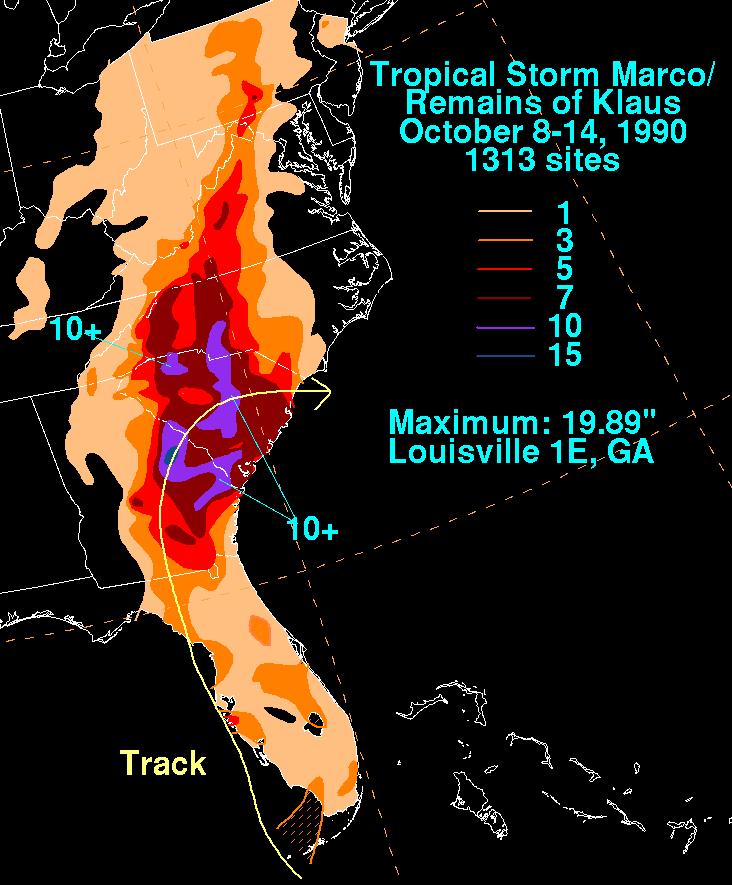
October 8
- 8:00 a.m. EDT (1200 UTC) - Tropical Depression Klaus re-strengthened into a tropical storm.
October 9
- 8:00 a.m. EDT (1200 UTC) - Tropical Depression Fourteen formed near CaibariénCaibariénCaibarién is a municipality city in the Villa Clara province of Cuba.Caibarien is known as "La Villa Blanca" for its sands and beaches. They are famous for their "Parrandas" along with Remedios and Camajuani.-History:The town was founded on October 26, 1832 from a map designed by Estratón Bauza...
, Cuba. - 2:00 p.m. EDT (1800 UTC) - Tropical Storm Klaus was absorbed by a low pressure system.
October 10
- 2:00 p.m. EDT (1800 UTC) - Tropical Depression Fourteen strengthened into Tropical Storm MarcoTropical Storm Marco (1990)Tropical Storm Marco was the only tropical cyclone to make landfall on the United States during the 1990 Atlantic hurricane season. The 13th named storm of the season, Marco formed from a cold-core low pressure area along the northern coast of Cuba on October 9, and tracked northwestward...
. - 8:00 p.m. EDT (0000 UTC October 11) - The subtropical cyclone acquired tropical characteristics and strengthened into Hurricane LiliHurricane Lili (1990)Hurricane Lili was a moderate tropical cyclone of the 1990 Atlantic hurricane season. It began as a subtropical cyclone over the central Atlantic and became a hurricane while moving westward toward the United States. Lili did not gain any additional strength before curving away from land and...
. Simultaneously, Hurricane Lili attained its peak intensity with winds of 75 mph (120 km/h) and a minimum pressure of 987 mbar (hPa; 29.15 inHg).
October 11
- 2:00 a.m. EDT (0600 UTC) - Tropical Storm Marco attained its peak intensity with winds of 65 mph (100 km/h) and a minimum pressure of 989 mbar (hPa; 29.21 inHg).
- 8:00 p.m. EDT (0000 UTC October 12) - Tropical Storm Marco weakened back to a tropical depression while making landfall near Cedar Key, FloridaCedar Key, FloridaCedar Key is a city in Levy County, Florida, United States. The population was 790 at the 2000 census. According to the U.S Census estimates of 2005, the city had a population of 958. The Cedar Keys are a cluster of islands close to the mainland. Most of the developed area of the city has been on...
.
- 2:00 p.m. EDT (1200 UTC) - Tropical Depression Marco became extratropical on the Florida/GeorgiaGeorgia (U.S. state)Georgia is a state located in the southeastern United States. It was established in 1732, the last of the original Thirteen Colonies. The state is named after King George II of Great Britain. Georgia was the fourth state to ratify the United States Constitution, on January 2, 1788...
border.
October 13
- 8:00 a.m. EDT (1200 UTC) - Hurricane Lili weakened back to a tropical storm.
October 14
- 8:00 p.m. EDT (0000 UTC October 15) - Tropical Storm Lili became extratropical just offshore of Nova Scotia.
October 15
- 8:00 p.m. EDT (0000 UTC October 16) - Tropical Depression Fifteen formed northeast of the Lesser Antilles.
October 16
- 2:00 p.m. EDT (1800 UTC) - Tropical Depression Fifteen strengthened into Tropical Storm Nana, making the 1990 Atlantic hurricane season the most active in number of named storms since 19691969 Atlantic hurricane seasonThe 1969 Atlantic hurricane season officially began on June 1, 1969, and lasted until November 30, 1969. These dates conventionally delimit the period of each year when most tropical cyclones form in the Atlantic basin. The season was among the most active on record, with 18 tropical cyclones, 12...
, but would be surpassed or tied several times in the upcoming seasons.
October 17
- 2:00 p.m. EDT (1800 UTC) - Tropical Storm Nana strengthened into Hurricane Nana.
October 19
- 8:00 a.m. EDT (1200 UTC) - Hurricane Nana attained its peak intensity with winds of 85 mph (140 km/h) and a minimum pressure of 989 mbar (hPa; 29.21 inHg).
- 8:00 p.m. EDT (0000 UTC October 20) - Hurricane Nana weakened back to a tropical storm.
October 20
- 8:00 p.m. EDT (0000 UTC October 21) - Tropical Storm Nana weakened back to a tropical depression.
October 21
- 2:00 p.m. EDT (1800 UTC) - Tropical Depression Nana dissipated south of BermudaBermudaBermuda is a British overseas territory in the North Atlantic Ocean. Located off the east coast of the United States, its nearest landmass is Cape Hatteras, North Carolina, about to the west-northwest. It is about south of Halifax, Nova Scotia, Canada, and northeast of Miami, Florida...
.
November
November 30- 11:59 p.m. AST (0359 UTC December 1) – The 1990 Atlantic hurricane season officially ends.