
Hurricane Klaus
Encyclopedia
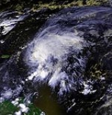
Hurricane Klaus was a minimal Atlantic hurricane that dropped heavy rainfall across the Lesser Antilles
in October 1990. The eleventh tropical cyclone
and sixth hurricane of the 1990 Atlantic hurricane season
, Klaus developed from a tropical wave
on October 3 a short distance east of Dominica
. It drifted northwestward, and quickly intensified to attain hurricane status on October 5. Though its closest approach to the Lesser Antilles was within 12 miles (19 km), the strongest winds remained to its northeast due to strong wind shear
, which caused Klaus to steadily weaken. After deteriorating into a tropical depression, Klaus briefly restrengthened over the Bahamas before dissipating on October 9 under the influence of developing tropical storm, Marco
.
The hurricane affected many areas which were devastated by Hurricane Hugo
in the previous year. Heavy rainfall on Saint Lucia
destroyed about 15% of its yearly banana crop. Damage was heaviest on Martinique
, where seven casualties occurred and 1,500 people were left homeless. The rainfall caused severe flooding on the island, resulting in some landslides. The remnant moisture of Klaus entered the southeastern United States
, dropping heavy rainfall and causing four casualties; the same area was affected with more precipitation a few days later by Tropical Storm Marco. Due to the damage caused by the storm, the name Klaus was retired from the list of tropical cyclone names.
moved off the coast of Africa
on September 27. It tracked westward to the south of a subtropical ridge
, becoming convectively active, and a low-level circulation was observed as it passed south of the Cape Verde
islands on September 28. The organization of the convection oscillated over the subsequent days, and a few times the system showed signs of developing into a tropical depression. As it approached the Lesser Antilles
it organized further, and despite unfavorable upper-level wind shear
the system developed into Tropical Depression Thirteen on October 3 while located about 115 miles (185 km/h) east of Dominica
. Located in an area of weak steering currents, the depression drifted to the northwest, and about six hours after first developing the cyclone intensified into a tropical storm; the National Hurricane Center
designated it with the name Klaus
.
Upon becoming a tropical storm, Klaus was located in an area of 29 mph (47 km/h) of wind shear, although concurrently it was located over warm water temperatures of 83.1° F (28.4° C). Tracking through a highly baroclinic
environment, the storm became better organized, and at 1200 UTC on October 5 Klaus attained hurricane status about 30 miles (50 km) east of Antigua
; shortly thereafter, it passed 12 miles (19 km) east of Barbuda
, its closest point of approach to the Lesser Antilles. Klaus reached peak winds of 80 mph (130 km/h) and a minimum central pressure of 985 mbar
, though most of its deep convection and strong winds remained to its northeast due to wind shear. At the time the hurricane was forecast to continue tracking to the north-northwest. However, after weakening to a tropical storm on October 6, Klaus turned westward.
Klaus continued tracking just north of the Lesser Antilles, and after continuing to deteriorate from the wind shear, the cyclone weakened to a tropical depression on October 8 to the north of Puerto Rico
. Later that day, convection redeveloped over the center, and Klaus re-attained tropical storm status as it accelerated toward the northeast Bahamas; it briefly reached winds of 50 mph (85 km/h). A low pressure area to its west over Cuba
had been steadily intensifying and building toward the surface, and on October 9 it developed into a tropical depression; the cyclone became the dominant system, eventually becoming Marco
, and Klaus dissipated under the influence of the system late on October 9. The remnant moisture continued to the northwest, reaching the coast of South Carolina
by October 11.
was issued for the northern Leeward Islands
from Saint Martin
to Antigua
, which was upgraded to a hurricane warning as its quick strengthening became apparent; additionally, the government of France
issued a tropical storm warning for Guadeloupe
. A hurricane watch was issued for the Virgin Islands
, though it was dropped as Klaus began to weaken. In Guadeloupe, officials advised citizens to transport livestock to safer areas, and also to avoid potentially flooded areas. Prior to its arrival, schools were closed in Martinique
, Sint Maarten, and Antigua
. The VC Bird International Airport
was closed during the passage of the hurricane.
Later in its duration, the government of The Bahamas
issued a tropical storm warning for the central and later northern Bahamas, though it was discontinued as the cyclone dissipated.
Due to Hurricane Klaus, Space Shuttle Columbia's launch was delayed.
, potentially as high as 15 inches (380 mm); the hurricane affected many areas struck by Hurricane Hugo
in the previous year. On Barbados
, flooding from the rainfall blocked a few roads and forced a few families to move to safer areas; lightning from the outskirts of the storm left a portion of the island without power. High winds and rainfall affected the island of Saint Lucia
, which destroyed about 15% of the nation's banana crop for the year; damage totaled about $1 million (1990 USD
, $1.6 million 2007 USD).
The rainfall resulted in severe flooding on Martinique
, which accrued to almost 10 feet (3 m) in some locations; two sisters drowned near Saint-Joseph
after a bridge was washed away. Several landslide
s were reported on the island. The passage of the cyclone left damaged and power and telephone systems. 750 people evacuated their homes in Le Lamentin
due to flooding, and a total of 1,500 residents were left homeless on the island. Offshore, rough conditions damaged a fishing vessel, leaving its two passengers drifting on the boat for 25 days before being rescued about 640 miles (1035 km) to the north-northwest of Martinique. In all, seven people were killed on the island.
On Dominica
, winds from the hurricane damaged power lines and downed trees in the northern portion of the island. High winds on Antigua
damaged a few roofs, and also downed communications from two radio networks. The outer rainbands of the storm dropped light rainfall on the United States Virgin Islands
, reaching about 1.25 inches (32 mm) on Saint Thomas
; wind gusts peaked at 33 mph (53 km/h) on Saint Croix
. Moderate rainfall continued into the Turks and Caicos Islands
, with Grand Turk
reporting a total of 4 inches (100 mm) in 36 hours.
On the east coast of Florida
, Klaus produced 15 foot (4.5 m) waves and tides of 3 feet (1 m) above normal. Beach erosion was reported along the east coast, due to persistent easterly winds. As the remnant moisture of Klaus entered the southeastern United States
, it produced heavy rainfall between 10–15 inches (250–380 mm) of rainfall in South Carolina
, with slightly lower totals in North Carolina
. In South Carolina, the rainfall caused a dam to burst, killing four people. About two days after the remnants of Klaus entered the southeastern United States, Tropical Storm Marco
made landfall on northwestern Florida
, dropping more heavy rainfall and causing heavy damage across the region.
, the government of France
requested the retirement of the name Klaus; the World Meteorological Organization
retired the name from the list of tropical cyclone names in the following year and replaced it with the name Kyle.
Lesser Antilles
The Lesser Antilles are a long, partly volcanic island arc in the Western Hemisphere. Most of its islands form the eastern boundary of the Caribbean Sea with the Atlantic Ocean, with the remainder located in the southern Caribbean just north of South America...
in October 1990. The eleventh tropical cyclone
Tropical cyclone
A tropical cyclone is a storm system characterized by a large low-pressure center and numerous thunderstorms that produce strong winds and heavy rain. Tropical cyclones strengthen when water evaporated from the ocean is released as the saturated air rises, resulting in condensation of water vapor...
and sixth hurricane of the 1990 Atlantic hurricane season
1990 Atlantic hurricane season
The 1990 Atlantic hurricane season was the most active Atlantic hurricane season since 1969. It officially began on June 1, 1990, and lasted until November 30, 1990. These dates conventionally delimit the period of each year when most tropical cyclones form in the Atlantic basin...
, Klaus developed from a tropical wave
Tropical wave
Tropical waves, easterly waves, or tropical easterly waves, also known as African easterly waves in the Atlantic region, are a type of atmospheric trough, an elongated area of relatively low air pressure, oriented north to south, which move from east to west across the tropics causing areas of...
on October 3 a short distance east of Dominica
Dominica
Dominica , officially the Commonwealth of Dominica, is an island nation in the Lesser Antilles region of the Caribbean Sea, south-southeast of Guadeloupe and northwest of Martinique. Its size is and the highest point in the country is Morne Diablotins, which has an elevation of . The Commonwealth...
. It drifted northwestward, and quickly intensified to attain hurricane status on October 5. Though its closest approach to the Lesser Antilles was within 12 miles (19 km), the strongest winds remained to its northeast due to strong wind shear
Wind shear
Wind shear, sometimes referred to as windshear or wind gradient, is a difference in wind speed and direction over a relatively short distance in the atmosphere...
, which caused Klaus to steadily weaken. After deteriorating into a tropical depression, Klaus briefly restrengthened over the Bahamas before dissipating on October 9 under the influence of developing tropical storm, Marco
Tropical Storm Marco (1990)
Tropical Storm Marco was the only tropical cyclone to make landfall on the United States during the 1990 Atlantic hurricane season. The 13th named storm of the season, Marco formed from a cold-core low pressure area along the northern coast of Cuba on October 9, and tracked northwestward...
.
The hurricane affected many areas which were devastated by Hurricane Hugo
Hurricane Hugo
Hurricane Hugo was a classical, destructive and rare Cape Verde-type hurricane which struck the Caribbean islands of Guadeloupe, Montserrat, St. Croix, Puerto Rico and the USA mainland in South Carolina as a Category 4 hurricane during September of the 1989 Atlantic hurricane season...
in the previous year. Heavy rainfall on Saint Lucia
Saint Lucia
Saint Lucia is an island country in the eastern Caribbean Sea on the boundary with the Atlantic Ocean. Part of the Lesser Antilles, it is located north/northeast of the island of Saint Vincent, northwest of Barbados and south of Martinique. It covers a land area of 620 km2 and has an...
destroyed about 15% of its yearly banana crop. Damage was heaviest on Martinique
Martinique
Martinique is an island in the eastern Caribbean Sea, with a land area of . Like Guadeloupe, it is an overseas region of France, consisting of a single overseas department. To the northwest lies Dominica, to the south St Lucia, and to the southeast Barbados...
, where seven casualties occurred and 1,500 people were left homeless. The rainfall caused severe flooding on the island, resulting in some landslides. The remnant moisture of Klaus entered the southeastern United States
United States
The United States of America is a federal constitutional republic comprising fifty states and a federal district...
, dropping heavy rainfall and causing four casualties; the same area was affected with more precipitation a few days later by Tropical Storm Marco. Due to the damage caused by the storm, the name Klaus was retired from the list of tropical cyclone names.
Meteorological history
A tropical waveTropical wave
Tropical waves, easterly waves, or tropical easterly waves, also known as African easterly waves in the Atlantic region, are a type of atmospheric trough, an elongated area of relatively low air pressure, oriented north to south, which move from east to west across the tropics causing areas of...
moved off the coast of Africa
Africa
Africa is the world's second largest and second most populous continent, after Asia. At about 30.2 million km² including adjacent islands, it covers 6% of the Earth's total surface area and 20.4% of the total land area...
on September 27. It tracked westward to the south of a subtropical ridge
Subtropical ridge
The subtropical ridge is a significant belt of high pressure situated around the latitudes of 30°N in the Northern Hemisphere and 30°S in the Southern Hemisphere. It is characterized by mostly calm winds, which acts to reduce air quality under its axis by causing fog overnight, and haze during...
, becoming convectively active, and a low-level circulation was observed as it passed south of the Cape Verde
Cape Verde
The Republic of Cape Verde is an island country, spanning an archipelago of 10 islands located in the central Atlantic Ocean, 570 kilometres off the coast of Western Africa...
islands on September 28. The organization of the convection oscillated over the subsequent days, and a few times the system showed signs of developing into a tropical depression. As it approached the Lesser Antilles
Lesser Antilles
The Lesser Antilles are a long, partly volcanic island arc in the Western Hemisphere. Most of its islands form the eastern boundary of the Caribbean Sea with the Atlantic Ocean, with the remainder located in the southern Caribbean just north of South America...
it organized further, and despite unfavorable upper-level wind shear
Wind shear
Wind shear, sometimes referred to as windshear or wind gradient, is a difference in wind speed and direction over a relatively short distance in the atmosphere...
the system developed into Tropical Depression Thirteen on October 3 while located about 115 miles (185 km/h) east of Dominica
Dominica
Dominica , officially the Commonwealth of Dominica, is an island nation in the Lesser Antilles region of the Caribbean Sea, south-southeast of Guadeloupe and northwest of Martinique. Its size is and the highest point in the country is Morne Diablotins, which has an elevation of . The Commonwealth...
. Located in an area of weak steering currents, the depression drifted to the northwest, and about six hours after first developing the cyclone intensified into a tropical storm; the National Hurricane Center
National Hurricane Center
The National Hurricane Center , located at Florida International University in Miami, Florida, is the division of the National Weather Service responsible for tracking and predicting weather systems within the tropics between the Prime Meridian and the 140th meridian west poleward to the 30th...
designated it with the name Klaus
Klaus
Klaus is a German given name and surname. It originated as a short form of Nikolaus, a German form of the given name Nicholas.-Notable persons whose family name is Klaus:*Billy Klaus, baseball player.*Chris Klaus, entrepreneur....
.
Upon becoming a tropical storm, Klaus was located in an area of 29 mph (47 km/h) of wind shear, although concurrently it was located over warm water temperatures of 83.1° F (28.4° C). Tracking through a highly baroclinic
Baroclinity
In fluid dynamics, the baroclinity of a stratified fluid is a measure of how misaligned the gradient of pressure is from the gradient of density in a fluid...
environment, the storm became better organized, and at 1200 UTC on October 5 Klaus attained hurricane status about 30 miles (50 km) east of Antigua
Antigua
Antigua , also known as Waladli, is an island in the West Indies, in the Leeward Islands in the Caribbean region, the main island of the country of Antigua and Barbuda. Antigua means "ancient" in Spanish and was named by Christopher Columbus after an icon in Seville Cathedral, Santa Maria de la...
; shortly thereafter, it passed 12 miles (19 km) east of Barbuda
Barbuda
Barbuda is an island in the Eastern Caribbean, and forms part of the state of Antigua and Barbuda. It has a population of about 1,500, most of whom live in the town of Codrington.-Location:...
, its closest point of approach to the Lesser Antilles. Klaus reached peak winds of 80 mph (130 km/h) and a minimum central pressure of 985 mbar
Bar (unit)
The bar is a unit of pressure equal to 100 kilopascals, and roughly equal to the atmospheric pressure on Earth at sea level. Other units derived from the bar are the megabar , kilobar , decibar , centibar , and millibar...
, though most of its deep convection and strong winds remained to its northeast due to wind shear. At the time the hurricane was forecast to continue tracking to the north-northwest. However, after weakening to a tropical storm on October 6, Klaus turned westward.
Klaus continued tracking just north of the Lesser Antilles, and after continuing to deteriorate from the wind shear, the cyclone weakened to a tropical depression on October 8 to the north of Puerto Rico
Puerto Rico
Puerto Rico , officially the Commonwealth of Puerto Rico , is an unincorporated territory of the United States, located in the northeastern Caribbean, east of the Dominican Republic and west of both the United States Virgin Islands and the British Virgin Islands.Puerto Rico comprises an...
. Later that day, convection redeveloped over the center, and Klaus re-attained tropical storm status as it accelerated toward the northeast Bahamas; it briefly reached winds of 50 mph (85 km/h). A low pressure area to its west over Cuba
Cuba
The Republic of Cuba is an island nation in the Caribbean. The nation of Cuba consists of the main island of Cuba, the Isla de la Juventud, and several archipelagos. Havana is the largest city in Cuba and the country's capital. Santiago de Cuba is the second largest city...
had been steadily intensifying and building toward the surface, and on October 9 it developed into a tropical depression; the cyclone became the dominant system, eventually becoming Marco
Tropical Storm Marco (1990)
Tropical Storm Marco was the only tropical cyclone to make landfall on the United States during the 1990 Atlantic hurricane season. The 13th named storm of the season, Marco formed from a cold-core low pressure area along the northern coast of Cuba on October 9, and tracked northwestward...
, and Klaus dissipated under the influence of the system late on October 9. The remnant moisture continued to the northwest, reaching the coast of South Carolina
South Carolina
South Carolina is a state in the Deep South of the United States that borders Georgia to the south, North Carolina to the north, and the Atlantic Ocean to the east. Originally part of the Province of Carolina, the Province of South Carolina was one of the 13 colonies that declared independence...
by October 11.
Preparations
Shortly after Klaus attained tropical storm status early on October 4, a tropical storm warningTropical cyclone warnings and watches
Warnings and watches are two levels of alert issued by national weather forecasting bodies to coastal areas threatened by the imminent approach of a tropical cyclone of tropical storm or hurricane intensity. They are notices to the local population and civil authorities to make appropriate...
was issued for the northern Leeward Islands
Leeward Islands
The Leeward Islands are a group of islands in the West Indies. They are the northern islands of the Lesser Antilles chain. As a group they start east of Puerto Rico and reach southward to Dominica. They are situated where the northeastern Caribbean Sea meets the western Atlantic Ocean...
from Saint Martin
Saint Martin
Saint Martin is an island in the northeast Caribbean, approximately east of Puerto Rico. The 87 km2 island is divided roughly 60/40 between France and the Kingdom of the Netherlands ; however, the Dutch side has the larger population. It is one of the smallest sea islands divided between...
to Antigua
Antigua
Antigua , also known as Waladli, is an island in the West Indies, in the Leeward Islands in the Caribbean region, the main island of the country of Antigua and Barbuda. Antigua means "ancient" in Spanish and was named by Christopher Columbus after an icon in Seville Cathedral, Santa Maria de la...
, which was upgraded to a hurricane warning as its quick strengthening became apparent; additionally, the government of France
France
The French Republic , The French Republic , The French Republic , (commonly known as France , is a unitary semi-presidential republic in Western Europe with several overseas territories and islands located on other continents and in the Indian, Pacific, and Atlantic oceans. Metropolitan France...
issued a tropical storm warning for Guadeloupe
Guadeloupe
Guadeloupe is an archipelago located in the Leeward Islands, in the Lesser Antilles, with a land area of 1,628 square kilometres and a population of 400,000. It is the first overseas region of France, consisting of a single overseas department. As with the other overseas departments, Guadeloupe...
. A hurricane watch was issued for the Virgin Islands
Virgin Islands
The Virgin Islands are the western island group of the Leeward Islands, which are the northern part of the Lesser Antilles, which form the border between the Caribbean Sea and the Atlantic Ocean...
, though it was dropped as Klaus began to weaken. In Guadeloupe, officials advised citizens to transport livestock to safer areas, and also to avoid potentially flooded areas. Prior to its arrival, schools were closed in Martinique
Martinique
Martinique is an island in the eastern Caribbean Sea, with a land area of . Like Guadeloupe, it is an overseas region of France, consisting of a single overseas department. To the northwest lies Dominica, to the south St Lucia, and to the southeast Barbados...
, Sint Maarten, and Antigua
Antigua
Antigua , also known as Waladli, is an island in the West Indies, in the Leeward Islands in the Caribbean region, the main island of the country of Antigua and Barbuda. Antigua means "ancient" in Spanish and was named by Christopher Columbus after an icon in Seville Cathedral, Santa Maria de la...
. The VC Bird International Airport
VC Bird International Airport
V. C. Bird International Airport is located on the island of Antigua, northeast of St. John's, the capital of Antigua and Barbuda.- History :...
was closed during the passage of the hurricane.
Later in its duration, the government of The Bahamas
The Bahamas
The Bahamas , officially the Commonwealth of the Bahamas, is a nation consisting of 29 islands, 661 cays, and 2,387 islets . It is located in the Atlantic Ocean north of Cuba and Hispaniola , northwest of the Turks and Caicos Islands, and southeast of the United States...
issued a tropical storm warning for the central and later northern Bahamas, though it was discontinued as the cyclone dissipated.
Due to Hurricane Klaus, Space Shuttle Columbia's launch was delayed.
Impact
Hurricane Klaus dropped moderate to heavy rainfall across the Lesser AntillesLesser Antilles
The Lesser Antilles are a long, partly volcanic island arc in the Western Hemisphere. Most of its islands form the eastern boundary of the Caribbean Sea with the Atlantic Ocean, with the remainder located in the southern Caribbean just north of South America...
, potentially as high as 15 inches (380 mm); the hurricane affected many areas struck by Hurricane Hugo
Hurricane Hugo
Hurricane Hugo was a classical, destructive and rare Cape Verde-type hurricane which struck the Caribbean islands of Guadeloupe, Montserrat, St. Croix, Puerto Rico and the USA mainland in South Carolina as a Category 4 hurricane during September of the 1989 Atlantic hurricane season...
in the previous year. On Barbados
Barbados
Barbados is an island country in the Lesser Antilles. It is in length and as much as in width, amounting to . It is situated in the western area of the North Atlantic and 100 kilometres east of the Windward Islands and the Caribbean Sea; therein, it is about east of the islands of Saint...
, flooding from the rainfall blocked a few roads and forced a few families to move to safer areas; lightning from the outskirts of the storm left a portion of the island without power. High winds and rainfall affected the island of Saint Lucia
Saint Lucia
Saint Lucia is an island country in the eastern Caribbean Sea on the boundary with the Atlantic Ocean. Part of the Lesser Antilles, it is located north/northeast of the island of Saint Vincent, northwest of Barbados and south of Martinique. It covers a land area of 620 km2 and has an...
, which destroyed about 15% of the nation's banana crop for the year; damage totaled about $1 million (1990 USD
United States dollar
The United States dollar , also referred to as the American dollar, is the official currency of the United States of America. It is divided into 100 smaller units called cents or pennies....
, $1.6 million 2007 USD).
The rainfall resulted in severe flooding on Martinique
Martinique
Martinique is an island in the eastern Caribbean Sea, with a land area of . Like Guadeloupe, it is an overseas region of France, consisting of a single overseas department. To the northwest lies Dominica, to the south St Lucia, and to the southeast Barbados...
, which accrued to almost 10 feet (3 m) in some locations; two sisters drowned near Saint-Joseph
Saint-Joseph, Martinique
Saint-Joseph is a commune in the Arrondissement of Fort-de-France on Martinique.-References:*...
after a bridge was washed away. Several landslide
Landslide
A landslide or landslip is a geological phenomenon which includes a wide range of ground movement, such as rockfalls, deep failure of slopes and shallow debris flows, which can occur in offshore, coastal and onshore environments...
s were reported on the island. The passage of the cyclone left damaged and power and telephone systems. 750 people evacuated their homes in Le Lamentin
Le Lamentin
Le Lamentin is a town and the second-largest commune in the French overseas department of Martinique.It is located in the center of the island of Martinique, and is part of the metropolitan area of Fort-de-France, the largest conurbation in Martinique. In the 1999 census, Le Lamentin had a...
due to flooding, and a total of 1,500 residents were left homeless on the island. Offshore, rough conditions damaged a fishing vessel, leaving its two passengers drifting on the boat for 25 days before being rescued about 640 miles (1035 km) to the north-northwest of Martinique. In all, seven people were killed on the island.
On Dominica
Dominica
Dominica , officially the Commonwealth of Dominica, is an island nation in the Lesser Antilles region of the Caribbean Sea, south-southeast of Guadeloupe and northwest of Martinique. Its size is and the highest point in the country is Morne Diablotins, which has an elevation of . The Commonwealth...
, winds from the hurricane damaged power lines and downed trees in the northern portion of the island. High winds on Antigua
Antigua
Antigua , also known as Waladli, is an island in the West Indies, in the Leeward Islands in the Caribbean region, the main island of the country of Antigua and Barbuda. Antigua means "ancient" in Spanish and was named by Christopher Columbus after an icon in Seville Cathedral, Santa Maria de la...
damaged a few roofs, and also downed communications from two radio networks. The outer rainbands of the storm dropped light rainfall on the United States Virgin Islands
United States Virgin Islands
The Virgin Islands of the United States are a group of islands in the Caribbean that are an insular area of the United States. The islands are geographically part of the Virgin Islands archipelago and are located in the Leeward Islands of the Lesser Antilles.The U.S...
, reaching about 1.25 inches (32 mm) on Saint Thomas
Saint Thomas, U.S. Virgin Islands
Saint Thomas is an island in the Caribbean Sea and with the islands of Saint John, Saint Croix, and Water Island a county and constituent district of the United States Virgin Islands , an unincorporated territory of the United States. Located on the island is the territorial capital and port of...
; wind gusts peaked at 33 mph (53 km/h) on Saint Croix
Saint Croix, U.S. Virgin Islands
Saint Croix is an island in the Caribbean Sea, and a county and constituent district of the United States Virgin Islands , an unincorporated territory of the United States. Formerly the Danish West Indies, they were sold to the United States by Denmark in the Treaty of the Danish West Indies of...
. Moderate rainfall continued into the Turks and Caicos Islands
Turks and Caicos Islands
The Turks and Caicos Islands are a British Overseas Territory and overseas territory of the European Union consisting of two groups of tropical islands in the Caribbean, the larger Caicos Islands and the smaller Turks Islands, known for tourism and as an offshore financial centre.The Turks and...
, with Grand Turk
Grand Turk Island
Grand Turk Island is an island in the Turks and Caicos Islands. It is the largest island in the Turks Islands with . It contains the territory's capital, Cockburn Town and the JAGS McCartney International Airport...
reporting a total of 4 inches (100 mm) in 36 hours.
On the east coast of Florida
Florida
Florida is a state in the southeastern United States, located on the nation's Atlantic and Gulf coasts. It is bordered to the west by the Gulf of Mexico, to the north by Alabama and Georgia and to the east by the Atlantic Ocean. With a population of 18,801,310 as measured by the 2010 census, it...
, Klaus produced 15 foot (4.5 m) waves and tides of 3 feet (1 m) above normal. Beach erosion was reported along the east coast, due to persistent easterly winds. As the remnant moisture of Klaus entered the southeastern United States
United States
The United States of America is a federal constitutional republic comprising fifty states and a federal district...
, it produced heavy rainfall between 10–15 inches (250–380 mm) of rainfall in South Carolina
South Carolina
South Carolina is a state in the Deep South of the United States that borders Georgia to the south, North Carolina to the north, and the Atlantic Ocean to the east. Originally part of the Province of Carolina, the Province of South Carolina was one of the 13 colonies that declared independence...
, with slightly lower totals in North Carolina
North Carolina
North Carolina is a state located in the southeastern United States. The state borders South Carolina and Georgia to the south, Tennessee to the west and Virginia to the north. North Carolina contains 100 counties. Its capital is Raleigh, and its largest city is Charlotte...
. In South Carolina, the rainfall caused a dam to burst, killing four people. About two days after the remnants of Klaus entered the southeastern United States, Tropical Storm Marco
Tropical Storm Marco (1990)
Tropical Storm Marco was the only tropical cyclone to make landfall on the United States during the 1990 Atlantic hurricane season. The 13th named storm of the season, Marco formed from a cold-core low pressure area along the northern coast of Cuba on October 9, and tracked northwestward...
made landfall on northwestern Florida
Florida
Florida is a state in the southeastern United States, located on the nation's Atlantic and Gulf coasts. It is bordered to the west by the Gulf of Mexico, to the north by Alabama and Georgia and to the east by the Atlantic Ocean. With a population of 18,801,310 as measured by the 2010 census, it...
, dropping more heavy rainfall and causing heavy damage across the region.
Retirement
Due to its impact on MartiniqueMartinique
Martinique is an island in the eastern Caribbean Sea, with a land area of . Like Guadeloupe, it is an overseas region of France, consisting of a single overseas department. To the northwest lies Dominica, to the south St Lucia, and to the southeast Barbados...
, the government of France
France
The French Republic , The French Republic , The French Republic , (commonly known as France , is a unitary semi-presidential republic in Western Europe with several overseas territories and islands located on other continents and in the Indian, Pacific, and Atlantic oceans. Metropolitan France...
requested the retirement of the name Klaus; the World Meteorological Organization
World Meteorological Organization
The World Meteorological Organization is an intergovernmental organization with a membership of 189 Member States and Territories. It originated from the International Meteorological Organization , which was founded in 1873...
retired the name from the list of tropical cyclone names in the following year and replaced it with the name Kyle.
See also
- List of retired Atlantic hurricane names
- List of North Carolina hurricanes (1980–present)
External links
- [ftp://ftp.nhc.noaa.gov/pub/storm_archives/atlantic/prelimat/atl1990/klaus/ NHC Klaus Preliminary Report (gif format)]
- 1990 Monthly Weather Review