

St Mary's Island, Karnataka
Encyclopedia
St. Mary's Islands also known as Coconut Island, are a set of four small islands in the Arabian Sea
off the coast of Malpe
in Udupi, Karnataka
, India
. They are known for their distinctive geological formation of columnar basaltic lava (pictured).
Scientific studies indicate that the basalt of the St. Mary's Islands was formed by sub-aerial subvolcanic
activity, because at that time Madagascar
was attached to India. The rifting of Madagascar took place around 88 Ma.
The islands form one of the four geological monuments in Karnataka state, out of the 26 Geological Monuments of India declared by the Geological Survey of India
in 2001. The monument is considered an important site for "Geo Tourism".
landed at St. Mary's Islands on his voyage from Portugal
to India, fixed a cross on the island
and named one of these islands, El Padron de Santa Maria, as a dedication to Mother Mary
, before he proceeded to Kozhikode in Kerala
. It is from this name that the islands have got their current name.
The north-south alined islands are in a non continuous chain. The four large islands are Coconut Island, North Island, Daryabahadurgarh Island and South Island.
The type of rock formation seen on Coconut island is also found atn the Giant's Causeway
in Northern Ireland
. The stretch of sea between the islands and the long curve of the beach at Malpe is serene and calm.
The islands are generally aligned parallel to the coast line, which provide clues to the phenomenon of uplift of the west coast of India. The islands' terraces and elevated beach deposits along with the tide gauge data at the dead oyster beach in Suratkal beach (further south of the islands) have been deduced as proof of the reported fall in sea level of about 1 mm/per year.
The highest elevation at Coconut Island, which has generated interest among geologists and tourists, is about 10 m (32.8 ft) above msl with surrounding areas in the form of platforms in the elevation range of +6 m (19.7 ft), +3 m (9.8 ft), +1.5 m (4.9 ft) and + 0 m which are stated to have been formed by wave action pointing to an "episodic sea level rise or fall of land".
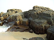 The columnar basaltic lava found in these Islands, which is very well developed in the basalts of Deccan Trap, exhibit an imposing range of hexagonal shaped or multi-faced (polygonal) columns split into a horizontal mosaic. In geological idiom these are called "Columnar Joints". The lava rocks form regular five, six or seven-sided pillars, called "laminar lava", and are found in varying heights in all the islands; the tallest of the columns is about 6 m. Considering the importance and rarity of such an occurrence, these islands were classified as a National Geological Monument in 2001 by the Geological Survey of India
.
The Deccan Trap, of about 60 million years vintage (Cretaceous
–Eocene
time), emerged from the vast deluge of hot molten basaltic lava in the western part of India which is now seen as flat topped hills and step like terraces.
Scientific studies carried out at the Indian Institute of Technology, Bombay on the Petrology
, Palaeomagnetism and Volcanics of the rocks of the island has brought out the following facts.
An analysis of Palaeomagnetic data from India and Madagascar
hypothesizes a new India–Madagascar fit related to the Late Cretaceous, directly prior to and during the early phase of Madagascar–India separation. A scientific study paper on Late Cretaceous India–Madagascar fit and timing of break–up related magmatism by several scholars reported in the Wiley Inter Science Journal states:.
and are reported to be non-existent in the Rajmahal Traps. Six selected samples from the Islands were subject to whole rock K-Ar dating. This yielded a mean age of 93.1 + 2.4 (2σ) vis-à-vis the age of the Rajmahal Traps of about 105-100 Ma and about 65-35 Ma of the Deccan Traps
. With this appreciation, the author has concluded that the igneous activity of St. Mary's Islands may represent Cretaceous
-Tertiary
igneous activity.
In a further analysis of the age of the break-up of Greater India (India plus Seychelles
) and Madagascar carried out by the scientists of the Physical Research Laboratory, Ahmedabad
, India reported in a scientific paper in Earth and Planetary Science Letters, it has been inferred to have occurred in the Upper Cretaceous at 88 Ma. The strength of this inference is based on the approach that the Felsic
volcanics (rhyolites and Rhyodacite
s) of the St. Mary's Islands (SMI), Southern India, were originally interpreted as a distant outlier of the 65 Ma Deccan volcanic province of west–central India, comprising dominantly flood basalts. Later studies had dated it at 93 Ma by the K-Ar dating technique. Since the technique used was a simple use of an average of five out of six widely varying dates and arbitrary data selectivity chosen, the results were not considered reliable. A method of 40Ar–39Ar (Argon argon dating) of the SMI volcanic yields is reportedly more reliable of the plateau and isochron
ages. The weighted mean isochron age is reported to be 85.6±0.9 Ma (2σ). The K–Ar (Potassium-argon dating
) technique adopted for the southern Indian Precambrian
terrain, intruded by numerous mafic–doleritic dyke swarms, the age from Proterozoic
to the latest Cretaceous is reported as 69–65 Ma, (Deccan-related). The two regional dykes (a leucograbbro and a felsite) from the Kerala
region of southwestern India, which were also dated earlier, indicate the age as 85 Ma. Madagascar flood basalt province's 40Ar–39Ar ages of 89–85 Ma tallies with the Saint Mary's Islands' volcanic age. The conclusion drawn by the study is that the Madagascar flood basalt province, the SMI volcanics, and possibly the Kerala dykes may well represent volcanic activity associated with the break-up of Greater India (India plus Seychelles
) and Madagascar, in the Upper Cretaceous at 88 Ma.
Another scientific study on the biogeographic and tectonic history of India by Briggs reported in the Journal of Biogeography (2003)it is concluded that:
haven with seashells of various shapes and sizes littered along the coast. There is no sand beach to swim and relax since it is scatted with basaltic rocks. But there are flat slabs to sit and enjoy the serenity of the place. The beach has security guards who ensure that visitors do not venture into danger zones of the islands. Watching Sun set at the Islands is also a special sight. It is a popular picnic spot with locals and tourists alike. December to March is the best season to visit the Islands.
All links to the island are only through the mainland town of Malpe, which is a major fishing harbor. The beach at this location is enlivening. It is located at a distance of 5 km west of Udupi town, the administrative headquarters for the Islands. Apart from the Islands, Malpe too has tourist attractions such as the Vadabhandeshwara Temple and an image of Sri Balarama consecrated by the saint Madhwacharya the founder of Dvaita
Philosophy.
A detailed description of the natural flora
and fauna
of the Islands and the Deria Bahdur Ghur, have been compiled in a manual by John Sturrocks who was the district collector of Mangalore at that time in 1894.
Flora and fauna
Colonies of Gulls, Scolopacidae
(sandpipers) and a few crow
s have been sighted on the Islands. But on the approach to the Islands from the Malpe beach, Brahminy Kite
s (Haliastur indus)), Great White Egrets, Grey Egrets (breeding plumage) and groups of large Green Bee-eaters have been recorded.
Visitor Information
The Islands are bereft of buildings, fences, shops. There are no domestic animals either. There are only covered pavilions with park benches on the shore and further inland. Visitors can wander around freely and enjoy the hexagonal formations from vanatge locations. Visitors have to carry drinking water and sun screens since the climate is either very hot or hot. Since the last few yards of the approach to the island involves wading, it may be preferable to avoid wearing sneakers.
fishing harbor (which has a ship building yard also) to the islands. However, the frequency of these boats may vary depending on the number of tourists visiting. It is 58 km (36 mi) to the North of Mangalore
, the coastal city of Karnataka, which is also the nearest airport. The famous religious town Udupi, is about 60 km (37.3 mi) West North West of Mangalore
. Mumbai
, Udupi and Thiruvananthapuram
are linked to Malpe, by the West Coast Railway. The Konkan Railway
(map pictured) passes close to the Islands, starting from Mangalore passing through Udupi, Kundapura
, Goa
, Ratnagiri
and Roha
close to Mumbai. Malpe is 4 km (2.5 mi) from Udupi town.
Arabian Sea
The Arabian Sea is a region of the Indian Ocean bounded on the east by India, on the north by Pakistan and Iran, on the west by the Arabian Peninsula, on the south, approximately, by a line between Cape Guardafui in northeastern Somalia and Kanyakumari in India...
off the coast of Malpe
Malpe
Malpe is a natural port about six kilometers to the west of Udupi, Karnataka, India. An important port and fishing harbor on the Karnataka coast, Malpe is situated at the mouth of the Udyavara river. It is a suburb in Udupi city and is administerd by Udupi City Municipality...
in Udupi, Karnataka
Karnataka
Karnataka , the land of the Kannadigas, is a state in South West India. It was created on 1 November 1956, with the passing of the States Reorganisation Act and this day is annually celebrated as Karnataka Rajyotsava...
, India
India
India , officially the Republic of India , is a country in South Asia. It is the seventh-largest country by geographical area, the second-most populous country with over 1.2 billion people, and the most populous democracy in the world...
. They are known for their distinctive geological formation of columnar basaltic lava (pictured).
Scientific studies indicate that the basalt of the St. Mary's Islands was formed by sub-aerial subvolcanic
Subvolcanic rock
A subvolcanic rock, also known as a hypabyssal rock, is an igneous rock that originates at medium to shallow depths within the crust and contain intermediate grain size and often porphyritic texture. They have textures between volcanic and plutonic rocks. Subvolcanic rocks include diabase and...
activity, because at that time Madagascar
Madagascar
The Republic of Madagascar is an island country located in the Indian Ocean off the southeastern coast of Africa...
was attached to India. The rifting of Madagascar took place around 88 Ma.
The islands form one of the four geological monuments in Karnataka state, out of the 26 Geological Monuments of India declared by the Geological Survey of India
Geological Survey of India
Geological Survey of India , established in 1851 is a government organization in India which is an attached office to the Ministry of Mines of Union Government of India for conducting geological surveys and studies. It is one of the oldest of such organizations in the world and the second oldest...
in 2001. The monument is considered an important site for "Geo Tourism".
History
According to folk legend, in the year 1498, Vasco da GamaVasco da Gama
Vasco da Gama, 1st Count of Vidigueira was a Portuguese explorer, one of the most successful in the Age of Discovery and the commander of the first ships to sail directly from Europe to India...
landed at St. Mary's Islands on his voyage from Portugal
Portugal
Portugal , officially the Portuguese Republic is a country situated in southwestern Europe on the Iberian Peninsula. Portugal is the westernmost country of Europe, and is bordered by the Atlantic Ocean to the West and South and by Spain to the North and East. The Atlantic archipelagos of the...
to India, fixed a cross on the island
Island
An island or isle is any piece of sub-continental land that is surrounded by water. Very small islands such as emergent land features on atolls can be called islets, cays or keys. An island in a river or lake may be called an eyot , or holm...
and named one of these islands, El Padron de Santa Maria, as a dedication to Mother Mary
Mary (mother of Jesus)
Mary , commonly referred to as "Saint Mary", "Mother Mary", the "Virgin Mary", the "Blessed Virgin Mary", or "Mary, Mother of God", was a Jewish woman of Nazareth in Galilee...
, before he proceeded to Kozhikode in Kerala
Kerala
or Keralam is an Indian state located on the Malabar coast of south-west India. It was created on 1 November 1956 by the States Reorganisation Act by combining various Malayalam speaking regions....
. It is from this name that the islands have got their current name.
Geography and topography
Out of the four islands which form St. Mary's Islands, the northernmost island has a basaltic rock formation in a hexagonal form, the only one of its type in India. The island covers an area which is about 500 m (1,640.4 ft) in length with a width of 100 m (328.1 ft). It has prominent coconut trees, its cover reflecting in an azure south sea colour, and hence the island is also called Coconut Island. There is no habitation on the islands.The north-south alined islands are in a non continuous chain. The four large islands are Coconut Island, North Island, Daryabahadurgarh Island and South Island.
The type of rock formation seen on Coconut island is also found atn the Giant's Causeway
Giant's Causeway
The Giant's Causeway is an area of about 40,000 interlocking basalt columns, the result of an ancient volcanic eruption. It is located in County Antrim on the northeast coast of Northern Ireland, about three miles northeast of the town of Bushmills...
in Northern Ireland
Northern Ireland
Northern Ireland is one of the four countries of the United Kingdom. Situated in the north-east of the island of Ireland, it shares a border with the Republic of Ireland to the south and west...
. The stretch of sea between the islands and the long curve of the beach at Malpe is serene and calm.
The islands are generally aligned parallel to the coast line, which provide clues to the phenomenon of uplift of the west coast of India. The islands' terraces and elevated beach deposits along with the tide gauge data at the dead oyster beach in Suratkal beach (further south of the islands) have been deduced as proof of the reported fall in sea level of about 1 mm/per year.
The highest elevation at Coconut Island, which has generated interest among geologists and tourists, is about 10 m (32.8 ft) above msl with surrounding areas in the form of platforms in the elevation range of +6 m (19.7 ft), +3 m (9.8 ft), +1.5 m (4.9 ft) and + 0 m which are stated to have been formed by wave action pointing to an "episodic sea level rise or fall of land".
Geology
Geological Survey of India
Geological Survey of India , established in 1851 is a government organization in India which is an attached office to the Ministry of Mines of Union Government of India for conducting geological surveys and studies. It is one of the oldest of such organizations in the world and the second oldest...
.
The Deccan Trap, of about 60 million years vintage (Cretaceous
Cretaceous
The Cretaceous , derived from the Latin "creta" , usually abbreviated K for its German translation Kreide , is a geologic period and system from circa to million years ago. In the geologic timescale, the Cretaceous follows the Jurassic period and is followed by the Paleogene period of the...
–Eocene
Eocene
The Eocene Epoch, lasting from about 56 to 34 million years ago , is a major division of the geologic timescale and the second epoch of the Paleogene Period in the Cenozoic Era. The Eocene spans the time from the end of the Palaeocene Epoch to the beginning of the Oligocene Epoch. The start of the...
time), emerged from the vast deluge of hot molten basaltic lava in the western part of India which is now seen as flat topped hills and step like terraces.
Scientific studies carried out at the Indian Institute of Technology, Bombay on the Petrology
Petrology
Petrology is the branch of geology that studies rocks, and the conditions in which rocks form....
, Palaeomagnetism and Volcanics of the rocks of the island has brought out the following facts.
- Islands comprise fully of igneous rocks. They have acidAcidAn acid is a substance which reacts with a base. Commonly, acids can be identified as tasting sour, reacting with metals such as calcium, and bases like sodium carbonate. Aqueous acids have a pH of less than 7, where an acid of lower pH is typically stronger, and turn blue litmus paper red...
composition that consist of daciteDaciteDacite is an igneous, volcanic rock. It has an aphanitic to porphyritic texture and is intermediate in composition between andesite and rhyolite. The relative proportions of feldspars and quartz in dacite, and in many other volcanic rocks, are illustrated in the QAPF diagram...
s, rhyodaciteRhyodaciteRhyodacite is an extrusive volcanic rock intermediate in composition between dacite and rhyolite. It is the extrusive equivalent of granodiorite. Phenocrysts of sodium rich plagioclase, sanidine, quartz, and biotite or hornblende are typically set in an aphanitic to glassy light to intermediate...
s, rhyoliteRhyoliteThis page is about a volcanic rock. For the ghost town see Rhyolite, Nevada, and for the satellite system, see Rhyolite/Aquacade.Rhyolite is an igneous, volcanic rock, of felsic composition . It may have any texture from glassy to aphanitic to porphyritic...
s and granophyreGranophyreGranophyre is a subvolcanic rock that contains quartz and alkali feldspar in characteristic angular intergrowths such as those in the accompanying image....
s and carry basic patches. - The columnar jointing pattern is well developed on Coconut Island.
- Mineralogically, PlagioclasePlagioclasePlagioclase is an important series of tectosilicate minerals within the feldspar family. Rather than referring to a particular mineral with a specific chemical composition, plagioclase is a solid solution series, more properly known as the plagioclase feldspar series...
, K-feldsparFeldsparFeldspars are a group of rock-forming tectosilicate minerals which make up as much as 60% of the Earth's crust....
, quartzQuartzQuartz is the second-most-abundant mineral in the Earth's continental crust, after feldspar. It is made up of a continuous framework of SiO4 silicon–oxygen tetrahedra, with each oxygen being shared between two tetrahedra, giving an overall formula SiO2. There are many different varieties of quartz,...
, ortho-and Clinopyroxenes, olivineOlivineThe mineral olivine is a magnesium iron silicate with the formula 2SiO4. It is a common mineral in the Earth's subsurface but weathers quickly on the surface....
, magnetiteMagnetiteMagnetite is a ferrimagnetic mineral with chemical formula Fe3O4, one of several iron oxides and a member of the spinel group. The chemical IUPAC name is iron oxide and the common chemical name is ferrous-ferric oxide. The formula for magnetite may also be written as FeO·Fe2O3, which is one part...
, and ilmeniteIlmeniteIlmenite is a weakly magnetic titanium-iron oxide mineral which is iron-black or steel-gray. It is a crystalline iron titanium oxide . It crystallizes in the trigonal system, and it has the same crystal structure as corundum and hematite....
are recorded in the ground mass phases - Magnetic granulometric studies (susceptibility and hysteresisHysteresisHysteresis is the dependence of a system not just on its current environment but also on its past. This dependence arises because the system can be in more than one internal state. To predict its future evolution, either its internal state or its history must be known. If a given input alternately...
at different temperatures) of island rock samples indicate the presence of a multi domain (MD) state of magnetite. It is inferred that:the formation of MD could have affected the stability and consistency of magnetic directions in these rocks.
- It has also been inferred that:
This igneous body has been either annealed or could be an intrusive.
.
An analysis of Palaeomagnetic data from India and Madagascar
Madagascar
The Republic of Madagascar is an island country located in the Indian Ocean off the southeastern coast of Africa...
hypothesizes a new India–Madagascar fit related to the Late Cretaceous, directly prior to and during the early phase of Madagascar–India separation. A scientific study paper on Late Cretaceous India–Madagascar fit and timing of break–up related magmatism by several scholars reported in the Wiley Inter Science Journal states:.
St. Mary magmatismMagmatismThe formation of igneous rocks from magma is known as Magmatism.Magmatism is a process responsible for mountain formation. The process of magmatism produces an additional mass and volume to the Earth’s surface. For example the formation of volcanoes or island arcs at convergent plate boundaries...
is linked to the initial break–up between India and Madagascar, and magmatismMagmatismThe formation of igneous rocks from magma is known as Magmatism.Magmatism is a process responsible for mountain formation. The process of magmatism produces an additional mass and volume to the Earth’s surface. For example the formation of volcanoes or island arcs at convergent plate boundaries...
probably resulted from rift related extensional processes initially induced by the MarionPrince Edward IslandsThe Prince Edward Islands are two small islands in the sub-antarctic Indian Ocean that are part of South Africa. The islands, named Marion Island and Prince Edward Island, are located at ....
hotspotHotspot (geology)The places known as hotspots or hot spots in geology are volcanic regions thought to be fed by underlying mantle that is anomalously hot compared with the mantle elsewhere. They may be on, near to, or far from tectonic plate boundaries. There are two hypotheses to explain them...
underlying southern Madagascar during the Late CretaceousLate CretaceousThe Late Cretaceous is the younger of two epochs into which the Cretaceous period is divided in the geologic timescale. Rock strata from this epoch form the Upper Cretaceous series...
Geological age of the rock
There are different theories on the age of the St. Mary's Islands rocks. In the analysis reported in the above section it has been further concluded that the multi domain (MD) state found in these rocks are not as common in the Deccan TrapsDeccan Traps
The Deccan Traps are a large igneous province located on the Deccan Plateau of west-central India and one of the largest volcanic features on Earth. They consist of multiple layers of solidified flood basalt that together are more than thick and cover an area of and a volume of...
and are reported to be non-existent in the Rajmahal Traps. Six selected samples from the Islands were subject to whole rock K-Ar dating. This yielded a mean age of 93.1 + 2.4 (2σ) vis-à-vis the age of the Rajmahal Traps of about 105-100 Ma and about 65-35 Ma of the Deccan Traps
Deccan Traps
The Deccan Traps are a large igneous province located on the Deccan Plateau of west-central India and one of the largest volcanic features on Earth. They consist of multiple layers of solidified flood basalt that together are more than thick and cover an area of and a volume of...
. With this appreciation, the author has concluded that the igneous activity of St. Mary's Islands may represent Cretaceous
Cretaceous
The Cretaceous , derived from the Latin "creta" , usually abbreviated K for its German translation Kreide , is a geologic period and system from circa to million years ago. In the geologic timescale, the Cretaceous follows the Jurassic period and is followed by the Paleogene period of the...
-Tertiary
Tertiary
The Tertiary is a deprecated term for a geologic period 65 million to 2.6 million years ago. The Tertiary covered the time span between the superseded Secondary period and the Quaternary...
igneous activity.
In a further analysis of the age of the break-up of Greater India (India plus Seychelles
Seychelles
Seychelles , officially the Republic of Seychelles , is an island country spanning an archipelago of 115 islands in the Indian Ocean, some east of mainland Africa, northeast of the island of Madagascar....
) and Madagascar carried out by the scientists of the Physical Research Laboratory, Ahmedabad
Ahmedabad
Ahmedabad also known as Karnavati is the largest city in Gujarat, India. It is the former capital of Gujarat and is also the judicial capital of Gujarat as the Gujarat High Court has its seat in Ahmedabad...
, India reported in a scientific paper in Earth and Planetary Science Letters, it has been inferred to have occurred in the Upper Cretaceous at 88 Ma. The strength of this inference is based on the approach that the Felsic
Felsic
The word "felsic" is a term used in geology to refer to silicate minerals, magma, and rocks which are enriched in the lighter elements such as silicon, oxygen, aluminium, sodium, and potassium....
volcanics (rhyolites and Rhyodacite
Rhyodacite
Rhyodacite is an extrusive volcanic rock intermediate in composition between dacite and rhyolite. It is the extrusive equivalent of granodiorite. Phenocrysts of sodium rich plagioclase, sanidine, quartz, and biotite or hornblende are typically set in an aphanitic to glassy light to intermediate...
s) of the St. Mary's Islands (SMI), Southern India, were originally interpreted as a distant outlier of the 65 Ma Deccan volcanic province of west–central India, comprising dominantly flood basalts. Later studies had dated it at 93 Ma by the K-Ar dating technique. Since the technique used was a simple use of an average of five out of six widely varying dates and arbitrary data selectivity chosen, the results were not considered reliable. A method of 40Ar–39Ar (Argon argon dating) of the SMI volcanic yields is reportedly more reliable of the plateau and isochron
Isochron
In the mathematical theory of dynamical systems, an isochron is a set of initial conditions for the system that all lead to the same long-term behaviour.-An introductory example:...
ages. The weighted mean isochron age is reported to be 85.6±0.9 Ma (2σ). The K–Ar (Potassium-argon dating
Potassium-argon dating
Potassium–argon dating or K–Ar dating is a radiometric dating method used in geochronology and archeology. It is based on measurement of the product of the radioactive decay of an isotope of potassium into argon . Potassium is a common element found in many materials, such as micas, clay minerals,...
) technique adopted for the southern Indian Precambrian
Precambrian
The Precambrian is the name which describes the large span of time in Earth's history before the current Phanerozoic Eon, and is a Supereon divided into several eons of the geologic time scale...
terrain, intruded by numerous mafic–doleritic dyke swarms, the age from Proterozoic
Proterozoic
The Proterozoic is a geological eon representing a period before the first abundant complex life on Earth. The name Proterozoic comes from the Greek "earlier life"...
to the latest Cretaceous is reported as 69–65 Ma, (Deccan-related). The two regional dykes (a leucograbbro and a felsite) from the Kerala
Kerala
or Keralam is an Indian state located on the Malabar coast of south-west India. It was created on 1 November 1956 by the States Reorganisation Act by combining various Malayalam speaking regions....
region of southwestern India, which were also dated earlier, indicate the age as 85 Ma. Madagascar flood basalt province's 40Ar–39Ar ages of 89–85 Ma tallies with the Saint Mary's Islands' volcanic age. The conclusion drawn by the study is that the Madagascar flood basalt province, the SMI volcanics, and possibly the Kerala dykes may well represent volcanic activity associated with the break-up of Greater India (India plus Seychelles
Seychelles
Seychelles , officially the Republic of Seychelles , is an island country spanning an archipelago of 115 islands in the Indian Ocean, some east of mainland Africa, northeast of the island of Madagascar....
) and Madagascar, in the Upper Cretaceous at 88 Ma.
Another scientific study on the biogeographic and tectonic history of India by Briggs reported in the Journal of Biogeography (2003)it is concluded that:
Although real breaks among the lands were indicated by the physical data, faunal links were maintained by vagile animals that were able to surmount minor marine barriers. India, during its northward journey, remained close to AfricaAfricaAfrica is the world's second largest and second most populous continent, after Asia. At about 30.2 million km² including adjacent islands, it covers 6% of the Earth's total surface area and 20.4% of the total land area...
and Madagascar even as it began to contact EurasiaEurasiaEurasia is a continent or supercontinent comprising the traditional continents of Europe and Asia ; covering about 52,990,000 km2 or about 10.6% of the Earth's surface located primarily in the eastern and northern hemispheres...
.
General information
The western coasts of the islands are a seashellSeashell
A seashell or sea shell, also known simply as a shell, is a hard, protective outer layer created by an animal that lives in the sea. The shell is part of the body of the animal. Empty seashells are often found washed up on beaches by beachcombers...
haven with seashells of various shapes and sizes littered along the coast. There is no sand beach to swim and relax since it is scatted with basaltic rocks. But there are flat slabs to sit and enjoy the serenity of the place. The beach has security guards who ensure that visitors do not venture into danger zones of the islands. Watching Sun set at the Islands is also a special sight. It is a popular picnic spot with locals and tourists alike. December to March is the best season to visit the Islands.
All links to the island are only through the mainland town of Malpe, which is a major fishing harbor. The beach at this location is enlivening. It is located at a distance of 5 km west of Udupi town, the administrative headquarters for the Islands. Apart from the Islands, Malpe too has tourist attractions such as the Vadabhandeshwara Temple and an image of Sri Balarama consecrated by the saint Madhwacharya the founder of Dvaita
Dvaita
Dvaita is a school of Vedanta founded by Shri Madhvacharya....
Philosophy.
A detailed description of the natural flora
Flora
Flora is the plant life occurring in a particular region or time, generally the naturally occurring or indigenous—native plant life. The corresponding term for animals is fauna.-Etymology:...
and fauna
Fauna
Fauna or faunæ is all of the animal life of any particular region or time. The corresponding term for plants is flora.Zoologists and paleontologists use fauna to refer to a typical collection of animals found in a specific time or place, e.g. the "Sonoran Desert fauna" or the "Burgess shale fauna"...
of the Islands and the Deria Bahdur Ghur, have been compiled in a manual by John Sturrocks who was the district collector of Mangalore at that time in 1894.
Flora and fauna
Colonies of Gulls, Scolopacidae
Scolopacidae
The sandpipers are a large family, Scolopacidae, of waders or shorebirds. They include many species called sandpipers, as well as those called by names such as curlew and snipe. The majority of these species eat small invertebrates picked out of the mud or soil...
(sandpipers) and a few crow
Crow
Crows form the genus Corvus in the family Corvidae. Ranging in size from the relatively small pigeon-size jackdaws to the Common Raven of the Holarctic region and Thick-billed Raven of the highlands of Ethiopia, the 40 or so members of this genus occur on all temperate continents and several...
s have been sighted on the Islands. But on the approach to the Islands from the Malpe beach, Brahminy Kite
Brahminy Kite
The Brahminy Kite , also known as the Red-backed Sea-eagle, is a medium-sized bird of prey in the family Accipitridae, which also includes many other diurnal raptors such as eagles, buzzards and harriers. They are found in the Indian subcontinent, Southeast Asia and Australia...
s (Haliastur indus)), Great White Egrets, Grey Egrets (breeding plumage) and groups of large Green Bee-eaters have been recorded.
Visitor Information
The Islands are bereft of buildings, fences, shops. There are no domestic animals either. There are only covered pavilions with park benches on the shore and further inland. Visitors can wander around freely and enjoy the hexagonal formations from vanatge locations. Visitors have to carry drinking water and sun screens since the climate is either very hot or hot. Since the last few yards of the approach to the island involves wading, it may be preferable to avoid wearing sneakers.
Access to the islands
The only way of getting to the islands is by boat. Regular ferry service ply the 6 km distance from the MalpeMalpe
Malpe is a natural port about six kilometers to the west of Udupi, Karnataka, India. An important port and fishing harbor on the Karnataka coast, Malpe is situated at the mouth of the Udyavara river. It is a suburb in Udupi city and is administerd by Udupi City Municipality...
fishing harbor (which has a ship building yard also) to the islands. However, the frequency of these boats may vary depending on the number of tourists visiting. It is 58 km (36 mi) to the North of Mangalore
Mangalore
Mangalore is the chief port city of the Indian state of Karnataka. It is located about west of the state capital, Bangalore. Mangalore lies between the Arabian Sea and the Western Ghat mountain ranges, and is the administrative headquarters of the Dakshina Kannada district in south western...
, the coastal city of Karnataka, which is also the nearest airport. The famous religious town Udupi, is about 60 km (37.3 mi) West North West of Mangalore
Mangalore
Mangalore is the chief port city of the Indian state of Karnataka. It is located about west of the state capital, Bangalore. Mangalore lies between the Arabian Sea and the Western Ghat mountain ranges, and is the administrative headquarters of the Dakshina Kannada district in south western...
. Mumbai
Mumbai
Mumbai , formerly known as Bombay in English, is the capital of the Indian state of Maharashtra. It is the most populous city in India, and the fourth most populous city in the world, with a total metropolitan area population of approximately 20.5 million...
, Udupi and Thiruvananthapuram
Thiruvananthapuram
Thiruvananthapuram , formerly known as Trivandrum, is the capital of the Indian state of Kerala and the headquarters of the Thiruvananthapuram District. It is located on the west coast of India near the extreme south of the mainland...
are linked to Malpe, by the West Coast Railway. The Konkan Railway
Konkan Railway
The Konkan Railway is a railway line which runs along the Konkan coast of India. It was constructed and is operated by the Konkan Railway Corporation...
(map pictured) passes close to the Islands, starting from Mangalore passing through Udupi, Kundapura
Kundapura
-Languages and culture :The town mainly consists of Kannadigas who speak Kundagannada, Konkanis and Tuluvas. The Goud Saraswat Brahmins who fled Goa during the Portuguese arrival in the 16th century arrived by Boat in Basrur and some settled in Kundapura and surrounding villages. These people and...
, Goa
Goa
Goa , a former Portuguese colony, is India's smallest state by area and the fourth smallest by population. Located in South West India in the region known as the Konkan, it is bounded by the state of Maharashtra to the north, and by Karnataka to the east and south, while the Arabian Sea forms its...
, Ratnagiri
Ratnagiri
Ratnāgiri is a port city on the Arabian Sea coast in Ratnagiri district in the southwestern part of Maharashtra, India. The district is a part of Konkan.The Sahyadri mountains border Ratnagiri to the east...
and Roha
Roha
Roha is a small town in Maharashtra state of India, 120 km south-east of Mumbai. Many chemical industries have opened up their manufacturing bases here. Roha is located between the banks of the Kundalika River and the hills of Kalasgiri...
close to Mumbai. Malpe is 4 km (2.5 mi) from Udupi town.
See also
- Azores in the Atlantic OceanAtlantic OceanThe Atlantic Ocean is the second-largest of the world's oceanic divisions. With a total area of about , it covers approximately 20% of the Earth's surface and about 26% of its water surface area...
- Devils Postpile National MonumentDevils Postpile National MonumentDevils Postpile National Monument is located near Mammoth Mountain in extreme northeastern Madera County in eastern California. It was established in 1911, and protects Devils Postpile, an unusual formation of columnar basalt.-Geography:...
or The Cove Palisades State ParkThe Cove Palisades State ParkThe Cove Palisades State Park is a state park in eastern Jefferson County, Oregon, near Culver and Madras in the central part of the state, and is administered by the Oregon Parks and Recreation Department...
in the USA - Fingal's CaveFingal's CaveFingal's Cave is a sea cave on the uninhabited island of Staffa, in the Inner Hebrides of Scotland, part of a National Nature Reserve owned by the National Trust for Scotland. It is formed entirely from hexagonally jointed basalt columns, similar in structure to the Giant's Causeway in Northern...
in ScotlandScotlandScotland is a country that is part of the United Kingdom. Occupying the northern third of the island of Great Britain, it shares a border with England to the south and is bounded by the North Sea to the east, the Atlantic Ocean to the north and west, and the North Channel and Irish Sea to the... - Giant's CausewayGiant's CausewayThe Giant's Causeway is an area of about 40,000 interlocking basalt columns, the result of an ancient volcanic eruption. It is located in County Antrim on the northeast coast of Northern Ireland, about three miles northeast of the town of Bushmills...
in Northern IrelandNorthern IrelandNorthern Ireland is one of the four countries of the United Kingdom. Situated in the north-east of the island of Ireland, it shares a border with the Republic of Ireland to the south and west...