
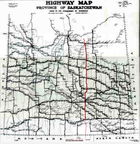
Saskatchewan Highway 6
Encyclopedia
Highway 6 is a paved undivided major provincial highway
in the Canadian
province of Saskatchewan
. It runs from Montana Highway 16 at the Saskatchewan border with the US near the Canada customs port of Regway to Highway 55
near Choiceland
. Highway 6 is about 516.6 km (321 mi) long. The CanAm Highway
comprises Saskatchewan Highways from south to north: SK 35
, Sk 39
, Sk 6, Sk 3
, as well as Sk 2
. 203.1 miles (326.9 km) of Saskatchewan Highway 6 contribute to the CanAm Highway
between Corinne and Melfort
.
Major provincial highways that Highway 6 intersects are Highway 18
, Highway 13 (the Redcoat Trail)
, Highway 39
, Highway 1 (The Trans-Canada)
, Highway 11
, Highway 99
, Highway 22
, Highway 15
, Highway 16 (the Yellowhead)
, Highway 5
, Highway 3
, Highway 41
, and Highway 55
.
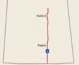
Highway 6 passes through the cities of Regina
and Melfort
.
Highway 6 begins at the Canada – United States border. The border crossings are Raymond, Montana
on Montana Highway 16 in the United States
and at Regway, Saskatchewan on Hwy 6. Two early name choices for Meyer were Meyersville or Fort Comfort the name of the neighboring North-West Mounted Police (NWMP) post to the north. Minton, became a hamlet in 1930 and in 1951 Minton incorporated as a village. The initial stages of the journey are mixed grassland, and the main economy is ranching. This area traversed is the Big Muddy Badlands area of the Missouri Coteau. The terrain of the Missouri Coteau features low hummocky, undulating, rolling hills, potholes, and grasslands. This physiographic region of Saskatchewan is the uplands Missouri Coteau, a part of the Great Plains Province or Alberta Plateau Region which extends across the south east corner of the province of Saskatchewan. There are several unique geographical features
. The Big Muddy Valley, The Hole in the Wall Coulee, Roan Mare Coulee are all deep valleys of the area. The Big Muddy Lake, an alkali lake, could be crossed at the Diamond Crossing was a rise in Big Muddy Lake. Outlaw gangs such as the Jones-Nelson Gang used this undulating landscape to cross the border and hide out. The Big Muddy Lake itself is as are West Coteau and East Coteau lake. Between the Canada customs port of Regway, and Minton are several points of interest such as an old schoolhouse, and the historic Ceylon Park Memorial Garden. Gibson Creek is dammed with Ceylon Dam providing water to the village of Ceylon, as well as the Ceylon Regional Park which is located just off Hwy 6. Besides passing ranches, oil and gas wells, agricultural lands producing feed, there are also Pregnant Mare Urine barns along this route.
Hwy 6 intersects the Red Coat Trail
near Pangman
at Ceylon
.
junction.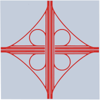 It is here that the northern journey of the CanAm Highway
continues on Sk Hwy 6. Sk Hwy 6 and Sk Hwy 1, the TransCanada Hwy
Cloverleaf interchange
south of Regina
is one of the first two Saskatchewan interchanges which opened in 1967. Regina is the capital of Saskatchewan
and is the second largest in the province (after Saskatoon
). Regina was previously the headquarters of the North-West Territories, of which today's provinces of Saskatchewan and Alberta
originally formed part, and of the District of Assiniboia.
The city is situated on a broad, flat, treeless plain. There is an abundance of parks and greenspaces: all of its trees — some 300,000 — shrubs and other plants were hand-planted and Regina's considerable beauty is entirely man-made. As in other prairie cities, American elm
s were planted in front yards in residential neighbourhoods and on boulevards along major traffic arteries and are the dominant species in the urban forest. The IPSCO Wildlife Park is located off Hwy 6 at Regina
. The Qu'Appelle River
flows east - west across the province, Highway 6 goes through the Qu'Appelle valley north of Regina. A crosswalk was installed at Southey
with overhead lights giving higher visibility to pedestrians crossing Hwy 6 at Assiniboia Avenue.
 In the aspen parkland ecoregion, deer
and other large ungulate
s are a hazard to traffic resulting in potential animal or human deaths especially in the autumn mating months or when deer are searching for feeding grounds in the spring. The defense mechanism of deer in the face of a threat is to freeze. There are over 3,500 deer - auto collisions per year in Saskatchewan. A number of measures have been implemented to increase awareness such as fencing, feeding programs, automobile whistles. Deer mirrors along the edges of highways were installed for reducing deer-vehicle collisions. The Wildlife Warning System is triggered by highway vehicles, setting off lights, sounds and or odours ahead of the approaching vehicle to frighten away animals. A system that detects vehicle was installed in 2002 near Harris
to reduce the quantity of mule deer - automobile accidents for a two year testing period. Another system detects large animals and sets off a warning system to drivers of vehicles alerting them that an animal is on or near the highway ahead of time.
At the Hwy 39
concurrency, Hwy 6 becomes a part of the CanAm Highway
. The historic Wood Mountain - FortQu'Appelle Trail is marked with a point of interest marker. McNab Regional Park is located south of Watson
featuring pool and golf course. Watson is located amid the junction of Hwy 5
and Hwy 6. In this area Hwy 6 is traveling through the boreal-transition ecoregion. The highway travels east of Lake Charron upon which Lake Charron Regional Park offers camping, fishing, nature trails and snowmobiling trailss. Naicam is served by Hwy 6, and Hwy 349
. This area is sustained by agriculture with the ecosystem changing from the rolling parkland to boreal forest. The Barrier river valley, Kipabiskau Regional Park, and Lake Charron Regional Park are nearby features.
, a city of about 6,000, is located on Hwy 6, Hwy 3
, and Sk Hwy 41
. The CanAm Highway continues north on Hwy 3. The South Saskatchewan
and North Saskatchewan River
s join together west of the highway. The highway thus crosses the Saskatchewan River
. The Fort à la Corne Provincial Park and the confluence of the Saskatchewan River Basin are two major attractions in this area. Choiceland is located 1 miles (1.6 km) north of Hwy 55
, the terminus junction of Hwy 6. The rural municipality
of Torch River No. 488
is located past the tree line of Saskatchewan. There are several recreational sites in the area such as Scot's Landing on the Saskatchewan River and Carrolls Cove Campground, Pruden's Point at Tobin Lake.
Highway
A highway is any public road. In American English, the term is common and almost always designates major roads. In British English, the term designates any road open to the public. Any interconnected set of highways can be variously referred to as a "highway system", a "highway network", or a...
in the Canadian
Canada
Canada is a North American country consisting of ten provinces and three territories. Located in the northern part of the continent, it extends from the Atlantic Ocean in the east to the Pacific Ocean in the west, and northward into the Arctic Ocean...
province of Saskatchewan
Saskatchewan
Saskatchewan is a prairie province in Canada, which has an area of . Saskatchewan is bordered on the west by Alberta, on the north by the Northwest Territories, on the east by Manitoba, and on the south by the U.S. states of Montana and North Dakota....
. It runs from Montana Highway 16 at the Saskatchewan border with the US near the Canada customs port of Regway to Highway 55
Saskatchewan Highway 55
Highway 55 is a provincial paved undivided highway in the Canadian province of Saskatchewan. It runs from Alberta Highway 55 near the Alberta border until Highway 9. Highway 55 is 652 km long. It forms part of the interprovincial Northern Woods and Water Route.-Attractions:On the West portion...
near Choiceland
Choiceland, Saskatchewan
-Climate:-External links:...
. Highway 6 is about 516.6 km (321 mi) long. The CanAm Highway
CanAm Highway
CanAm Highway passes through these states in the United States; Texas, New Mexico, Colorado, Wyoming, South Dakota, North Dakota, as well as the province of Saskatchewan, Canada. The international Can-Am Highway travels along U.S. Route 85 and Interstate 25, connecting Mexico to Canada through...
comprises Saskatchewan Highways from south to north: SK 35
Saskatchewan Highway 35
Highway 35 is a paved undivided provincial highway in the Canadian province of Saskatchewan. It runs from the US Border near Port of Oungre to a dead end near the north shore of Tobin Lake. Saskatchewan Highway 35 SK Hwy 35) is about long. The CanAm Highway comprises Saskatchewan Highways 35,...
, Sk 39
Saskatchewan Highway 39
Highway 39 is a provincial paved undivided highway located in the southern portion of the Canadian province of Saskatchewan connecting North Portal and Moose Jaw in the north. This is a primary Saskatchewan highway maintained by the provincial and national governments providing a major trucking...
, Sk 6, Sk 3
Saskatchewan Highway 3
Highway 3 is a major provincial paved undivided highway in the Canadian province of Saskatchewan. It runs from the Alberta border, continues west as Alberta Highway 45 to the Manitoba border, and then continues east as Highway 77. Highway 3 is about 615 km long. The CanAm Highway comprises ...
, as well as Sk 2
Saskatchewan Highway 2
Highway 2 is a provincial highway in the Canadian province of Saskatchewan. It is the longest Saskatchewan Highway, at 809 km . The highway is partially divided and undivided. However, only about near Moose Jaw, near Chamberlain, and near Prince Albert are divided highway...
. 203.1 miles (326.9 km) of Saskatchewan Highway 6 contribute to the CanAm Highway
CanAm Highway
CanAm Highway passes through these states in the United States; Texas, New Mexico, Colorado, Wyoming, South Dakota, North Dakota, as well as the province of Saskatchewan, Canada. The international Can-Am Highway travels along U.S. Route 85 and Interstate 25, connecting Mexico to Canada through...
between Corinne and Melfort
Melfort, Saskatchewan
Melfort is a small Canadian city in Saskatchewan, approximately southeast of Prince Albert, northwest of Saskatoon and north of Regina.According to The World Gazetteer, its population as of 2004 was 5,400...
.
Major provincial highways that Highway 6 intersects are Highway 18
Saskatchewan Highway 18
Highway 18 is a highway in the Canadian province of Saskatchewan. It runs from Highway 13 near Robsart to the Manitoba border near Gainsborough, where it becomes Highway 3. Highway 18 is about 714 km long.-Communities along the route:...
, Highway 13 (the Redcoat Trail)
Saskatchewan Highway 13
Highway 13 is a highway in the Canadian province of Saskatchewan. It runs from the Alberta border until it transitions into Highway 2 at the Manitoba border near Antler. Highway 13 is about 676 km long.Highway 13 passes through Shaunavon, Assiniboia, Weyburn, Redvers and Carlyle...
, Highway 39
Saskatchewan Highway 39
Highway 39 is a provincial paved undivided highway located in the southern portion of the Canadian province of Saskatchewan connecting North Portal and Moose Jaw in the north. This is a primary Saskatchewan highway maintained by the provincial and national governments providing a major trucking...
, Highway 1 (The Trans-Canada)
Saskatchewan Highway 1
Highway 1 is the Saskatchewan section of the Trans-Canada Highway mainland route. The total distance of the Trans-Canada Highway in Saskatchewan is . The highway traverses Saskatchewan from the western border with Alberta, from Highway 1, to Manitoba where it continues as Highway 1, PTH 1. The...
, Highway 11
Saskatchewan Highway 11
Highway 11 is a major north-south highway in Saskatchewan, Canada that connects the province's three largest cities: Regina, Saskatoon and Prince Albert. It is a structural pavement major arterial highway which is approximately long. It is also known as the Louis Riel Trail after the 19th century...
, Highway 99
Saskatchewan Highway 99
Highway 99 is a highway in the Canadian province of Saskatchewan. It runs from Highway 20 near Craven to Highway 6 near Fairy Hill. Highway 99 is about 22 km long.According to MapArt, Highway 99 is entirely unpaved....
, Highway 22
Saskatchewan Highway 22
Highway 22 is a highway in the Canadian province of Saskatchewan connecting Highway 20 near Earl Grey to Provincial Road 478 Manitoba border near Esterhazy.-Communities along the route:*Bulyea*Earl Grey*Southey*Markinch*Cupar*Lipton*Fort San...
, Highway 15
Saskatchewan Highway 15
Highway 15 is a highway in the Canadian province of Saskatchewan. It runs from Highway 4, 5 km south of Rosetown, to Highway 16 near Bredenbury. Highway 15 is about 444 km long. The Outlook Bridge caries Highway 15 across the South Saskatchewan River.Major communities that Highway 15 passes near...
, Highway 16 (the Yellowhead)
Saskatchewan Highway 16
Highway 16 is a provincial paved highway in the Canadian province of Saskatchewan. It is the Saskatchewan section of the Yellowhead Highway, and also the Trans-Canada Highway Yellowhead section. The main purpose of this highway is to connect Saskatchewan with Canadian cities such as Edmonton and...
, Highway 5
Saskatchewan Highway 5
This article focuses on the current designated Saskatchewan Highway 5, for Provincial Highway 5, Evergreen route portion, north west of Saskatoon see Saskatchewan Highway 16....
, Highway 3
Saskatchewan Highway 3
Highway 3 is a major provincial paved undivided highway in the Canadian province of Saskatchewan. It runs from the Alberta border, continues west as Alberta Highway 45 to the Manitoba border, and then continues east as Highway 77. Highway 3 is about 615 km long. The CanAm Highway comprises ...
, Highway 41
Saskatchewan Highway 41
Highway 41 is a highway in the Canadian province of Saskatchewan. It runs from Highway 5 in Saskatoon to Highway 6/Highway 3 in Melfort. Highway 41 is about . long....
, and Highway 55
Saskatchewan Highway 55
Highway 55 is a provincial paved undivided highway in the Canadian province of Saskatchewan. It runs from Alberta Highway 55 near the Alberta border until Highway 9. Highway 55 is 652 km long. It forms part of the interprovincial Northern Woods and Water Route.-Attractions:On the West portion...
.
Highway 6 passes through the cities of Regina
Regina, Saskatchewan
Regina is the capital city of the Canadian province of Saskatchewan. The city is the second-largest in the province and a cultural and commercial centre for southern Saskatchewan. It is governed by Regina City Council. Regina is the cathedral city of the Roman Catholic and Romanian Orthodox...
and Melfort
Melfort, Saskatchewan
Melfort is a small Canadian city in Saskatchewan, approximately southeast of Prince Albert, northwest of Saskatoon and north of Regina.According to The World Gazetteer, its population as of 2004 was 5,400...
.
Canada - United States border to Corinne
| Communities |
|---|
|
Highway 6 begins at the Canada – United States border. The border crossings are Raymond, Montana
Raymond, Montana
Raymond is an unincorporated community in Sheridan County, Montana, United States, north of Plentywood....
on Montana Highway 16 in the United States
United States
The United States of America is a federal constitutional republic comprising fifty states and a federal district...
and at Regway, Saskatchewan on Hwy 6. Two early name choices for Meyer were Meyersville or Fort Comfort the name of the neighboring North-West Mounted Police (NWMP) post to the north. Minton, became a hamlet in 1930 and in 1951 Minton incorporated as a village. The initial stages of the journey are mixed grassland, and the main economy is ranching. This area traversed is the Big Muddy Badlands area of the Missouri Coteau. The terrain of the Missouri Coteau features low hummocky, undulating, rolling hills, potholes, and grasslands. This physiographic region of Saskatchewan is the uplands Missouri Coteau, a part of the Great Plains Province or Alberta Plateau Region which extends across the south east corner of the province of Saskatchewan. There are several unique geographical features
Geography of Saskatchewan
The geography of Saskatchewan , is unique among the provinces and territories of Canada in some respects. It is one of only two landlocked regions and it is the only region whose borders are not based on natural features like lakes, rivers or drainage divides...
. The Big Muddy Valley, The Hole in the Wall Coulee, Roan Mare Coulee are all deep valleys of the area. The Big Muddy Lake, an alkali lake, could be crossed at the Diamond Crossing was a rise in Big Muddy Lake. Outlaw gangs such as the Jones-Nelson Gang used this undulating landscape to cross the border and hide out. The Big Muddy Lake itself is as are West Coteau and East Coteau lake. Between the Canada customs port of Regway, and Minton are several points of interest such as an old schoolhouse, and the historic Ceylon Park Memorial Garden. Gibson Creek is dammed with Ceylon Dam providing water to the village of Ceylon, as well as the Ceylon Regional Park which is located just off Hwy 6. Besides passing ranches, oil and gas wells, agricultural lands producing feed, there are also Pregnant Mare Urine barns along this route.
Hwy 6 intersects the Red Coat Trail
Saskatchewan Highway 13
Highway 13 is a highway in the Canadian province of Saskatchewan. It runs from the Alberta border until it transitions into Highway 2 at the Manitoba border near Antler. Highway 13 is about 676 km long.Highway 13 passes through Shaunavon, Assiniboia, Weyburn, Redvers and Carlyle...
near Pangman
Pangman, Saskatchewan
Pangman, formerly known as West Calder, is a village located in southern Saskatchewan, Canada; it is south of Regina. Pangman has a population of 255 and land area of 0.73 square kilometres .-Education:...
at Ceylon
Ceylon, Saskatchewan
Ceylon is a community in Saskatchewan. A few kilometres to the east of Ceylon, there are sand dunes.-Climate:-References:...
.
Highway 6 section of CanAm Highway begins
Corinne is located at the Sk Hwy 6 and Sk Hwy 39Saskatchewan Highway 39
Highway 39 is a provincial paved undivided highway located in the southern portion of the Canadian province of Saskatchewan connecting North Portal and Moose Jaw in the north. This is a primary Saskatchewan highway maintained by the provincial and national governments providing a major trucking...
junction.
CanAm Highway
CanAm Highway passes through these states in the United States; Texas, New Mexico, Colorado, Wyoming, South Dakota, North Dakota, as well as the province of Saskatchewan, Canada. The international Can-Am Highway travels along U.S. Route 85 and Interstate 25, connecting Mexico to Canada through...
continues on Sk Hwy 6. Sk Hwy 6 and Sk Hwy 1, the TransCanada Hwy
Saskatchewan Highway 1
Highway 1 is the Saskatchewan section of the Trans-Canada Highway mainland route. The total distance of the Trans-Canada Highway in Saskatchewan is . The highway traverses Saskatchewan from the western border with Alberta, from Highway 1, to Manitoba where it continues as Highway 1, PTH 1. The...
Cloverleaf interchange
Cloverleaf interchange
A cloverleaf interchange is a two-level interchange in which left turns, reverse direction in left-driving regions, are handled by ramp roads...
south of Regina
Regina, Saskatchewan
Regina is the capital city of the Canadian province of Saskatchewan. The city is the second-largest in the province and a cultural and commercial centre for southern Saskatchewan. It is governed by Regina City Council. Regina is the cathedral city of the Roman Catholic and Romanian Orthodox...
is one of the first two Saskatchewan interchanges which opened in 1967. Regina is the capital of Saskatchewan
Saskatchewan
Saskatchewan is a prairie province in Canada, which has an area of . Saskatchewan is bordered on the west by Alberta, on the north by the Northwest Territories, on the east by Manitoba, and on the south by the U.S. states of Montana and North Dakota....
and is the second largest in the province (after Saskatoon
Saskatoon
Saskatoon is a city in central Saskatchewan, Canada, on the South Saskatchewan River. Residents of the city of Saskatoon are called Saskatonians. The city is surrounded by the Rural Municipality of Corman Park No. 344....
). Regina was previously the headquarters of the North-West Territories, of which today's provinces of Saskatchewan and Alberta
Alberta
Alberta is a province of Canada. It had an estimated population of 3.7 million in 2010 making it the most populous of Canada's three prairie provinces...
originally formed part, and of the District of Assiniboia.
The city is situated on a broad, flat, treeless plain. There is an abundance of parks and greenspaces: all of its trees — some 300,000 — shrubs and other plants were hand-planted and Regina's considerable beauty is entirely man-made. As in other prairie cities, American elm
American Elm
Ulmus americana, generally known as the American Elm or, less commonly, as the White Elm or Water Elm, is a species native to eastern North America, occurring from Nova Scotia west to Alberta and Montana, and south to Florida and central Texas. The American elm is an extremely hardy tree that can...
s were planted in front yards in residential neighbourhoods and on boulevards along major traffic arteries and are the dominant species in the urban forest. The IPSCO Wildlife Park is located off Hwy 6 at Regina
Regina, Saskatchewan
Regina is the capital city of the Canadian province of Saskatchewan. The city is the second-largest in the province and a cultural and commercial centre for southern Saskatchewan. It is governed by Regina City Council. Regina is the cathedral city of the Roman Catholic and Romanian Orthodox...
. The Qu'Appelle River
Qu'Appelle River
The Qu'Appelle River is a Canadian river that flows 430 km east from Lake Diefenbaker in southwestern Saskatchewan to join the Assiniboine River in Manitoba, just south of Lake of the Prairies, near the village of St. Lazare....
flows east - west across the province, Highway 6 goes through the Qu'Appelle valley north of Regina. A crosswalk was installed at Southey
Southey, Saskatchewan
Southey is a town in Saskatchewan, Canada. It is located on Highway #6, 55 km. north of Regina, Saskatchewan, the capital city of the province of Saskatchewan.Southey is named after a famous English poet, Robert Southey...
with overhead lights giving higher visibility to pedestrians crossing Hwy 6 at Assiniboia Avenue.
Fauna of Saskatchewan
The Fauna of Saskatchewan include several diverse land and aquatic animal species. From the multiplicity of invertebrates and vertebrates, two have been chosen as symbols of Saskatchewan. Cenozoic vertebrate fossils reveal the geological evolution of the interior plains and its prehistoric...
and other large ungulate
Ungulate
Ungulates are several groups of mammals, most of which use the tips of their toes, usually hoofed, to sustain their whole body weight while moving. They make up several orders of mammals, of which six to eight survive...
s are a hazard to traffic resulting in potential animal or human deaths especially in the autumn mating months or when deer are searching for feeding grounds in the spring. The defense mechanism of deer in the face of a threat is to freeze. There are over 3,500 deer - auto collisions per year in Saskatchewan. A number of measures have been implemented to increase awareness such as fencing, feeding programs, automobile whistles. Deer mirrors along the edges of highways were installed for reducing deer-vehicle collisions. The Wildlife Warning System is triggered by highway vehicles, setting off lights, sounds and or odours ahead of the approaching vehicle to frighten away animals. A system that detects vehicle was installed in 2002 near Harris
Harris, Saskatchewan
-Climate:- See also :* List of communities in Saskatchewan* Villages of Saskatchewan-External links:**-Footnotes:...
to reduce the quantity of mule deer - automobile accidents for a two year testing period. Another system detects large animals and sets off a warning system to drivers of vehicles alerting them that an animal is on or near the highway ahead of time.
At the Hwy 39
Saskatchewan Highway 39
Highway 39 is a provincial paved undivided highway located in the southern portion of the Canadian province of Saskatchewan connecting North Portal and Moose Jaw in the north. This is a primary Saskatchewan highway maintained by the provincial and national governments providing a major trucking...
concurrency, Hwy 6 becomes a part of the CanAm Highway
CanAm Highway
CanAm Highway passes through these states in the United States; Texas, New Mexico, Colorado, Wyoming, South Dakota, North Dakota, as well as the province of Saskatchewan, Canada. The international Can-Am Highway travels along U.S. Route 85 and Interstate 25, connecting Mexico to Canada through...
. The historic Wood Mountain - FortQu'Appelle Trail is marked with a point of interest marker. McNab Regional Park is located south of Watson
Watson, Saskatchewan
-History:Settlers began arriving in the early 1900s, many of them German American Catholics. The first post office in the area was established on April 1, 1904 and named named Vossen after its postmaster, Frank J. Vossen Jr. It was changed to Watson on May 1, 1906, in advance of the village's...
featuring pool and golf course. Watson is located amid the junction of Hwy 5
Saskatchewan Highway 5
This article focuses on the current designated Saskatchewan Highway 5, for Provincial Highway 5, Evergreen route portion, north west of Saskatoon see Saskatchewan Highway 16....
and Hwy 6. In this area Hwy 6 is traveling through the boreal-transition ecoregion. The highway travels east of Lake Charron upon which Lake Charron Regional Park offers camping, fishing, nature trails and snowmobiling trailss. Naicam is served by Hwy 6, and Hwy 349
Saskatchewan Highway 349
Highway 349 is a highway in the Canadian province of Saskatchewan. It runs from Highway 6 near Naicam to Highway 38. Highway 349 is about 69 km long....
. This area is sustained by agriculture with the ecosystem changing from the rolling parkland to boreal forest. The Barrier river valley, Kipabiskau Regional Park, and Lake Charron Regional Park are nearby features.
Highway 6 section of CanAmHighway ends
MelfortMelfort, Saskatchewan
Melfort is a small Canadian city in Saskatchewan, approximately southeast of Prince Albert, northwest of Saskatoon and north of Regina.According to The World Gazetteer, its population as of 2004 was 5,400...
, a city of about 6,000, is located on Hwy 6, Hwy 3
Saskatchewan Highway 3
Highway 3 is a major provincial paved undivided highway in the Canadian province of Saskatchewan. It runs from the Alberta border, continues west as Alberta Highway 45 to the Manitoba border, and then continues east as Highway 77. Highway 3 is about 615 km long. The CanAm Highway comprises ...
, and Sk Hwy 41
Saskatchewan Highway 41
Highway 41 is a highway in the Canadian province of Saskatchewan. It runs from Highway 5 in Saskatoon to Highway 6/Highway 3 in Melfort. Highway 41 is about . long....
. The CanAm Highway continues north on Hwy 3. The South Saskatchewan
South Saskatchewan River
The South Saskatchewan River is a major river in Canada that flows through the provinces of Alberta and Saskatchewan....
and North Saskatchewan River
North Saskatchewan River
The North Saskatchewan River is a glacier-fed river that flows east from the Canadian Rockies to central Saskatchewan. It is one of two major rivers that join to make up the Saskatchewan River....
s join together west of the highway. The highway thus crosses the Saskatchewan River
Saskatchewan River
The Saskatchewan River is a major river in Canada, approximately long, flowing roughly eastward across Saskatchewan and Manitoba to empty into Lake Winnipeg...
. The Fort à la Corne Provincial Park and the confluence of the Saskatchewan River Basin are two major attractions in this area. Choiceland is located 1 miles (1.6 km) north of Hwy 55
Saskatchewan Highway 55
Highway 55 is a provincial paved undivided highway in the Canadian province of Saskatchewan. It runs from Alberta Highway 55 near the Alberta border until Highway 9. Highway 55 is 652 km long. It forms part of the interprovincial Northern Woods and Water Route.-Attractions:On the West portion...
, the terminus junction of Hwy 6. The rural municipality
Rural municipality
A rural municipality, often abbreviated RM, is a form of municipality in the Canadian provinces of Manitoba and Saskatchewan, perhaps best comparable to counties or townships in the western United States...
of Torch River No. 488
Torch River No. 488, Saskatchewan
Torch River No. 488, Saskatchewan is a rural municipality in north eastern Saskatchewan. It is located northwest of the town of Nipawin. Within the geographical borders of the rural municipality lie the separately governed communities of Choiceland, Love, Smeaton, and White Fox, none of which is...
is located past the tree line of Saskatchewan. There are several recreational sites in the area such as Scot's Landing on the Saskatchewan River and Carrolls Cove Campground, Pruden's Point at Tobin Lake.
History
In 1999 the asphalt concrete pavement section of Highway 6 north of Raymore was tested with a Cold in-place recycling or “CIR” method to rehabilitate highways. This CIR process is a cost effective method which recycles the top surface of a road. This pulvarized material is mixed with asphalt emulsion and spread and compacted back onto the highway surface. This surface is then recovered with a new seal dependant on traffic volume.Intersections from south to north
Extra reading
- Title Golden leaves / Minton Homesteading in Surprise Valley 1980" Book Committee. [S.l.] : Minton "1980" Book Committee, 1980. Minton "1980" Book Committee
- Title Builders of a great land. Published Ceylon, Sask. : History Committee of R.M. of The Gap # 39, 1980. ISBN 0889250820.
- Title Homesteading in Surprise Valley; an autobiographical account of the pioneers in this district, compiled by Alice Henderson and Mrs. Nick Stefan.
- Title Builders of a great land continues : R.M. of The Gap #39, Ceylon ISBN 1550568590.
- Title From the roughbark to the buttes : R.M. Norton, no. 69, villages of Amulet, Forward, Khedive, Moreland and Pangman. R.M. of Norton History Committee. ISBN 0889251444.
- Title Update 95 : R.M. of Norton #69 : Pangman, Moreland, Khedive, Forward, Amulet. Published Pangman, Sask. : R.M. of Norton History Committee, c1998. ISBN 1550565125.
- Title Southey seen. Published Southey, SK : [s.n.], 1965. Southey High School.
- Title From prairie wool to golden grain : Raymore and district, 1904-1979. Published Raymore, Sask. : Raymore and District Historical Society, c1980
- Title Harvest of memories : Earl Grey and district. Published Earl Grey, SK : Earl Grey History Committee, 2007. ISBN 9781553831761 (bound) 1553831764 (bound)
- Title Longlaketon [microform] / [A.S.R.] Published [S.l. : s.n., 1893?]Institute for Historical Microreproductions, 1981. 1 microfiche (6 fr.) ISBN 0665150474 (Positive copy)
- Title Seventy five years of rural municipal government / by B.M. Sali. Sali, B. M. Published [Markinch, Sask.] : Published by Rural Municipality of Cupar No. 218, [1985?].
- Title Watson, Saskatchewan : photographs and posters Published [Watson, SK : s.n. ; 19—?]
- Title Fifty years of progress : chiefly the story of the pioneers of the Watson district from 1900-1910 / edited by Ben Putnam .. [et al.] Muenster, Sask. : St. Peter's Press, [1951?]
- Title A century of progress : Watson and district. Published Watson, Sask. : Watson History Book Committee, c2003. ISBN 1550569449
- Title Prairie Rose memories Published Jansen, Sask. : Prairie Rose Historical Society, 1992. ISBN 1550560085
- Title Spalding roots and branches Spalding, Sask. : Spalding & District Historical Society, 1981. ISBN 0889252351
- Title Gleanings along the way : a history of Naicam, Lac Vert and surrounding districts / [Naicam Heritage Committee] ; cover design by Norah Pederson ; inside liners by Leslie Amundson ; sketches by Crystal Misfeldt. Published Winnipeg, Man. : Inter-Collegiate Press, 1980
- Title Voices of the past : a history of Melfort and district. Author Ryan, Timothy. Published Melfort : Melfort and District Golden Jubliee Committee, 1955
- Title Log cabin tales and changing trails : history of Choiceland and district. Published Choiceland, Sask. : Choiceland Historical Society, 1984. ISBN 0889254591
- Title Kinistino : the story of a parkland community in central Saskatchewan, in two parts. Published [Kinistino? Sask.] : Kinistino and District Historical Organization, 1980. Armstrong, Jerrold
- Title R.M. of Willow Creek No. 458 : jubilee year, 1912-1962. Author Kahn, Fannie H. Hoffer. Published Melfort, Sask. : Melfort Journal Press, 1962
External links
- Can Am Highway Saskatchewan Tourism
- Sask Biz Community Profiles
- Encyclopedia of Saskatchewan
- Sask Biz Norton No. 69
- Sask Biz Caledonia No. 99
- Sask Biz Southey
- Sask Biz Rural Municipality (RM) of Lumsden
- Sask Biz Raymore
- Sask Biz Cupar
- Sask Biz Watson
- Sask Biz Prairie Rose
- Sask Biz Naicam
- Sask Biz Melfort
- Sask Biz Choiceland
- Saskatchewan 1926 Highway Map