
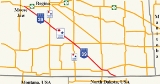
Saskatchewan Highway 39
Encyclopedia

Highway
A highway is any public road. In American English, the term is common and almost always designates major roads. In British English, the term designates any road open to the public. Any interconnected set of highways can be variously referred to as a "highway system", a "highway network", or a...
located in the southern portion of the Canadian
Canada
Canada is a North American country consisting of ten provinces and three territories. Located in the northern part of the continent, it extends from the Atlantic Ocean in the east to the Pacific Ocean in the west, and northward into the Arctic Ocean...
province of Saskatchewan
Saskatchewan
Saskatchewan is a prairie province in Canada, which has an area of . Saskatchewan is bordered on the west by Alberta, on the north by the Northwest Territories, on the east by Manitoba, and on the south by the U.S. states of Montana and North Dakota....
connecting North Portal
North Portal, Saskatchewan
-External links:********-Footnotes:...
and Moose Jaw
Moose Jaw, Saskatchewan
Moose Jaw is a city in south-central Saskatchewan, Canada on the Moose Jaw River. It is situated on the Trans-Canada Highway, west of Regina. Residents of Moose Jaw are known as Moose Javians. It is best known as a retirement and tourist city that serves as a hub to the hundreds of small towns...
in the north. This is a primary Saskatchewan
Saskatchewan
Saskatchewan is a prairie province in Canada, which has an area of . Saskatchewan is bordered on the west by Alberta, on the north by the Northwest Territories, on the east by Manitoba, and on the south by the U.S. states of Montana and North Dakota....
highway
Highway
A highway is any public road. In American English, the term is common and almost always designates major roads. In British English, the term designates any road open to the public. Any interconnected set of highways can be variously referred to as a "highway system", a "highway network", or a...
maintained by the provincial and national governments providing a major trucking and tourism route between the United States via Portal, Burke county, North Dakota, U.S.A. and North Portal, Saskatchewan
North Portal, Saskatchewan
-External links:********-Footnotes:...
. On July 3, 2000, Highways and Transportation Minister Maynard Sonntag officiated at the ribbon cutting ceremony opening the new Duty Free Shop and the twinned highway
Dual carriageway
A dual carriageway is a class of highway with two carriageways for traffic travelling in opposite directions separated by a central reservation...
at Saskatchewan's busiest border crossing. Highway 39 is one of Canada's busiest highways, facilitating transport for C$6 billion in trade goods via approximately 100,000 trucks over the year. U.S. Route 52
U.S. Route 52
U.S. Route 52 is a United States highway that runs across the northern, eastern and southeastern regions of the United States. Contrary to most other even-numbered U.S...
connects North Dakota
North Dakota
North Dakota is a state located in the Midwestern region of the United States of America, along the Canadian border. The state is bordered by Canada to the north, Minnesota to the east, South Dakota to the south and Montana to the west. North Dakota is the 19th-largest state by area in the U.S....
, Minnesota
Minnesota
Minnesota is a U.S. state located in the Midwestern United States. The twelfth largest state of the U.S., it is the twenty-first most populous, with 5.3 million residents. Minnesota was carved out of the eastern half of the Minnesota Territory and admitted to the Union as the thirty-second state...
, Iowa
Iowa
Iowa is a state located in the Midwestern United States, an area often referred to as the "American Heartland". It derives its name from the Ioway people, one of the many American Indian tribes that occupied the state at the time of European exploration. Iowa was a part of the French colony of New...
, Illinois
Illinois
Illinois is the fifth-most populous state of the United States of America, and is often noted for being a microcosm of the entire country. With Chicago in the northeast, small industrial cities and great agricultural productivity in central and northern Illinois, and natural resources like coal,...
, Indiana
Indiana
Indiana is a US state, admitted to the United States as the 19th on December 11, 1816. It is located in the Midwestern United States and Great Lakes Region. With 6,483,802 residents, the state is ranked 15th in population and 16th in population density. Indiana is ranked 38th in land area and is...
, Ohio
Ohio
Ohio is a Midwestern state in the United States. The 34th largest state by area in the U.S.,it is the 7th‑most populous with over 11.5 million residents, containing several major American cities and seven metropolitan areas with populations of 500,000 or more.The state's capital is Columbus...
, Kentucky
Kentucky
The Commonwealth of Kentucky is a state located in the East Central United States of America. As classified by the United States Census Bureau, Kentucky is a Southern state, more specifically in the East South Central region. Kentucky is one of four U.S. states constituted as a commonwealth...
, West Virginia
West Virginia
West Virginia is a state in the Appalachian and Southeastern regions of the United States, bordered by Virginia to the southeast, Kentucky to the southwest, Ohio to the northwest, Pennsylvania to the northeast and Maryland to the east...
, Virginia
Virginia
The Commonwealth of Virginia , is a U.S. state on the Atlantic Coast of the Southern United States. Virginia is nicknamed the "Old Dominion" and sometimes the "Mother of Presidents" after the eight U.S. presidents born there...
, North Carolina
North Carolina
North Carolina is a state located in the southeastern United States. The state borders South Carolina and Georgia to the south, Tennessee to the west and Virginia to the north. North Carolina contains 100 counties. Its capital is Raleigh, and its largest city is Charlotte...
, and South Carolina
South Carolina
South Carolina is a state in the Deep South of the United States that borders Georgia to the south, North Carolina to the north, and the Atlantic Ocean to the east. Originally part of the Province of Carolina, the Province of South Carolina was one of the 13 colonies that declared independence...
. All of highway 39 is paved. The CanAm Highway
CanAm Highway
CanAm Highway passes through these states in the United States; Texas, New Mexico, Colorado, Wyoming, South Dakota, North Dakota, as well as the province of Saskatchewan, Canada. The international Can-Am Highway travels along U.S. Route 85 and Interstate 25, connecting Mexico to Canada through...
comprises Saskatchewan Highways Hwy 35
Saskatchewan Highway 35
Highway 35 is a paved undivided provincial highway in the Canadian province of Saskatchewan. It runs from the US Border near Port of Oungre to a dead end near the north shore of Tobin Lake. Saskatchewan Highway 35 SK Hwy 35) is about long. The CanAm Highway comprises Saskatchewan Highways 35,...
, Hwy 39, Hwy 6
Saskatchewan Highway 6
Highway 6 is a paved undivided major provincial highway in the Canadian province of Saskatchewan. It runs from Montana Highway 16 at the Saskatchewan border with the US near the Canada customs port of Regway to Highway 55 near Choiceland. Highway 6 is about long. The CanAm Highway comprises ...
, Hwy 3
Saskatchewan Highway 3
Highway 3 is a major provincial paved undivided highway in the Canadian province of Saskatchewan. It runs from the Alberta border, continues west as Alberta Highway 45 to the Manitoba border, and then continues east as Highway 77. Highway 3 is about 615 km long. The CanAm Highway comprises ...
, as well as Hwy 2
Saskatchewan Highway 2
Highway 2 is a provincial highway in the Canadian province of Saskatchewan. It is the longest Saskatchewan Highway, at 809 km . The highway is partially divided and undivided. However, only about near Moose Jaw, near Chamberlain, and near Prince Albert are divided highway...
. 44.3 miles (71.3 km) of Saskatchewan Highway 39 contribute to the CanAm Highway
CanAm Highway
CanAm Highway passes through these states in the United States; Texas, New Mexico, Colorado, Wyoming, South Dakota, North Dakota, as well as the province of Saskatchewan, Canada. The international Can-Am Highway travels along U.S. Route 85 and Interstate 25, connecting Mexico to Canada through...
between Weyburn
Weyburn, Saskatchewan
Weyburn is a city in southeastern Saskatchewan, Canada. It is located on the Souris River southeast of the provincial capital of Regina and is north of the border with the United States. The name is reputedly a corruption of the Scottish "wee burn," referring to a small creek. The city is...
and Corinne. Highway 39 is divided
Dual carriageway
A dual carriageway is a class of highway with two carriageways for traffic travelling in opposite directions separated by a central reservation...
or twinned in two areas at North Portal
North Portal, Saskatchewan
-External links:********-Footnotes:...
as well as north of Weyburn
Weyburn, Saskatchewan
Weyburn is a city in southeastern Saskatchewan, Canada. It is located on the Souris River southeast of the provincial capital of Regina and is north of the border with the United States. The name is reputedly a corruption of the Scottish "wee burn," referring to a small creek. The city is...
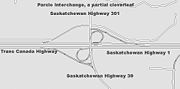
for 1.7 kilometres (1.1 mi). The junction of Hwy 39 with the Trans–Canada
Saskatchewan Highway 1
Highway 1 is the Saskatchewan section of the Trans-Canada Highway mainland route. The total distance of the Trans-Canada Highway in Saskatchewan is . The highway traverses Saskatchewan from the western border with Alberta, from Highway 1, to Manitoba where it continues as Highway 1, PTH 1. The...
divided four lane highway is done via a "Parclo" or partial cloverleaf interchange.
Travel route
Starting in the southeast is North PortalNorth Portal, Saskatchewan
-External links:********-Footnotes:...
or the Port of North Portal customs which is the province's only duty-free shop. The Canada Border Services Agency (CBSA) offers the Courier Low Value Shipments Program (CLVS), Electronic Data Interchange (EDI), Free and Secure Trade (FAST) and Immigration (IMM) services. It is a Designated Commercial Office (DCO), Designated Export Office (EXPORT), Duty-Free Shop (SHOP), Highway - Land Border Office (HWY/B) and Railway Depot (RAIL). Coalfields No. 4
Coalfields No. 4, Saskatchewan
Coalfields No. 4 is a rural municipality in the Canadian province of Saskatchewan. It is located in southeastern Saskatchewan and is within SARM Division No. 1 and Census Division No. 1. Its population was 396 as of the 2006 Census.-Statistics:...
rural municipality
Rural municipality
A rural municipality, often abbreviated RM, is a form of municipality in the Canadian provinces of Manitoba and Saskatchewan, perhaps best comparable to counties or townships in the western United States...
is dependent upon its grazing lands, oil wells and coal mining. The land on either side of the Souris River
Souris River
The Souris River or Mouse River is a river in central North America. It is about 700 km in length and drains about . It rises in the Yellow Grass Marshes north of Weyburn, Saskatchewan...
is too stony for agricultural purposes. The little hamlet of Pinto comprises post office and rail siding. Roche Percée, an unorganized area is named after a geophysical feature of the area. Short Creek Cairn is near the Roche Percee turn off from Highway 39. Located just off of Sk Hwy 39, are two arches created by limestone rocks upon which historic animals, and initials are carved. The local first nation found this site to be a power centre. This Short Creek Cairn is also a resting place for the North-West Mounted Police in 1874 on the Great March West. Henri Julien of the NWMP ride wrote in 1874, that the base was and about high. Although the underground coal mines which lined the Souris River valley have closed, there are two large dragline surface coal mines still operating supplementing agricultural income for residents of Bienfait
Bienfait, Saskatchewan
- See also :* List of communities in SaskatchewanThe town of Bienfait was incorporated as the Village of Bienfait on April 16, 1912 becoming a town on March 1, 1957...
and Roche Percée
Roche Percee, Saskatchewan
-References:...
.
Estevan, Saskatchewan
Estevan is the eighth largest city in Saskatchewan, Canada. It is located at , which is near the southeastern corner of the province. The Souris River runs by the city. The city is surrounded by the Rural Municipality of Estevan No. 5.-History:...
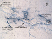
, the power center and eighth largest city of Saskatchewan offers tours of the Rafferty Dam, Boundary Dam Power Station
Boundary Dam Power Station
Boundary Dam Power Station is the largest coal fired station owned by SaskPower, located near Estevan, Saskatchewan, Canada.- Description :The Boundary Dam Power Station consists of :*two 62 net MW units...
, Boundary Dam Mine, the Shand Power Station
Shand Power Station
Shand Power Station is a coal fired station owned by SaskPower, located near Estevan, Saskatchewan, Canada.- Description :The Shand Power Station consists of :*one 279 net MW unit...
and Shand Greenhouse. The city of Estevan is nicknamed Saskatchewan's Energy Capital, as it is provided with coal, natural gas, and oil resources. Prairie Mines & Royalty Ltd. (PMRL) operates the two large coal mines, The Boundary Dam Mine and Bienfait Mine supplying 6.1 million cubic tons of coal to the Shand Power Station and Boundary Dam Power Station. Estevan Heritage Walking Tour and the Historic Driving Tour through the Souris Valley brochures are both available at the Saskatchewan Visitor Information booth. Woodlawn Regional Park features the Souris Valley Theatre which puts on live plays.
Weyburn
Weyburn, Saskatchewan
Weyburn is a city in southeastern Saskatchewan, Canada. It is located on the Souris River southeast of the provincial capital of Regina and is north of the border with the United States. The name is reputedly a corruption of the Scottish "wee burn," referring to a small creek. The city is...
, the opportunity city, has also been dubbed the Soo Line City due its connection with Chicago
Chicago
Chicago is the largest city in the US state of Illinois. With nearly 2.7 million residents, it is the most populous city in the Midwestern United States and the third most populous in the US, after New York City and Los Angeles...
on the Soo Line of the Canadian Pacific Railway CPR
Canadian Pacific Railway
The Canadian Pacific Railway , formerly also known as CP Rail between 1968 and 1996, is a historic Canadian Class I railway founded in 1881 and now operated by Canadian Pacific Railway Limited, which began operations as legal owner in a corporate restructuring in 2001...
. The city of 9,433 people is situated on Sk Hwy 35
Saskatchewan Highway 35
Highway 35 is a paved undivided provincial highway in the Canadian province of Saskatchewan. It runs from the US Border near Port of Oungre to a dead end near the north shore of Tobin Lake. Saskatchewan Highway 35 SK Hwy 35) is about long. The CanAm Highway comprises Saskatchewan Highways 35,...
, Sk Hwy 39, and Sk Hwy 13
Saskatchewan Highway 13
Highway 13 is a highway in the Canadian province of Saskatchewan. It runs from the Alberta border until it transitions into Highway 2 at the Manitoba border near Antler. Highway 13 is about 676 km long.Highway 13 passes through Shaunavon, Assiniboia, Weyburn, Redvers and Carlyle...
. The small towns of Exon and Converge have been absorbed into the city of Weyburn today. The Pasqua branch or the Souris, Arcola, Weyburn, Regina CPR
Canadian Pacific Railway
The Canadian Pacific Railway , formerly also known as CP Rail between 1968 and 1996, is a historic Canadian Class I railway founded in 1881 and now operated by Canadian Pacific Railway Limited, which began operations as legal owner in a corporate restructuring in 2001...
branch, Portal Section CPR
Canadian Pacific Railway
The Canadian Pacific Railway , formerly also known as CP Rail between 1968 and 1996, is a historic Canadian Class I railway founded in 1881 and now operated by Canadian Pacific Railway Limited, which began operations as legal owner in a corporate restructuring in 2001...
on the Soo Line, Moose Jaw, Weyburn, Shaunavon, Lethbridge section CPR
Canadian Pacific Railway
The Canadian Pacific Railway , formerly also known as CP Rail between 1968 and 1996, is a historic Canadian Class I railway founded in 1881 and now operated by Canadian Pacific Railway Limited, which began operations as legal owner in a corporate restructuring in 2001...
, The Brandon, Marfield, Carlyle, Lampman, Radville, Willow Bunch sectionCNR
Canadian National Railway
The Canadian National Railway Company is a Canadian Class I railway headquartered in Montreal, Quebec. CN's slogan is "North America's Railroad"....
, and the Regina, Weyburn, Radville, Estevan, Northgate section CNR
Canadian National Railway
The Canadian National Railway Company is a Canadian Class I railway headquartered in Montreal, Quebec. CN's slogan is "North America's Railroad"....
have all run through Weyburn. Weyburn is located astride the Williston geological Basin which contains oil deposits, and several wells operate in the vicinity. Weyburn features roadside attractions of a large Lighthouse Water Tower, Wheat sheaves and Prairie Lily. Weyburn is situated near the upper delta of the 470 miles (756.4 km) long Souris River. The Souris River continues southeast through North Dakota eventually meeting the Assiniboine River in Manitoba. In the 1800s this area was known as an extension of the Greater Yellow Grass Marsh. "Extensive flood control programs have created reservoirs, parks and waterfowl centres along the Souris River." Between 1988 to 1995, the Rafferty-Alameda Project was constructed to alleviate spring flooding problems created by the Souris River.
Rouleau
Rouleau, Saskatchewan
-Location:-External links:*** Encyclopedia of Saskatchewan...
was the host town for the popular Canadian sitcom, Corner Gas
Corner Gas
Corner Gas is a Canadian television sitcom created by Brent Butt. The series ran for six seasons from 2004 to 2009. Re-runs still air on CTV and The Comedy Network in Canada; it formerly aired on WGN America in the United States....
, which is airing its final season in Canada. The show was set in the fictional town of Dog River, Saskatchewan
Saskatchewan
Saskatchewan is a prairie province in Canada, which has an area of . Saskatchewan is bordered on the west by Alberta, on the north by the Northwest Territories, on the east by Manitoba, and on the south by the U.S. states of Montana and North Dakota....
.
Near the northern terminus is Moose Jaw
Moose Jaw, Saskatchewan
Moose Jaw is a city in south-central Saskatchewan, Canada on the Moose Jaw River. It is situated on the Trans-Canada Highway, west of Regina. Residents of Moose Jaw are known as Moose Javians. It is best known as a retirement and tourist city that serves as a hub to the hundreds of small towns...
, also called "Little Chicago". Moose Jaw, is a city of 32,132 at the Sk Hwy 1 Trans–Canada
Saskatchewan Highway 1
Highway 1 is the Saskatchewan section of the Trans-Canada Highway mainland route. The total distance of the Trans-Canada Highway in Saskatchewan is . The highway traverses Saskatchewan from the western border with Alberta, from Highway 1, to Manitoba where it continues as Highway 1, PTH 1. The...
and Sk Hwy 2
Saskatchewan Highway 2
Highway 2 is a provincial highway in the Canadian province of Saskatchewan. It is the longest Saskatchewan Highway, at 809 km . The highway is partially divided and undivided. However, only about near Moose Jaw, near Chamberlain, and near Prince Albert are divided highway...
intersection. Capone's Car, Moose Family and Mac the Moose are all large roadside attractions of Moose Jaw
Moose Jaw, Saskatchewan
Moose Jaw is a city in south-central Saskatchewan, Canada on the Moose Jaw River. It is situated on the Trans-Canada Highway, west of Regina. Residents of Moose Jaw are known as Moose Javians. It is best known as a retirement and tourist city that serves as a hub to the hundreds of small towns...
. Moose Jaw Trolley Company (1912) is still an operating electric cable trolleys offering tours of Moose Jaw
Moose Jaw, Saskatchewan
Moose Jaw is a city in south-central Saskatchewan, Canada on the Moose Jaw River. It is situated on the Trans-Canada Highway, west of Regina. Residents of Moose Jaw are known as Moose Javians. It is best known as a retirement and tourist city that serves as a hub to the hundreds of small towns...
. Temple Gardens Mineral Spa Resort
Temple Gardens Mineral Spa Resort
The Temple Gardens Mineral Spa Resort is a 4 star , hotel located in downtown Moose Jaw, Saskatchewan, Canada. The resort features a roof top indoor/outdoor mineral pools, and is connected to Casino Moose Jaw. In 1910, drillers looking for oil hit the hot springs that service the hotel, remains...
, Tunnels of Moose Jaw, and History of Transportation Western Development Museum. are major sites of interest of this city. The juncture of Moose Jaw and Thunder Creek produced the best source of water for steam engines, and Moose Jaw became the CPR
Canadian Pacific Railway
The Canadian Pacific Railway , formerly also known as CP Rail between 1968 and 1996, is a historic Canadian Class I railway founded in 1881 and now operated by Canadian Pacific Railway Limited, which began operations as legal owner in a corporate restructuring in 2001...
divisional point
Divisional point
In Canada, a divisional point is a railway depot that includes more than just a basic siding or station.- Overview :In the coal and steam era, a divisional point would include such amenities as a substantial passenger station, freight and baggage sheds, a roundhouse, water tank, coaling and sanding...
. AgPro Inland Grain Terminal operated by Saskatchewan Wheat Pool. These large capacity concrete grain terminals are replacing the smaller grain elevators which were numerous along the highway, sentinels of most communities along the route. Improved technology for harvest, transport and road construction have made the large inland terminals more viable economically. The rural governing body around Moose Jaw is Moose Jaw No 161
Moose Jaw No. 161, Saskatchewan
Moose Jaw No. 161 is a rural municipality in the Canadian province of Saskatchewan, located in the southern part of the province west of Regina in SARM Division No...
which serves 1,228 residents (2006 census) which includes the Moose Jaw, Canadian Forces Base. Meat-processing plants, salt, potash, urea fertilizer, anhydrous ammonia and ethanol producers abound in this area with easy transport access to the Trans–Canada Highway.
History
The railways would not build across the western frontier without settlement as it would be too costly to provide train service across a barren wilderness. The Clifford SiftonClifford Sifton
Sir Clifford Sifton, PC, KCMG was a Canadian politician best known for being Minister of the Interior under Sir Wilfrid Laurier...
immigration policy encourages settlers to arrive. Western settlement began and immigration encroached across the Manitoba
Manitoba
Manitoba is a Canadian prairie province with an area of . The province has over 110,000 lakes and has a largely continental climate because of its flat topography. Agriculture, mostly concentrated in the fertile southern and western parts of the province, is vital to the province's economy; other...
and United States
United States
The United States of America is a federal constitutional republic comprising fifty states and a federal district...
borders into the North West Territories which later became Saskatchewan. Immigration settlement to the last best west and the early highways began in the south east. The Federal Government survey crew reached this south eastern area of the District of Assiniboia, North West Territories in 1880. In 1881, the province of Manitoba expanded to its present boundaries and land could be purchased for $10.00 an acre. President Lincoln's U.S. Homestead Act was passed in 1862 and lands there were taken. In 1872, Canada passed the Dominion Lands Act attracting homesteaders to the West.
Saskatchewan Provincial Highway 39 paralleled the headwaters of the Souris River
Souris River
The Souris River or Mouse River is a river in central North America. It is about 700 km in length and drains about . It rises in the Yellow Grass Marshes north of Weyburn, Saskatchewan...
as well as the Canadian Pacific Railway (CPR)
Canadian Pacific Railway
The Canadian Pacific Railway , formerly also known as CP Rail between 1968 and 1996, is a historic Canadian Class I railway founded in 1881 and now operated by Canadian Pacific Railway Limited, which began operations as legal owner in a corporate restructuring in 2001...
along the south eastern portion of its route. The highway traverses a course on a diagonal from south east to north west. The road followed the early surveyed road allowances made by the Provincial Highway 39, the precursor of the Saskatchewan Highway 39 followed the surveyed grade of the CPR
Canadian Pacific Railway
The Canadian Pacific Railway , formerly also known as CP Rail between 1968 and 1996, is a historic Canadian Class I railway founded in 1881 and now operated by Canadian Pacific Railway Limited, which began operations as legal owner in a corporate restructuring in 2001...
or Soo Line between the United States
United States
The United States of America is a federal constitutional republic comprising fifty states and a federal district...
border and east of Moose Jaw
Moose Jaw, Saskatchewan
Moose Jaw is a city in south-central Saskatchewan, Canada on the Moose Jaw River. It is situated on the Trans-Canada Highway, west of Regina. Residents of Moose Jaw are known as Moose Javians. It is best known as a retirement and tourist city that serves as a hub to the hundreds of small towns...
. Travel along Provincial Highway 39 before the 1940s would have been traveling on the square following the township road allowances, barbed wire fencing and rail lines. As the surveyed township roads were the easiest to travel, the first highway
Roads in Saskatchewan
Saskatchewan, the middle of Canada's three prairie provinces, has an area of and population of 990,212 , mostly living in the southern half of the province....
was designed on 90 degree right angle corners as the distance traversed the prairie along range roads and township roads.
With the establishment of settlements and population came the attendant need for education, health, fire and police protection and an urgent need to improve methods of travel. The North West Territories
Territorial evolution of Canada
The federation of Canada was created in 1867 when three colonies of British North America were united. One of these colonies split into two new provinces, three other colonies joined later...
established Departments which did not last long, and were soon replaced by a rural administrative system called Local Improvement Districts (LID). Local Improvement Districts were very large, and with the early dirt trails for roads, and a limited number of automobiles, the area was found much to large to administer. The L.I.D. soon gave way to the rural municipality
Rural municipality
A rural municipality, often abbreviated RM, is a form of municipality in the Canadian provinces of Manitoba and Saskatchewan, perhaps best comparable to counties or townships in the western United States...
system of rural civic administration and encompassed on average 9 townships, 3 x 3 in area, which were each 6 miles (9.7 km) square, and with some modifications is still the rural administration in use today. A rural municipality (R.M.)
Rural municipality
A rural municipality, often abbreviated RM, is a form of municipality in the Canadian provinces of Manitoba and Saskatchewan, perhaps best comparable to counties or townships in the western United States...
was an elected governing system providing essential services such as police, fire, health, education and infrastructure services for rural residents. For example L.I.D. 64 was the precursor of Brock No. 64
Brock No. 64, Saskatchewan
Brock No. 64 is a rural municipality in south-eastern Saskatchewan, Canada encompassing 740.91 square kilometers in area. The rural municipality maintains it's office in Kisbey, Saskatchewan . The rural municipality in conjunction with the provincial government is in charge of maintenance of...
in the district of Assiniboia
Assiniboia
Assiniboia refers to a number of different locations and administrative jurisdictions in Canada. The name is taken from the Assiniboine First Nation.- District of Assiniboia:...
, North West Territories
Territorial evolution of Canada
The federation of Canada was created in 1867 when three colonies of British North America were united. One of these colonies split into two new provinces, three other colonies joined later...
. Historically, community residents could pay taxes or supply a couple days per quarter section labour constructing roads, bridges, and fireguards instead of paying taxes. This civic government with its elected officials attended to the maintenance and construction of the early pioneer road. Two horse then eight horse scrapers maintained these early dirt roads.
"The final meeting of the joint L. I. D.'s was held on November 5, 1910. By now taxes were up to $8.00 per quarter section. During the last few years of the L.I.D. Government a few changes began to take place. The road work day was reduced from ten to eight hours. The first grader was bought on March 31, 1906. Further road machinery was purchased, drag scrapers at $7,25 each and wheel scrapers at $51.00 each. Road overseers were also weed inspectors. In 1908, each Township received $100.00 for road work. Farmers were paid $30.00 an acre for land used for road building....
Road appropriations for 1927 were $2,500.00 for each Division with a tax rate of 6 mills... In 1928, the R. M.[Rural Municipality of Estevan No. 5] purchased a Holt 60 Caterpillar tractor and a 12-foot grader for $9,200.00. Road building now cost $103.00 a mile. The next year an elevating grader was purchased for $2,425.00. In 1930... Construction began on Highway 39."-A Tale That is Told: Estevan 1890 - 1980.
By 1940 Hwy 39 is shown on maps as traveling on the diagonal and straightened, no longer is the road depicted on the square. However, a close up of a 1955 map, shows still a right angle segment of the highway near Corinne as well as the highway south of Estevan
Estevan, Saskatchewan
Estevan is the eighth largest city in Saskatchewan, Canada. It is located at , which is near the southeastern corner of the province. The Souris River runs by the city. The city is surrounded by the Rural Municipality of Estevan No. 5.-History:...
to North Portal
North Portal, Saskatchewan
-External links:********-Footnotes:...
. This map also shows that south of Estevan
Estevan, Saskatchewan
Estevan is the eighth largest city in Saskatchewan, Canada. It is located at , which is near the southeastern corner of the province. The Souris River runs by the city. The city is surrounded by the Rural Municipality of Estevan No. 5.-History:...
to North Portal
North Portal, Saskatchewan
-External links:********-Footnotes:...
was paved highway as well as between Lang
Lang, Saskatchewan
-External links:********-Footnotes:...
to Corinne. There were two gravel highway sections remaining in 1955, between Estevan
Estevan, Saskatchewan
Estevan is the eighth largest city in Saskatchewan, Canada. It is located at , which is near the southeastern corner of the province. The Souris River runs by the city. The city is surrounded by the Rural Municipality of Estevan No. 5.-History:...
and Lang
Lang, Saskatchewan
-External links:********-Footnotes:...
as well as between Corinne and the junction with the Trans Canada Highway
Saskatchewan Highway 1
Highway 1 is the Saskatchewan section of the Trans-Canada Highway mainland route. The total distance of the Trans-Canada Highway in Saskatchewan is . The highway traverses Saskatchewan from the western border with Alberta, from Highway 1, to Manitoba where it continues as Highway 1, PTH 1. The...
Highways and Transportation Minister Maynard Sonntag announced a highway resurfacing for Hwy 39 for the summer of 2001. Highways and Transportation Minister Mark Wartman announced a highway resurfacing for Highway 39 in 2003. Prime Minister Chrétien and Premier Calvert announced a highway improvement to be completed for Highway 39 by the year 2007. This highway improvement saw the highway twinned at North Portal
North Portal, Saskatchewan
-External links:********-Footnotes:...
for easy access to the new Duty Free Shop.
CanAm Highway
The 71.7 kilometres (44.6 mi) segment between WeyburnWeyburn, Saskatchewan
Weyburn is a city in southeastern Saskatchewan, Canada. It is located on the Souris River southeast of the provincial capital of Regina and is north of the border with the United States. The name is reputedly a corruption of the Scottish "wee burn," referring to a small creek. The city is...
and Corinne is designated as a portion of the CanAm Highway
CanAm Highway
CanAm Highway passes through these states in the United States; Texas, New Mexico, Colorado, Wyoming, South Dakota, North Dakota, as well as the province of Saskatchewan, Canada. The international Can-Am Highway travels along U.S. Route 85 and Interstate 25, connecting Mexico to Canada through...
. Near Corinne, Hwy 39 is concurrent with Hwy 6
Saskatchewan Highway 6
Highway 6 is a paved undivided major provincial highway in the Canadian province of Saskatchewan. It runs from Montana Highway 16 at the Saskatchewan border with the US near the Canada customs port of Regway to Highway 55 near Choiceland. Highway 6 is about long. The CanAm Highway comprises ...
, at Corinne, the CanAm Highway
CanAm Highway
CanAm Highway passes through these states in the United States; Texas, New Mexico, Colorado, Wyoming, South Dakota, North Dakota, as well as the province of Saskatchewan, Canada. The international Can-Am Highway travels along U.S. Route 85 and Interstate 25, connecting Mexico to Canada through...
continues north on Hwy 6. South of Weyburn
Weyburn, Saskatchewan
Weyburn is a city in southeastern Saskatchewan, Canada. It is located on the Souris River southeast of the provincial capital of Regina and is north of the border with the United States. The name is reputedly a corruption of the Scottish "wee burn," referring to a small creek. The city is...
the CanAm Highway
CanAm Highway
CanAm Highway passes through these states in the United States; Texas, New Mexico, Colorado, Wyoming, South Dakota, North Dakota, as well as the province of Saskatchewan, Canada. The international Can-Am Highway travels along U.S. Route 85 and Interstate 25, connecting Mexico to Canada through...
crosses the United States
United States
The United States of America is a federal constitutional republic comprising fifty states and a federal district...
Canada border via Hwy 35
Saskatchewan Highway 35
Highway 35 is a paved undivided provincial highway in the Canadian province of Saskatchewan. It runs from the US Border near Port of Oungre to a dead end near the north shore of Tobin Lake. Saskatchewan Highway 35 SK Hwy 35) is about long. The CanAm Highway comprises Saskatchewan Highways 35,...
.
"The projects on Highways 39 and 6 will help to improve traffic flow through these Canada/U.S. ports. 'Highways 6 and 39 are very important to Saskatchewan – serving as tourism links and major north-south trade corridors to the U.S.,' Sonntag said."
Intersections from south to north
External links
- A document from Saskatchewan Highways and Transportation: Winter Highway Conditions
- Big Things of Canada, A Celebration of Community Monuments of Canada
- Fading Town of Pasqua, Saskatchewan
- Saskatchewan Highways Website—Highway Numbering
- Ralph, Saskatchewan
- Saskatchewan Road Map Travel Guide: #39 Canada / United States Border To City of Moose Jaw
- http://www.milebymile.com/main/United_States/North_Dakota/photo_24084.htmlUnited States / Canada Border - Saskatchewan Canada Welcome to Saskatchewan, Canada - For continuation of highway travel north via Saskatchewan highway # 39 , see MilebyMile.com Saskatchewan Highway # 39 U.S. / Canada border to Moose Jaw Saskatchewan, for driving directions. - Start/finish of highway travel log.- Se Pick up the trail of America's greatest legends in North Dakota, and you'll find yourself in a legendary adventure of your own. Lewis and Clark, Sakakawea, George Custer, Sitting Bull and Theodore Roosevelt lived out larger-than-life adventures here. Whether you follow in their footsteps and rediscover the past or blaze your own trail and discover what makes North Dakota legendary today, you'll find wide-open spaces and wide-open fun!]
- http://www.milebymile.com/main/United_States/North_Dakota/photo_24083.htmlView from highway. Services at highway. Border crossing access. Pick up the trail of America's greatest legends in North Dakota, and you'll find yourself in a legendary adventure of your own. Lewis and Clark, Sakakawea, George Custer, Sitting Bull and Theodore Roosevelt lived out larger-than-life adventures here. Whether you follow in their footsteps and rediscover the past or blaze your own trail and discover what makes North Dakota legendary today, you'll find wide-open spaces and wide-open fun!]