

Geography of Saskatchewan
Encyclopedia
Geography
Geography is the science that studies the lands, features, inhabitants, and phenomena of Earth. A literal translation would be "to describe or write about the Earth". The first person to use the word "geography" was Eratosthenes...
of Saskatchewan
Saskatchewan
Saskatchewan is a prairie province in Canada, which has an area of . Saskatchewan is bordered on the west by Alberta, on the north by the Northwest Territories, on the east by Manitoba, and on the south by the U.S. states of Montana and North Dakota....
(suskăch'uwun, –wän", săs"–), is unique among the provinces and territories of Canada
Provinces and territories of Canada
The provinces and territories of Canada combine to make up the world's second-largest country by area. There are ten provinces and three territories...
in some respects. It is one of only two landlocked
Landlocked
A landlocked country is a country entirely enclosed by land, or whose only coastlines lie on closed seas. There are 48 landlocked countries in the world, including partially recognized states...
regions (Alberta
Alberta
Alberta is a province of Canada. It had an estimated population of 3.7 million in 2010 making it the most populous of Canada's three prairie provinces...
is the other) and it is the only region whose borders are not based on natural features like lakes, rivers or drainage divides. The borders
Territorial evolution of Canada
The federation of Canada was created in 1867 when three colonies of British North America were united. One of these colonies split into two new provinces, three other colonies joined later...
of Saskatchewan, which make it very nearly a trapezoid
Trapezoid
In Euclidean geometry, a convex quadrilateral with one pair of parallel sides is referred to as a trapezoid in American English and as a trapezium in English outside North America. A trapezoid with vertices ABCD is denoted...
were determined in 1905 when it became a Canadian province. The population in 2006 was 968,157, approximately a 1% decrease from 2001 Saskatchewan has a total area of 651036 square kilometres (251,366.4 sq mi) of which 591670 km² (228,445.1 sq mi) is land and 59366 km² (22,921.3 sq mi) is water.
The province's name comes from the Saskatchewan River
Saskatchewan River
The Saskatchewan River is a major river in Canada, approximately long, flowing roughly eastward across Saskatchewan and Manitoba to empty into Lake Winnipeg...
, whose Cree
Cree language
Cree is an Algonquian language spoken by approximately 117,000 people across Canada, from the Northwest Territories and Alberta to Labrador, making it the aboriginal language with the highest number of speakers in Canada. It is also spoken in the U.S. state of Montana...
name is: Kisiskatchewani Sipi, meaning "swift flowing river".
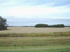
Saskatchewan can be divided into three regions: grassland
Grassland
Grasslands are areas where the vegetation is dominated by grasses and other herbaceous plants . However, sedge and rush families can also be found. Grasslands occur naturally on all continents except Antarctica...
(part of the Great Plains
Great Plains
The Great Plains are a broad expanse of flat land, much of it covered in prairie, steppe and grassland, which lies west of the Mississippi River and east of the Rocky Mountains in the United States and Canada. This area covers parts of the U.S...
) in the south, aspen parkland
Aspen parkland
Aspen parkland refers to a very large area of transitional biome between prairie and boreal forest in two sections; the Peace River Country of northwestern Alberta crossing the border into British Columbia, and a much larger area stretching from central Alberta, all across central Saskatchewan to...
in the center, and forest (taiga
Taiga
Taiga , also known as the boreal forest, is a biome characterized by coniferous forests.Taiga is the world's largest terrestrial biome. In North America it covers most of inland Canada and Alaska as well as parts of the extreme northern continental United States and is known as the Northwoods...
) in the north, part of the Canadian Shield
Canadian Shield
The Canadian Shield, also called the Laurentian Plateau, or Bouclier Canadien , is a vast geological shield covered by a thin layer of soil that forms the nucleus of the North American or Laurentia craton. It is an area mostly composed of igneous rock which relates to its long volcanic history...
. Its principal rivers are the Assiniboine River
Assiniboine River
The Assiniboine River is a river that runs through the prairies of Western Canada in Saskatchewan and Manitoba. It is a tributary of the Red River. The Assiniboine is a typical meandering river with a single main channel embanked within a flat, shallow valley in some places and a steep valley in...
, North
North Saskatchewan River
The North Saskatchewan River is a glacier-fed river that flows east from the Canadian Rockies to central Saskatchewan. It is one of two major rivers that join to make up the Saskatchewan River....
and South Saskatchewan
South Saskatchewan River
The South Saskatchewan River is a major river in Canada that flows through the provinces of Alberta and Saskatchewan....
.
Saskatchewan's economy is based on its abundant natural resources, notably petroleum
Petroleum
Petroleum or crude oil is a naturally occurring, flammable liquid consisting of a complex mixture of hydrocarbons of various molecular weights and other liquid organic compounds, that are found in geologic formations beneath the Earth's surface. Petroleum is recovered mostly through oil drilling...
, natural gas
Natural gas
Natural gas is a naturally occurring gas mixture consisting primarily of methane, typically with 0–20% higher hydrocarbons . It is found associated with other hydrocarbon fuel, in coal beds, as methane clathrates, and is an important fuel source and a major feedstock for fertilizers.Most natural...
, coal
Coal
Coal is a combustible black or brownish-black sedimentary rock usually occurring in rock strata in layers or veins called coal beds or coal seams. The harder forms, such as anthracite coal, can be regarded as metamorphic rock because of later exposure to elevated temperature and pressure...
, potash
Potash
Potash is the common name for various mined and manufactured salts that contain potassium in water-soluble form. In some rare cases, potash can be formed with traces of organic materials such as plant remains, and this was the major historical source for it before the industrial era...
, uranium
Uranium mining
Uranium mining is the process of extraction of uranium ore from the ground. The worldwide production of uranium in 2009 amounted to 50,572 tonnes, of which 27% was mined in Kazakhstan. Kazakhstan, Canada, and Australia are the top three producers and together account for 63% of world uranium...
and forests, and agriculture (wheat and other grains, and cattle ranching).
The original inhabitants of Saskatchewan were the Cree Indians in the south and central regions and the Dene
Dene
The Dene are an aboriginal group of First Nations who live in the northern boreal and Arctic regions of Canada. The Dené speak Northern Athabaskan languages. Dene is the common Athabaskan word for "people" . The term "Dene" has two usages...
in the north. The Hudson's Bay Company controlled the area named Rupert's Land
Rupert's Land
Rupert's Land, or Prince Rupert's Land, was a territory in British North America, consisting of the Hudson Bay drainage basin that was nominally owned by the Hudson's Bay Company for 200 years from 1670 to 1870, although numerous aboriginal groups lived in the same territory and disputed the...
beginning in 1670. The French established settlements in the region c. 1750, though the Hudson’s Bay Company made the first permanent settlement in 1774. The Hudson’s Bay Co. ceded Rupert’s land in 1869, and by 1870, the North West became a member of the Dominion of Canada as a part of the Northwest Territories
Northwest Territories
The Northwest Territories is a federal territory of Canada.Located in northern Canada, the territory borders Canada's two other territories, Yukon to the west and Nunavut to the east, and three provinces: British Columbia to the southwest, and Alberta and Saskatchewan to the south...
. From 1882 into the early 1900s, the extension of the railroad brought in large numbers of European settlers. Saskatoon
Saskatoon
Saskatoon is a city in central Saskatchewan, Canada, on the South Saskatchewan River. Residents of the city of Saskatoon are called Saskatonians. The city is surrounded by the Rural Municipality of Corman Park No. 344....
is the largest city and Regina
Regina, Saskatchewan
Regina is the capital city of the Canadian province of Saskatchewan. The city is the second-largest in the province and a cultural and commercial centre for southern Saskatchewan. It is governed by Regina City Council. Regina is the cathedral city of the Roman Catholic and Romanian Orthodox...
is the second largest city and capital.
Physical geography
Saskatchewan is an approximate trapezoid. Its western border runs concurrent with the 4th meridian or the 110°W longitude110th meridian west
The meridian 110° west of Greenwich is a line of longitude that extends from the North Pole across the Arctic Ocean, North America, the Pacific Ocean, the Southern Ocean, and Antarctica to the South Pole....
, separating Saskatchewan from the province of Alberta. This border extends in 1225 kilometres (761.2 mi) length and was established in 1905 when both provinces were formed. The eastern border is not the 102nd line of longitude
102nd meridian west
The meridian 102° west of Greenwich is a line of longitude that extends from the North Pole across the Arctic Ocean, North America, the Pacific Ocean, the Southern Ocean, and Antarctica to the South Pole....
, but rather is west of that meridian and is also an irregular line (rather than a straight one). Manitoba became a province in 1870, enlarging in 1882. The western boundary of Manitoba then was the road allowance between ranges 29 and 30 west of the prime meridian which was surveyed by 1930. When Saskatchewan was formed in 1905, Manitoba and the District of Keewatin
District of Keewatin
The District of Keewatin was a territory of Canada and later an administrative district of the Northwest Territories.The name "Keewatin" comes from Algonquian roots—either kīwēhtin in Cree or giiwedin in Ojibwe—both of which mean north wind in their respective languages...
were the neighboring areas to the east. Manitoba was enlarged again in 1912 north to the 60th parallel north
60th parallel north
The 60th parallel north is a circle of latitude that is 60 degrees north of the Earth's equatorial plane. It crosses Europe, Asia, the Pacific Ocean, North America, and the Atlantic Ocean....
becoming Saskatchewan's only eastern neighbor which separates Saskatchewan and Manitoba. This remaining section of the border was determined by surveyed between 1961 and 1972. The southern border is the Canada – United States border or the 49th parallel
49th parallel north
The 49th parallel north is a circle of latitude that is 49 degrees north of the Earth's equatorial plane. It crosses Europe, Asia, the Pacific Ocean, North America, and the Atlantic Ocean....
determined by the Convention of 1818. This boundary was not formally established until the 1867 survey. The Northwest Territories
Northwest Territories
The Northwest Territories is a federal territory of Canada.Located in northern Canada, the territory borders Canada's two other territories, Yukon to the west and Nunavut to the east, and three provinces: British Columbia to the southwest, and Alberta and Saskatchewan to the south...
is north of the 60th parallel
60th parallel north
The 60th parallel north is a circle of latitude that is 60 degrees north of the Earth's equatorial plane. It crosses Europe, Asia, the Pacific Ocean, North America, and the Atlantic Ocean....
which forms the northern border of the province. This border extends 445 kilometres (276.5 mi) across northern Saskatchewan.
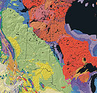
Geology
The geology of Saskatchewan can be divided into two main geological regions, the Pre-CambrianPrecambrian
The Precambrian is the name which describes the large span of time in Earth's history before the current Phanerozoic Eon, and is a Supereon divided into several eons of the geologic time scale...
or Canadian shield
Canadian Shield
The Canadian Shield, also called the Laurentian Plateau, or Bouclier Canadien , is a vast geological shield covered by a thin layer of soil that forms the nucleus of the North American or Laurentia craton. It is an area mostly composed of igneous rock which relates to its long volcanic history...
and the Phanerozoic or Western Canada Sedimentary Basin
Western Canadian Sedimentary Basin
The Western Canadian Sedimentary Basin is a vast sedimentary basin underlying of Western Canada including southwestern Manitoba, southern Saskatchewan, Alberta, northeastern British Columbia and the southwest corner of the Northwest Territories. It consists of a massive wedge of sedimentary rock...
. Within the Canadian shield exists the Athabasca sedimentary basin
Athabasca Basin
This article is about the uranium mining region near Lake Athabasca. Not to be confused with the drainage basin of the Athabasca River.The Athabasca Basin is a region of Northern Saskatchewan and Alberta Canada that is best known as the world's leading source of high grade uranium...
. Meteorite impacts have altered the natural geological formation
Geologic formation
A formation or geological formation is the fundamental unit of lithostratigraphy. A formation consists of a certain number of rock strata that have a comparable lithology, facies or other similar properties...
processes. The Quaternary period
Quaternary
The Quaternary Period is the most recent of the three periods of the Cenozoic Era in the geologic time scale of the ICS. It follows the Neogene Period, spanning 2.588 ± 0.005 million years ago to the present...
is the most recent geological process when the prairies were affected by glacial events. There are six notable meteorite or comet impact crater
Impact crater
In the broadest sense, the term impact crater can be applied to any depression, natural or manmade, resulting from the high velocity impact of a projectile with a larger body...
s in Saskatchewan. Carswell, Deep Bay and Gow Lake have affected the Canadian Shield area of the north. In the southern Phanerozoic crater are the Viewfield, Elbow and Maple Creek structures. The Carswell structure
Carswell crater
Carswell is an impact crater in northern Saskatchewan, Canada. It is in diameter and the age is estimated to be 115 ± 10 million years . The crater is exposed at the surface....
is largest astrobleme at 35 kilometres (21.7 mi) in diameter.
Historical geography
Archaeologists have dated the first human settlements to 9,500 BCE. The four groups inhabiting the area at the time of the first European contact were the CreeCree
The Cree are one of the largest groups of First Nations / Native Americans in North America, with 200,000 members living in Canada. In Canada, the major proportion of Cree live north and west of Lake Superior, in Ontario, Manitoba, Saskatchewan, Alberta and the Northwest Territories, although...
, Assiniboine, Salteaux and Dene
Dene
The Dene are an aboriginal group of First Nations who live in the northern boreal and Arctic regions of Canada. The Dené speak Northern Athabaskan languages. Dene is the common Athabaskan word for "people" . The term "Dene" has two usages...
. Henry Kelsey
Henry Kelsey
Henry Kelsey , aka the Boy Kelsey, was an English fur trader, explorer, and sailor who played an important role in establishing the Hudson's Bay Company. Kelsey was born and married in East Greenwich, south-east of central London...
of the Hudson's Bay Company is considered the first European person to see this area. The earliest trading post
Trading post
A trading post was a place or establishment in historic Northern America where the trading of goods took place. The preferred travel route to a trading post or between trading posts, was known as a trade route....
s were made by the French
France
The French Republic , The French Republic , The French Republic , (commonly known as France , is a unitary semi-presidential republic in Western Europe with several overseas territories and islands located on other continents and in the Indian, Pacific, and Atlantic oceans. Metropolitan France...
; however, the first permanent settlement was established at Cumberland House
Cumberland House, Saskatchewan
Cumberland House is a village in Census Division No. 18 in north-eastern Saskatchewan, Canada on the Saskatchewan River. It is the oldest community in Saskatchewan and has a population of about 2000 people...
in 1774 by the HBC. In addition, several more ports were set up by British fur trade
Fur trade
The fur trade is a worldwide industry dealing in the acquisition and sale of animal fur. Since the establishment of world market for in the early modern period furs of boreal, polar and cold temperate mammalian animals have been the most valued...
rs among the area's waterways. The forested area of the Canadian Shield was the favoured area for early settlement, and the economy was heavily dependant on hunting and trapping.
In 1870, the Hudson Bay's Company sold Rupert's Land
Rupert's Land
Rupert's Land, or Prince Rupert's Land, was a territory in British North America, consisting of the Hudson Bay drainage basin that was nominally owned by the Hudson's Bay Company for 200 years from 1670 to 1870, although numerous aboriginal groups lived in the same territory and disputed the...
and ceded its rights to the Canadian Government. The region became a part of the Northwest Territories. The majority of the Canadians of indigenous descent in the Northwest Territories sold their lands to the government in the 1870s and were settled on reservations. Additional native peoples and Métis
Métis people (Canada)
The Métis are one of the Aboriginal peoples in Canada who trace their descent to mixed First Nations parentage. The term was historically a catch-all describing the offspring of any such union, but within generations the culture syncretised into what is today a distinct aboriginal group, with...
(people of mixed French and indigenous Canadian ancestry), led by Louis Riel
Louis Riel
Louis David Riel was a Canadian politician, a founder of the province of Manitoba, and a political and spiritual leader of the Métis people of the Canadian prairies. He led two resistance movements against the Canadian government and its first post-Confederation Prime Minister, Sir John A....
, rebelled between 1884 and 1885 and were suppressed.
The arrival of settlements and the rail lines also brought agricultural economies and development in the Central Lowlands Area. The Great Plains or Palliser Triangle area to the south was mainly used for ranching economies. In the beginning of the 20th century, Saskatchewan farmers created cooperative organizations to maintain grain marketization. During the drought and depression of the 1930s, the population decreased as immigration nearly ended and numerous families left. During World War II
World War II
World War II, or the Second World War , was a global conflict lasting from 1939 to 1945, involving most of the world's nations—including all of the great powers—eventually forming two opposing military alliances: the Allies and the Axis...
, conservation programs and the increased demand for grain revived the economy.
Climate


Continental climate
Continental climate is a climate characterized by important annual variation in temperature due to the lack of significant bodies of water nearby...
, Köppen climate classification
Köppen climate classification
The Köppen climate classification is one of the most widely used climate classification systems. It was first published by Crimea German climatologist Wladimir Köppen in 1884, with several later modifications by Köppen himself, notably in 1918 and 1936...
types BSk, Dfb and Dfc. Hot to warm summers and cold winters mean that the annual temperature range
Temperature range
Atmospheric temperature range is the numerical difference between the minimum and maximum values of temperature observed in a given location....
can be up to 65°C. On average, Saskatchewan has 211 days per year when the temperature drops below freezing. Plough winds, Supercell
Supercell
A supercell is a thunderstorm that is characterized by the presence of a mesocyclone: a deep, continuously-rotating updraft. For this reason, these storms are sometimes referred to as rotating thunderstorms...
hail or high precipitation rain storms and tornadoes are eventful summer occurrences. Midale
Midale, Saskatchewan
-Area statistics:*Lat 49° 24' 00" N*Long 103° 24' 00" W*Dominion Land Survey 22-5-11-W2*Time zone UTC-6-Climate:-Location:-See also:* List of weather records* Highway 702...
reached 45 °C (113 °F) on July 5, 1937, the highest recorded temperature in Canada,.
Compared to average values from all thirteen Canadian provinces and territories, Saskatchewan is the sunniest province or territory year round (2206 hours per year), has the second lowest annual snowfall (145 cm), the fourth lowest total precipitation (428 mm) and the second hottest summer (22.5 °C). The number of frost-free
Frost free
Auto-defrost, automatic defrost or self-defrosting is a technique which regularly defrosts the evaporator in a refrigerator or freezer...
days ranges from 95 days in the north (Prince Albert, for example) to as high as 124 days in the south (Estevan).
Urban areas
Saskatchewan's capital is ReginaRegina, Saskatchewan
Regina is the capital city of the Canadian province of Saskatchewan. The city is the second-largest in the province and a cultural and commercial centre for southern Saskatchewan. It is governed by Regina City Council. Regina is the cathedral city of the Roman Catholic and Romanian Orthodox...
. Its most populous city is Saskatoon
Saskatoon
Saskatoon is a city in central Saskatchewan, Canada, on the South Saskatchewan River. Residents of the city of Saskatoon are called Saskatonians. The city is surrounded by the Rural Municipality of Corman Park No. 344....
. Other major cities include Estevan, Flin Flon
Flin Flon
Flin Flon is a Canadian mining city located on the border of Manitoba and Saskatchewan, with the majority of the city located within Manitoba.- Founding :...
(part), Humboldt
Humboldt, Saskatchewan
Humboldt is a Canadian city located in the province of Saskatchewan, 113 km east of Saskatoon at the junction of Highway 5 and Highway 20. The city is surrounded by the Rural Municipality of Humboldt No...
, Lloydminster
Lloydminster
Lloydminster is a Canadian city which has the unusual geographic distinction of straddling the provincial border between Alberta and Saskatchewan...
(part), Melfort
Melfort, Saskatchewan
Melfort is a small Canadian city in Saskatchewan, approximately southeast of Prince Albert, northwest of Saskatoon and north of Regina.According to The World Gazetteer, its population as of 2004 was 5,400...
, Melville
Melville, Saskatchewan
Melville is a small Canadian city located in the east-central portion of Saskatchewan. It was declared a city by the province in 1960. The city is north east of the provincial capital of Regina and south west of Yorkton. According to The World Gazetteer, it has a 2004 population of approximately...
, Moose Jaw, North Battleford, Prince Albert
Prince Albert, Saskatchewan
Prince Albert is the third-largest city in Saskatchewan, Canada. It is situated in the centre of the province on the banks of the North Saskatchewan River. The city is known as the "Gateway to the North" because it is the last major centre along the route to the resources of northern Saskatchewan...
, Swift Current, Weyburn, and Yorkton.
Flora
Indigenous (ecology)
In biogeography, a species is defined as native to a given region or ecosystem if its presence in that region is the result of only natural processes, with no human intervention. Every natural organism has its own natural range of distribution in which it is regarded as native...
flora
Flora
Flora is the plant life occurring in a particular region or time, generally the naturally occurring or indigenous—native plant life. The corresponding term for animals is fauna.-Etymology:...
of the Saskatchewan
Saskatchewan
Saskatchewan is a prairie province in Canada, which has an area of . Saskatchewan is bordered on the west by Alberta, on the north by the Northwest Territories, on the east by Manitoba, and on the south by the U.S. states of Montana and North Dakota....
includes vascular plants, plus additional species of other plant
Plant
Plants are living organisms belonging to the kingdom Plantae. Precise definitions of the kingdom vary, but as the term is used here, plants include familiar organisms such as trees, flowers, herbs, bushes, grasses, vines, ferns, mosses, and green algae. The group is also called green plants or...
s and plant-like organisms such as algae, lichen
Lichen
Lichens are composite organisms consisting of a symbiotic organism composed of a fungus with a photosynthetic partner , usually either a green alga or cyanobacterium...
s and other fungi, and mosses. Non-native species of plants are recorded as established outside of cultivation in Saskatchewan, of these some non-native species remain beneficial for gardening, and agriculture, where others have become invasive, noxious weeds. Saskatchewan is committed to protecting species at risk in Canada. The growing season
Growing season
In botany, horticulture, and agriculture the growing season is the period of each year when native plants and ornamental plants grow; and when crops can be grown....
has been studied and classified into plant hardiness zones
Hardiness zone
A hardiness zone is a geographically defined area in which a specific category of plant life is capable of growing, as defined by climatic conditions, including its ability to withstand the minimum temperatures of the zone...
depending on length of growing season and climatic conditions. Biogeographic
Biogeography
Biogeography is the study of the distribution of species , organisms, and ecosystems in space and through geological time. Organisms and biological communities vary in a highly regular fashion along geographic gradients of latitude, elevation, isolation and habitat area...
factors have also been divided into ecoregions and floristic kingdoms across Saskatchewan, and natural vegetation varies depending on elevation, moisture, soil and weather. The study of ethnobotany
Ethnobotany
Ethnobotany is the scientific study of the relationships that exist between people and plants....
uncovers the interrelation between humans and plants and the various ways people have used plants for economic reasons, food, medicine and technological developments. The Government of Saskatchewan has declared 3 indigenous plants as provincial symbols
Symbols of Saskatchewan
Saskatchewan is one of Canada's provinces, and has established several provincial symbols.-Symbols:...
.
Fauna
The fauna of Saskatchewan include many land and aquatic speciesSpecies
In biology, a species is one of the basic units of biological classification and a taxonomic rank. A species is often defined as a group of organisms capable of interbreeding and producing fertile offspring. While in many cases this definition is adequate, more precise or differing measures are...
. From the multiplicity of invertebrate
Invertebrate
An invertebrate is an animal without a backbone. The group includes 97% of all animal species – all animals except those in the chordate subphylum Vertebrata .Invertebrates form a paraphyletic group...
s and vertebrate
Vertebrate
Vertebrates are animals that are members of the subphylum Vertebrata . Vertebrates are the largest group of chordates, with currently about 58,000 species described. Vertebrates include the jawless fishes, bony fishes, sharks and rays, amphibians, reptiles, mammals, and birds...
s two have been chosen as symbols of Saskatchewan
Symbols of Saskatchewan
Saskatchewan is one of Canada's provinces, and has established several provincial symbols.-Symbols:...
, the White-tailed deer
White-tailed Deer
The white-tailed deer , also known as the Virginia deer or simply as the whitetail, is a medium-sized deer native to the United States , Canada, Mexico, Central America, and South America as far south as Peru...
and the Sharp-tailed grouse
Sharp-tailed Grouse
The Sharp-tailed Grouse, Tympanuchus phasianellus , is a medium-sized prairie grouse. It is also known as the sharptail, and is known as "fire grouse" or "fire bird" by Native American Indians due to their reliance on brush fires to keep their habitat open.-Taxonomy:The Greater Prairie-chicken,...
. Cenozoic
Cenozoic
The Cenozoic era is the current and most recent of the three Phanerozoic geological eras and covers the period from 65.5 mya to the present. The era began in the wake of the Cretaceous–Tertiary extinction event at the end of the Cretaceous that saw the demise of the last non-avian dinosaurs and...
vertebrate fossil
Fossil
Fossils are the preserved remains or traces of animals , plants, and other organisms from the remote past...
s reveal the geological evolution
Geology of Saskatchewan
The geology of Saskatchewan can be divided into two main geological regions, the Precambrian Canadian Shield and the Phanerozoic Western Canadian Sedimentary Basin. Within the Precambrian shield exists the Athabasca sedimentary basin. Meteorite impacts have altered the natural geological...
of the interior plains
Interior Plains
The Interior Plains is a vast physiographic region that spreads across the Laurentian craton of central North America.-Geography:The Interior Plains are an extensive physiographic division encompassing 8 distinct physiographic provinces, the Interior Low Plateaus, Great Plains, Central Lowland,...
and its prehistoric biogeography. Today, Saskatchewan's ecosystems range from the sub-arctic
Subarctic
The Subarctic is a region in the Northern Hemisphere immediately south of the true Arctic and covering much of Alaska, Canada, the north of Scandinavia, Siberia, and northern Mongolia...
tundra
Tundra
In physical geography, tundra is a biome where the tree growth is hindered by low temperatures and short growing seasons. The term tundra comes through Russian тундра from the Kildin Sami word tūndâr "uplands," "treeless mountain tract." There are three types of tundra: Arctic tundra, alpine...
of the Canadian Shield
Canadian Shield
The Canadian Shield, also called the Laurentian Plateau, or Bouclier Canadien , is a vast geological shield covered by a thin layer of soil that forms the nucleus of the North American or Laurentia craton. It is an area mostly composed of igneous rock which relates to its long volcanic history...
in north Saskatchewan to aspen parkland
Aspen parkland
Aspen parkland refers to a very large area of transitional biome between prairie and boreal forest in two sections; the Peace River Country of northwestern Alberta crossing the border into British Columbia, and a much larger area stretching from central Alberta, all across central Saskatchewan to...
, and grassland prairie
Prairie
Prairies are considered part of the temperate grasslands, savannas, and shrublands biome by ecologists, based on similar temperate climates, moderate rainfall, and grasses, herbs, and shrubs, rather than trees, as the dominant vegetation type...
. Fauna inhabit areas unique to their own specific and varied breeding, foraging and nesting requirements. With a large land and water area, and small population density, the ecoregions of Saskatchewan
Flora of Saskatchewan
The native flora of the Saskatchewan includes vascular plants, plus additional species of other plants and plant-like organisms such as algae, lichens and other fungi, and mosses...
provide important habitat for many animals, both endangered and not. Naturalists observing wildlife have enumerated shrinking and growing wildlife populations. They advocate programs and methods to preserve or re-introduce endangered species
Endangered species
An endangered species is a population of organisms which is at risk of becoming extinct because it is either few in numbers, or threatened by changing environmental or predation parameters...
and identify programs of control for outbreaks of wildlife populations. A broad diversity of wildlife habitats are preserved as parks and reserves protecting the feeding and breeding grounds of protected and indigenous fauna of Saskatchewan.
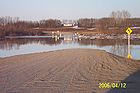
Hydrography
- see also List of Saskatchewan rivers, Lakes of Saskatchewan, Lakes of Canada
The total area of freshwater is 59,366 km2. There are two main river basins, the Nelson and Churchill River Basins, both of which drain into Hudson Bay
Hudson Bay
Hudson Bay , sometimes called Hudson's Bay, is a large body of saltwater in northeastern Canada. It drains a very large area, about , that includes parts of Ontario, Quebec, Saskatchewan, Alberta, most of Manitoba, southeastern Nunavut, as well as parts of North Dakota, South Dakota, Minnesota,...
. Qu'Appelle
Qu'Appelle River
The Qu'Appelle River is a Canadian river that flows 430 km east from Lake Diefenbaker in southwestern Saskatchewan to join the Assiniboine River in Manitoba, just south of Lake of the Prairies, near the village of St. Lazare....
and Souris
Souris River
The Souris River or Mouse River is a river in central North America. It is about 700 km in length and drains about . It rises in the Yellow Grass Marshes north of Weyburn, Saskatchewan...
, the North
North Saskatchewan River
The North Saskatchewan River is a glacier-fed river that flows east from the Canadian Rockies to central Saskatchewan. It is one of two major rivers that join to make up the Saskatchewan River....
and South Saskatchewan
South Saskatchewan River
The South Saskatchewan River is a major river in Canada that flows through the provinces of Alberta and Saskatchewan....
, confluence is east of Prince Albert
Prince Albert, Saskatchewan
Prince Albert is the third-largest city in Saskatchewan, Canada. It is situated in the centre of the province on the banks of the North Saskatchewan River. The city is known as the "Gateway to the North" because it is the last major centre along the route to the resources of northern Saskatchewan...
becoming the Saskatchewan
Saskatchewan River
The Saskatchewan River is a major river in Canada, approximately long, flowing roughly eastward across Saskatchewan and Manitoba to empty into Lake Winnipeg...
which are all a part of the Nelson river
Nelson River
The Nelson River is a river of north-central North America, in the Canadian province of Manitoba. Its full length is , it has mean discharge of , and has a drainage basin of , of which is in the United States...
basin. The Churchill River
Churchill River (Hudson Bay)
The Churchill River is a major river in Alberta, Saskatchewan and Manitoba, Canada. From the head of the Churchill Lake it is 1,609 km long. It was named after John Churchill, 1st Duke of Marlborough and governor of the Hudson's Bay Company from 1685 to 1691...
connects lakes and streams through the lower portion of the Canadian shield. Rupert's Land
Rupert's Land
Rupert's Land, or Prince Rupert's Land, was a territory in British North America, consisting of the Hudson Bay drainage basin that was nominally owned by the Hudson's Bay Company for 200 years from 1670 to 1870, although numerous aboriginal groups lived in the same territory and disputed the...
a historical political division of Canada comprised all lands of the Hudson Bay drainage system
Drainage system (Geomorphology)
In geomorphology, a drainage system is the pattern formed by the streams, rivers, and lakes in a particular drainage basin. They are governed by the topography of the land, whether a particular region is dominated by hard or soft rocks, and the gradient of the land. Geomorphologists and...
between the years 1670 to 1870. Frenchman River
Frenchman River
Frenchman River, or Frenchman Creek, is a river in Saskatchewan, Canada and Montana, United States. It is a tributary of the Milk River, itself a tributary of the Missouri.The river is approximately long....
does not flow east to Hudson Bay, but rather south to the Missouri River
Missouri River
The Missouri River flows through the central United States, and is a tributary of the Mississippi River. It is the longest river in North America and drains the third largest area, though only the thirteenth largest by discharge. The Missouri's watershed encompasses most of the American Great...
, which is part of the Missouri river basin catchment area
Drainage basin
A drainage basin is an extent or an area of land where surface water from rain and melting snow or ice converges to a single point, usually the exit of the basin, where the waters join another waterbody, such as a river, lake, reservoir, estuary, wetland, sea, or ocean...
. The Mackenzie River
Mackenzie River
The Mackenzie River is the largest river system in Canada. It flows through a vast, isolated region of forest and tundra entirely within the country's Northwest Territories, although its many tributaries reach into four other Canadian provinces and territories...
basin of north Saskatchewan flows north draining into the Arctic Ocean
Arctic Ocean
The Arctic Ocean, located in the Northern Hemisphere and mostly in the Arctic north polar region, is the smallest and shallowest of the world's five major oceanic divisions...
, which belongs to the Mackenzie river basin drainage area
Drainage basin
A drainage basin is an extent or an area of land where surface water from rain and melting snow or ice converges to a single point, usually the exit of the basin, where the waters join another waterbody, such as a river, lake, reservoir, estuary, wetland, sea, or ocean...
.
There are over 10 thousand lakes across Saskatchewan, the main lake region being north of the tree line in the Canadian Shield. Saskatchewan's largest lake is Lake Athabasca
Lake Athabasca
Lake Athabasca is located in the northwest corner of Saskatchewan and the northeast corner of Alberta between 58° and 60° N.-History:The name in the Dene language originally referred only to the large delta formed by the confluence the Athabasca River at the southwest corner of the lake...
which sits astride the Saskatchewan - Alberta border. The second in size is Reindeer Lake
Reindeer Lake
Reindeer Lake is a lake in Western Canada located on the border between northeastern Saskatchewan and northwestern Manitoba, with the majority in Saskatchewan. The name of the lake appears to be a translation of the Algonquian name...
which is located on the Saskatchewan - Manitoba border. Other lakes of notable size would be Wollaston
Wollaston Lake
Wollaston Lake is located in northeastern Saskatchewan, Canada. With a surface area of 2286 km² , it is the largest lake in the world that drains naturally in two directions...
, Cree
Cree Lake
Cree Lake is a lake in Saskatchewan, Canada. The lake is the fourth largest in the province and is located west of Reindeer Lake and south of Lake Athabasca. There is no highway access, but the lake is reachable by float plane...
, Frobisher
Frobisher Lake
Frobisher Lake is a lake of Saskatchewan, Canada, located just south of Clearwater River, in northern Saskatchewan. It discharges into Churchill Lake and is thus part of the Churchill River drainage system. There is no road access...
, and Lac La Ronge
Lac la Ronge
Lac la Ronge is a glacial lake in Saskatchewan, Canada. It is the fifth largest lake in the province.It is approximately 250 km north of Prince Albert, on the edge of the Canadian Shield. La Ronge, Air Ronge and the Lac La Ronge First Nation are on the west shore. The lake is a popular...
. The deepest water point 220 metres (721.8 ft) is located in Reindeer Lake
Reindeer Lake
Reindeer Lake is a lake in Western Canada located on the border between northeastern Saskatchewan and northwestern Manitoba, with the majority in Saskatchewan. The name of the lake appears to be a translation of the Algonquian name...
at the Deep Bay Structure
Deep Bay crater
Deep Bay is a bay near the south-western tip of Reindeer Lake in Saskatchewan, Canada. The bay is strikingly circular and very deep in an otherwise irregular and shallow lake....
site which was created by a meteor impact
Impact event
An impact event is the collision of a large meteorite, asteroid, comet, or other celestial object with the Earth or another planet. Throughout recorded history, hundreds of minor impact events have been reported, with some occurrences causing deaths, injuries, property damage or other significant...
.
Saskatchewan is also home to preserved wetlands which are partially submerged areas of land. Saskatchewan's waterways also contain bogs, as well as the salt water lakes. Quill Lake is Canada's largest saltwater lake, Chaplin Lake
Chaplin, Saskatchewan
Chaplin is a rural village in Saskatchewan, Canada situated on the Trans-Canada Highway approximately 85 km from Moose Jaw and 90 km from Swift Current. The main industries of Chaplin are Saskatchewan Minerals and farming/ ranching. Chaplin consists of eight streets, two crescents, and...
is a Western Hemispheric Shorebird Reserve Network and Little Manitou, an ehdorheic lake, is a popular tourist resort. Brine shrimp
Brine shrimp
Artemia is a genus of aquatic crustaceans known as brine shrimp. Artemia, the only genus in the family Artemiidae, has changed little externally since the Triassic period...
siheries have existed on sodium magnesium sulphate
Magnesium sulfate
Magnesium sulfate is a chemical compound containing magnesium, sulfur and oxygen, with the formula MgSO4. It is often encountered as the heptahydrate epsomite , commonly called Epsom salt, from the town of Epsom in Surrey, England, where the salt was distilled from the springs that arise where the...
lakes such as Chaplin, Frederick, Ingebright, and Little Manitou lakes.
Provincial and National Parks
Saskatchewan has 34 provincial parkProvincial park
A provincial park is a park under the management of a provincial or territorial government in Canada.While provincial parks are not the same as national parks, their workings are very similar...
s that provide for recreational use or preserve wilderness, special environments or sites of historic importance.
The province is also home to two of Canada's 36 National Parks. Grasslands National Park
Grasslands National Park
Grasslands National Park is one of Canada's newer national parks, located in southern Saskatchewan, and one of 43 parks and park reserves in Canada's national park system...
, which covers 907 square kilometres (350.2 sq mi) in southernmost part of the province, was established in 1981. The other is Prince Albert National Park
Prince Albert National Park
Prince Albert National Park covers in central Saskatchewan, Canada and is located north of Saskatoon. Though declared a national park March 24, 1927, it had its official opening ceremonies on August 10, 1928 performed by Prime Minister William Lyon Mackenzie King. The park is open all year but...
covering 3874 square kilometres (1,495.8 sq mi) in central Saskatchewan, which was established in 1927.
Economic geography
The economy of Saskatchewan has been associated with agricultureAgriculture
Agriculture is the cultivation of animals, plants, fungi and other life forms for food, fiber, and other products used to sustain life. Agriculture was the key implement in the rise of sedentary human civilization, whereby farming of domesticated species created food surpluses that nurtured the...
resulting in the moniker Bread Basket of Canada and Bread Basket of the World. According to the Government of Saskatchewan, approximately 95% of all items produced in Saskatchewan, depend on the basic resources available within the province. Various grains, livestock, oil and gas, potash, uranium, wood and their spin off industries fuel the economy. Saskatchewan's GDP in 2006 was approximately C$45.922 billion,
See also
- The Saskatchewan ActThe Saskatchewan ActThe Saskatchewan Act is an Act of the Canadian Parliament establishing the new province of Saskatchewan, effective September 1, 1905. Its long title is An Act to establish and provide for the government of the Province of Saskatchewan. The Act was published in chapter 42, pages 201-215 of the...
- Geography of CanadaGeography of CanadaThe geography of Canada is vast and diverse. Occupying most of the northern portion of North America , Canada is the world's second largest country in total area....
- District of Assiniboia
- List of cities in Canada
- List of airports in Saskatchewan
- List of communities in Saskatchewan
- List of Canadian provincial and territorial symbols
- List of Saskatchewan rivers
- List of rural municipalities in Saskatchewan
- Symbols of SaskatchewanSymbols of SaskatchewanSaskatchewan is one of Canada's provinces, and has established several provincial symbols.-Symbols:...